Posts Tagged ‘dolphin’

Pimlico & Battersea 1988

Saturday, September 18th, 2021

Railway Bridge, River Thames, Battersea Power Station, Grosvenor Rd, Pimlico, Westminster, 1988 88-5f-62-positive_2400
Railway Bridge, River Thames, Battersea Power Station, Grosvenor Rd, Pimlico, Westminster, 1988 88-5f-62

These seven pictures all come from the same film I took at the end of a fairly long day’s walk around Chelsea on Sunday 8th May 1988 which had taken me down to the Thames on Grosvenor Road. I spent some time wandering around on the road and also where it was possible to get onto the riverbank, though most was fenced off.

Railway Bridge, River Thames, Battersea Power Station, Grosvenor Rd, Pimlico, Westminster, 198888-5f-64-positive_2400
Railway Bridge, River Thames, Battersea Power Station, Grosvenor Rd, Pimlico, Westminster, 19888 8-5f-64

The views today are rather different, although the railway bridge carrying the main line to and from Victoria is still much the same. In the pictures you can see some work being carried on in Battersea Power Station, but now new flats hide most of the building apart from the chimneys from here, and the gas works have completely gone.

Railway Bridge, River Thames, Battersea Power Station, Grosvenor Rd, Pimlico, Westminster, 1988 88-5f-51-positive_2400
Railway Bridge, River Thames, Battersea Power Station, Grosvenor Rd, Pimlico, Westminster, 1988 88-5f-51

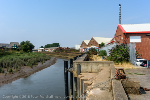
You may still see lighters moored in the river here, but I think this rather odd structure close to the mouth of the vestigial Grosvenor Canal here has gone. I wasn’t absolutely sure why there was this wooden platform with what looked to me like small dog-kennels on it, but perhaps as the rope shows they were simply for mooring barges waiting to use the canal. Technically I think this is a dolphin, as the picture below shows.

Chelsea Bridge, River Thames,Grosvenor Rd, Westminster, 198888-5f-52-positive_2400
Chelsea Bridge, River Thames,Grosvenor Rd, Westminster, 1988 88-5f-52

The first bridge here was built in 1858 when Chelsea Embankment was being built and was a suspension bridge intended to give the large population of Pimlico access to the new Battersea Park – if they could afford the toll – though it was made free on Sundays. It was then called Victoria Bridge, named like the station after the Queen. It became even less popular after Albert Bridge was built at the other end of the park in 1873. It was bought by the Metropolitan Board of Works in 1877 and they abolished the tolls in 1979. It was a narrow bridge and found to be structurally unsound, so fearing it might embarass the Queen if it collapsed they renamed it Chelsea Bridge. It didn’t collapse and apparently took several years to demolish when they decided to replace it with the current bridge which opened in 1937.

As the picture shows, the main cables are attached to the end of the bridge rather than on solid ground on the banks, and it was the first such ‘self-anchored’ suspension bridge in Britain. The LCC couldn’t afford to fund the entire cost and the Ministry of Transport only agreed to stand 60% oof the cost on the condition that all the materials used came from the British Empire.

When Billy Strayhorn named his most famous composition ‘Chelsea Bridge’ it was not this structure that he had in mind, but something more ethereal, probably Whistler’s Nocturne: Blue and Gold – Old Battersea Bridge.

Grosvenor Canal, entrance, River Thames, Pimlico, Westminster, 1988 88-5f-53-positive_2400
Grosvenor Canal, entrance, River Thames, Pimlico, Westminster, 1988 88-5f-53

I wrote at some length in a previous post about the Grosvenor Canal, London’s last working canal, still in use when I took this picture. You can see part of one of the barges still in use to carry Westminster’s rubbish downriver through the bridge.

Chelsea Bridge, River Thames, Battersea Power Station, Chelsea Embankment, Kensington & Chelsea, 1988 88-5f-43-positive_2400
Chelsea Bridge, River Thames, Battersea Power Station, Chelsea Embankment, Kensington & Chelsea, 1988 88-5f-43

The pictures here (and on Flickr) are from around 20 exposures I made on this small area of riverside, though many of the others are very similar. There were very few boats around moving on the river at the time.

Pagoda, Battersea Park, River Thames, Chelsea Embankment, Kensington & Chelsea, 1988 88-5f-34-positive_2400
Pagoda, Battersea Park, River Thames, Chelsea Embankment, Kensington & Chelsea, 1988 88-5f-34

I walked upriver along Chelsea Embankment on my way to catch a bus across Battersea Bridge to take me to Clapham Junction for the train home. On my way I took a few pictures of the impressive late-Victorian houses – which haven’t made it to my Flickr album – and four pictures across the river of the Battersea Park Peace Pagoda, this one of which has. I’m not sure about the framing and I think it would perhaps be better in a square format but I felt it had a suitably Japanese feel to it.

Reverend Gyoro Nagase at Hiroshima Day, Tavistock Square, 2019

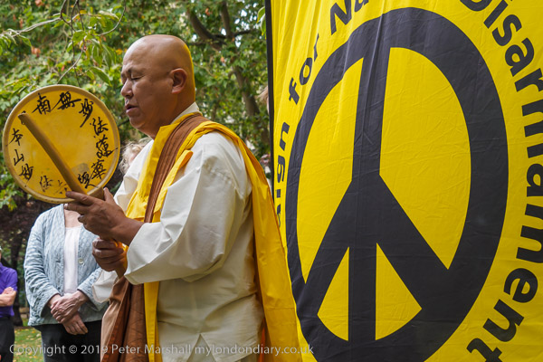
After the destruction of Hiroshima and Nagasaki by US atom bombs in August 1945, Nichidatsu Fuji who had in 1917 founded the Japanese Buddhist movement, Nipponzan Myohoji, in 1947 decided they would set up Peace Pagodas around the world to promote peace and non-violence. The first opened in Japan in 1954 and the London Peace Pagoda was built by Nipponzan Myohoji monks and opened in 1985, shortly after Nichidatsu Fuji died aged 100. Since 1978 it has been looked after by Reverend Gyoro Nagase who I have met and photographed at many events calling for peace. There are also Peace Pagodas in Milton Keynes and Birmingham among over 80 around the world.


Click on any of the black and white images to go to a larger version in my album 1988 London Photos from where you can browse to other images.


All photographs on this and my other sites, unless otherwise stated, are taken by and copyright of Peter Marshall, and are available for reproduction or can be bought as prints.


Hull Colour – 7

Saturday, July 18th, 2020
Lighthouse, Paull 81-04-Hull-043_2400

I think that Paull was one of the places we may have walked to during one of our stays in Hull, taking a bus to somewhere outside the city to a suitable starting point. There were a couple of time I hired a car, but I think only to go for holiday weeks elsewhere in Yorkshire. The last time I hired one I managed to drive it off the road into a ploughed field at some speed somewhere near Meaux (which despite the name is on the outskirts of Hull) and decided the time had come for me to give up driving.

Strangely given that back in 1965 when I first visited Hull was a city full of bicycles it was over 35 years before I ever cycled around the city. And when I did in 2003, I visited Paull for a second time, though actually riding there from Hornsea.

Paull is a riverside village on the north bank of the Humber a few miles south-east of Hull, just beyond Hedon Haven. Neither Paull nor Hedon grew as ports because sandbanks in the Humber made them unsuitable for larger ships, while a deepwater channel led towards the mouth of the River Hull.

Navigation in and out of Hull was tricky, and in 1836 Trinity House built the lighthouse at Paull for ships leaving Hull to steer towards, before picking up other lights on the south side of the estuary. Unfortunately the channel soon moved and by around 1870 this lighthouse was obsolete and was replaced by two ‘leading lights’ a little further downstream at Thorngumbald Clough.

This extensive Grade II listed property was offered for sale in 2013 for £169,950 though it is unclear if it was sold and a rather lower bid was considered. For those of us used to London prices it seems excessively cheap.

Mouth of River Hull, RIver Humber 81-04-Hull-044_2400

This picture amused me after photographing the Humber Bridge and I think I captioned it at the time as “Not the Humber Bridge” . The view is actually of both the River Hull, coming in from the left and the Humber across the top of the image, and the spit of mud and sand is Sammy’s Point, where Hull’s major tourist attraction, ‘The Deep’ now stands, a little back from the point here.

This was a short gangway leading out to a iron-sheathed concrete dolphin at the mouth of the River Hull from the end of Nelson St. The dolphin, designed as a temporary mooring in deep water for vessels waiting for the tide to go up the River Hull (and perhaps to protect the bank from vessels off course) is still there, but the promenade has been rebuilt to stretch to the dolphin, and a footpath now leads north from it beside the Hull.

Alley in Old Town, Hull 81-04-Hull-050_2400
Alley in Old Town, Hull 1981

I can’t remember precisely where this was, but the view through it is to the wholesale fruit and vegetable traders, probably on Humber St, though possibly on Wellington St. I think this may have been an alley leading from Blanket Row, but the area has changed too much for me to now be sure.

Clearly I was attracted by both the atmosphere of the alley leading to the street and by the colour, particularly the three areas of blue against the muted yellows. Blue mixed with yellow in my paintbox to make greens and green is the only other colour in this image.

Barge R57 moored at wharf north of Ferry Lane, Hull 81-04-Hull-052_2400
Barge R57 moored at wharf north of Ferry Lane, Hull 1981

The last time I was in Hull I sat eating a lunchtime snack beside the River Hull here, though the scene had changed a little.

There was actually a barge moored a little downstream, though looking rather derelict, but I was surprised to find that there were still a couple of buildings from the earlier image remaining.

East Hull Ladder Works, Hull 81hull81003_2400
East Hull Ladder Works, Hull 1981

I don’t know the name of the dog or the name of the street where the East Hull Ladder Works then stood, but am fairly sure that it and the houses along the street either fell down or were demolished not long after I made the picture.

Probably this was a side-street off of Holderness Rd, well-placed for timber which came into Hull’s Victoria Dock. The rapid growth of Hull during the 19th century with its tremendous boom in house building will have created considerable demand for ladders.

Holderness Rd, 1977 – East Hull

And there were certainly plenty of them for sale on the Holderness Road as this picture from my web site ‘Still Occupied – A View of Hull‘ shows.

Sissons Paints, mosaic, Clough Rd, Bankside, Hull 81-04-Hull-058_2400
Sissons Paints, mosaic, Clough Rd, Bankside, Hull 81

Sisson’s Paints were another famous brand from Hull, and their advertising often used their 1910 trademark of two painters carrying cans of paint and a plank. Sisson’s won a court case against a far-eastern company that copied it, replacing the plank with a ladder, but now Sissons Paints Malaysia, one of several foreign companies that continue its name, uses it with a ladder. In the early years adverts using it had the plank carrying the text ‘Hall’s. Distemper’, a product responsible for many gloomy hallways across the world, which over the years I’ve cleaned laboriously from several walls.

Sisson’s extensive works were beside the River Hull at Bankside and had this mosaic installed in 1953 (their 150th anniversary) when they were rebuilt after wartime bombing. The company was bought by Reckitt and Colman in 1964, sold on to the Donald Macpherson Group in 1968 and taken over by  Finland’s largest paint manufacturer Tikkurila Oy in 1984, though production in Hull had I think ceased before this and the plant looked derelict when I took this picture. It was demolished in the early 1990s and the mosaic lost. All that remains is the gates.

Part of the large area occupied by the factory is now more colourful than ever as a part of the Bankside Gallery which sprung up following Banksy’s addition ‘Draw The Raised Bridge’ on Scott Street bridge in January 2018.

Bankside Gallery, 2018

Hull Colour 1972-85 on Flickr.


All photographs on this and my other sites, unless otherwise stated, are taken by and copyright of Peter Marshall, and are available for reproduction or can be bought as prints.