Barging on Bow Creek – 2011

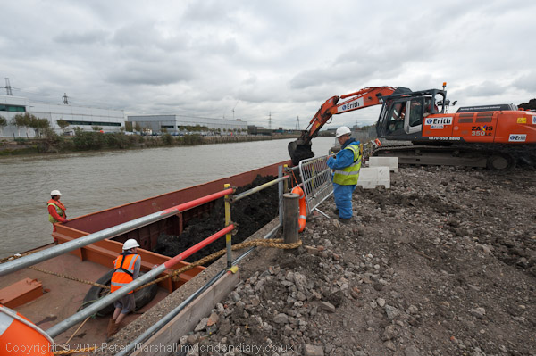
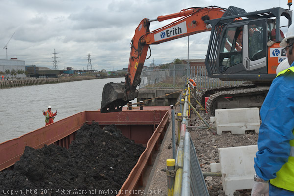
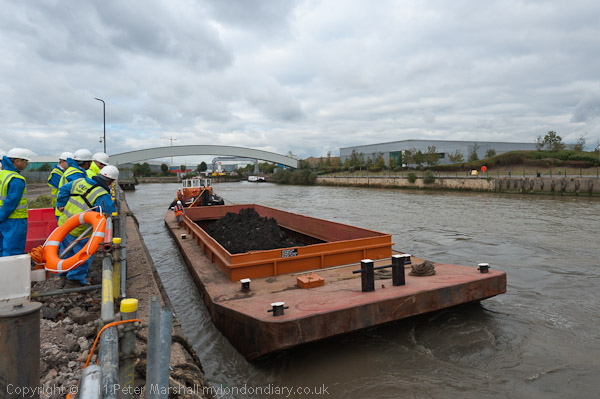
Barging on Bow Creek: On Wednesday 12 October 2011 I was pleased to get paid to go back to Bow Creek and take photographs of a working barge on Bow Creek in Poplar.
Barging on Bow Creek - 2011

Bow Creek is the lower part of the River Lea, between Bow Locks and the River Thames. Bow Locks mark the southern end of the Lea Navigation and since London’s oldest canal, the Limehouse Cut opened in 1770, most canal traffic took advantage of this to take a more direct route to the Thames and avoid the dangerous and meandering tidal Bow Creek.
Barging on Bow Creek - 2011

The River Lea remains tidal some miles above Bow Lock, but this tidal section is separate from the navigation, although there are various channels and locks such as City Mill Lock and Carpenters Lock on the Olympic site which link the two.

Barging on Bow Creek - 2011

Bow Creek continued to be used for navigation, including for bring coal to West Ham Power Station and the huge Imperial Gas Light & Coke Company gas works at Bromley-by-Bow.
Barging on Bow Creek - 2011

But the gas works closed in 1976 although its gasholders remain – they were still in use for gas storage until 2010. (I went inside the site to photograph them in 2022.) Planning permission has now been granted for 2,200 new homes on the site, retaining the seven gasholders. The gas works dock is now Cody Dock, a creative and community hub with moorings and a short walk from the DLR at Star Lane, hosting many intersting events.

West Ham Power Station ended production in 1983 and was then demolished to build a business park. In the lower sections of Bow Creek there were still a number of timber yards and a ship repair business still using the creek at least in the 1980s, but I think all all commercial traffic has now ended.

Much was made during the construction of the Olympic site of the use of barges to carry waste away from the area, and a new lock was built at great expense on the Prescott Channel at Three Mills Green, but I think barges were only used for PR photographs and the huge majority of waste was taken out by lorries.

So I was pleased to hear that “the people cleaning up the gas works site at Poplar … were using barges to carry out the highly toxic soil from the site* and “… “was delighted to be given a commission to go and photograph the barging.”

This is what a rubbish recycling plant looks like

On My London Diary I write more about my relationship with the River Lea which had begun in 1981 when “I heard a story on the radio that commercial barge traffic was about to come to an end on the Lea Navigation, and decided to travel across London to record its last days.” From then I carried out a major project on the river, but was disappointed to have a funding application turned down.

I returned to the River around ten years later and again in the early 2000s, with more frequent visits after the Olympic bid was successful – although access to the main site was soon impossible. In 2010 I published Before the Olympics, ISBN: 978-1-909363-00-7 with over 200 pictures from the source to the Thames.

The My London Diary post also describes my experience on the visit – how I had to dress up to take the pictures – and that although I’d been promised I would have half an hour to take photographs it actually ended up as 11 minutes.

After taking the pictures – both for the project PR and myself – I had the rest of the day to take a walk along Bow Creek again and made my way to the Thames on the Greenwich meridian, where I found “a new marker installed in the Virginia Quay estate next to West India Docks station, built since I carried out my ‘Meridian Project‘ in the 1990s and made an unsuccessful bid to create a’Meridian Walk’ to mark the new millennium.” Now there is a sculpture trail, The Line, which in part follows Bow Creek – and includes work at Cody Dock.

All pictures in this post are from Wednesday 12 October 2011. There are many more pictures from my walk as well as the barging at Barging on Bow Creek


FlickrFacebookMy London DiaryHull PhotosLea ValleyParis
London’s Industrial HeritageLondon Photos

All photographs on this page are copyright © Peter Marshall.
Contact me to buy prints or licence to reproduce.


Pimlico & Battersea 1988

Railway Bridge, River Thames, Battersea Power Station, Grosvenor Rd, Pimlico, Westminster, 1988 88-5f-62-positive_2400
Railway Bridge, River Thames, Battersea Power Station, Grosvenor Rd, Pimlico, Westminster, 1988 88-5f-62

These seven pictures all come from the same film I took at the end of a fairly long day’s walk around Chelsea on Sunday 8th May 1988 which had taken me down to the Thames on Grosvenor Road. I spent some time wandering around on the road and also where it was possible to get onto the riverbank, though most was fenced off.

Railway Bridge, River Thames, Battersea Power Station, Grosvenor Rd, Pimlico, Westminster, 198888-5f-64-positive_2400
Railway Bridge, River Thames, Battersea Power Station, Grosvenor Rd, Pimlico, Westminster, 19888 8-5f-64

The views today are rather different, although the railway bridge carrying the main line to and from Victoria is still much the same. In the pictures you can see some work being carried on in Battersea Power Station, but now new flats hide most of the building apart from the chimneys from here, and the gas works have completely gone.

Railway Bridge, River Thames, Battersea Power Station, Grosvenor Rd, Pimlico, Westminster, 1988 88-5f-51-positive_2400
Railway Bridge, River Thames, Battersea Power Station, Grosvenor Rd, Pimlico, Westminster, 1988 88-5f-51

You may still see lighters moored in the river here, but I think this rather odd structure close to the mouth of the vestigial Grosvenor Canal here has gone. I wasn’t absolutely sure why there was this wooden platform with what looked to me like small dog-kennels on it, but perhaps as the rope shows they were simply for mooring barges waiting to use the canal. Technically I think this is a dolphin, as the picture below shows.

Chelsea Bridge, River Thames,Grosvenor Rd, Westminster, 198888-5f-52-positive_2400
Chelsea Bridge, River Thames,Grosvenor Rd, Westminster, 1988 88-5f-52

The first bridge here was built in 1858 when Chelsea Embankment was being built and was a suspension bridge intended to give the large population of Pimlico access to the new Battersea Park – if they could afford the toll – though it was made free on Sundays. It was then called Victoria Bridge, named like the station after the Queen. It became even less popular after Albert Bridge was built at the other end of the park in 1873. It was bought by the Metropolitan Board of Works in 1877 and they abolished the tolls in 1979. It was a narrow bridge and found to be structurally unsound, so fearing it might embarass the Queen if it collapsed they renamed it Chelsea Bridge. It didn’t collapse and apparently took several years to demolish when they decided to replace it with the current bridge which opened in 1937.

As the picture shows, the main cables are attached to the end of the bridge rather than on solid ground on the banks, and it was the first such ‘self-anchored’ suspension bridge in Britain. The LCC couldn’t afford to fund the entire cost and the Ministry of Transport only agreed to stand 60% oof the cost on the condition that all the materials used came from the British Empire.

When Billy Strayhorn named his most famous composition ‘Chelsea Bridge’ it was not this structure that he had in mind, but something more ethereal, probably Whistler’s Nocturne: Blue and Gold – Old Battersea Bridge.

Grosvenor Canal, entrance, River Thames, Pimlico, Westminster, 1988 88-5f-53-positive_2400
Grosvenor Canal, entrance, River Thames, Pimlico, Westminster, 1988 88-5f-53

I wrote at some length in a previous post about the Grosvenor Canal, London’s last working canal, still in use when I took this picture. You can see part of one of the barges still in use to carry Westminster’s rubbish downriver through the bridge.

Chelsea Bridge, River Thames, Battersea Power Station, Chelsea Embankment, Kensington & Chelsea, 1988 88-5f-43-positive_2400
Chelsea Bridge, River Thames, Battersea Power Station, Chelsea Embankment, Kensington & Chelsea, 1988 88-5f-43

The pictures here (and on Flickr) are from around 20 exposures I made on this small area of riverside, though many of the others are very similar. There were very few boats around moving on the river at the time.

Pagoda, Battersea Park, River Thames, Chelsea Embankment, Kensington & Chelsea, 1988 88-5f-34-positive_2400
Pagoda, Battersea Park, River Thames, Chelsea Embankment, Kensington & Chelsea, 1988 88-5f-34

I walked upriver along Chelsea Embankment on my way to catch a bus across Battersea Bridge to take me to Clapham Junction for the train home. On my way I took a few pictures of the impressive late-Victorian houses – which haven’t made it to my Flickr album – and four pictures across the river of the Battersea Park Peace Pagoda, this one of which has. I’m not sure about the framing and I think it would perhaps be better in a square format but I felt it had a suitably Japanese feel to it.

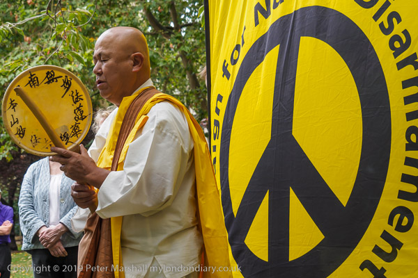
Reverend Gyoro Nagase at Hiroshima Day, Tavistock Square, 2019

After the destruction of Hiroshima and Nagasaki by US atom bombs in August 1945, Nichidatsu Fuji who had in 1917 founded the Japanese Buddhist movement, Nipponzan Myohoji, in 1947 decided they would set up Peace Pagodas around the world to promote peace and non-violence. The first opened in Japan in 1954 and the London Peace Pagoda was built by Nipponzan Myohoji monks and opened in 1985, shortly after Nichidatsu Fuji died aged 100. Since 1978 it has been looked after by Reverend Gyoro Nagase who I have met and photographed at many events calling for peace. There are also Peace Pagodas in Milton Keynes and Birmingham among over 80 around the world.


Click on any of the black and white images to go to a larger version in my album 1988 London Photos from where you can browse to other images.


All photographs on this and my other sites, unless otherwise stated, are taken by and copyright of Peter Marshall, and are available for reproduction or can be bought as prints.