I took a stroll along the King’s Road, looking at some of the shop windows, then explored some of the streets to the north.
Shop window, Kings Rd, Chelsea, Kensington and Chelsea, 1988 88-5b-52
There was something very strange about this view, and looking at when I made a print made me think that somehow it had turned into a negative. The contrast between the two mannequins, one white and one black had attracted me and I think the lighting and my treatment almost makes the right hand figure dissolve.
Kings Rd, Chelsea, Kensington and Chelsea, 1988 88-5b-64
Light fittings for sale in a shop window give some interesting shapes.
Boy, Kings Rd, Chelsea, Kensington and Chelsea, 1988 88-5b-65
Stephane Raynor opened BOY on the King’s Road in 1976, and it became “the epicentre of a new dawn in both fashion and music, defining the spirit of punk and birthing the New Romantic scene that appeared in its wake.”
Elm Park Rd, Chelsea, Kensington and Chelsea, 1988 88-5c-01
72 Elm Park Road is one of a row of individually designed late Victorian houses that make this an interesting street. Since I took this picture it has been extended with an extra storey at both top and bottom, but still looks much the same from the street. The house is now valued at around £12m and was named in 2015 as the address of one of the many people exposed in the The Panama Papers exposure of the rogue offshore finance industry
The Vale, Chelsea, Kensington and Chelsea, 1988 88-5c-03
I’m unsure why this property at 26 The Vale required such an elaborate security camera, something rather unusual back in 1988. I’m sure my framing, although I was mainly interested in the doorway was deliberately to include this. The building is a part of a corner site including joined properties in Elm Park Road, and plans were made in 2012 which would have involved the removal of this doorway. It was still there in 2020.
Fernshaw Rd, Chelsea, Kensington and Chelsea, 1988 88-5c-34
Taken from the corner of Edith Terrace and looking north up Fernshaw Rd (late Maude Grove). The taller block on the right in the distance is Fernshaw Mansions. an Edwardian block in this largely late Victorian street. The houses and garden walls are generally in rather better decorative state now than in 1988.
Fernshaw Rd, Chelsea, Kensington and Chelsea, 1988 88-5c-46
This unmodernised freehold house in Fernshaw Road was for sale in 1988 and if I had been able to afford it I should have bought it. It’s one of a terrace from 1-11 and would probably now sell for around £4m. I suspect the price in 1988 was around a hundreth of that.
Click on any of the pictures abouve to go to a larger version in my album 1988 London Photos, from where you can browse through all the pictures in the album.
All photographs on this and my other sites, unless otherwise stated, are taken by and copyright of Peter Marshall, and are available for reproduction or can be bought as prints.
Anderson St, Kings Road, Chelsea, Kensington and Chelsea, 1988 88-5a-21
It was the eye on the billboard that particulalry caught my attention on the corner of this long block of rather distressed looking shops and accomodation on the Kings Road, though I now have no idea what it was advertising and rather doubt if I did then. The long terrace has been considerably smartened now, with both advertising hoardings gone and the building has a smooth unblemised finish.
Royal Ave, Chelsea, Kensington and Chelsea, 1988 88-5a-22
Royal Avenue was first laid out as a part of a scheme connecting the Royal Hospital Chelsea with Kensington Palace which was apparently approved by Sir Christopher Wren in 1681, but only ever got as far as the King’s Road. At first it was planted with two rows of horse chestnut trees and grass and was known as Chestnut Walk, then it got white ladder stiles over the walls at each ends and became known as White Stiles. The terraces on each side date from around 1840 and are Grade II listed. The chestnuts were replaced by lime and plane trees and the grass by gravel around the same time, and it was renamed Royal Avenue in 1875. In 1970 the road access to King’s Road was replaced by a broad area of pavement. It still looks much the same as when I made this picture in 1988.
Kings Road, Chelsea, Kensington and Chelsea, 1988 88-5a-23
Another view of the King’s Road that is relatively unchanged, although there is now a florists stall which would have obscured this view. Strangely the council have replaces the plain but elegant bollards here with rather more ornate versions which seem rather less in keeping with the elegant white stucco architecture of Wellington Square, behind me as I made this image. The square was developed around the time of the death of the Duke of Wellington in 1852 and was named for him.
The Pheasantry, Kings Road, Chelsea, Kensington and Chelsea, 1988 88-5a-13
The Pheasantry got its name from Samuel Baker who bred new breeds of pheasants and other species there in the nineteenth century, though the present building is thought largely to have been built and embellished after the building was bought in 1880 by Amédée Joubert & Son, upholsterers and sellers of furniture, tapestry and carpets. In the early 20th century it also housed artists and a ballet school, and from 1932 when Felix Joubert retired the basement became a bohemian restaurant and drinking club with a host of famous actors and artists among its patrons. The club closed in 1966, the basement becoming a nightclub and the rest of the building flats. Now it houses a branch of Pizza Express and a cabaret club. Wikipedia has more.
The Pheasantry, Kings Road, Chelsea, Kensington and Chelsea, 1988 88-5a-24
The listing text describes this as “Central entrance with split segmental pediment supported by 2 male caryatids.”
Shop window, Elystan St, Chelsea, Kensington and Chelsea, 1988 88-5a-33
Elystan Street runs from the miniscule remains of Chelsea Common and was originally called College St. Here in 1913 the William Sutton Trust built 14 red-brick blocks of model dwellings, designed by E C P Monson, with 674 dwellings for around 2,000 working-class residents of Chelsea. Another large estate was also begun close to this in 1913 by the Samuel Lewis Housing Trust, with eight blocks of model dwellings completed after the First World War to house 1,390 people. (British History Online.)
Elystan St, Chelsea, Kensington and Chelsea, 1988 88-5a-35
Elystan St is better known now as the name adopted by a restaurant at No 43 with a Michelin star.
Monkeys, Restaurant, Cale St, Chelsea, Kensington and Chelsea, 1988 88-5a-36
Monkeys in Cale St, also leading from the residual Chelsea Common, a small triangle of grass in a road junction looks more my kind of restaurant. It faces that triangle and still looks very similar, but now claims to be “London’s best Neapolitan pizzeria”.
Click on any of the pictures to see a larger version and to browse other images in my album 1988 London Photos.
All photographs on this and my other sites, unless otherwise stated, are taken by and copyright of Peter Marshall, and are available for reproduction or can be bought as prints.
It was too hard to resist the Michelin Building any time I walked past, though I felt it had already been photographed to death – and most of my pictures were in colour, including closer views of its decorative panels.
Opened in 1911 as the first UK headquarters and tyre depot for the Michelin Tyre Company Ltd, and designed by Michelin employee and engineer François Espinasse it was more an architectural advertising hoarding featuring the Michelin Man ‘Bibendum’, his name derived from “Nunc Est Bibendum“, “Now is the time to drink”. A precursor of art-deco, it is grade II listed. It was also a fairly early use of ferro-concrete, using the Hennebique system, which gave its interior wide spaces for a tyre bay and made it relatively fire-proof. This picture was made three years after Michelin moved out, when the building was redeveloped by publisher Paul Hamlyn and restaurateur/retailer Sir Terence Conran as offices, shop and restaurant. (mainly from Wikipedia.)
This house is on the west corner of Pelham Crescent, and the three trees that attracted my attention are still there, remarkably little changed 33 years later, though of course each spring they get covered with leaves.
Selwood Terrace, South Kensington, Kensington & Chelsea, 1988 88-4r-61
The east side of this street is Neville Terrace and the west side is Selwood Terrace. This front garden with a wall covered with ivy is close to the Fulham Road and I think both wall and ivy have disappeared, possibly as a part of a basement extension to the property.
South Parade, Chelsea, Kensington & Chelsea, 1988 88-4r-62
I think this tall building probably dates from around 1892 and is part of long terrace including a former fire station with that date on the north side of Chelsea Square. It was the Nurses Home for the Royal Brompton Hospital and is still a part of the hospital. Chelsea square was named Trafalgar Square when it was laid out in 1810 but that was later used for a rather larger square in Westminster. The square later became a tennis club before much of the area was rebuilt in neo-Georgian style in the 1930s.
The Crown, Dovehouse St, Chelsea, Kensington & Chelsea, 1988 88-4r-63
The Crown pub is on the corner of Dovehouse St and Dudmaston Mews, just a few yards south of the Fulham Rd and more or less surrounded by hospitals. No longer a Whitbread pub it has lost the crown sign, replaced by a dreary sign with a neon crown, and other largely flowery embellishments have ruined the simplicity of the frontage. The Princess Of Wales at the left of the row of buildings closed as a pub around 2000 and is now a French restaurant, with considerably more expensive food than The Crown.
Kings Road, Chelsea, Kensington and Chelsea, 1988 88-5a-11
I took fewer pictures of the Kings Road than I should have done. This shop window display seemed more erotic than most.
Kings Road, Chelsea, Kensington and Chelsea, 1988 88-5a-16
These rather disparate buildings are still there on the Kings Road, on the south side just east of Radnor Walk, though now occupied by different shops and rather less trendy.
Jubilee Place, Chelsea, Kensington and Chelsea, 1988 88-5a-15
And immediately opposite the previous picture is Jubilee place, leading north with this house and wrought ironwork at No 9 over double gates leading down to a basement garage.
Click on any of the images to go to larger versions in my album 1988 London Photos were you can browse through these and other pictures.
All photographs on this and my other sites, unless otherwise stated, are taken by and copyright of Peter Marshall, and are available for reproduction or can be bought as prints.
Royal College Of Organists, Kensington Gore, Kensington & Chelsea, 1988 88-4d-61
I’m not a great fan of organs, an instrument generally used in churches to overpower the combined forces of both choir and congregation and to glorify the immense ego of the organist intent on world domination. I think my mental predictive text tends to replace the ‘rg’ with an ‘n’, both words concerning an excessive interest in organs. Of course they can be played with sensitivity, or so I’m told. Visually organs often add interest to church interiors, and this building seems to me to perfectly express the idea of the organ, visually punning on those pipes and also having a ridiculous showoffiness.
Queen Alexandra’s House nearby also has a musical theme, but is considerably more restrained. It was founded in 1884 by Sir Francis Cook Bar to provide accommodation for women students at the Royal College of Music, Royal College of Art and the Royal College of Science, and apparently still serves a similar but wider purpose. Queen Alexandra is I think largely forgotten now. She was born in 1844 as Princess Alexandra Caroline Marie Charlotte Louise Julia of Schleswig-Holstein-Sonderburg-Glucksburg, a relative of Queen Victoria, and moved up the scale when a conference of Austria, France, Prussia, Russia and the United Kingdom made her dad King of Denmark in 1863 and her brother became King of Greece.
But by this time, Queen Victoria had decided her heir Albert Edward needed a wife and although she wasn’t the first choice (and he was enjoying one of his many affairs that continued after his marriage) the two were married in 1863. When Victoria died, Albert became King Edward VII and she became Queen Alexandra. Both as Princess of Wales and Queen she carried out many royal duties and supported many charities – including the one that set up this house, and was a keen photographer, issuing a book of her photographs, Queen Alexandra’s Christmas Gift Book, to raise money for charity in 1908.
Queen’s Gate Gardens, South Kensington, Kensington & Chelsea, 1988 88-4e-22
Rolls-Royce DYR6 enjoys a suitably elevated position in front of some suitably grand housing in Queen’s Gate Gardens. The development of 127 houses and 51 stables around the square is said to have been a model for later Victorian Garden Squares. The grand design of the houses was probably laid down by the Commissioners for the Exhibition of 1851 who purchased a large slab of South Kensington, parts of which were used for the various museums etc.
This is not St Stephen’s Church which is on the corner of Gloucester Road and Southwell Gardens, but on the continuation of that road on the opposite side of Grenville Place in Emperor’s Gate and is St Stephen’s Church Hall. I think it may have been actually in use as a church when I made the photograph, but now is a health centre, a hall for hire and has a kindergarten.
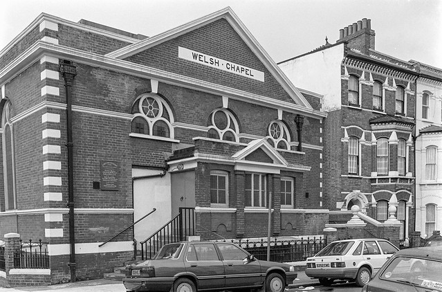
This area was sold by Lord Kensington to the Metropolitan warily way in 1867 and lies just to the east of the junction where the Circle Line parts company with the District, known as the ‘Cromwell Curve’. The railway let this South Kensington Baptist Chapel be built here in 1868-9, and in 1873 it became English Presbyterian – and they added this porch. Around 1930 it became the Russian Orthodox Church in Exile.
Middle-class housing was developed here in 1871-3. Initially the developers wanted to name this Alexandra Gate (after the Princess of Wales), but this was vetoed by the authorities and they came up with Emperor’s Gate, possibly a reference to the German Emperor – another of our royal family. The Survey of London says the mews behind the road on the south side, adjoining the railway was named McLeod’s Mews after “Sir Donald McLeod, a local resident and ex-Lieutenant-Governor of the Punjab, who died in November 1872 after attempting to board a moving train at Gloucester Road Station, falling between train and platform and suffering fearful mutilation.”
Eldon Road with its urns, lion and unicorn and at the top St George and a dragon comes at the west end of a short and rather plainer brick terrace, apparently built in 1852. But I’ve been unable to find out more about it. Eldon Road is a short street with a rather eclectic selection of houses as well as Christ Church Kensington. Hardy Amies (1909-2003) lived four doors along the road from 1961 to 1979 at 17b Eldon Road, not surprisingly making a number of alterations to the fabric.
Kensington Court Place, St Alban’s Grove, Kensington, Kensington & Chelsea, 1988 88-4e-64
The Builders Arms is still a pub of sorts, now a gastropub with an extensive and fairly expensive menu and craft ales on tap while I think when I took this picture it was a local where crisps and nuts and pork scratchings probably were the main foods on offer. Similarly although there is a shop opposite, it is no longer a launderette but considerably more upmarket where you can buy a pearl and jade harmony necklace for a mere £3,800. I think you now have to take your washing quite out of the area.
Clicking on any of the images will take you to the album 1988 London Photos with larger versions of these pictures and from where you can browse through over 1300 more pictures from the many I made in London that year.
All photographs on this and my other sites, unless otherwise stated, are taken by and copyright of Peter Marshall, and are available for reproduction or can be bought as prints.
I can’t look at the picture without thinking there should be people on folding bicycles cycling around this small oval island.
Brompton Square isn’t a square, but a long thin rectangle with a garden at its centre off the Brompton Rd, and at its far end is this rounded terrace with its own small oval of private garden in front of it. The square was developed by James Bonnin in 1821 and appears to have changed little with most of the houses now Grade II listed. Three houses sport blue plaques, including one for Stéphane Mallarmé who lived at No 6 in 1863, but the street had and has other famous residents, including “Britain’s most successful serial confidence trickster”, Achilleas Kallakis who bought No 31 at centre-right in this picture in the 2000s for £28 million, proceeding to have the garden dug out for a three-storey basement.
Andrew Ritchie, the inventor of the Brompton Bicycle company was working as a gardener in the area while working on the prototypes for his folding bike and took the name from the Brompton Oratory, whose dome was visible from his bedroom workshop. I’ve ridden a Brompton since 2002, though still prefer my 1980s road bike.
You will search in vain for the Prince of Wales pub in Fairholt St, replaced in 2015-7 by a “Luxury infill development” featuring something like the retained pub front, a “hi-end single family dwelling, a stone throw from Harrods” which ” boasts a two-level basement, 5 bedrooms, a lift, a spa and a home cinema”, designed by AR Architecture with a construction budget of £3m. The development gained the architects the “Best Architecture Single Residence” award by the United Kingdom Property Awards 2019-20.
The pub was established in 1831 in what was then Middle Street, Montpelier Row. In 1989 it was renamed ‘The Swag & Tails’, and changed from a friendly local to a gastro-pub. According to the Closed Pubs UK web site it was bought and closed in 2009, reportedly “by Tamara Ecclestone (daughter of F1 supremo Bernie) with a view to either rebuilding or expanding the premises considerably and turn it into a late night venue.”
This gatepost in Montpelier Terrace has lost the small and rather delicate urn which surmounted it in 1988, and the gardens here are now rather better kept and the houses in a much smarter condition. There is now very little of the small pockets of attractive dereliction that relieved the area then.
The Seer, Sculpture, Knightsbridge, Kensington & Chelsea, 1988 88-4b-52
Gilbert Ledward (1888-1960) produced many war memorials and other monumental architecture with a number of examples still visible around London – including the Venus Fountain in Sloane Square and the bronze sculptures on the Guards Memorial in Horseguards Parade. The Seer was produced around 1957 for the forecourt of Mercury House, 195-199 Knightsbridge, built in 1956–9.
Mercury House was demolished in 2002, replaced by The Knightsbridge Apartments, completed in 2005. I don’t know what has become of ‘The Seer’. Feel free to comment if you do.
This was the last sculpture completed by Jacob Epstein (1880-1959) shortly before his death and depicts a father, mother, son and dog rushing forwards off from the plinth, encouraged by Pan, the Greek God of the Wild, playing his pipes. Variously known as The Rush of Green, Pan or The Bowater House Group, it was commissioned by the chairman of the Land Securities Investment Trust to stand in front of their newly built offices at Bowater House. When this was demolished in 2006 to be replaced by a yet more hideous new development the sculpture was removed and in 2010 re-installed some distance west in the re-located Edinburgh Gate, its figures again rushing into the green of Hyde Park.
Russian Orthodox Cathedral of the Dormition, Ennismore Gardens, Knightsbridge, Westminster, 1988 88-4c-46
Originally built as All Saints, an Anglican Church, in 1849, desinged by Lewis Vulliamy in a Lombard style rather than the prevailing Gothic, the church ran out of cash and was only completed in 1860. Then it was given a facelift in 1891-2, with a new west front based on the Basilica of St Zeno of Verona in Verona, Italy. A parish merger made the church redundant in 1955 and it was leased to a Russian Orthodox congregation, who consecrated it in the name of one of their great feasts, the Dormition of the Mother of God. It was later bought by the Russian Orthodox Church.
These mews were built for the coaches for the large houses in Ennismore Gardens and Rutland Gate with stabling for the horses and rough accomodation for the servants who looked after the horses and drove the carriages. Ennismore Mews were rather grander than most, reflecting the quality of the houses in Ennismore Gardens which were developed in the 1868-74 by Peter and Alexander Thorn. Their company also built a new Blackfriars Bridge, and used some of the stone salvaged from the old bridge to face the Ennismore Gardens houses. The mews buildings were rather more basic structures, and have been converted to residential use, now selling for around £3.75m.
I was amused by the range of rather unusual structures, including the tower of Holy Trinity Brompton and the dome of the London Oratory along with some lesser features. The gateway at left is the entrance to Ennismore Garden Mews.
Click on any of the pictures to go to a larger version in my album 1988 London Photos from where you can browse these and other pictures.
All photographs on this and my other sites, unless otherwise stated, are taken by and copyright of Peter Marshall, and are available for reproduction or can be bought as prints.
Pont St, Knightsbridge, Kensington & Chelsea, 1988 88-3i-01
Back in 1988 I seem to have sentenced myself to wander extensively along Pont St, in earlier days one of London’s most fashionable streets and still one of its more expensive, linking Knightsbridge and Belgravia.
Pont St, Knightsbridge, Kensington & Chelsea, 1988 88-3i-55
Pont Street gets its name from the bridge over the river Westbourne, probably close to where Cadogan Lane now crosses the street close to its east end. Knightsbridge too was named for its bridge over this river, which flows down from Hampstead Heath to the Thames in Chelsea, passing across Sloane Square Underground Station in a very visible 19th century iron aqueduct. The bridge is still marked on maps from 1830 when the east section of Pont St was first developed but by 1840 the river had disappeared underground.
Pont St, Knightsbridge, Kensington & Chelsea, 1988 88-3i-56
Pont Street originally was developed to the east of Sloane St and was only developed to the west in the late 1870s, with building continued in the following decade. Cadogan Square was built between 1877 and 1888.
‘Pont St’ became a synonym for the snobbish posh, and the architectural style of most the area around Pont St west of Sloane St was called by Osbert Lancaster ‘Pont St Dutch’. In Pevsner and Cherry’s London 3 North West, published in 1991 it is described as “tall sparingly decorated red brick mansions for very wealthy occupants, in the semi-Dutch, semi-Queen Anne manner of Shaw or George & Peto”. It is very handy for both Harrods and Sloane Square.
Pont St, Knightsbridge, Kensington & Chelsea, 1988 88-3i-64
A welcome departure from this incredible rash of red-brick is St Columba’s Church, designed by Sir Edward Maule for the Church of Scotland. Completed in 1955 it replaced the orginal 1884 St Columba’s Church on the same site which had been destroyed by bombing in 1941. I think it altogether a more attractive building than Maule’s Guildford Cathedral.
St Columba’s Church Of Scotland, church, Pont St, Knightsbridge, Kensington & Chelsea, 1988 88-3j-62
Pont Street has had some famous residents, including Lillie Langtry who lived for five years at No 21. This became a part of the Cadogan Hotel, where famously Oscar Wilde was arrested in 1985.
Hans Place, Knightsbridge, Kensington & Chelsea, 1988 88-3i-66
All pictures (and more) in my album 1988 London Photos – and you can see a larger version of the images and browse through the album by clicking on any of them.
Oak House, Old Palace Place, King St, Richmond, 1988
I went to Richmond fairly often fairly in my youth some 25 years or so before I took these pictures, sometimes on my bike, on the 37 bus from Hounslow Garage or by car with a friend from school who had a part-time job and could afford to run a Morris Minor. On the bike I would generally ride around Richmond Park, and I took my first cassette of black and white film mainly of the trees there, sending them away to be processed and getting back 36 crinkle-edged black and white enprints. D & P cost something like 17s11d (around 90p) and it was several years before I could afford to take another film. The prints were a dull grey, with no trace of either white or black, but even well-printed they would have been of no great interest.
Flooding, River Thames, Richmond, 1988
When we went together in my mate’s car, often with a third friend, it was to sit with a cup of coffee on the terrace of a coffee bar, watching the girls go by while our coffee cooled. I doubt we could ever afford more than a single cup, and certainly none of us had the nerve to talk to any of those passing girls. Richmond at the time was full of young foreign au-pairs, all rather older than us.
Flooding, River Thames, Richmond, 1988
I think most of my bus journeys were made on my own, visiting the Palm Court Hotel to listen to jazz in the bar there, standing making a pint of bitter (probably Red Barrel or Worthington E – I then knew no better) last and last as I couldn’t afford another. It was always a rather lonely evening, with little conversation – though occasionally some older man would attempt to pick me up but I wasn’t interested. But there was some truly great music from the likes of Bobby Wellins.
Flooding, River Thames, Richmond, 1988
Later, in my thirties, I would visit Richmond regularly, having joined the photographic society there and made a few friends who shared some of my photographic interests. Club photography was in general tired and formulaic and had little to offer, but became used to doing my own thing often to the derision of the majority of the members. I still remember the frisson of revulsion when a visiting judge for an inter-club competion not only praised my entry but awarded it one of the prizes.
Flooding is frequent at Richmond, where the Thames is still tidal (though a half-lock prevents it draining out completely at low tide) and there are always motorists who ignore the warning notices. I think it comes up over parts of the towpath most months during Spring Tides. These pictures were taken in March when I had probably come on one of my regular visits to a couple of second-hand bookshops that often had decent photographic books in stock at a time when these were rare. Many were review copies, probably never reviewed but sold to the dealers as one of the perks of a poorly-paid job. I decided if ever I became a book reviewer (which eventually I did) I would never sell copies, and I didn’t though there were some I gave away, but many more I refused to take.
Once a month we came to visit friends in Kennington, arriving for lunch on a Sunday, and I would often travel up earlier than the rest of my family and spend some time walking around and taking pictures, and I think this may have been taken on one of those mornings. I think I will have chosen this angle on the ornamented Heath Terrace carefully, not just to show the 4 white chimneys of Battersea Power Station at left, but also the rather Lego-like tower block at right, and choosing to put a concrete post at the right edge.
Heath Terrace is still there, though I think now entirely residential, and I’m not sure you can still see the power station, certainly not in summer when Streetview is on its rounds, as that small tree has grown considerably. The concrete post, which I assume was a lamp post as well as holding some other sign has disappeared.
Clapham Manor St, Clapham, Lambeth, 1988
This Grade II listed building at 42 Clapham Manor St is now home to the London Russian Ballet School and Kids Love Lambeth. It was built in 1854, architect by James Thomas Knowles Snr, as the Clapham General Dispensary for the ‘The Clapham Sick Poor Fund’ formed in 1849 and provided free medical and surgical services for almost a century, closing in the early 1950s.
In 1959 the building was used by the London County Council for industrial training for people with special needs. It later became a pre-school playground and adult education centre, which I think it was at the time of my photograph. Shortly after in 1989 it became empty and suffered some fire damage which led to considerable internal rebuilding. Still owned by Lambeth council, it became a taxi training school until 2005-6 when the council sold the building and its considerable premises at the rear. For some years it was in illegal use as ballet studios, with this being made legal in 2013.
James Thomas Knowles Snr (1806-1884) designed the building free of charge and it was paid for by public subscription. As well as its architectural merit is is listed as one of the earliest provident dispensaries to survive in London.
All photographs on this and my other sites, unless otherwise stated, are taken by and copyright of Peter Marshall, and are available for reproduction or can be bought as prints.
Helpfully a street sign and a number inform me that this is 180 Shepherds Bush Rd, at the western edge of Brook Green. The road at one time used to wander around here but long ago traffic was routed straight through the grassy space, with both new and old road remaining as Shepherds Bush Road. There are no properties on the new section of the road, just a bus stop, traffic signs and traffic lights.
Without the information on the photo it would be hard to place this picture, as nothing visible remains of this part of the factory which housed Express Lifts and was I think part of the large Osram works which had began making carbon lamps here in 1881. It went on to produce many other types of lamps until around 1955, continuing only to produce argon and electronic valves until 1988 and was demolished the same year, with only its tower with the famous Osram Dome elsewhere on the site being saved, incorporated into the Tesco Superstore that took its place
You can still find this pair of houses on Sinclair Rd, part of one of many conservation areas in Hammersmith & Fulham. There are a number of houses with impressive paired porches on the street, substantial four storey houses dating from around 1880. This pair is one of relatively few to have retained the stucco urns under the porticos, and this is a particularly impressive example with slender columns and capitals, but I think the real attraction for me was the incredibly morose bearded and moustached crowned head at the base of a finial.
In the same conservation area as Sinclair Rd is a small section of very different housing. This small block which contained around 24 late Victorian terraced houses with a small Radiator Factory at its north end had been replaced by these modern buildings by 1988. The picture is taken from the road at the south side of this small estate.
St John the Baptist, Church, Holland Rd, Holland Park, Kensington & Chelsea, 1988
Crossing the railway at the bridge on Addison Gardens took me from Hammersmith & Fulham into the Holland Park area of Kensington & Chelsea and St John the Baptist Church in Holland Rd, a remarkably exuberant Grade I listed building by the distinguished Victorian church architect James Brook, “cathedral-like in scale and ambition, combining Brooks’s devotion to severe early Gothic models with a degree of material opulence not seen in his better-known East End churches”. Begun in 1872 it was completed in stages when the parish had the money and only finished after Brook’s death with finishing touches (perhaps unfortunate) by his successor John Standen Adkins in 1910.
The well-illustrated feature on the history of the church on the church web site states “St John’s is a distinguished and integrated time-capsule of the Anglo-Catholic movement. It is regularly in use for that traditional form of worship today.”
15 Holland Park Gardens, Holland Park, Kensington & Chelsea, 1988
The London School of English is still in this imposing building in Holland Park Gardens. Perhaps surprising I avoided the wide sweep of steps leading up to its door, probably in order to emphasise the nest of balloons tied to its railings.
Addisland Court, Holland Villas Road, Holland Park, Kensington & Chelsea, 1988 88-1a-11
Addisland Court is a prestigious block of flats that screams 1930s Art Deco and its site design also very much reflects the golden age of motoring (when it was only for the rich.) A three bedroom flat here has an estimated value of around £2million. It was apparently used as a location in a couple of episodes of a TV series of Agatha Christie’s Poirot. It was built in 1936, designed by William Bryce Binnie whose other works include the East Stand at Arsenal’s old Highbury ground and who after distinguished war service had been assistant architect at the Imperial War Graves Commission for which he designed a number of memorials in France and Belgium.
All photographs on this and my other sites, unless otherwise stated, are taken by and copyright of Peter Marshall, and are available for reproduction or can be bought as prints.
Holland Park Ave, Holland Park, Kensington & Chelsea, 1988
I made these pictures in January 1988, on one of many walks around various areas of London. At the time I was working on two photographic projects, one in black and white and the other in colour. In black and white I was largely concerned with recording the physical infrastructure, photographing both buildings and streets I felt were exceptional and also examples that I thought were typical. My colour project was more difficult to explain, but both were linked to the changing nature of London.
Holland Park Ave, Holland Park, Kensington & Chelsea, 1988
January was a good month to take pictures of the streets. One of the smaller projects I’d undertaken was about trees in London, and in the Summer months they hide many of the buildings. Google Streetview is a great resource, but almost all the images around London appear to be from late Spring or Summer, and for some streets almost all you can see is trees. My project on the buildings of London tailed off around 1999 to 2000 because it then seemed to me that it would not be long before we would have something like Streetview with more comprehensive coverage, though it hasn’t entirely replaced the kind of pictures I took.
Holland Park Ave, Holland Park, Kensington & Chelsea, 1988
Holland Park Avenue is an ancient route to the West from London dating back to before the Romans. In later years until the nineteenth century it was known here as the Uxbridge Road. Land to the south of it was a part of the Holland House estate and from the middle of the 18th century land to the north became owned by the Ladbroke family of wealthy bankers. In 1819 after he inherited the land James Weller Ladbroke began to develop it, beginning with the parts along the Uxbridge Road.
The first houses along the road were built in 1824, but proved difficult to let or sell being so far from the centre of London. Building on the Ladbroke estate halted in the mid-1830s but began again in the following decade. When built, each terrace had its own name and house numbers, but in 1895 this section of Uxbridge Road was renamed Holland Park Avenue and the houses renumbered. You can read more about them on the Ladbroke Association web site.
Holland Rd, Holland Park, Kensington & Chelsea, 1988
Holland Road is a rather busy street that leads up from the south to the Holland Park roundabout at the western boundary of Notting Hill and was a part of the Holland estate whose development was carefully overseen by Lord and later Lady Holland. Just to its west is the railway line- now part of the London Overground network as well as carrying National Rail trains and the Underground service as far as Kensington Olympia.
The original plans for the railway in the mid 1830s had it going on a viaduct a short distance to the east close to Addison Road and new houses already built on the Holland estate, and an objection by Lord Holland moved the line to the edge of his estate and largely hidden in a cutting – as well as enabling him to see a few acres to the railway company for £5,000 and get them to largely finance a new covered sewer that ran along Holland Road enabling its development.
Kiln, Walmer Rd, Notting Hill, Kensington & Chelsea, 1988
Walmer Road is the oldest street in Notting Dale, an old footpath which became the main street of the area and was renamed James St in the early 19th century and Walmer Road in the 1850s. Much of the area was dug for clay and bricks and tiles were made here and the area became known as the Potteries – and also because of the pigs kept in the area, the Piggeries. It became a notorious slum area with high levels of cholera, lacking proper sanitation until a new sewer was dug around 1850. The worked out brickfield ‘Ocean’ was filled in in the 1860s, part becoming Avondale Park in 1892. The kiln, a designated Ancient Monument, is opposite the park.
House, 106, Princedale Rd, Notting Hill, Kensington & Chelsea, 1988
Walmer Road is one of those that was cut short by the building of the Westway and it used to go north to meet Latimer Road. It now comes to an end just south of Grenfell Tower. It’s southern end is also confusing, with a junction with Princedale Road, Kenley Street, Hippodrome Place and Pottery Lane. I think Princedale Rd (formerly Prince’s Rd) along with Pottery Lane may well also have once been part of the old footpath which became Walmer Rd. The two roads run closely parallel and Pottery Lane rather looks like a mews – and its opposite side was once the stables for the racecourse.
Prince’s Road was developed piecemeal between 1841-1851. It became Princedale Road in the late 1930s to remove the confusion with several other Prince’s Roads in London. There are no listed buildings in the road which in 1978 became part of the Norland Conservation Area.
This shop on the corner of Portland Road and Clarenden Cross is still there with its half pots and name ‘Fired Earth’ a reminder of the origin of the area as the ‘Potteries’, about a hundred yards from the remaining kiln in a picture above.
My introduction to this area came in the book ‘Absolute Beginners’ by Colin MacInnes published in 1959 which I read when I was a teenager and which is loosely based around the Notting Hill race riots of 1958, later filmed. It has rather gone up in the world since then.
All photographs on this and my other sites, unless otherwise stated, are taken by and copyright of Peter Marshall, and are available for reproduction or can be bought as prints.
Stanley Crescent, Notting Hill, Kensington & Chelsea, 1988
When James Weller Ladbroke inherited his 300 acre largely rural estate on the western edge of London in 1819 he wanted to develop the area and employed landscape architect Thomas Allason to draw up a picturesque plan based on his visits to Italy and the London example of John Nash’s Regent’s Park. It was a plan that Ladbroke never found the money to build, but influenced some of those the estate sold land to and can still be seen in the map of the area, most of which was built up in the 1850s with large villas and terraces and in parts retained the communal private gardens between the streets.
Stanley Gardens, Notting Hill, Kensington & Chelsea, 1988
Stanley Crescent and Stanley Gardens were developed by Charles Blake, who returned from running a highly profitable business in India and bought the area from Felix Ladbroke in 1852. He got artist and architect Thomas Allom to design the area based on Allason’s plans.
The streets were probably named after Lord Stanley who was Prime Minister in three separate short governments from 1852 on. In them he abolished slavery and reformed Parliment and created the modern Conservative party. Building began in 1853.
Stanley Crescent, Notting Hill, Kensington & Chelsea, 1988
Allom was architect for the houses on the estate and, according to the Survey of London his designs broke away from the late Georgian restraint of earlier streets inn the area “in favour of a grand display in the latest taste … with scenic effect uppermost in his mind. The design of houses, streets, gardens and tree planting is seen with a painter’s eye, so that each turn and every vista is composed in a picturesque manner…”
Lansdowne Rd, Notting Hill, Kensington & Chelsea, 1988
Most of the houses remained in single ownership until after the First World War, when costs of upkeep became ridiculous and they were converted for multi-occupation and often allowed to deteriorate. By the time I took these pictures this process was in reverse, with houses being renovated and wealthier tenants paying considerably higher rents and some houses converted back to single family occupancy as the area became popular among the ultra-rich.
Lansdowne Rd, Notting Hill, Kensington & Chelsea, 1988
Landsdowne Road was also a part of the Ladbroke Estate, built around 10 years earlier than Stanley Crescent in the 1840s, while the estate was still owned by James Weller Ladbroke. He let plots to various developers to build, and the road lacks the overall view of the later area, with some quite varied houses. This suggests that the name ‘Landsdowne’ comes from “the much admired Montpellier and Lansdown residential estates in Cheltenham, built in the first three decades of the 19th century”. Alternatively it might have been named for another prime minister, William Petty, Earle of Shelburne, who served briefly in 1782-3, after which he was made 1st Marquess of Lansdowne. His major achievement as prime minister was securing a treaty which lead to the end of the American War of Independence.
Lansdowne Rd, Notting Hill, Kensington & Chelsea, 1988
Again you can read a detailed account of the buildings on the street on the http://www.ladbrokeassociation.info/LansdowneRoad.htm Ladbroke Association web site.
Lansdowne Rd, Notting Hill, Kensington & Chelsea, 1988
When I was taking these pictures in 1988, information about this and many other areas of London was relatively hard to find. There was of course no World Wide Web and few books with any detailed description outside the City of London and some parts of Westminster. The volume of The Buildings of England by Cherry and Pevsner for this area was only published in 1991. In areas such as this, almost all I had to guide me was the A-Z and other street maps.
All photographs on this and my other sites, unless otherwise stated, are taken by and copyright of Peter Marshall, and are available for reproduction or can be bought as prints.