Around Warton Road

Robbialac, Warton Rd, Stratford, Newham, 1983 35p-15_2400
Jenson and Nicholson, Robbialac Works, Warton Road, Stratford, London E15.

Jensen and Nicholson were the makers of Robbialac paints and had premises here on Warton Road, offices on the Goswell Rd and a further works in Stratford on Carpenters Rd. The business was started in 1821 at the Barbican by William Kingham and John Jenson became a partner in 1840, taking over the business in 1848. He was joined in 1856 by Wilfred Nicholson.

Following a fire which destroyed the company’s factory, Nicholson decided to move to Stratford Marshes and a few years later Nicholson took over the company, which continued to trade under the name Jenson and Nicholson Ltd. As well as Robbialac enamel paints for cars and home decoration, the company also made Copal varnishes and distributed Cuprinol wood preservatives. In 1960 they merged with Berger Paints forming Berger, Jenson and Nicholson who after various takeovers became a part of Crown Paints and were then acquired by the Dutch company Akzo Nobel. (Information from Grace’s Guide https://www.gracesguide.co.uk/Jenson_and_Nicholson.)

The name Robbialac came from the 15th century Italian ceramicist Luca Della Robbia, famed for his brightly coloured enamels and the word lacquer. The major Portuguese paint manufacturer Tinta Robbialac, founded in 1928, also uses it as a brand name.

Bridgewater Rd, Stratford, Newham, 1983 35q-12_2400
Bridgewater Rd, Stratford, Newham, 1983

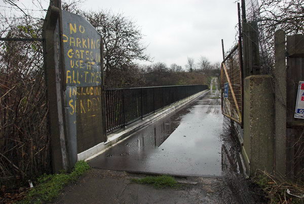
The concrete bridge here is an early use of ferro-concrete I think had a plaque on it stating it had been built using the Hennebique system and certainly deserves preservation. I photographed it on various occasions and it survived the Olympics and was still present when I last visited the area, but I’m unsure if it will be retained in the future.

Waterworks River, Bridgewater Rd, Stratford, 1983 36m-62-positive_2400
Waterworks River, Bridgewater Rd, Stratford, 1983

The view looking south from the Bridgewater Road bridge along the Waterworks River to the Warton House on Stratford High St, and blocks of flats on the opposite side of the street off Abbey Lane, Albert Bigg Point and Aubrey Moore Point. The footpath on the bank at right was extremely overgrown and the gates to it were locked. At right is one of the many pylons that were taken down for the Olympics.

Carpenters Rd, Stratford, Newham, 1983 35p-51_2400
Carpenters Estate, Stratford, Newham, 1983

I am not sure of the exact location of this doorway with its interesting use of concrete. There were (and are) 3 point blocks on the Carpenters Estate and I think the one in the background here may be Dennison Point and this building may have been on the site now occupied by the Building Crafts College in Kennard Road which moved to a new building here in 2001.

Waterworks River, Railway Bridge, Stratford, Newham, 1983 35q-32_2400
Waterworks River, Railway Bridge, Stratford, Newham, 1983

I think this is from the footpath beside the Waterworks River looking north towards the bridge carrying the Eastern Region main line from Liverpool St across to Stratford. Possibly I had climbed down from Bridgewater Road as I think this path was closed at the time. The factory at right was on Warton Rd.

Waterworks River, Blaker Rd, Stratford, 1983 36m-52_2400
Waterworks River, view towards Blaker Rd from the Greenway, Stratford, 1983

The Waterworks River turns to the left in the distance to go under Stratford High St, with a channel going on under Blaker Rd to City Mill lock. The concrete pillar is part of the bridge carrying the Northern Outfall Sewer across the river and I wondered if the profuse fig tree growing here might be benefiting from some warmth from the sewage or possibly even be nourished by some leakage.

Kerry's, Greenway, Northern Outfall Sewer, Stratford, Newham, 1983 35v-23_2400
Kerry’s, Stratford 1983.

Kerry’s were a company that made and distributed a wide range of products, both those they made themselves and others branded with their name. In 1961 according to Grace’s Guide they were “Wholesale distributors to the motor, radio, electrical and cycle trades, also machine tool makers, specialising in centre lathes, boring mills, power saws, drills and special purpose machines” and even produced a light weight moped, the Capitano. Manufacturing moved to Basildon in the 1960s and the business was bought up and sold at the end of the decade.

Although Kerry’s address was Warton Road, I think the factory was actually rather closer to the Northern Outfall Sewer and reached over the bridge on Bridgewater Road.

More pictures on Flickr.


All photographs on this and my other sites, unless otherwise stated, are taken by and copyright of Peter Marshall, and are available for reproduction or can be bought as prints.


Stratford Marsh & Carpenter’s Road

Pudding Mill River and Railway, Stratford Marsh, Stratford, Newham, 1990 90-9h66_2400
Pudding Mill River, Stratford Marsh, 1990

Continuing with pictures from my walks in the 1980s and early 1990s around the area destroyed for the London 2012 Olympics on Stratford Marsh. Although there was then considerable industry of various kinds across the area, many of the factories had closed, and some were derelict, partly as a result of Thatcher’s de-industrialisation policies, but also because of competition from more efficient industry abroad as well as from lower wage economies.

Pauls Cafe, Stratford Marsh, Stratford, Newham, 1990 90-9h63_2400
Paul’s Cafe served the many workers in the area

A few of the empty properties and sites were occupied by smaller local businesses such as car breakers and repair shops, and a few were transformed into artists studios – and I remember going to a great party in one of them off Marshgate Lane, though missing most such events as I lived thirty miles away on the other side of London.

City Mill River, Stratford Marsh, Newham, 1983 33x-34_2400
This path beside the City Mill River was well trodden during the fishing season. 1983

This was clearly a liminal area, on the edge of London and in some respects on the edge of society, even though it was surrounded on all sides by the city which now sprawls out much further east. In it there were also areas of wilderness, with paths beside the various streams of the River Lea across the area often overgrown and some largish areas of now disused land.

Caravan, Marshgate Lane, Stratford Marsh, Newham, 1982 32w-45_2400
Behind the caravan was the Queen Mary College nuclear engineering dept building. 1982

One large building next to the Pudding Mill River was the nuclear engineering department of Queen Mary College, which in 1966 had the first nuclear reactor of any UK university. This very small reactor was decommissioned about the time I made the picture which shows it behind a caravan and lorries parked beside the road.

Jerome Engineering Ltd, Johnson-Progress Ltd, Carpenters Rd, Stratford, Newham, 1983 92-8e23_2400
Jerome Engineering Ltd, Johnson-Progress Ltd, Carpenters Rd, Stratford, Newham, 1983

Although there was clearly considerable industry in the area, quite a few of the properties were empty. You can find more pictures from Carpenters Rd on page 3 of the Flickr album River Lea- Lea Navigation.

Asteroid Ltd, Carpenters Rd, Stratford, Newham, 1983 92-8e62_2400
Asteroid Ltd, Carpenters Rd, Stratford, Newham, 1983
Carpenters Rd, Stratford, Newham, 1983 35p-53_2400
Carpenters Rd, Stratford, Newham, 1983
Carpenters Rd, Stratford, Newham, 1983 35q-26_2400
Carpenters Rd, Stratford, Newham, 1983

The area now is unrecognisable – part of the largely still rather arid space of the new park. And although Carpenters Road still runs through the area, its sides are bare and bleak apart from the Aquatics Centre.


All photographs on this and my other sites, unless otherwise stated, are taken by and copyright of Peter Marshall, and are available for reproduction or can be bought as prints.


US Shame – Jan 11th

Many commentators after the recent Trump-induced invasion of the US Capitol said that the 6th January 2021 (1/6/21) is a date that will go down in history as a day of shame for the US, comparing it to December 7, 1941, the Japanese attack on Pearl Harbour. The latter was perhaps a little over the top, as that attack killed 2,403 US personnel, while the death toll after police let Trump supporters in to protest currently stands at five, three of these from health-related issues. But certainly it was a shameful day for US democracy – and a date that might well have been better compared to 1/11/02, 11th January 2002, the date when the first prisoners were held in illegal detention at Guantánamo Bay.

It was five years later than I first photographed a protest against this illegal detention, outside the US Embassy in London, still then in Grosvenor Square, where Amnesty International had brought over a hundred people dressed in orange jump suits to represent the detaines, forming them up into a large block in front of the embassy.

The following year on the sixth anniversary I photographed rather more demonstrations around London. Amnesty were back again outside the US Embassy, though the area in front of the embassy had been sealed off, presumably to prevent the protest taking place there. Instead it was on the street just to one side.

My next stop was the Regents Park Mosque, where I met a group of campaigners, some dressed in the now familiar orange jump suits, from the London Guantánamo Campaign and Cageprisoners who were handing out fliers calling for the closure of the Guantánamo prison camp at various sites around London all day. After giving them to people leaving the Mosque after Friday prayers I went with them to Paddington Green Police Station, where terrorist suspects were normally detained and questioned.

From there I returned to the US Embassy, where the pavement in front was now open again, and a small group from London Catholic Worker had come to hold a vigil. A man from the US Embassy came out and tried to get them to move away, but they stood their ground, lighting a circle of candles as it grew dark.

The final event of the day was a rally in Parliament Square, with speakers including former Guantánamo detainee Moazzam Begg (above) and leading campaigners for the closure of this illegal prison which has cast huge shame on the claims of the USA to be a freedom-loving democracy which upholds international law. Of course those claims have long been known to be largely sham, with the USA backing many of the world’s most repressive regimes, taking part in shady affairs such as the Bay of Pigs attempted invasion, and sponsoring coups such as the 1973 Chilean coup d’état that deposed the Popular Unity government of President Salvador Allende on ‘9/11’ 1973.

Although many detainees have been released – there was no evidence against the great majority who were simply foreigners who far various reasons in the wrong place at the wrong time, many held by militias and sold to the US who were offering considerable bounties – the camp remains open. President Trump in 2018 signed an executive order to keep the detention camp open indefinitely, and currently 40 prisoners remain there, still subject to torture and degrading conditions. Guantánamo remains a shameful blot on the United States.

2007
Close guantanamo 5th anniversary demonstration

2008
Six years of Guantanamo: Amnesty
London Guantanamo Campaign / Cageprisoners
Guantanamo – London Catholic Worker
Guantanamo – Parliament Square Rally

There are reports on many later protests calling for the closure of Guantánamo on My London Diary.

Protests over Gaza massacre

3 Jan 2009

January 10th 2009 saw what was probably the largest protest ever in London against the Israeli attacks on Gaza, with a crowd of around 100,000 gathering in Hyde Park for a march past the Israeli embassy.

2 Jan 2009

The Israeli attacks on Gaza, known by Israel as Operation Cast Lead and called by others the Gaza Massacre had begun on 27th December 2008 with an air assault on Gaza’s densely populated cities, striking 160 targets, some linked to Hamas but also including police stations and some other civilian buildings. This first day of air strikes killed around 230 Palestinians and injured more than 700. Air attacks continued in the following weeks, with around a quarter of those killed being civilians.

Ultra-orthodox Jews protest against the Israeli attacks, 7 Jan 2009

Israeli ground forces had blockaded the Gaza strip since the start of the attacks and on the evening of January 3rd launched an attack. Fighting continued with many buildings being destroyed by bulldozers in case they contained booby traps. On January 15th the United Nations Relief and Works agency was shelled, destroying tons of food and fuel destined for refugees and Gaza’s second largest hospital also was hit. Many Hamas fighters were killed but others continued to fight in Gaza and to send sporadic rocket fire into Israel, though casualties from these were low, with a total of 3 civilians and one soldier killed and 182 wounded. A further nine Israel soldiers were killed in Gaza, four by Israeli fire. Around 1400 Palestinians were killed, around 2-300 of them Hamas fighters.

9 Jan 2009

Protests took place daily in London throughout this period, and, according to Wikipedia, there was Israel faced significant international pressure for a ceasefire, the establishment of a humanitarian corridor, access to the population of Gaza and the lifting of the blockade. From January 7th there were periods of ceasefire most days by both sides to allow humanitarian aid to be shipped in, violated on occasions by both sides. On the 17th January Israel declared a unilateral ceasefire, and the following day Hamas also announced a ceasefire.

Hizb ut-Tahrir Britain protest at Egyptian Embassy, 11 Jan 2009

I covered seven protests over the attack on Gaza in January 2009 and had a few problems at a couple of them when things became rather physical. On Saturday January 3rd, things got a little hectic in the road in front of the closed private street leading to the Israeli embassy, and I had to retreat a little to avoid objects being thrown at the police preventing protesters from reaching the barriers. The whole area became a little chaotic and I found myself in the middle of something like a huge rugby scrum as protesters tried to push past police. Although the protesters weren’t hostile to the press, there was a lot of pushing and grabbing at others for support and in the melee my trousers got a little torn and I lost a filled Compact Flash card which had been in one pocket with many of my pictures from earlier in the day.

Trafalgar Square, 17 Jan 2009

On the 10th, not far from the same place I was pushed and punched by Stop the War stewards as I tried to take photographs – some of them seem to have problems with the press. Other stewards who saw the assault came up to me and apologised for what had happened. And as usual at many protests I was often pushed and threatened with arrest by police on a number of occasions and prevented from getting on with my job. At times police do need to clear areas, but some officers seem to regard photographers simply as a nuisance, despite the agreements the press have with them which recognise the need for them to allow us to work.

Andrew Murray, Jeremy Corbyn, & Tony Benn at the BBC, 24 Jan 2009

Much more about the Jan 2009 Gaza protests:

Open the Gaza Border – Egyptian Embassy
Hands Off Gaza: Free Palestine
Daily Gaza protest at Israeli Embassy
Gaza Massacre – National March
Hizb ut-Tahrir Britain Gaza march
Gaza: 1000 Dead and Nothing Said
Gaza: Protest March from the BBC

Deep in the Olympic Area

Footbridge, Carpenters Lock, Old River Lea, Stratford Marsh, Newham, 1983 35p-33_2400
Footbridge, Carpenters Lock, Old River Lea, Stratford Marsh, Newham, 1983

I titled my self-published book put together in 2010 on the Lee Valley ‘Before the Olympics‘ because many of the pictures in it were taken in an area that was then being largely destroyed for a few weeks of sporting activities in 2012.

Footbridge, Carpenters Lock, Old River Lea, Stratford Marsh, Newham, 1992 92-8e51_2400
Footbridge, Carpenters Lock, Old River Lea, Stratford Marsh, Newham, 1992

It was an area that over the previous 25 or so years had held a particular fascination for me as a post-industrial wilderness close to the centre of London, one of the world’s greatest cities. Within a few yards of busy major roads I could find myself struggling to walk along overgrown paths – and sometimes having to climb over or around fences to do so. For months a pair of secatuers were needed in my camera bag to cut through the brambles that barred my progress (though when I wrote earlier about this I slightly exagerrated them as a ‘machete’.)

Old River Lee, Waterworks River, Stratford Marsh, Newham, 1983 33x-24_2400
Old River Lee, Waterworks River, Stratford Marsh, Newham, 1983

At times I spent hours wandering the area without meeting or seeing another living soul, or only across rivers, perhaps working in one of the many small businesses still at work, often in ramshackle buildings with smoke or steam emerging though ventilators or cracks. Or I would emerge from under a bridge or around a corner to see large industrial structures such as oil storage tanks.

Old River Lea, Stratford Marsh, Newham, 1983 35p-34_2400
Old River Lea, Stratford Marsh, Newham, 1983

It was of course an area that was bound to change, but not in the way it has. And the old was in some respects dystopian. Many of the remaining businesses were the kind that we like to hide away on the fringes, perhaps necessary but best kept out of sight. The River Lea was during the worst years of the development of industry the outer boundary of London, inside which there was a long history of restrictions to curb the activities of the most noxious and polluting industries; across that boundary almost anything went and factories were set up to enjoy that licence to pollute.

Old River Lee, Waterworks River, Stratford Marsh, Newham, 1983 33x-36_2400
Old River Lee, Waterworks River, Stratford Marsh, Newham, 1983

Those years of largely unfettered industrial activity had left their toxic legacy in the soil, though some plants seemed to thrive on it. There were schemes to tidy up the area in the 1990s, with some streams and paths being cleared and the route beside the Waterworks River being decorated with art from junior schools in the area, but nature soon took it back , and a few years later I was again struggling through shoulder-high weeds.

Waterworks River, Marshgate Lane, Stratford Marsh, Newham, 1992 92-8e44_2400
Waterworks River, from Marshgate Lane, 1992

The Olympics were terra-forming, with tons of soil from the area being sterilised, tons being dumped elsewhere in landfill, and virgin soil brought in, in part from building work on the Channel Tunnel Rail Link. A new landscape emerged, retaining the watery outlines of the old, along with the Greenway and the major rail routes but with different land, and none of what was previously present on the rest of its surface, though with new white elephants fast being constructed.

Waterworks River, Marshgate Lane, Stratford Marsh, Newham, 1983 35p-43_2400
Waterworks River from Marshgate Lane, Stratford Marsh, Newham, 1983
Waterworks River, Marshgate Lane, Stratford Marsh, Newham, 1992 92-8e32_2400
Waterworks River, 1992
Footbridge, Stratford Marsh, Newham, 1983 35p-32_2400
Stratford Marsh, 1983
Marshgate Lane, Stratford Marsh, Newham, 1983 35p-36_2400
Marshgate Lane, 1983

All photographs on this and my other sites, unless otherwise stated, are taken by and copyright of Peter Marshall, and are available for reproduction or can be bought as prints.


Stratford Marsh: Sewage and Rivers

Northern Outfall Sewer, Lea Navigation, Stratford Marsh, Newham, 1983 36o-24_2400
Two pipes and behind them the Northern Outfall Sewer

Part of Bazalgette’s great plan for freeing the Thames in central London from being a huge open sewer was to build large sewage pipelines to sewage works to the east of London. North of the river, the Northern Outfall Sewer, built in 1960-65, channels sewage from high level sewers serving North London and those from Central London to run under an embankment from Wick Road, across the Lea Navigation at Old Ford and past Stratford’s ‘Cathedral of Sewage’ at Abbey Mills which pumps up sewage from lower level sewers serving West London to join it and flow together to the sewage works at Beckton, the effluent from which is discharged into the Thames. Above the large pipes is a path for pedestrians and cyclists, rebranded at great expense as ‘The Greenway’ in the early 1990s.

Lea Navigation, Stratford Marsh, Newham, 1983 36o-34_2400
These two pipes close to the Greenway are perhaps for gas.

It provides a useful traffic-free route across Newham, but access to it is often poor, particularly for cyclists and for the past 15 or so years has been blighted by closures of various sections, particularly in Stratford Marsh for the 2012 Olympics and Crossrail construction as well as sewer maintainance. It should be open again now and is an interesting walk, though the slightly sweet sickly smell may put some off.

Towards Bow, from Northern Outfall Sewer, Stratford Marsh, Newham, 1983 33x-14_2400
Stratford Marsh and Bow, 1983
Lea Navigation from Northern Outfall Sewer, Stratford Marsh, Stratford, Newham, 1990 90-9h56_2400
The sewer path provides an elevated viewpoint. Lee Navigation and Bow 1990

Stratford Marsh north of the Northern Outfall was bounded by water. The Old River Lea ran from Carpernters Road through Carpenter’s Lock to join the Lea Navigation just south of Old Ford Lock and immediately north of the outfall. Along its east side was the Waterworks River (carrying most of the flow from the Lea and passing under the sewer close to Stratford High St, which it flowed under close to City Mill Lock. Running West from the other end of the lock was St Thomas’s Creek joining to the Navigation at Bow Bridge, and north the City Mill River linking to the Old River Lea.

City Mill River, Stratford Marsh, Newham, 1983 35p-24_2400
A rare boat makes its way around the Bow Back Rivers. City Mill River, 1983

Until the closure for the Olympics it was possible for boats to navigate around the area, leaving the navigation just above Bow Bridge on St Thomas’s Creek, going north up the City Mill River, then west along the Old River Lea back to the navigation, all these rivers being at the same level. In quite a few days of walking around the area I only saw two boats making the trip.

Signal Box, Stratford Station, Stratford, Newham, 1983 35p-65_2400
Channelsea River at Stratford Station, 1983

Another smaller channel, the Pudding Mill River, ran a little to the west of this down from the Old River Lea, disappearing under the railway lines which cut through Stratford Marsh (a couple of pictures in a later post.) This river I think disappeared completely under the stadium in the Olympic makeover; while all around them was changed (including the soil, much imported from elsewhere) the other watercourses in this area emerged largely unscathed though there were changes south of the High St, and I think the Channelsea River was possibly further marginalised.

Channelsea River, Jupp Rd, Stratford, Newham, 1983 35p-62_2400
Channelsea River, Jupp Rd, Stratford, 1983

Eastway & Stratford

Eastway Cycle Circuit, Stratford, Newham, 1983 36n-54_2400
Eastway Cycle Circuit, 1983

I hadn’t taken my bike when I visited the Eastway Cycle Circuit in 1983, so I was walking around the area and keeping out of the way of the few cyclists who were using the track. It was built on a landfill site in 1975, the first purpose-built road cycling venue in the UK, with a one mile circuit used for road racing and time trials, around which many well-known cyclists including the legendary Eddy Merckx raced, and later hosted this country’s largest weekly mountainbike cross-country race series.

Eastway Cycle Circuit, Stratford, Newham, 1983 36n-01_2400
Eastway Cycle Circuit, 1983

The last race took place here on October 21, 2006, with part of the site being used to build the Olympic village. There were a number of protests by cyclists about the closure and what many saw as an inadequate replacement a short distance away in the Olympic park next to the A12. the Lea Valley VeloPark, particularly after its size was reduced from the originally promised 34 hectares to a mere 10.

Eastway Cycle Circuit, Stratford, Newham, 1983 36n-62_2400
Eastway Cycle Circuit, 1983

Running along the west side of the cycle circuit was the Channelsea River, once a major stream of the River Lea going close to the centre of Stratford, but now reduced to a minor ditch. The pattern of waterways in the area is hard to understand with a number of natural and man-made streams, some possibly built to power medieval mills but I think much of its flow was probably diverted into the Waterworks River perhaps around 1745 when the West Ham Waterworks Company opened its works. More changes were made in an extensive programme of flood prevention in the 1920s and 30s, and it was probably then that the Channelsea was severely reduced in status.

Eastway Cycle Circuit, Stratford, Newham, 1983 36n-63_2400
Eastway Cycle Circuit, 1983
36n-64_2400
Eastway Cycle Circuit, 1983
Channelsea River, Eastway Cycle Circuit, Stratford, Newham, 1983 36n-65_2400
Eastway Cycle Circuit, 1983
Freightliner Terminal, Cold Stores, Stratford, Newham, 1983  36n-52_2400
Freightliner Terminal, Cold Stores, Stratford, Newham, 1983

Stratford expanded greatly as a railway town, and much of the area to the north of its centre between Carpenters Road and Leyton Road, south of where the Cycle Circuit was built was covered by an incredible mesh of tracks, engine sheds and railway works by the start of the twentieth century. Most of this had gone by the time I took these pictures, replaced in part by cold stores and a Freightliner Terminal. Now there is a rather bleak Olympic Park and a vast shopping centre along with new housing, and also a new high-speed rail line.

Cold Stores, Stratford, Newham, 1983  36n-53_2400
Cold Stores, Stratford, Newham, 1983 36n-53_2400
Stratford Station, Stratford, Newham, 1983 35r-15 (2)_2400
Stratford Station, Stratford, Newham, 1983

Stratford Station could still show an impressive amount of railway. Since 1983 it has also added new lines, with the DLR from Poplar terminating here and the Jubilee Line opening at the end of the last century. The old North London service which I used to travel here from Richmond to take these pictures has now been rebranded as a part of the London Overground and terminates here, with its parts of its track south of Stratford now a part of the DLR to Canning Town and beyond.

Clicking on any of the pictures in this post will take you to a larger version in my Flickr album River Lea – Lea Navigation 1981-1992.


All photographs on this and my other sites, unless otherwise stated, are taken by and copyright of Peter Marshall, and are available for reproduction or can be bought as prints.


Fish Island, Hertford Union & Old Ford

Roach Road, Old Ford, Tower Hamlets, 1990  90-9h24_2400
Roach Rd, 1990

The Hertford Union Canal is a short canal which links the Lea Navigation at Hackney Wick to the Grand Union Canal in Bethnal Green, and so to the canal system across England and Wales. Just across the canal at the south of Hackney Wick was a largely industrial area with several street names – Dace Rd, Roach Rd, Bream St – gave it the name ‘Fish Island’. Always somewhat isolated with canals on two sides of a triangle, it became even more so with the building of the A12 East Cross Route effectively severing it on the third side. A new footbridge across the Hertford Union now makes it more accessible from Hackney Wick.

Hertford Union Canal, Hackney Wick, Tower Hamlets, 1983 36n-31_2400
Hertford Union, Fish Island, 1983

There were several timber yards along the Hertford Union, some still at work in the 1980s, although no longer served by the canal.

Hertford Union Canal, Hackney Wick, Tower Hamlets, 1983 36n-32_2400
Herford Union, 1983

There were still a few barges moored at some wharves in 1983.

Hertford Union Canal, Hackney Wick, Tower Hamlets, 1983 36n-34_2400
Hertford Union , 1983

Though most of the wharves – like this one with a roof extending over the canal – were empty. There were no boats moving on the canal when I walked beside it, and little wind to disturb the reflections.

Isle of Dogs Youth, Hertford Union Canal, Old Ford, Tower Hamlets, 1983 36n-24_2400
Hertford Union , 1983

I’d seen the boat belonging to the Isle of Dogs Youth project moving on the Lea Navigation, but here it was moored, I think outside about the only former industrial building along the whole length of the canal which has not been replaced by flats, the Chisendale works, built in 1942-3 by Maurice Cohen as a factory, CHN Veneers, to glue together layers of wood to make parts for fighters and bombers, including Spitfire propellors. The factory closed in 1972 and was bought by Tower Hamlets Council and left empty. In 1980 they leased it to artists who had been evicted from Butlers Wharf close to Tower Bridge. It took them two years of work to clear the building and make it useable with two dance studios, 40 artists workshops and a public gallery as Chisenhale Art Place.

Hertford Union Canal, Old Ford, Tower Hamlets, 1983 36n-22_2400
Hertford Union, 1983
A F Suter & Co, Swan Wharf, Dace Road, Old Ford, Tower Hamlets, 1990  90-9h35_2400
Dace Rd, 1990

A F Suter & Co’s building at Swan Wharf is in Dace Road at the south east of Fish Island, close to Old Ford Lock on the Lea Navigation.

Mural, Wick Lane, Bow, Tower Hamlets, 1983 36o-31_2400
Mural, Wick Lane, 1983

Wick Lane is one of two roads which lead out from Fish Island, both along its west edge, with Wansbeck Rd leading north to Hackney Wick and Wick Lane taking you across the East Cross Route to Bow. Pedestrians can also leave by crossing the Lea Navigation at Old Ford Lock or on the Northern Outfall Sewer (aka Greenway) or a footbridge across the East Cross Route to Old Ford.

All these pictures are in my Flickr album River Lea – Lea Navigation 1981-1992. You can also find them with other later pictures of the area on my web site: River Lea/Lee Valley.


All photographs on this and my other sites, unless otherwise stated, are taken by and copyright of Peter Marshall, and are available for reproduction or can be bought as prints.


Hackney Wick Allotments

Allotments, Waterden Rd, Hackney Wick, Hackney, 1983 36o-15_2400

One story is that some time in the late 1870s boys in the King’s College of Our Lady of Eton beside Windsor, the chapel of Eton School were visited by an apparition of the Blessed Virgin Mary which led them to set up a charitable settlement in Hackney Wick, then one of the most deprived areas of London. It was a time when other similar settlements were being set up elsewhere in the capital and the history of St Mary of Eton states that “In 1880, William How, Bishop of Bedford, persuaded the masters and boys of Eton College to establish a mission and support a priest in … Hackney Wick.”

The Grade II* listed church of St Mary of Eton with St Augustine, according to the listing text “was built 1890-2 to the designs of George Frederick Bodley, under the title Bodley and Garner. Enlarged 1910-12 at the west end, with vestries and tower added by Cecil Hare, Bodley’s successor.” This also calls William How “first Bishop of Wakefield”. The St Augustine was added to its title when parishes were combined in 1953.

Allotments, Waterden Rd, Hackney Wick, Hackney, 1982 32z-53_2400

As well as providing a church there were other buildings used for various clubs and actitivites, including a Boys Club was established by the mission in 1880 and various sporting activities including the Eton Mission Rowing Club founded in 1885. Many Old Etonians came to support the mission, including Gerald Wellesley, a grandson of the Duke of Wellington, who together with Alfred Ralph Wagg, Sir Edward Cadogan and Arthur George Child-Villiers, in 1909 set up an Old Boys’ Club independent of the Mission. Various other clubs were formed as subsidiaries to this, including a short-lived ‘Junior Bachelors’ Club’ which rewarded members with four trips a year for promising they would not ‘walk out with young ladies’. As most who joined failed to keep their promise the club was soon abandoned.

The Bridge over the River Lea to Manor Gardens allotments. 2007

During the First World War there were shortages of food due to the torpedoing of British merchant ships bringing provisions from the colonies, and the club made parts of 30 acres of land across the River Lea from Hackney Wick, in Leyton available to club members as allotments. By the 1920s the main figure in the Eton Manor clubs was Major Villiers, a director of Barings bank, and one of the allotment gates I photographed in 1982 has the notice ‘Major A Villiers Gardening Club Private’ on it. The second pleads ‘Please Leave The Old Age Pension Plots Along You May Get Old One Of Thes Days’ – the Old Boys had grown very old over the years. Major Villiers lived in a house on the Eton Manor Boys Club sports grounds, known as the Wilderness on Ruckholt Rd and Temple Mill Lane from 1913 until his death in 1969 but decided in 1967 to close the club.

One of the 80 plots at Manor Gaardens. 2007

One of these allotment areas, reached by a bridge on a road leading over the River Lea was the Manor Gardens Allotments, and this continued to be a thriving community there until it was evicted in 2008 when its land was taken for a path in the London 2012 Olympic site. The allotment holders put up a strong fight to be allowed to remain in situ, but although the land they were on was not a vital part of the site, they very much represented an activity which the promoters of elite sports felt was undesirable. They had to go, along with the pylons and Hackney Wicks vibrant graffiti in a tidying up of the area which left it sterile – and from which it is only now beginning to recover some atmosphere.

2007

Manor Gardens put up a strong fight to remain, enlisting the support of many celebrities (though unfortunately the links with Eton had long disappeared or they might have been more successful.) I paid a number of visits to the allotments and various events they organised. The colour pictures heres are from their New Year Feast in January 2007, which included a runner with a mock Olympic flame who lit the bonfire, several celebrity speeches, an exhibition and a party.

A runner stands ready with the ‘Olympic Flame’. 2007
and uses it to light the bonfire. 2007
And the party continues. 2007

For those of us concerned about the environment (and there are now rather more than when the 2012 Olympics were being planned) the failure to preserve the Manor Gardens allotments was a real missed opportunity. It could have been seen as a golden opportunity to give the games some green credibility behind the lip-service the bid gave to biodiversity and sustainability, and certainly as a commitment to the post-2012 legacy of the games – to leave sites such as Manor Gardens and the adjoining nature reserve as a green centrepiece to the site. Unfortunately the architects and developers seem hell-bent to create a brown Olympics, creating an irredeemably distressed site that will only be economically recoverable when all the concrete has crumbled.

It would be a great shame to lose this splendid facility for four weeks of use in 2012, when it could easily be built around. It isn’t in a critical area but will simply be under concrete as a footpath, and probably also the site of a huge advertising ‘scoreboard’ for the games sponsor.

What will it say about the 2012 Olympics for a site that is currently a beacon for healthy green eating to be used for selling big macs?

New Year Feast – Manor Garden Allotments

All photographs on this and my other sites, unless otherwise stated, are taken by and copyright of Peter Marshall, and are available for reproduction or can be bought as prints.


Hackney Wick (1)

Waterden Rd, Hackney Wick, Hackney, 1982 32z-65_2400

Thinking about the New Year – or about the past one – simply makes me feel angry and depressed, and though I started to write something I couldn’t finish it. There is plenty of stuff already on the web and in print about it. So I decided to continue writing and posting pictures about my project from the 1980s on the Lea Valley. And so to Hackney Wick.

Eastway/Waterden Rd, Hackney Wick, Hackney, 1982 32z-66_2400

Not that Hackney Wick presented an encouraging face back in 1982. It had been an important industrial area in previous years, but now industry was in terminal decline, with Thatcher abandoning the idea of manufacturing in favour of services, accelerating its decay, driving to a post-industrial future.

Hackney Wick, Hackney, 1982 32k-31_2400

There was a bleakness too in the Greater London Council’s Trowbridge Estate, with its seven 21 storey blocks completed between 1965 and 1969. It provided much-needed housing but by the 1980s was showing evidence of neglect, but there was still considerable local opposition to the series of demolitions which began in 1985 three years after I took this picture in 1982. By 1987 three blocks had been demolished, and they were all gone by 1996, with some spectacular pictures and video being taken of some of them being blown up – not always very effectively.

Hackney Stadium, Waterden Rd, Hackney Wick, Hackney, 1982 32z-52_2400

Hackney Greyhound Stadium only finally closed in 1997, but was struggling for some years. Going to the dogs had gone out of fashion. It had begun in the UK in the late 1920s, an import from the USA where it had started in California in 1919, and its heyday was in the 1930s, with the Hackney Wick Stadium having its first race meeting on April 8th 1932. Later the stadium was also used for Speedway and Midget Car racing. I never went to Hackney Stadium and my only visit to dog racing was by mistake at Wimbledon Stadium around 1960 where I went on several occasions with a friend who was a speedway fan, and one week he got the dates mixed. I didn’t enjoy it.

BRONCO, British Patent Perforated Paper Co, Atlas Works, Berkshire Road, Hackney Wick, Hackney, 1982 32k-46_2400

Among the many products which previous generations relied on Hackney Wick for was toilet paper, which for many years was made at the Atlas Works by the British Patent Perforated Company, better known as Bronco. We now live in softer times and their less porous and more hygenic product went out of favour. This was first patented in the USA in 1870, but Hackney Wick can claim to be the source of many inventions.

Wallis Rd, Hackney Wick, Hackney, 1983 36n-44_2400

Before Bronco, the Atlas Works were home to dyestuffs company Brooke Simpson Spiller who had taken over the company set up by the founder of the synthetic dyestuff industry William Henry Perkin. There they employed several of the leading organic chemists of the late 19th century who developed a number of new dyes. My own very brief and much less illustrious career as an industrial chemist also began (and very soon ended) in dyestuffs, but at a west London company – and the lab there was still using some samples signed on the bottle by Perkin himself.

Queens Yard, Whitepost Lane, Hackney Wick, Tower Hamlets, 1992 92-8d26_2400

It was in Hackney Wick that the first synthetic plastic, Parkesine was manufactured, and where oil distillers Carless, Capel & Leonard marketed the first product to be given the name Petrol, and also where dry-cleaning came to the UK thanks to Achille Serre. But the largest and best-known of the Wick’s industries was Clarnico (until 1946 Clarke, Nickolls,Coombs until 1946) who opened a jam factory here in 1879 and went on to produce many well-known sweets – a total of over 700 varieties – in what became the largest sugar confectionary factory in Britain, but closed in 1973. You can read about it at the Wick Curiousity Shop site, which also has a photograph of me and a few from my web site.

Kings Yard, Carpenters Road, Hackney Wick, Hackney, 1992 92-8d15_2400

Other products from the Wick you may have eaten include Fray Bentos pies, produced here by a part of the huge Vestey meat company from 1958. The pie business was sold on to Brooke Bond, acquired by Unilever and finally sold to Campbell’s Soup in 1993, when they promptly moved production away from Hackney.

More from Hackney Wick in another post.


All photographs on this and my other sites, unless otherwise stated, are taken by and copyright of Peter Marshall, and are available for reproduction or can be bought as prints.