Around the Highwalks – Wood Street 1994

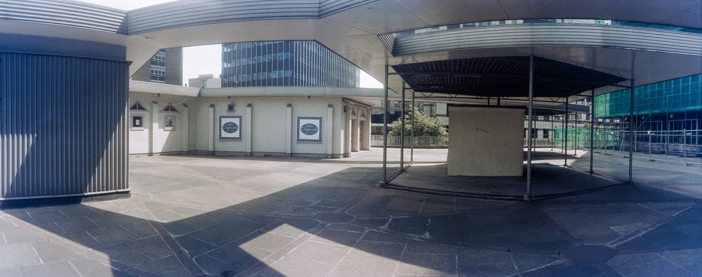
Around the Highwalks – Wood Street: London’s ambitious series of ‘highwalks’, aimed at separating movement on foot from traffic began after World War 2 when the City began to rebuild after extensive war damage – a process that really sprung into action on a large scale in the 1950s.

Highwalk, Wood St, City, 1994, 94-708-21

As Wikipedia states, “In 1947 architect Charles Holden and planner William Holford” had put forward a blueprint for “a network of first-floor walkways that would connect buildings across the City.”

Wood St, Escalator, London Wall, City, 1994, 94-709-12, 1994, 94-709-31
Wood St, Escalator, London Wall, City, 1994, 94-709-31

The City of London Pedway Scheme was later adopted by the City of London Corporation and to get planning permission by the 1960s all new developments were required to include first floor access to walkways. It worked where there had large areas destroyed by bombing – such as the Barbican, but elsewhere these walkways were often dead ends leading nowhere.

Wood St, Escalator, London Wall, City, 1994, 94-709-12

Although London had suffered greatly from the bombing, much survived – and many damaged buildings had been restored in the immediate aftermath of the war. Although some of the city’s older buildings were demolished there was an increasing recognition of the value of many of them. The 1944 Town and Country Planning Act had given the government power to create a statutory list of buildings of special architectural interest – and those powers were increased in the 1947 Act.

Green Cuisine, Highwalk, Wood St, London Wall Citry, 1994, 94-709-21

Listing of buildings began seriously after this, and many buildings in the City gained some protection from demolition – and a resurvey in 1968 began to add more to the lists. It became increasingly clear that the Pedway scheme would never be able to produce a really coherent scheme over most of the City and by the mid-1980s it was effectively discontinued.

Highwalk, St Alphage Highwalk, London Wall, City, 1994, 94-710-22

Since then some parts of the walkway system have been lost, while some areas still remain. Around London Wall while some parts of it were closed. The part of the St Alphage Highwalk in these pictures had been demolished but it was partly replaced by a new section during redevelopment around 2017.

Highwalk, St Alphage Highwalk, London Wall, City, 1994, 94-710-12

Another problems with the Pedway is that London’s transport systems – buses and Underground largely leave passengers at street level. Getting to the highwalks generally requires going up steps and most people would prefer to simply continue to their destination at street level.

Highwalk, St Alphage Highwalk, London Wall, City, 1994
Highwalk, St Alphage Highwalk, London Wall, City, 1994, 94-710-11

For those with disabilities which make steps difficult or impossible this is a real barrier. There were very few places where escalators were provided to ease the problems as these were expensive.

More panoramic images from the City Highwalks in a later post.


FlickrFacebookMy London DiaryHull PhotosLea ValleyParis
London’s Industrial HeritageLondon Photos

All photographs on this page are copyright © Peter Marshall.
Contact me to buy prints or licence to reproduce.


More City Panoramas – 1994

More City Panoramas: I spent several days wandering around the City of London – the “Square Mile” in July and August 1994, I think in prepaation for a group show in which I had decided this would be my contribution.

More City Panoramas - 1994
Bubbs, Restaurant Francais, Farringdon Rd, West Smithfield, City, 1994, 94-702-43

Bubb’s Le Restaurant Francais with the address Central Market, Farringdon Street is long closed, but a listing states that they served “a variety of traditional French dishes at their restaurant and can cater for private parties of up to 30 guests upon request.” There are still several French restaurants in the area.

A little further down West Smithfield was the London Central Market with on the corner a wholesale Cash and Carry and Harry’s Drinks and in the distance a covered way across the road between market buildings.

I photographed this corner on several occasions, making a similar panorama here in 1992, perhaps why I have not put this on Flickr.

More City Panoramas - 1994
River Thames, Thames Path, Vintners Hall, Paul’s Walk, City, 1994, 94-703-52

Looking west along the river to Bull Wharf, Queenhithe and beyond. Bull Wharf proudly states it was REBUILT 1980 and it looks to me exceedingly ugly, probably why I didn’t upload this picture to Flickr. My picture perhaps makes the red brickwork event more virulent – the building looks much better to me in a black and white non-panoramic image I made at the same time from more or less the same spot.

Car Park, Smithfield St, City, 1994, 94-704-51

Slightly out of focus in the distance I can just make out Lady Justice on the roof of the Old Bailey and to her right more clearly the tower of Holy Sepulchre Church at the east end of Holborn Viaduct.

I think this car park probably extended to Hosier Lane and is now filled with the shops and offices of 12 Smithfield Street, built in 2004 and now described on Buildington as “an outdated office block that has suffered from poor environmental performance, limited architectural merit, and inefficient servicing. Its ground floor lacks engagement with the surrounding public realm, and its dated façade no longer reflects the character of the conservation area” and being refurbished and extended.

St Mary Somerset Church, Upper Thames St, City , 1994, 94-704-13

A rather dark rendering of this high contrast scene with deep shadow the block of St Paul’s Vista (or 1 High Timber St, now One Millennium Bridge) straddles Upper Thames Street with the bright sky above. My picture was made from the footbridge of Fye Foot Lane carrying a section of the CIty’s Highwalk across Upper Thames Street and Castle Baynard Street and on to Queen Victoria Street.

St Mary Somerset Church was one of those destroyed in the Great Fire of London in 1666 and like 50 others rebuilt by the office of Sir Christopher Wren. The tower remains between Lambeth Hill and Castle Baynard Street but the rest of the church was demolished in 1871 when like other redundant churches the land was sold to build churches in the rapidly expanding suburbs of London. The tower was a Ladies toilet before the Second World War, Damaged by bombing, it was restored by the city in 1956 and has now been converted into a private residence.

More City Panoramas - 1994
Highwalk, Footbridge, Huggin Hill, Upper Thames St, City, 1994, 94-705-41

A fruit and vegetable stall on the pavement in Front of St Mary Aldermary (another rebuilt by Wren after the Great Fire) on busy Queen Victoria Street which you can see at extreme left. I think the extremely low stone wall on the pavement and the railings mark the former edge of its churchyard.

I liked the range of architectural age and style across the upper half of this image, and particularly admired the ornate Victorian block in the centre of the picture. As well as a bus and a coach there are 5 London taxis in the picture, an aspect of London’s traffic congestion long overdue for reform.

Highwalk, Footbridge, Queen Victoria St, City, 1994, 94-705-31
Highwalk, Footbridge, Huggin Hill, Upper Thames St, City, 1994, 94-705-31

This was taken from a now-closed section of Highwalk across Upper Thames Street and the church at left is St Mary Somerset. The alley at right is Huggin Hill with a view of the distinctive building on the block between Queen Victoria St, Bread Lane and Cannon Street, 30 Cannon St built for Crédit Lyonnais between 1974 and 1977.

Highwalk, London Wall, City, 1994, 94-706-51

So many buildings have changed around here since 1994. The building right of centre is Standard Chartered on the corner of Aldermanbury and Aldermanbury Square and was remodelled around 2010 and the building left of centre is Brewer’s Hall, now with a roof extension. I think this section of the highwalk led up at Brewers Hall Gardens

More from July 1994 in the City later.


FlickrFacebookMy London DiaryHull PhotosLea ValleyParis
London’s Industrial HeritageLondon Photos

All photographs on this page are copyright © Peter Marshall.
Contact me to buy prints or licence to reproduce.


More Around the City

Bassishaw High Walk, City, 1987 87-11c-16-positive_2400
Bassishaw High Walk, City, 1987

There is still a section of the pedestrian route above traffic level here, leading from the yard behind the Guildhall and to a bridge across London Wall, though the bridge is now a more recent construction a little further west and crossing at an angle and leading on to the high walks that were built into the Barbican Estate. This area next to City Tower looks rather different now. Britannic House, one of the original six towers built along the new London Wall was refurbished in 1990 and renamed City Tower.

Highwalk, Moor Lane, City, 1987 87-11c-21-positive_2400
Highwalk, Moor Lane, City, 1987

Looking down Moor Lane with the Barbican at the right on a section of the high walk that has now gone, but which used to lead from close to Moorgate station. I think this gateway was roughly above the junction with Silk St. Empty when I took this picture (possibly on a Sunday) it was sometimes quite crowded during the rush hours with office workers making their way to the tube. The high walks were useful routes, avoiding the often dangerous traffic on the streets and also providing good vantage points for photographers, and I’m saddened at their loss. But I think they took up space that could be sold expensively as offices.

Ropemaker St, Islington, 1987 87-11c-31-positive_2400
Ropemaker St, Islington, 1987, City

This building on Ropemaker St was one of my favourite examples of modern office architecture when it was built, and I photographed it on several occasions. I suppose it doesn’t quite belong in this post as it was on the north side of the road and thus in Islington rather than the City, where I was standing on a section of high walk to take the picture.

Ropemaker Place, a 60m high block was completed in 1987 shortly before I made this picture. It didn’t last long and was demolished only 18 years later in 2005.

Holland House, Bury St, City, 1987 87-11c-51-positive_2400
Holland House, Bury St, City, 1987

Holland House in Bury St has lasted rather longer and is protected by its Grade II* listing. The only London building by leading Dutch architect Hendrik Petrus Berlage it was built in 1916 for the Dutch company Wm H Müller & Co, complete with a granite prow by Dutch sculptor J. Mendes da Costa.

More recently when I’ve photographed here I’ve stepped a little to the left to bring the ‘Gherkin’ into view – but construction of 30 St Mary Axe only began in 2001.

Cutler St area, City, 1987 87-11c-53-positive_2400
Cutler St area, City, 1987

I think this is a part of Devonshire Square, a private area of the City which was developed by the East India Company, then sold to St Katharine’s Dock and bought in 1909 by the Port of London Authority. The warehouses here were used to store the more valuable commodities imported from across the empire. The site was acquired by Standard Life Assurance together with Greycoat Estates Ltd in 1978 and became offices, but still remained something of a private enclave, if no longer used for the secure storage of “Ostrich feathers, chinaware, oriental carpets, cigars, tortoiseshell, silks, mother of pearl, clocks, watches, cameras, drugs, spices, musical instruments, perfumes, tea and other prized artefacts.”

Baltic Exchange, St Mary Axe, City, 1987 87-11c-63-positive_2400
Baltic Exchange, St Mary Axe, City, 1987

The Provisional IRA left a van packed with explosives outside the Baltic Exchange in St Mary Axe shortly before 9pm on 10 April 1992, and then made a call to the police warning them that a bomb was about to explode at the Stock Exchange – 370 metres away in direct line, but about half a mile by road. The bomb wrecked this facade and caused a total of £800 million worth of damage to this and surrounding buildings.

Perhaps the bombers were confused and looking for the old Stock Exchange building in Capel Court, off Bartholomew Lane, just to the east of the Bank of England, while the Stock Exchange had moved in 1972 to a new tower on Old Broad St.

21 New St, Cock Hill, City, 1987 87-11c-55-positive_2400
21 New St, Cock Hill, City, 1987

This listed archway with a Merino Ram was built in 1863 for Cooper’s Wool Warehouse. By the 1900s the wool storage business had largely moved further east closer to London Docks and in 1907 the warehouse was sold and used for other storage. It was converted into offices in 1981.

Newsprint, Bouverie St, City, 1987 87-11d-01-positive_2400
Newsprint, Bouverie St, City, 1987

Some newspapers were still being printed in ‘Fleet Street’ and the picture shows a lorry delivering newsprint to one of the printing works on Bouverie St.

The Seven Ages of Man, Richard Kindersley, sculpture, Baynard House, Queen Victoria St, City, 1987 87-11d-41-positive_2400
The Seven Ages of Man, Richard Kindersley, sculpture, Baynard House, Queen Victoria St, City, 1987

This sculpture stands in front of one of London’s bleaker Brutalist buildings, and for once its hard to disagree with Pevsner over a modern building, when he describes this a “acutely depressing.” But it does include a section of high-level pedestrian walkway with seating and this rather fine sculpture based on ‘As You Like It’. And it’s a pleasant enough place to sit and read a newspaper with a view of St Andrew by the Wardrobe, the last city church rebuilt by Sir Christopher Wren after the Great Fire of London.

All from Page 7 of my 1987 London Photos.


All photographs on this and my other sites, unless otherwise stated, are taken by and copyright of Peter Marshall, and are available for reproduction or can be bought as prints.


1987 – In the City

St Botolph's Church Hall, Bishopsgate Churchyard, City, 1987 87-11a-15-positive_2400
St Botolph’s Church Hall, Bishopsgate Churchyard, City, 1987

St Botolph’s Church Hall in Bishopsgate Churchyard has changed little since I took this picture over 30 years ago and the churchyard is still a place you can stroll though away from the noise and fumes of Bishopsgate a few yards away.

Old Broad St, City, 1987 87-11a-21-positive_2400
Old Broad St, City, 1987

Back in 1987 you could walk through a considerable part of the City on the High Walks, pedestrian walkways above the streets, one of which could be accessed at the western end of Bishopsgate Churchyard and gave elevated views of the buildings on Old Broad St opposite. Boston House appears to be the name of the the block on Old Broad Street between London Wall and New Broad St, and to be made up of two similar buildings; this one, on the corner of London Wall appeared to me the more satisfactory.

Highwalk, view, St Botolph's Churchyard, City, 1987 87-11a-22-positive_2400
Highwalk, view, St Botolph’s Churchyard, City, 1987

This was the view from the highwalk looking back down Bishopsgate Churchyard. Much of the the highwalk has since been closed to the public.

Highwalk, View, Old Broad St, City, 1987 87-11a-24-positive_2400
Highwalk, View, Old Broad St, City, 1987

Perhaps surprisingly this view from the north end of the highwalk looked little different until recently, though I don’t think there is any public access to enable you to see it from my 1987 viewpoint. At far left is the corner of Broad Street Avenue and the building, 76-80 Old Broad Street, dates from around 1860 and is Grade II listed. The UBS building at 100 Liverpool St was completed in 1988, but UBS moved out a few years ago (to an even more hideous building in Broadgate, nominated for the Carbuncle Cup) and others moved in, but the building has been treated to a facelift, with a new skin over the old structure.

Highwalk, View, London Wall, Old Broad St, City, 1987 87-11a-34-positive_2400
Highwalk, View, London Wall, Old Broad St, City, 1987

Although the bridge across Wormwood Street from which I took this picture is still in place (or was last time I walked by before lockdown) the stairs leading to it were firmly blocked. It shows the junction between Old Broad St and the east end of London Wall, with Boston House, shwon in a picture above, on the corner at right.

Angel Court, City, 1987 87-11a-41-positive_2400
Angel Court, City, 1987

Angel Court is an alley in the centre of London’s finanacial district between Throgmorton St and Copthall Avenue, now leading between tall buldings.

Throgmorton Gardens, City, 1987 87-11a-43-positive_2400
Throgmorton Gardens, City, 1987

A little to the east of Angel Court, this garden is at the corner of Austin Friars and Copthall Avenue and was I think closed to the public, and my photograph was taken through the fence looking south from Austin Friars.

More from the CIty of London in a later post. All these pictures are in my Flickr album 1987 London Photos.


All photographs on this and my other sites, unless otherwise stated, are taken by and copyright of Peter Marshall, and are available for reproduction or can be bought as prints.