Islington, Charlton & Refugees: On Saturday June 19th 2005 I photographed Imagine Islington, a green festival in Islington, then went out to Charlton for the Horn Fair, before finally returning to central London for a Refugee event taking place as a part of the Coin Street Festival in Bernie Spain Gardens on the South Bank of the Thames in Lambeth. Again I’ll give the texts I wrote at the time with links to more pictures from the events on My London Diary.
Imagine Islington
Islington
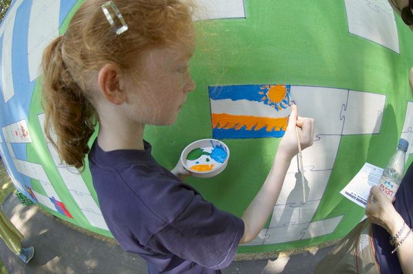
Painting the ‘Hugh Jart’ mural on Islington Green
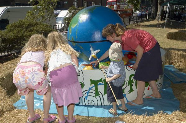
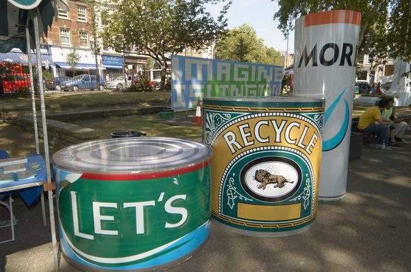
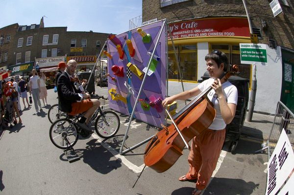
Imagine Islington was another green festival, but with rather more fun than some, taking place at 7 locations around the Angel and Islington Green.
Rhythms Of ResistanceWeapons of Sound, playing a range of containers, trolleys and other objects
On the Green there was music from Rhythms Of Resistance and Weapons Of Sound, a giant mural to paint by ‘Hugh Jart’, an air-miles game and other attractions.
The food miles interactive game from ‘Arts Desire’ was designed to show the high cost in carbon emissions of importing fruit and veg
Elsewhere there was a wind installation at St Mary’s Church, a Biodiversity Garden in the NI Centre, the Incredible String Trio Pluck (they described themselves as “the world’s most musically challenged string trio“) in Chapel Market and more.
Recycling is fine, but there needs to be more emphasis on reusable containers and on simply consuming less and wasting less.More Pluck in Chapel Market
This was a pleasant event for the family but largely concentrated on the froth rather than the essentials of the challenge the world faces.
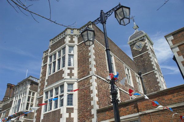
I wanted to go to Charlton simply because the annual Horn Fair there was notorious for its “indecencies and frequent riots“, eventually leading to its suppression by an order in council in 1872.
Irish dancing
Unfortunately its modern recreation turned out to be a much more tame affair, although Charlton House remains impressive.
[I also took a few pictures on my journey to Charlton and on my way from there to Coin Street, some also included in my 2006 post.]
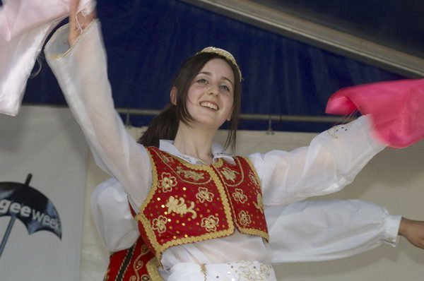
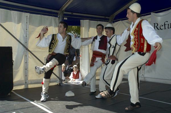
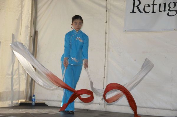
Meanwhile in Coin Street, another Refugee Week event, Celebrating Sanctuary, was taking place.
The men’s dance was more energeticThis Chinese dancer made some great patterns with her long streamersThen we had a fantastic performance by a large group of all ages from Uganda, in various tribal dress and a great deal of energy
Among the events I photographed were Albanian dancing, a Chinese dancer with long streamers and African dancing from Uganda.
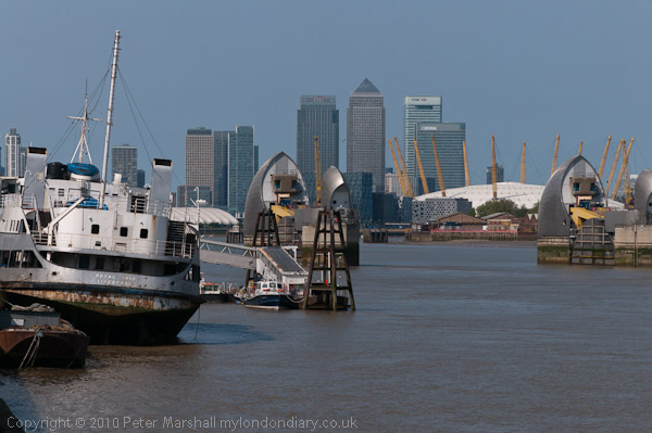
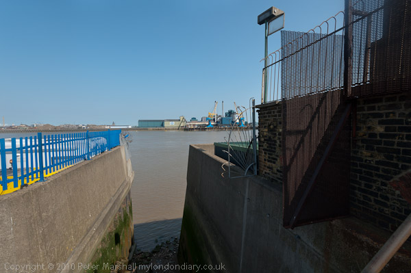
The view upriver from Charlton with the Thames barrier, Dome and Canary Wharf
Charlton to Belvedere: On Monday 25 April 2011 I went with my wife and elder son on a walk from Charlton Station to Belvedere. They walked but I rode on my folding Brompton bike as I was still suffering from plantar fasciitis and walking any distance became too painful.
A derelict pub in Charlton
As a cyclist any pressure is on the ball of the foot, with no weight at all on the heel and arch where the pain can be intense. Gel insoles help a little for walking and I was still managing to photograph events, but longer – and faster – walks were still completely out of the question for me.
Tate & Lyle in Silvertown
I’d been to see my doctor who was sympathetic and told me that physiotherapy might help, but given the waiting list for appointments the pain would probably have gone away before I got one. But there were exercises that could help – and after I had spent a few months rolling a baked bean tin back and forth under my heal while having breakfast the pain did eventually go away.
Warspite Rd/Bowater Rd SE18
The bike was a great idea. Linda and Sam were fast walkers and intent on getting to our destination, while as a photographer I kept stopping and sometimes wandering a little to one side to get into the right position to take pictures. Then I would see them a couple of hundred yards ahead and would need to run to catch up. So much easier on the bike.
I took advantage of my bike to make some longer than normal diversions, at one stage cycling down a road to reach the river where there was no riverside path but riverside steps. I had a scary moment here, walking out on a ledge to get a better view I lost my balance and began to shake uncontrollably in front of a 10 foot drop onto the concrete steps and rubble of the foreshore. Fortunately I managed instead to grab hold of a rail behind me and after holding it for a few seconds steady myself enough to edge back to safety. I was only too aware of a history of photographers falling to their deaths while ‘getting a better view’.
Recent flats on the former Royal Dockyard at Woolwich
Eventually I stopped shaking and was able to get back on my bike and hurry after the others. And no, I didn’t tell them what had happened and they still won’t know about it unless they read this.
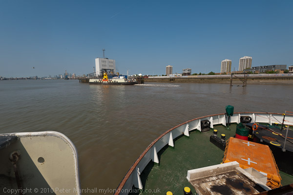
We were on the John Burns, named after the great trade unionist and Labour politician who called the Thames ‘liquid history’.
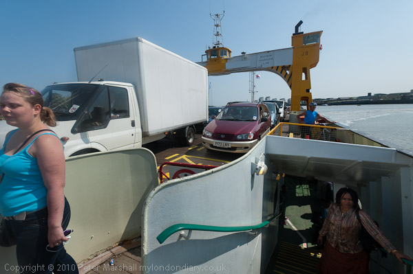
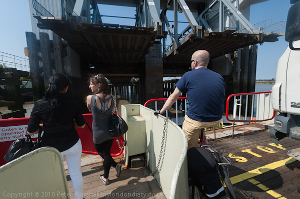
At Woolwich we took a ride across on the Free Ferry. Folding the Brompton I could walk past the ‘No Bicycles’ sign and go below deck with the others. I’d hoped we could return by the tunnel, but it was closed so we had a short walk in North Woolwich and a second ferry ride.
Coming back to Woolwich I kept on the vehicle deck. Bikes get to ride off before the cars.
When the Thames Path was declared a National Trail and then opened in 1996 it ended at the Thames Barrier. Our walk in 2011 began at Charlton station so only the first short section was on that and beyond we were walking the Thames Path Extension. I had previously walked all of this route, and further on as far as Cliffe. If you have the stamina you can now continue all the way to the Isle of Grain though a bike would really be a good idea. Perhaps one day I’ll do it.
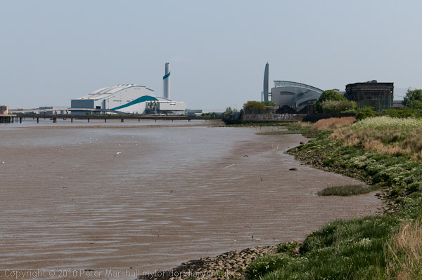
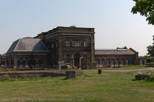
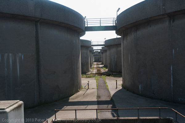
The Royal Arsenal site, once an official secret is now a tourist destination, complete with various sculptures, including Peter Burke‘s AssemblyThere are glimpses of the river and these waste transfer barges though trees and over bushe and Beckton on the opposite bankOne of the larger tributaries of the Thames is the treated outfall from Beckton sewage works at left. close to Barking CreekWaste incinerators and the Bazalgette pumping stationThe Romanesque Crossness Southern Outfall Works opened in 1865, pumping sewage out when the tide would take it seawardsPart of the more utilitarian 1950s sewage treatment plant at CrossnessThe 1998 sludge incinerator, an elegant swan-like metal structureLooking downstream to silos at Rainham
On this ‘walk’ I gave up here and cycled to Belvedere station to get home for a meeting in the evening, while the two walkers continued to the Darent and then walked back to Slade Green station.
Many more pictures on My London Diary from the walk and the ferry at More Thames Path.
Springfield Grove estate, Charlton Rd, Charlton, Greenwich, 1990, 90-1j-62
This estate was built on what had earlier been the site of the late 17th Century Springfield House, which was demolished just before the Second World War – the LCC had bought Stonefield Farm in 1927 for the Thornhill Estate. During the war there was a pig farm on the site. Springfield House took its name from a spring here which ran down in a valley here when the house was built. and though it is sometimes described as a wooded combe (dry valley) construction of the estate was held up in 1949 by the spring having to be stemmed and the ten blocks date from 1951-2.
The blocks were named with associations to previous Lords of the Manor of Charlton “Bayeaux – Bishop Odo of Bayeaux ; Downe & Ducie – Sir Wm.Ducie created Vise.Downe ; Erskine – Sir John Erskine Games – Wm.Langhorn Games ; Langhorne – Sir Wm.Langhorn, Mar – Earl of Mar (Sir J.Erskine) ; Priory – Priory of Bermondsey and Wilson – Sir Thos. Wilson 6th Bt. who married into the Maryon family, owners of the Manor & Estates.“
These ten brick LCC point blocks in the Sparingfield Grove Estate (also known as Thornill Estate which it adjoined) were built around 1950, and the view between the towers here is described in the conservation area document as the most dramatic of the “number of good panoramic vistas” from the escarpment here, with a view towards the Thames and central London. The estate was built by the LCC but was transferred to the London Borough of Greenwich when that was set up and then in 1999 to a housing association. In 2012 the blocks were clad hiding the brickwork, which although I think is aesthetically poorer will have been much appreciated by residents for increasing their comfort.
I walked along here, but perhaps the best way to appreciate the views is from the upper deck of a bus going along Charlton Road or Charlton Church Lane.
War Memorial, Drinking Fountain, Public Toilets, Charlton House, Charlton Church Lane, The Village, Charlton, Greenwich, 1990, 90-1j-54
The triangle in the middle of the junction between Charlton Church Lane and The Village would, apart from the traffic be a pleasant place to sit and there is now a seat between the war memorial and the drinking fountain, though I think you need to bring your own drink. Most of our old drinking fountains have been disconnected for hygienic reasons, though London does now have some new ones. At least in winter you can see a wide variety of architecture, though trees tend to block some views for the rest of the year.
The cattle trough which replaced the old village stocks must I think have been just out of my picture on the left and like the drinking fountain was erected to commemorate the coronation of King Edward VII in 1902, together costing £247 donated by local residents and Sir Spencer Maryon Wilson, 11th Bart – who gets his name on the side of the trough. The fountain was damaged in 1980 when a driver without tax or licence drove into it; Greenwich Council decided they could not afford the £3,000 needed to repair it, but local residents again reached into their pockets.
Charlton House, The Village, Charlton, Greenwich, 1990, 90-1j-66
Charlton House is said to be the “finest Jacobean mansion in all London”, designed by architect John Thorpe, said to have been the inventor of “humble and now-ubiquitous corridor” which allowed independent entrance to the various rooms of a grand house – previously each room had led through doors to the next in what was know an an enfilade.
The house was first opened to the public in 1909 with the one shilling (5p) entry fee going to provide free lunches for the children of Deptford. Now in public ownership for 100 years it is one of the few things that cost less than then, with house and grounds free to the public.
The large classical arch was once the entrance to the grounds but is now isolate, all on its own in a large area of grass.
Part of the house was badly damaged by wartime bombing in 1944 but has been carefully restored, and perhaps the only visible sign is a slightly lighter colour to the bricks used – and apparently the sundial between the first and second floor windows was fitted upside down.
The house was built by the crown for Prince Henry, the son of James I, and older brother of the future Charles I and his then tutor, Sir Adam Newton who was Dean of Durham, though hardly convenient for him as the 260 mile commute would then have taken several days. But I imagine he could claim his salary while working from home despite there being no internet connection.
The house has a grandly decorated doorway.
Roman Stone, Acorn, Charlton House, Charlton, Greenwich, 1990, 1990, 90-1j-45
Charlton was of course long famous for its Horn Fair, held not at Charlton House on the top of the hill but at Cuckold’s Point on the River Thames. It was described by Daniel Defoe as a “yearly collected rabble of mad-people” which “ought to be suppressed, and indeed in a civiliz’d well govern’d nation, it may well be said to be unsufferable” and at which “the women are especially impudent for that day; as if it was a day that justify’d the giving themselves a loose to all manner of indecency and immodesty, without any reproach“.
And in 1872 it was suppressed but a considerably “tamer version of the fair was re-established in 1973 in the grounds of Charlton House“. I went at least once and was disappointed, particularly by the lack of female impudence.
The ‘Roman Stone’ is not of course Roman, but an artificial stone probably bound together with Portland Cement (invented by Joseph Aspdin in 1824) much used for garden ornaments in the Victorian era and beyond. These materials can be moulded using sand moulds.
Woodland Terrace, from Maryon Park, Charlton, Greenwich, 1990, 90-1j-25
Woodland Terrace is in what was a large wooded area known as Hanging Woods which hung on the side of the slopes rising from the River Thames here. The main Dover Road runs through these woods and Shooters Hill was a popular haunt for highwaymen, though less popular for travellers. Hanging Woods was a wild wooded area good for the gentlemen of the highway to hang out and evade pursuit.
Maryon Park, Charlton, Greenwich, 1990, 90-1j-11
Maryon Park is a former quarry, part of Charlton sandpits on the edge of Hanging Wood, which the Maryon-Wilson family gave to the LCC in 1891. The sandpits were dug in the 18th and 19th centuries for sand in the local foundries and for making glass, and there were also chalk pits nearer to the river. One of the four pits, Charlton Station Pit is now The Valley, home to Charlton Athletic Football Club, and another, Gilbert’s Pit, is part of a nature reserve. The East Pit is Maryon Park, along with an un-quarried ridge on its west side.
Maryon Park, Charlton, Greenwich, 1990, 90-1j-15
On the Charlton Parks Reminiscence Project you can read a great deal about the history of the park which was opened in 1890. Serpentine fenced paths lead down from Woodland Terrace to the floor of the park below. The park’s moment of fame came in 1966 with the filming there in Michelangelo Antonioni’s ‘Blow Up‘ featuring David Hemmings, and Vanessa Redgrave. A YouTube video ‘Blow Up Revisited‘ intercuts scenes from the film with those taken in the same areas of the park in 2010.
I’d photographed the park in 1985 and in 1990 only too a few pictures of some of the fences before rushing to the station to catch a train towards home.
Around Shooters Hill Road: Continuing my walk on Saturday 20th January 1990 which began with the previous post, Westcombe Park and Blackheath 1990.
Heath House, 1 Shooters Hill Rd, Greenwich, 1990, 90-1i-34
This is an area full of mostly large houses, and this, at 1B Shooters Hill on the corner of Vanbrugh Terrace – the A2 ancient main road Watling Street from London to Dover via Canterbury – is one of the larger and is extended by the substantial conservatory.
According to its Grade II listing it was “built by Benjamin Cooke the cooper and shipowner of Dock Head, Bermondsey, about 1850” though the glazed conservatory was a later extension.
House, 19, Shooters Hill Rd, Greenwich, 1990, 90-1i-21
One of a long line of large houses on the north of Shooters Hill Road Grade II listed as 7-33 Shooters Hill Road. The listing is rather vague about dates, stating “2nd quarter of C19” and is mainly about the relatively minor differences between the pairs of houses mentioning the extra windows of 19 and its pair 21 at each side of the tympanum – probably why I chose this pair as one of two I photographed (the other not online.)
Houses, Stratheden Rd, Greenwich, 1990, 90-1i-24
I turned northeast from Shooters Hill up Stratheden Road, to photograph this impressive row of late Victorian large semi-detached houses leading up to St John the Evangelist Church. Two of the blocks at 15-17 have been joined with a new central entrance as Bardon Lodge.
St John the Evangelist Blackheath was designed by Arthur Ashpitel (1807–1869) in a largely Perpendicular style and was completed in 1853. It was built as a landmark to be seen from the west as the centre of the Vanbrugh Park development and is Grade II listed.
House, St John’s Park, Greenwich, 1990, 90-1i-26
This house immediately to the south of St John’s Church in St John’s Park was then surrounded by far more overgrown vegetation than now. There are two similar detached houses here and this is No 32. I saw it as a villa in some Gothic mystery – and may have deliberately chosen the viewpoint to exaggerate this.
These two detached villas are both locally listed and were built in 1873.
House, Vanbrugh Park, Shooters Hill, Greenwich, 1990, 90-1i-11
I’m rather surprised I didn’t photograph the rather fine pub on the corner as I turned from Stratheden Road into Vanbrugh Park, but my next frame was of these three storey houses at 30 and 31 Vanbrugh Park – there is another pair to their left.
I think these are probably late Victorian, built after many of the others in this street.
House, 90, Shooters Hill Rd, Charlton, Greenwich, 1990, 90-1i-14
Originally this was a semi-detached house, but the left half was lost with the construction of the ‘Sun in the Sands’ roundabout to take Shooters Hill Road over the the Rochester Way Relief Road which opened in 1988.
Rathmore Benches & Greyladies – New Charlton 1995: You can still see these mosaic decorated concrete benches on Troughton Rd and around the corner in Rathmore Rd. A short walk from Charlton Station, the building they are outside has for some years been the New Covenant Church Charlton.
Rathmore Community Centre & Rathmore Benches (Former Good Shepherd Mission Hall), 61a, Troughton Road, New Charlton, Greenwich, 1995, 95c5-714
The mosaic covered benches were installed here together with a mural on the walls behind in 1980. By 1995 the mural had been painted over but the benches remained, still in fairly good condition.
Rathmore Community Centre & Rathmore Benches (Former Good Shepherd Mission Hall), 61a, Troughton Road, New Charlton, Greenwich, 1995, 95c5-713
The benches were created as a part of a ‘Past, Present and Future of Charlton‘ project with the help of adults and children from the community centre by Greenwich Mural Workshop, who got funding to restore them in 2019 as they had suffered from wear and tear and some vandalism.
Rathmore Community Centre & Rathmore Benches (Former Good Shepherd Mission Hall), 61a, Troughton Road, New Charlton, Greenwich, 1995, 95c5-835
On the For Walls With Tongues web site of Greenwich Mural Workshop you can see pictures of the missing mural as well as the benches and learn more about their creation.
Rathmore Community Centre & Rathmore Benches (Former Good Shepherd Mission Hall), 61a, Troughton Road, New Charlton, Greenwich, 1995, 95c5-834
The centre had been built as the Good Shepherd Mission Hall and the Greenwich Local Heritage List states it is a 200-seater mission hall built 1900 to designs of architect J Rowland and was developed from Holy Trinity Mission run by Greyladies College.
Rathmore Community Centre & Rathmore Benches (Former Good Shepherd Mission Hall), 61a, Troughton Road, New Charlton, Greenwich, 1995, 95c5-833
Greyladies College for Women Workers was based in Dartmouth Row , in “a delightful country house, once the mansion of Lord Dartmouth, and stands on the breezy heights of Blackheath, in the midst of its own beautiful grounds, and with far-stretching views over the surrounding country to the Crystal Palace.“
“The great aim of the Greyladies’ College is to bring together lonely women working in isolation without a definite plan, and also women who are possibly daughters in a large family and find it difficult to separate themselves from social distraction in order to follow religious and philanthropic work.“
The Greyladies worked in 22 parishes in South London “helping in the work of the Church of England under the incumbents of the diocese.” The description of them in Volume 1 of Every Woman’s Encylclopaedia published in 1910-12 is fascinatingly and charmingly dated.
New Charlton in Colour – 1995. New Charlton has now been given the new and more descriptive name of Charlton Riverside and is the area between the River Thames and the main road from Greenwich to Woolwich, Woolwich Road. The major feature of the area other than the river is the Thames Barrier, but although I photographed this in black and white it does not appear in my selection of colour pictures. I had photographed it in black and white and colour on several occasions since 1984 from both sides of the river and so felt no need to visit it again in 1995.
Eastmoor St, New Charlton, Greenwich, 1995, 95c5-743
I did find a very different barrier on Eastmoor Street, with this monumental slab apparently cut out to leave a gateway through this reflective red wall. Whatever its original purpose – I think perhaps an art work – it seemed to have served for target practice probably for bricks thrown by local youths.
Classic Car Restorations, New Charlton, Greenwich, 1995, 95c5-733
And I did photograph Thames Barrier Classic Car Restoration with its texts and pictures of cars on its wall.
Carpet Kingdom, New Charlton, Greenwich, 1995, 95c5-732
The redevelopment of the area had begun when the Thames Barrier was opened, but much was still industrial or derelict but large parts are now occupied by large retail units. Carpet Kingdom was one of the first to open, though I don’t remember exactly where. There is now a rather larger Carpet Giant in the area,
You can still see this giant mural, details from which are in my two pictures. It was painted on the wall of this house in 1976 by the Greenwich Mural Workshop in 1976 and has now faded considerably.
Mural, Charlton, Greenwich, 1995, 95c5-725
Just south of the railway line close to Charlton’s ground at The Valley and so in Charlton rather than New Chalton, I had glimpsed it in my journeys past on the train and so went to photograph it.
Annette, Hair Stylist, Valley Grove,Charlton, Greenwich, 1995, 95c5-724
Annette Hair Styling was just around the corner from the mural in Valley Grove, so also in Charlton rather than New Charlton.
Thursday I did another photographic ride, quite a lot on various footpaths and exploring small park and woodlands, more than covering my ten miles but at a more leisurely pace. The temperature was well up in the twenties and there was little or no wind and it got very hot in the sun. The pictures here come from this ride.
It was too hot on Thursday night for me to sleep well and I woke on Friday not feeling at my best, with a slight stomach upset and feeling just a little chesty. It was a pleasant temperature – 19 degrees – but rather windy as I set out at 10am for my exercise ride. Wind is a pain for cyclists though it helps to have it behind you but it always seems to be more of the time against, and adds to the effort. I’d decided on a route through some back streets and I got lost, ending up in a dead end behind some houses.
I stopped and got the map out, and found I had cycled too far up a hill and would have to go back around 600 metres. Next I had problems with my gears, finding a very steep short rise and being unable to change down to my lower set on the smaller chain wheel, and coming to a halt. Eventually I managed to move the chain, but made several unsuccessful attempts to start of the steep rise before having the sense to ride across to get started. I struggled up, and at the top simply collapsed. My heart was racing, I was panting heavily for breath and felt slightly sick and rather shaky, and I had to keep sitting on the pavement for around five minutes before I felt well enough to get up.
I thought about giving up and turning for home, but decided since the hill ahead wasn’t as steep and I’d now got my gears more or less sorted to try to carry on. I crossed the main road and struggled on up the hill until I was more or less at the top and then stopped. I was still feeling pretty rotten and decided there was no point in carrying on. I turned around and made for home by a slightly more direct route. For the first half mile I didn’t even have to pedal. But I didn’t quite make my ten miles, just a little over seven before I reached home for a rest on our sofa.
Perhaps I will have to rethink my exercise schedule, though it may be enough just to make myself take it a little easier on the hills and give up and walk rather than forcing myself to ride. It would be easy to avoid hills altogether by staying in south-west Middlesex, one of the flattest areas of the country. All the hills here are man-made, railway and motorway bridges and a little over-generous infill of some gravel sites and none present a great challenge to even elderly cyclists.
All photographs on this and my other sites, unless otherwise stated, are taken by and copyright of Peter Marshall, and are available for reproduction or can be bought as prints.
In 1984, I more or less came to an end of my work on the River Lea (though I returned to it later) and the major focus of my photography shifted to London’s Docklands, and I’d photographed the West India and Millwall Docks as well as the Royal Docks, pictures from which I’m currently posting daily on Facebook. And later in that year I also went to the Surrey Docks, where work by the London Docklands Development Corporation was well advanced.
I was very aware of the political dimensions of the redevelopment, with the LDDC taking over from the elected local authorities and imposing its own largely business-led priorities which although accelerating the development distorted it away from the needs of the local area, and particularly away from the still pressing need for more social housing and for better employment opportunities for local people.
In those years I read every book in my local library on the history and geography of London, and began to build up my own collection of older works bought from secondhand bookshops and by post. Before the days of on-line listings I used to receive a monthly duplicated list of books on offer from a dealer I think in Brighton, and found many topographic and photographic items of interest, often very cheaply, and would look forward to receiving heavy parcels wrapped in several layers of newspaper. Yes, there was mail order before Amazon, and it was rather more exciting.
It was reading one of the books, Donald Maxwells ‘A pilgrimage of The Thames’, published in 1932 with his imaginative text and evocative drawings (some originally printed in the Church Times) that prompted me to walk in 1985 as he did from Gravesend west through Northfleet and Greenhithe exploring what he christened ‘the Switzerland of England’. As a rather more down-to-earth guide I also had the more academic ‘Lower Thameside’ picked up for pennies in a secondhand bookshop, which included a chapter on its 1971 cement industry by geographers Roy Millward and Adrian Robinson.
My series of walks traversed what was an incredible industrial and post-industrial landscape, altered on a huge scale by quarrying and industry, continuing past Gravesend along the riverside path past Erith and Woolwich to Greenwich and Deptford (areas also covered in my 1985 London Pictures), as well as walking further east to Cliffe and Cooling.
It was a project that I returned to for several years – and I went back to the area more recently when the Channel Tunnel Rail Link was being built as will as the occasional walk or bike ride over the years.
All photographs on this and my other sites, unless otherwise stated, are taken by and copyright of Peter Marshall, and are available for reproduction or can be bought as prints.
There are no adverts on this site and it receives no sponsorship, and I like to keep it that way. But it does take a considerable amount of my time and thought, and if you enjoy reading it, please share on social media. And small donations via Paypal – perhaps the cost of a beer – would be appreciated.