Posts Tagged ‘River Hull’

Hull Colour – 6

Friday, July 17th, 2020
Barges on River Hull and Croda works, Hull 81-04-Hull-030_2400
Barges on River Hull and Croda works, Hull 1981

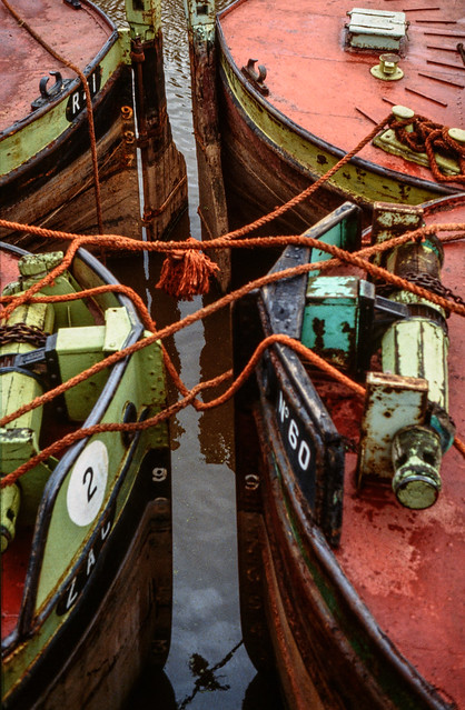
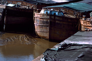
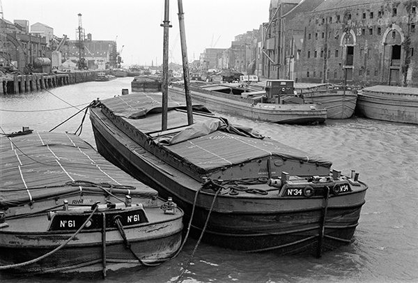
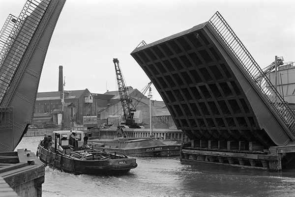
A busy scene on the River Hull, probably taken in 1981, though the dates on these images come from the album they are filed in and are sometimes not the exact year, and this could possibly have been made earlier.

The slide mount crops the image slightly and I’m sure that the actual transparency will have included the top of the water tank on the Croda silo at the Isis Oil Mills, but it would have greatly slowed down the photographing of this and the other slides to have removed the slides from their mounts – and would have made handling them much more tricky. And the macro lens and bellows combination I was using with the older Nikon slide holder was fine for mounted slides but could not give proper coverage of the full 24x36mm.

Perhaps because of the problem of slide mounts, many SLR cameras, though marketing on the benefits of actually viewing through the taking lens rather than the separate optics of the rangefinder Leica or twin-lens Rolleiflex had viewfinders that cropped the images and were actually less accurate in their framing than the Leica. Though even the Leica white line frames never quite exactly represented the area that would appear on film (though some lenses came very close) making something of a nonsense the insistence of many photographers of printing the edges of the negative to give a black frame because this represented how they had seen the picture when they pressed the button. It was always more an aesthetic decision.

The silo was still there last time I walked along Bankside, but the location from where I took this picture was behind a locked gate and the buildings to the right of the silo had gone and there was only one vessel, Cargill’s edible oil tanker Swinderby, moored along this reach of the river.

Works, River Hull 81-04-Hull-032_2400
Works, River Hull 1981

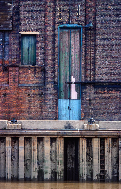
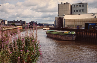
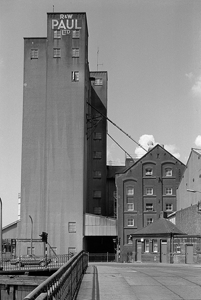
I can’t remember now where I took this picture of a wharf across the RIver Hull, somewhere in Hull. But I do remember being attracted by what appears to have been built as an incredibly tall doorway, though it does now appear to have been blocked by a pipe that emerges through it at a little under half its height.

Was it, I mused, made for giraffes?

542 Hessle Rd and phone box, Hull 81-04-Hull-034_2400
542 Hessle Rd and phone box, Hull 1981

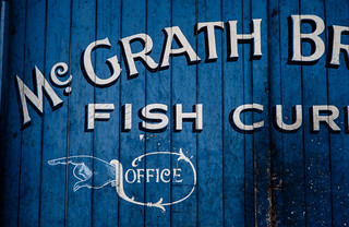
Hull Corporation was one of 55 local authorities to bid for a licence to provide telephone services in their local area in 1902 and opened its first telephone exchange in a former public baths two years later. While other local authorities who had been granted licences soon abandoned or failed, Hull continued its service after the Postmaster General had gained a monopoly elsewhere across the country.

And when in 1936 the Post Office launched a new red phone box designed by Sir Giles Gilbert Scott to commemorate the Silver Jubilee of King George V and decided that all phone boxes across the country should be red, Hull decided while adopting the new design to keep their traditional colour of cream and green, eventually moving to all cream. Hull City Telephone Department continued to innovate – and introduced a message from Santa in 1952. The council hived off the service into a fully owned separate company, Kingston Communications (HULL) PLC in 1987, which was floated on the Stock Exchange in 1999. In 2007 Hull Council sold its remaining stake in the business which changed its name to KCOM Group PLC.

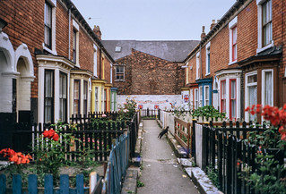
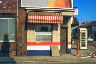
The scene on Hessle Rd is still recognisable, but the shop has changed and no longer has the colour scheme and awning that attracted my attention, and although there is still a phone box I think it may have moved a few feet.

Lincoln Castle, Hessle Forshore, Hessle 81-04-Hull-039_2400
Lincoln Castle, Hessle Forshore, Hessle 1981

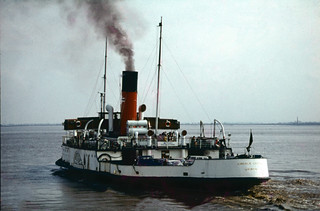
The paddle steamer Lincoln Castle was now beached on the Humber foreshore at Hessle, close to the Humber Bridge, and was now a restaurant where we went for afternoon tea. I made it into a rather strange landscape of distant jagged hills in this picture.

Humber Bridge, from Barton on Humber82hull135_2400
Humber Bridge, from Barton on Humber 1982

And of course we went across the Humber Bridge which took us to Barton-on-Humber. Where we walked around a bit and found there wasn’t a great deal there. I took a few photographs, mainly of the Humber Bridge, and I rather like this almost monochrome view.

More pictures on Flickr in Hull Colour 1972-85.


All photographs on this and my other sites, unless otherwise stated, are taken by and copyright of Peter Marshall, and are available for reproduction or can be bought as prints.


Hull Colour – 5

Thursday, July 16th, 2020
Wilmington Bridge, Hull 80hull102
Wilmington Bridge, Hull 19802

I’ve photographed this listed railway swing bridge across the River Hull many times, but I like this particular detail image not just because it gets away from a more standard view and for its colour, but because of the way it puts the bridge into its now largely gone industrial context.

The bridge was built to carry the lines from Hull east to the two North Sea seaside towns of Hornsea and Withernsea. Coming out from Hull Paragon the line turned north to a level crossing at the end of Spring Bank, close to the junction of Princes Avenue. Next to this was Botanic Station, where my wife in her youth would catch a train to Hornsea for the family’s annual week at the seaside. The line then swung east to Stepney Station, close to Stepney Lane on Beverley Road and then on to this bridge across the RIver Hull. The lines to Withernsea and Hornsea diverged on the other side of the river.

Sadly, Dr Beeching, an firm evangelist for the car and the motor trade, put an end to all that and both lines closed to passenger services in October 1964, a few months before my first trip to Hull. Goods services continued to use the bridge and track as far as Hedon until 1968, and all too often I found myself sitting on the top of a bus waiting for the crossing gates to open. In front of me during the evening rush hour then would be hundreds of men on bicycles on their way home.

Nowadays the bridge seldom swings for traffic along the river, though it remains in working order and will do so when necessary. And although there are no trains, the bridge is still in use for cyclists and pedestrians.

Sculcoates, Hull 80hull132
Sculcoates, Hull 1980

An evening glow lights up this view of Sculcoates, with the cabin of the Wilmington Bridge at its right-hand edge and the tall silo of the British Extracting Company Ltd at its left. I’ve not been able to find out why the water tank on its roof has a logo with a crown on top of a stylised letter R – please let me know if you know.

I think this view is from the embankment of another disused railway line which took the Hull, Barnsley and West Riding Junction Railway and Dock Company line to its Hull terminus at Cannon St. This had been intended simply as a goods station, but the company (later more simply known as the Hull and Barnsley railway) ran out of money to construct a passenger station closer to the city centre. The line which ran here on the west side of the Beverley and Barmston Drain was a short spur down from Beverley Road Junction on the line still in use for traffic to the eastern docks.

Barges in Old Harbour, Hull 81-04-Hull-020_2400
Barges in Old Harbour, Hull 1981

Another view of barges moored in the Old Harbour of the River Hull, secured to each other by some bright orange ropes. I’m sure that some of my more imaginative psychogeographic friends would see it as some kind of weird psychic circuitry.

Red Doors, Pattern Store, Hull 81-04-Hull-022_2400
Red Doors, Pattern Store, Hull 1981

I like the idea of a ‘pattern store’. If you ‘Google’ it you will mainly get sewing patterns, but I think this one will have been at some kind of engineering works. Patternmakers were particularly important in shipbuilding, railway works and foundries, and the patterns they made were usually wooden cut-out shapes which recorded the exact size and shape to which metal had to be cut or cast for a particular purpose. Pattern stores might also be used to hold plans and drawings.

McGrath Bros, Fish Curers, St Mark's Sq, St James Street, 1981 81-04-Hull-023_2400
McGrath Bros, Fish Curers, St Mark’s Sq, St James Street, 1981

Unlike the previous picture which I have no idea of where I took it, I can locate this painted gate fairly precisely to St Mark’s Square. Off St James’s St, which is off the Hessle Rd, this bears little resemblance to its Venetian namesake, but is rather more accurately a square, though only two sides carry its name.

McGraths, later ‘Shears (McGraths)’ was a member of the HULL Fish Merchants Protection Association, and although the Cod Wars had more or less killed Hull’s fishing industry, when I took this picture the auctions at the fish dock were still the largest fresh fish auctions in the country, handling over two thirds of our Icelandic fish imports as well as the smaller amounts landed by trawlers still operating from Hull and fish brought by lorry from other ports. Hull got a new state-of-the-art fish fishmarket in 2001, but in 2011 Icelandic fish agent Atlantic Fresh abandoned Hull’s Fishgate for Grimsby.

I love the pointing hand with its flourish directing the reader to the company’s Office.

Barge Torcha and River Hull, Bankside, Hull 81-04-Hull-028_2400
Barge Torcha and River Hull, Bankside, Hull 1981

I read the name of the barge incorrectly from a black and white version of this picture as it is TORCHA and not TORCH , but here is what I wrote about it.

A little downstream from the Hull Exhaust Centre, visible at left was another viewpoint, I think from a derelict wharf on the River Hull. This image, looking upstream, shows barge Torch, with number 22, owned by Hull’s Gillyott and Scott, a major tug and lighter owner formed in 1964 by amalgamation of the five companies of William Gilyott, John A. Scott, T.F. Wood, Furleys and John Deheer. Gilyott and Scott (Transport) Ltd also owned lorries. The barges are said to have been sold to Dave Hornshaw of Hornshaw Water Transport in Goole.
 
The buildings on the East bank are some of those on the Morley Street ultramarine works, then still part of Reckitt’s – with Hull’s tallest chimney a little out of the frame to the right. Most or all have now been demolished.

Torcha is Spanish for torch, and according to one dictionary in English is a mixture of mud with straw and cob used for roofing. It’s not a word I’ve heard used but the connection with mud would certainly be appropriate for a barge the the River Hull or Humber. Cob is a more usual term of the the mix of clay, sand and straw used in building, the daub in wattle and daub which often also contained cow dung.

More pictures at Hull Colour 1972-85.


All photographs on this and my other sites, unless otherwise stated, are taken by and copyright of Peter Marshall, and are available for reproduction or can be bought as prints.


Hull Colour – 3

Sunday, July 12th, 2020
Humber Ferry, Hull 72hull057
PS Lincoln Castle – Humber Ferry, 1972

Before the Humber Bridge was opened in 1981, ferries transported passengers and cars across the Humber from the pier in Hull to New Holland in Lincolnshire, where a train service took passengers on to Grimsby and other stations. For drivers it avoided the journey to Boothferry Bridge near Goole, 28 miles away up river – and a similar journey back on the opposite bank. By the mid-70s an alternative route for many journeys had been provided by the M62 viaduct a mile or so east of the Boothferry Bridge – which largely removed the necessity for the Humber Bridge.

The Lincoln Castle was a great improvement on the other paddle steamers when she came into service in 1941, and was much loved by the time she was replaced by a more economical diesel-powered ferry in 1978. For a short time she was grounded on the beach at Hessle as a restaurant – where I went for afternoon tea – and later in the same role in Grimsby. By 2009 her condition had deteriorated and after attempts to preserve the ship failed was scrapped in 2010.

I travelled across on the ferry a couple of times, took a few pictures in New Holland and took the ferry back. It was a good family outing, particularly for our two young boys as the ship had been constructed to give passengers a good view of the engine room and steam engine.

Old Harbour, Hull  77hull045
Old Harbour, Hull 1977

You can still walk beside the River Hull in the Old Town, and it remains an interesting walk, but back in the 1970s there was still some commercial activity, and at the right times of the tide vessels would pass up or down past these largely redundant barges, moored here three deep.

This was the original harbour of Hull, before the docks were built, though there were many wharves upstream both in Hull and further north to Beverley and beyond, and the river remains navigable. Although traffic had dropped markedly there were still a number of industrial sites still using the river in the 1970s and into the present century.

Old Town, Hull 77hull047
Old Town, Hull 1977

Wooden crates were being burnt in a bin down an alley and producing an almost comic book head of flame, a beacon in the shadow of the alley. Flames are always something of a challenge for photography, generally resulting in burned out highlights that have nothing to do with their temperature but simply their intensity. I was surprised that transparency film with its very limited exposure range handled this so well, more I think a matter of luck than expertise.

Terrace, Hull 81-Hull-003
Terrace, Hull 1981

Widely publicised as a “fairytale wedding” and the “wedding of the century”, the marriage Prince Charles and Lady Diana Spencer on Wednesday 29 July 1981 clearly caught the imagination of many in Hull, and I photographed some of the decorations painted on derelict buildings and here on a typical Hull “terrace’, though I cannot remember its location.

Many of Hull’s roads have these short pedestrian terraces at right angles to the main street to pack more houses into a small area. Not all have such neatly maintained fences and gardens, but almost all are too narrow for them to have been converted to take cars.

The black cat halfway down the street didn’t bring the unhappy couple much luck.

Wincolmlee, Hull 80hull087
Wincolmlee, Hull 1980

Wincolmlee runs roughly parallel to the River Hull, on the road side of the wharves along its west bank, from the north of the Old Town up to Air St, a little over a mile. Lime St, runs in the same way on the east side of the river a little less than half the distance.

Much of Hull’s industry involved agricultural oils and there were storage tanks on both sides of the river. I think these colour-coded pipes probably linked some of them, but what attracted me as well as their colours were the clouds of steam.

Scott warehouse, Hull 80hull088
Scott warehouse, Hull 1980

Hull’s unlisted riverside properties have largely been demolished with some notable losses. But John A Scott’s warehouse in Alfred Gelder St was converted to flats around 1980, the work going on while I took this picture involving making windows in what had been a largely or entirely blank wall.

It isn’t in itself a very exciting building, but it’s river frontage now fits better with the listed building immediately downstream than a new build.

Quite a few buildings in the industrial area around Wincolmlee which in areas of higher property values – such as London – would have been converted to luxury flats have simply been demolished or are still largely derelict. But the area has perhaps been given a boost by the ‘Bankside Gallery’ of graffiti which sprang up following the intervention by Banksy.

Mud, Hull 80hull090
Mud, Hull 1980

I’m unsure as the the actual location or date of this picture – one of the great majority of my slides which lack any captioning. But it is certainly one of Hull’s docks, almost certainly Humber Dock, Railway Dock or Humber Dock Basin. The reflections in the wet mud give some clues, but not enough for me to be sure.

These docks close to the centre of the city had been unused for some years and were all heavily silted with Humber mud. Considerable dredging was required to make Humber Dock usable as Hull Marina, which opened in 1983.

S Not W, Hull 80hull091
S Not W, Hull 1980

I deliberately cropped the message which I think was written on the wooden side of a dockside shed to give the rather enigmatic message ‘S NOT W’. Unfortunately I can no longer remember the entire text, though the letter after W is clearly E, and not as I hoped A for an anti-war slogan.

The saturated red which attracted me, at least in part because it matched the colour of the painted letters, was the roof of a car.

British Extracting Co Ltd, Hull 80hull089
British Extracting Co Ltd, Hull 1980

This former British Extracting Company silo on the side of the River Hull was built in 1919 and one of a number of similar buildings in Hull and elsewhere designed by Gelder & Kitchen of Hull. It has regularly been visited and photographed in recent years by urban explorers.

Sir Alfred Gelder (1855-1941) was born in North Cave and became a Hull councillor in 1895, serving five terms in a row as Mayor from 1898-1903 and overseeing the extensive redevelopment of the city after which he was knighted. He was Liberal MP for Brigg from 1910-1918. A Methodist, he founded his architectural practice in Hull in 1878 and designed a wide range of buildings including several Methodist chapels in the city and elsewhere as well as many flour and oilseed crushing mills, including the first roller mill for fellow Methodist Joseph Rank and other buildings for Ranks’s son, J Arthur Rank.

Llewellyn Kitchen, (1869-1948) from Manchester joined Gelder as chief assistant in 1892 after having worked for a number of architects elsewhere and soon became the junior partner in the practice, although he appears to have been the more interesting architect of the pair. Kitchen was also a leading freemason in the area.

Gelder and Kitchen LLP is still in business, the second oldest firm of architects in the UK today.


Hull Colour 2

Friday, July 10th, 2020

A look at a few more of my colour pictures from Hull in the 1970s.

Paint, Hull 70shull077
Paint, Hull 1970s

I made a number of exposures of this wall, which I think was possibly at one of the dry docks on Dock Office Row, though my memory may be at fault. I often walked up High St from Clarence St next to Drypool Bridge and then on to Wincolmlee, sometimes continuing on up to Bankside or Air St, where I could walk west and across towards my parents-in-law’s house just off Chanterlands Ave north.

I was attracted by the colour but also by the mix of the accidental and deliberate in the markings on the wall. Like quite of few of the other images, time has added its mark to this picture, with some patches of blue which I haven’t entirely managed to retouch where mould has attacked the dyes.

Hull 70shull083
Hull 1970s – a distant view of Saltend

I can’t recall at all taking this picture, and another also taken from a similarly rural viewpoint with the chemical works in the distance. From the view I think it is taken from somewhere on the west edge of Hedon, perhaps on a walk from Hull to Paull.

But when or wherever it was made, its an image I like for its contrast, both visually and between the agricultural and industrial.

Weighton Lock, Broomfleet, 72-80-Hull-005
Weighton Lock, Broomfleet, 1970s

In contrast I remember our family walk which took us to Weighton Lock well. If you have travelled my rail from Selby or Doncaster to Hull, your train will have sped through Broomfleet, and you may just have seen a station there.

The man in the ticket office at Hull Paragon station seemed surprised when we asked for tickets to Broomfleet, but trains do stop there. Now you have a choice of the 07:19 or the 16:21 – but then there were rather more though I think we did have to tell the guard we wanted to stop there – and to hold our our hands for the returning train.

The lock is where the Market Weighton Canal joins the River Humber. Opened in 1782, the canal was both a navigable waterway and a drainage ditch. The upper section was closed around 1900 and the lower few miles to the lock abandoned in 1971. The Market Weighton Civic Trust managed to save the lock by getting it listed as an ancient monument, and it was repaired and reopened although there is no right to navigation around six of its original nine and a half miles remain navigable.

A few other pictures in the album are also from trips we made from Hull, including to Flamborough.

Guildhall Rd, Hull 72-80-Hull-008
Guildhall Rd, Hull, 1970s

Until ‘The Dock’ was opened in 1778, ships coming to Hull moored the the ‘Old Harbour’ in the River Hull, where staithes still run from the High St to the river. The dock was the largest dock in the UK when it was built, and soon became known as the ‘Old Dock’, but was renamed Queen’s Dock in honour of the visit to Hull by Queen Victoria and Prince Albert in 1854.

By the 1920s it was redundant, with docks on the Humber – Victoria Dock, Albert Dock, Alexandra Dock, Riverside Quay and King George Dock – forming the port of Hull, and it finally closed in 1930. The city bought it and filled it in to create Queen’s Gardens. Filling it took four years – one year longer than its construction and provided some employment during a period of recession.

I’m not sure exactly where these former warehouses on the south side of Queens Dock (Queens Gardens) in Guildhall Road were, but from the street sign I think they were just to the west of Quay St and have since been demolished.

River Hull, Hull 72-80-Hull-011
River Hull, Hull from North Bridge

I added the following text to a black and white image on my Hull photos web site taken from just a foot or two to the left of this image:

Peeling paint on a wall advertises the coal and sand wharf belonging to ‘Henry’, which I think may be Henry Mead & Co at 15 Lime Street, which was wound up in 1973. On the west bank of the Hull are a long line of wharves and buildings on Wincolmlee, with the towering silos of R&W Paul (now Maizecor) in the distance. A single vessel is visible moored at one of the Lime St wharves.
 
Floods from the Hull, mainly because of a tides coming up from the Humber, were fairly frequent before the tidal barrier was built, because the corporation failed to get wharf owners to maintain adequate flood defences. A number of derelict properties made their job more difficult. More recent floods have been because of excessive rainfall in the Hull valley.

Apart from the Maizecor silo, none of the buildings visible in this slide are still standing.

A River Full of Stories

Tuesday, October 15th, 2019

I’m pleased to have some of my pictures included in ‘A River Full of Stories‘ , a large hardback of around 200 pages recently published by Rich & Lou Duffy Howard in Hull. It’s an unusual title in several ways, and comes from their online project of the same name, a follow-up to their Open Bridges (which I wrote about here) which was a part of Hull’s 2017 year as UK City of Culture.

The book launch took place a little over a week ago, though I’m sorry I was unable to attend as I was at a weekend meeting elsewhere.

I have a small portfolio with 6 pages of my work, all reproduced well and to a good size on the roughly 10×11″ pages, as well as three other large reproductions in the main body of the book.

The book is packed with interesting photography, both historical and contemporary of Hull and its river, and the presentation is one only made possible by considerable sponsorship attracted to the project acheived by Rich and Lou Duffy-Howard who curated and edited it both online and in print.

You can of course read about it in the Hull Daily Mail (though I don’t get a mention) and there is an exhibition about both projects in the centre of Hull at the Hull Maritime Museum in Queen Victoria Square until the end of 2019.

The book is unusual in that it is not for sale, but contributors were given a free copy along with every library in Hull and the East Riding. However you can still buy the Café Royal Book  The River Hull 1977–85 which has most of the pictures in it – if on a rather smaller scale and less expensively reproduced. My other Café Royal Book on Hull, The Streets of Hull 1979–85 is also still available. And you can see many more pictures on my Hull web site in the links below.


There are no adverts on this site and it receives no sponsorship, and I like to keep it that way. But it does take a considerable amount of my time and thought, and if you enjoy reading it, please share on social media.
And small donations via Paypal – perhaps the cost of a beer – would be appreciated.

All photographs on this and my other sites, unless otherwise stated, are taken by and copyright of Peter Marshall, and are available for reproduction or can be bought as prints.