Brownswood Park Finsbury Park – 1990

Brownswood Park Finsbury Park: My walk on April 1st 1990 began at Finsbury Park Station. I walked a short distance past the gates to the park and then turned right down Queens Drive.

Queen's Drive, Finsbury Park, Hackney, 1990, 90-3m-13
Queen’s Drive, Finsbury Park, Hackney, 1990, 90-3m-13

Queen’s Drive was laid out and developed from 1869, the same year that the park, misleadingly named Finsbury Park despite being a couple of miles from Finsbury, was opened, just a few years after the opening of Seven Sister Road station in 1861. In 1870 the station was renamed Finsbury Park. Most of the street was built up by the 1871 census, largely with substantial and well decorated four-storey terraces.

Queen’s Road – later renamed Queen’s Drive – was built as the ‘best road’ in a new select suburb then known as Brownswood Park, developed at first by John Brookes Porter in 1862. You can read more of its history in the Brownswood Conservation Area Appraisal.

Like many such areas it went downhill over the years. Wartime bombing including a V2 rocket damaged and destroyed a number of houses in it and nearby streets. By the 1950s most of the houses were in multiple occupation by “students, migrants, and the working class.”

This picture is of the rear of the Pembury Hotel which is on the corner of Queen’s Drive and Seven Sisters Road, just a few yards down the road and is a post war addition.

Houses, Princess Crescent,  Finsbury Park, Hackney, 1990, 90-3m-15
Houses, Princess Crescent, Finsbury Park, Hackney, 1990, 90-3m-15

Princess Crescent, also in Browsnwood Park, is not a crescent but two straight lengths of road at an angle joining Queen’s Drive and Gloucester Drive. The houses here were rather smaller than those in Queen’s Road. The other section of road has a two large blocks of council flats, St John’s Court on one side and a primary school on the other. From 1934 until 1960 the Finsbury Park Synagogue was there.

I walked back onto Queen’s Drive and continued to Brownswood Road, turning east and crossing Green Lanes into Lordship Park – not a park but a street.
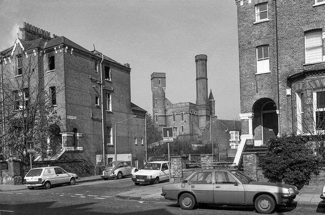
Lordship Park, Stoke Newington, Hackney, 90-4a-01

Taken on Lordship Park and looking up Allerton Road towards the ‘castle’ designed by architect William Chadwell Mylne for the New River Company on Green Lanes, to house steam engines to pump water which had been cleaned in the adjoining reservoirs and filter beds to consumers.

The water was pumped to a large tank at the top of the main structure and then gravity fed to consumers. The towers and turrets disguise the huge industrial engines inside, initially giant single cylinder steam engines linked to pumps. These were later replaced in the 1930s by diesel and electric pumps. The gothic fantasy was felt to be more acceptable in this then select suburb than an industrial-looking building.

When the water board closed down this facility in 1971 it was saved from demolition by Grade II* listing and three years later converted into a climbing centre.

House, Tree, Lordship Park, Stoke Newington, Hackney, 1990, 90-4a-03

A pollarded tree in front of semi-detached houses on Lordship Park. The two story houses have some fine decoration on their doorways and windows. There are larger houses close to Green Lanes.

House, Cars, Green Lanes, Brownswood Park, Hackney, 1990, 90-4a-61

Notices on the house say ‘NO BALL GAMES; and NO PARKING’ but there seems to be some kind of car scrap business running here in front of once fine derelict houses.

House, Cars, Green Lanes, Brownswood Park, Hackney, 1990,, 1990, 90-4a-64

I think these houses were just to the north of Portland Rise on the west side of Green Lanes and have since been demolished and replaced by to modern blocks of flats at 291 and 293 Green Lanes. The building at extreme left is still there.

House, Cars, Green Lanes, Brownswood Park, Hackney, 1990,, 1990, 90-4a-54

Unusually I took 11 frames here and there are six of them on Flickr – but I’ll only post three here.

These houses were a short walk from the West Reservoir where my my next post from this walk will begin.


FlickrFacebookMy London DiaryHull PhotosLea ValleyParis
London’s Industrial HeritageLondon Photos

All photographs on this page are copyright © Peter Marshall.
Contact me to buy prints or licence to reproduce.


A Reservoir, Flats, a Cockerel and a Café

A Reservoir, Flats, a Cockerel and a Café: More from my walk in Highgate on Sunday 19th November. You can read the previous part at Churches, Flats, Houses & a Pineapple – Highgate 1989

New River Company, Reservoir, Engine House, Hornsey Lane, Haringey, 1989 89-11h-43

Beyond these large red-brick buildings that line the north side of Hornsey Lane is the grass covered reservoir built by the New River Company and just beyond that across Tile Kiln Lane is their Engine House dating from around 1859. Now called the Pump House the site includes the base of a large chimney for a steam-driven pump. This reservoir and pump and others in the area became necessary as higher areas in Hampstead and Highgate were developed. The locally listed building has more recently been converted to residential use.

Northwood Hall, Flats, Hornsey Lane, 89-11h-35

A few yards further east I crossed the Archway Bridge, where perhaps surprisingly I didn’t take any pictures of the view down the road. I did take three photographs of one of the ornamental lamposts but haven’t digitised any of these. The two at the east end seem rather similar to some of those on the Thames embankment with entwined fish swimming around them. About 5 years ago the fairly low ornamental fence on each side of the bridge has been augmented with a tall metal fence to prevent people jumping to their death on the road below.

Further east of the bridge is Northwood Hall, an art deco block built as “ultra modern labour-saving” luxury flats in 1935 and designed in a cross shape by George Edward Bright who had earlier worked as an assistant to Herbert Baker, Edwin Lutyens and Guy Dawber. The almost 200 flats were set in extensive gardens with “a restaurant for residents, guest rooms and outdoor amenities including a tennis court. Indoors, there were uniformed porters available 24/7 and an optional maids’ service charged at hourly rates. In kitchens, double door cupboards opening onto the corridors were used to provide additional services including rubbish collection, shoe cleaning and delivery of papers, food and even cooked meals.”

Sat on a hill overlooking London the residents on all but its ground floor have extensive views across London ‘on a clear day as far as Crystal Palace‘ and the building is a landmark visible from much of north London.

Cockerel, Bronze, John Willaas, Ashmount Primary School, Hornsey Lane, Crouch End, Islington, 1989 89-11h-24

This sculpture was commission by and paid for by the architect of the LCC’s Ashmount School, H.T. Cadbury-Brown. Built in 1954-6 it was an important early example of an all-glass curtain wall construction.
The cockerel now stands on top of the wall outside the Whitehall Park School, built on part of the Ashmount site with the rest being used for housing.

Crouch End Hill, Crouch End, Haringey, 1989 89-11h-13

Advertising for Nautilus Fitness and Tree Surgery on Crouch End Hill, immediately south of the former Crouch End Station – where the old track is now the Parkland Walk. I wondered what the large letters BSG on the wall stood for but could come up with no sensible solution. I think the picture is looking down Stroud Green Road.

Crescent Cafe, Crouch End Hill, Crouch End, Haringey, 1989 89-11h-15
Crescent Café, Crouch End Hill, Crouch End, Haringey, 1989 89-11h-15

The Crescent Café was in part of the former Crouch End Station buildings. A Cafe continues here – with a name change to Sercem Cafe for a couple of years before going back to being Crescent Cafe again until around 2021-2 and is now Merro. The station probably dates from when the line opened in 1867; the station closed in 1954 but goods traffic along the line continued until 1970.

The Café was closed on the Sunday I took this picture. At right you can see one of the tall brick pillars on top a a curved wall that go beside and across the bridge across the former railway. I’d photographed the cafe and these twelve years earlier but hadn’t put the wall picture online.

Monkridge, Crouch End Hill, Crouch End, Haringey, 1989 89-11h-16

I turned north up Crouch End Hill and photographed another mansion block, Monkridge, just a few yards further on. This was apparently built between 1912 and 1935 with around 40 flats and a lower building. The two blocks are very similar in design with this being slightly large actually on Crouch End Hill and the other behind on Haslemere Road.

The final post on this walk will follow shortly.


FlickrFacebookMy London DiaryHull PhotosLea ValleyParis
London’s Industrial HeritageLondon Photos

All photographs on this page are copyright © Peter Marshall.
Contact me to buy prints or licence to reproduce.