Reservoir, Castle & Lordship Lane – 1990

Reservoir, Castle & Lordship Lane: My walk on April 1st 1990 began at Finsbury Park Station and the first post, Brownswood Park Finsbury Park – 1990, ended on Green Lanes where this post begins.

Reservoir, Green Lanes, Stoke Newington, Hackney, 1990, 90-4a-45

The New River Path leads from Green Lanes immediately north of the ‘Castle’ and I think I walked from this path to the bank of the West reservoir to make this picture. There have been considerable changes in the area and I can no longer identify the trees or buildings in my view.

The West Reservoir next to the New River dates from 1833, and I think this section of fencing probably dates from when it was enlarged in the 1850s or a little later. The associated filter beds have been built on, but a vigorous local ‘Save the Reservoirs’ campaign in the 1980s saved the reservoirs, with the West used for water sports and the East as a nature reserve.

Reservoir, Green Lanes, Stoke Newington, Hackney, 1990, 90-4a-46

I think this was a part of the filter beds which have now gone. I liked the shadow of the fence and the wheel which presumably operated a valve to control the flow of water, perhaps to the pumping station.

Sand in the filter beds was first used to effectively removed most particles from the water but it was later realised that the slime which grew on top of the sand was very effective in killing bacteria to increase the safety of the water and sand filtration still plays an important role in producing our clean drinking water.

Reservoir, Green Lanes, Stoke Newington, Hackney, 1990, 90-4a-32

I think the man in the picture is a bird-watcher rather than a photographer and is holding up binoculars to his eyes. Many migrating species take a rest at our reservoirs and birders flock to watch them.

The Castle, Waterworks,  Green Lanes, Stoke Newington, Hackney, 1990, 90-4a-21
The Castle, Waterworks, Green Lanes, Stoke Newington, Hackney, 1990, 90-4a-21

The gothic fantasy waterworks, built to house massive steam-powered beam engines in 1854–1856 seen from close by – I needed a very wide lens to include the whole height of the tower. According to Industrial History OnlineThe original six beam engines, two by Watt & Co and 4 by Simpson were removed in 1953.” I think these were then scrapped. You can see similar beam engines in the highly recommended London Museum of Water & Steam in Brentford.

House, Waterworks, Lordship Park, Stoke Newington, Hackney, 1990, 90-4a-24

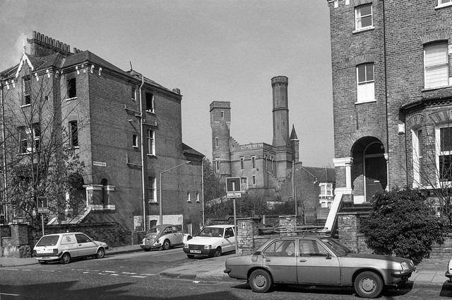
On Green Lanes I walked south and turned down Lordship Park. Here I got a view of the Castle. I think the tower at right is a disguised chimney and the square section on top of that at the left may have held the tank that water was pumped into to give the pressure for supply to customers.

Man Reading, House, Lordship Park, Stoke Newington, Hackney, 1990, 90-4a-13

Another picture in Lordship Park shows the very solid looking houses built there dating from around 1865. These are three storeys with a basement, the steps rising to an elevated ground floor, built in a Victorian Gothic style with the entrances recessed with a side window giving a somewhat clerical look; they have is some nice ornamental brickwork but in a fairly restrained fashion.

There are quite a few of these houses on both sides of thee street and I picked this view because of the man sitting reading the Sunday Mirror on the steps.

Lion, Brothers of Islam, Lordship Park, Stoke Newington, Hackney, 1990, 90-4a-16

A final picture on this street shows the passageway between two houses with a small flowerbed looked over by a lion, and on the post at right in the freely written message ‘Brothers of ISLAM’.

My walk, now in Stoke Newington, continued – more later.


FlickrFacebookMy London DiaryHull PhotosLea ValleyParis
London’s Industrial HeritageLondon Photos

All photographs on this page are copyright © Peter Marshall.
Contact me to buy prints or licence to reproduce.


Brownswood Park Finsbury Park – 1990

Brownswood Park Finsbury Park: My walk on April 1st 1990 began at Finsbury Park Station. I walked a short distance past the gates to the park and then turned right down Queens Drive.

Queen's Drive, Finsbury Park, Hackney, 1990, 90-3m-13
Queen’s Drive, Finsbury Park, Hackney, 1990, 90-3m-13

Queen’s Drive was laid out and developed from 1869, the same year that the park, misleadingly named Finsbury Park despite being a couple of miles from Finsbury, was opened, just a few years after the opening of Seven Sister Road station in 1861. In 1870 the station was renamed Finsbury Park. Most of the street was built up by the 1871 census, largely with substantial and well decorated four-storey terraces.

Queen’s Road – later renamed Queen’s Drive – was built as the ‘best road’ in a new select suburb then known as Brownswood Park, developed at first by John Brookes Porter in 1862. You can read more of its history in the Brownswood Conservation Area Appraisal.

Like many such areas it went downhill over the years. Wartime bombing including a V2 rocket damaged and destroyed a number of houses in it and nearby streets. By the 1950s most of the houses were in multiple occupation by “students, migrants, and the working class.”

This picture is of the rear of the Pembury Hotel which is on the corner of Queen’s Drive and Seven Sisters Road, just a few yards down the road and is a post war addition.

Houses, Princess Crescent,  Finsbury Park, Hackney, 1990, 90-3m-15
Houses, Princess Crescent, Finsbury Park, Hackney, 1990, 90-3m-15

Princess Crescent, also in Browsnwood Park, is not a crescent but two straight lengths of road at an angle joining Queen’s Drive and Gloucester Drive. The houses here were rather smaller than those in Queen’s Road. The other section of road has a two large blocks of council flats, St John’s Court on one side and a primary school on the other. From 1934 until 1960 the Finsbury Park Synagogue was there.

I walked back onto Queen’s Drive and continued to Brownswood Road, turning east and crossing Green Lanes into Lordship Park – not a park but a street.

Lordship Park, Stoke Newington, Hackney, 90-4a-01

Taken on Lordship Park and looking up Allerton Road towards the ‘castle’ designed by architect William Chadwell Mylne for the New River Company on Green Lanes, to house steam engines to pump water which had been cleaned in the adjoining reservoirs and filter beds to consumers.

The water was pumped to a large tank at the top of the main structure and then gravity fed to consumers. The towers and turrets disguise the huge industrial engines inside, initially giant single cylinder steam engines linked to pumps. These were later replaced in the 1930s by diesel and electric pumps. The gothic fantasy was felt to be more acceptable in this then select suburb than an industrial-looking building.

When the water board closed down this facility in 1971 it was saved from demolition by Grade II* listing and three years later converted into a climbing centre.

House, Tree, Lordship Park, Stoke Newington, Hackney, 1990, 90-4a-03

A pollarded tree in front of semi-detached houses on Lordship Park. The two story houses have some fine decoration on their doorways and windows. There are larger houses close to Green Lanes.

House, Cars, Green Lanes, Brownswood Park, Hackney, 1990, 90-4a-61

Notices on the house say ‘NO BALL GAMES; and NO PARKING’ but there seems to be some kind of car scrap business running here in front of once fine derelict houses.

House, Cars, Green Lanes, Brownswood Park, Hackney, 1990,, 1990, 90-4a-64

I think these houses were just to the north of Portland Rise on the west side of Green Lanes and have since been demolished and replaced by to modern blocks of flats at 291 and 293 Green Lanes. The building at extreme left is still there.

House, Cars, Green Lanes, Brownswood Park, Hackney, 1990,, 1990, 90-4a-54

Unusually I took 11 frames here and there are six of them on Flickr – but I’ll only post three here.

These houses were a short walk from the West Reservoir where my my next post from this walk will begin.


FlickrFacebookMy London DiaryHull PhotosLea ValleyParis
London’s Industrial HeritageLondon Photos

All photographs on this page are copyright © Peter Marshall.
Contact me to buy prints or licence to reproduce.


More From Stockwell & South Lambeth

More From Stockwell & South Lambeth: My apologies that the previous post in this series from my walk on 19th July 1989, Tradescant, Old South Lambeth Rd and Caron, ended with a repeat of three images taken on Fentiman Road from my walk two days earlier.

After taking pictures on Old South Lambeth Road I probably simply walked to Vauxhall Station without taking more pictures. But I have now found a few more pictures I took probably at the start of the walk which began with Stockwell Park, Bus Garage, Tower and Mason, and also some at the end of my walk in Vauxhall.

Houses, 43-49, Lansdowne Gardens, Stockwell, Lambeth, 1989  89-7h-14
Houses, 43-49, Lansdowne Gardens, Stockwell, Lambeth, 1989 89-7h-14

These fine houses were built in the mid-nineteenth century and are Grade II listed. The closer and further houses are semi-detached pairs while 47 in the middle is detached. Behind them is the tower block Edrich House on Lansdowne Way.

House, 93, Priory Grove, Stockwell, Lambeth, 1989 89-7i-62

Priory Grove runs south from Lansdowne Way (formerly Priory Road) and much of it is beside Larkhill Park. This four-storey block, with the name at the top Priory Building is close to its end at Larkhall Lane. In 1989 it had two doors, but now there is only one at the left giving access to the four flats inside. The ground floor has been coated with stucco eliminating the architraves which are a feature of the upper floors.

Larkhall Lane, Stockwell, Lambeth, 1989 89-7i-65

Larkhall Lane has a listed building and several on the local list, but all I chose to photograph were a couple of odd corners, the first perhaps showing something of the state of the property with a fine stone hidden pillar. I think this has now disappeared.

Larkhall Lane, Stockwell, Lambeth, 1989 89-7i-52

66 Larkhall Lane is now much improved rendering, a tidy garden and the anachronistic shutter removed. The tree has also gone and I suspect much of the interior has also been remodelled. A property listing on the web describes it now as “This is an attractive 2 bed, 1 bath semi-detached house in Lambeth, London. This efficient home is 753 square feet in size with 2 fireplaces and has been extended 3 times since construction before 1900” and estimates its value at £1m-£1.2m.

341-9, Wandsworth Rd, South Lambeth, Lambeth, 1989 89-7i-56

I think I took this rather rapidly through a gap in the traffic which perhaps accounts for its rather odd tilt. At left is a rather odd Gothic Grade II listed building trying to be a castle, with shops on the ground floor and an octagonal tower at each end. The building dates from the mid-19th century but the shops reaching out to the main road were added probably around 40 years later over what was originally a front garden and have since been much altered.

Tucked away in the centre of the picture is a slim building with some interesting polychromatic brickwork at No 345, small and rather unusual Victorian infill.

Wilbraham House,  Wandsworth Road, Nine Elms, Lambeth, 1989  89-7i-41
Wilbraham House, Wandsworth Road, Nine Elms, Lambeth, 1989 89-7i-41

Through the imposing three story vehicle entrance of Wilbraham House we can see Fosbrooke House behind. This long block of flats occupies most of the block between Thorncroft St and Wilcox Road. One web site helpfully tells me it was built between 1930 and 1949 and my guess would have been it was at the end of that period. Four impressive sets of steps on the frontage lead to the 36 flats, with glass bricks providing natural lighting for the stairs. Nine Elms underground station opened in 2021 is just a few yards up the road.

The Elephant And Castle, pub, South Lambeth Place, Vauxhall, Lambeth, 1989 89-7k-11

You get a good view of these elephants from trains going through Vauxhall Station on the Windsor and Reading lines I normally go to Waterloo on. This picture is taken from immediately outside Vauxhall Station entrance. The pub building is still there but closed in 1997 and is now a Starbucks, but its upper floors look much the same. The local list dates it as mid-late 19th century, but the building replaced an earlier one on the site.

The name Elephant And Castle thought to have been first used for pubs around 1770 in nearby Southwark probably derives from the coat of arms of the Cutler’s Company who adopted it in 1622. They used ivory to make knife handles. Though if so it may have been used first for a pub in the City for which we have no record.

I’ll post the other pictures I’ve found from the end of the walk in Vauxhall later.