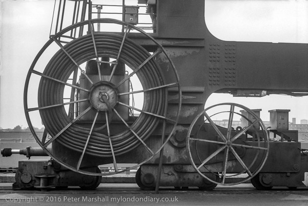
Enderby’s Wharf was where the cables that provided worldwide communication long before the age of radio and the satellites were made. The Telegraph Cable Works was established here in 1854 by Glass Elliott and William Henley, though Henley moved to North Woolwich. The company later merged with Siemens and were taken over by Submarine Telephones and Cables Ltd in 1979, later becoming part of Nortel and then Alcatel. The first transatlantic cables were made here and laid in the mid 1860s by the SS Great Eastern. Manufacture of cables here ceased shortly before I took this picture. There is a short length of cable by the riverside path and this piece of cable loading gear is still by the riverside.
Enderby House was built in 1830 for a member of the Enderby family, who were coopers in London and later moved into shipping and set up a patent rope, twine and canvas factory here, beofre losing their fortunes in the Antartic whaling industry. Grade II listed, it was deliberately allowed to deteriorate. As a condition of planning permission the developer were required to restore it to a decent condition and it is now incorporated into a larger building, though not I think as it originally was.
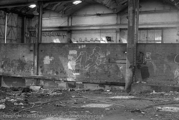
Disused Wharf, North Greenwich, Greenwich. 1980 24j-34: wharf, derelict, graffiti,
Another picture inside the derelict shed at Bay Wharf. Among the scrawlings on the wall was a rather better than averagely drawn chalked reclining nude, apparently signed by the artist, ‘John 25.5.80’, almost certainly the day before I took this picture on the Spring Bank Holiday, which that year was on May 26th. The view also shows some details of the building and its vaulted roof.
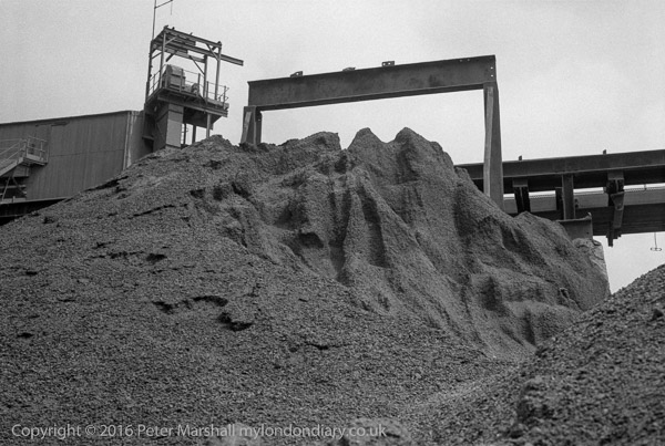
Sand and gravel wharf, North Greenwich, Greenwich. 1980 24j-41: wharf, sand, gravel,
Sand and Gravel at Granite Wharf. The site is now occupied by new and expensive flats. The whole area, including Greenwich Wharf, Lovells Wharf, Granite Wharf, Providence Wharf, Badcock’s Wharf, Pipers wharf and Cadet (or Paddock) Place is now known as Greenwich Wharf.
Sand and gravel wharf, North Greenwich, Greenwich. 1980 24j-42: wharf, sand, gravel,
More sand, aggregate and gravel at Granite Wharf, which remained in use by Tarmac until mid-2001. It was first let by Morden College to Victorian road builder John Mowlem in the 1840s.
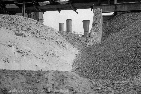
Riverside path, River Thames & Sand and gravel wharf, North Greenwich, Greenwich. 1980 24j-43: wharf, sand, gravel, footpath, river
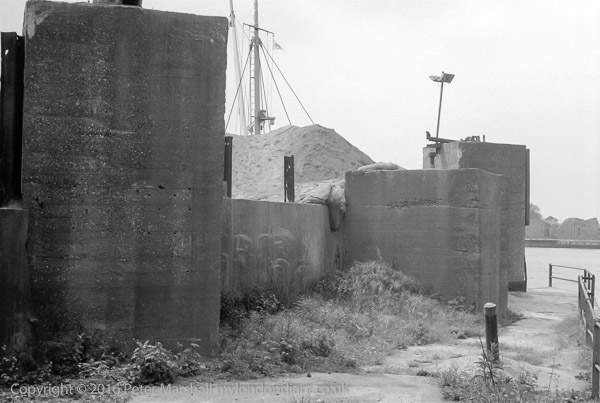
I think the massive concrete blocks were bases for cranes at the wharf. The inlet here where Cadet Place left the riverside path was known locally as Dead Dog Bay, Mary Mills suggests possibly because animals which escaped the Foreign Cattle Market at Deptford and were drowned washed up here.
THe whole area is no covered by recently built flats, The River Gardens, where a 2-bed flat will cost you a little over £600,000, and Cadet Place no longer exists. A walkway, River Gardens Walk, with steps up from Banning St opposite Derwent St occupies roughly the same position.
Pier, River Thames and view of Millwall, North Greenwich, Greenwich. 1980 24j-44: children, pier, river,
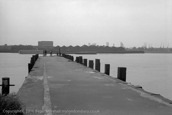
One of several piers on the riverside path, this may be at Primrose Wharf, but if so had been considerably modified since I took this picture. I don’t think the pier was officially open to the public at the time I made this picture.
Primrose Pier belonged to Amylum and was later opened by them to the public but in 1998 it was resurfaced and part-rebuilt by the Groundwork team, with reed beds being added on either side and disabled access provided.
In typically perverse fashion I’ve decided to put an increasing amount of my work on Flickr just as it seems the platform is possibly going downhill fast, with a begging letter from the CEO which also includes a 25% off offer for the ‘Pro’ subscription to those with free Flikr accounts .
I’ve had a free Flickr account for a long time, simply because I needed one to subscribe to another, now defunct organisation. I put a fairly small number of pictures on it, I think around 75, and then forgot about it.
What made me think about it again was simply the fact that my web space is filling up and near its limit, not in terms of space but for the number of files. There is a limit on my account of 262,144 files and I’m currently at the 225,419 mark.
262,144 seems to be quite an important number in computing, which I’m sure is connected to the fact that in binary it is 1000000000000000000 (in hex 40000) and has some connection to the way in which the accounts are set up in Linux. It seems a pretty huge number, but I find that my web space currently contains just short of 200,000 image files. In November 2019 on My London Diary I added another 837 images, along with another 31 html files, and over the whole year over 14,000 files, while other web sites and this blog added at least another thousand or two. So things are getting rather close to the limit. Either I’m going to have to delete some or get another web account of some sort.
I don’t actually generate much income directly from the web, but make everything available free online and without advertising. I do occasionally sell prints or get repro fees because people have seen work on the web, but it hardly pays my costs (and certainly doesn’t repay the hours of work I put in.) I do it more because I want to share my photography and my thoughts with other people.
Importantly for me, there is a lot more work that I would like to share. Fifteen or twenty years of work in both black and white and colour, particularly on London, that has hardly been seen except by myself and a few friends and colleagues, with just perhaps just a few hundred of the probably more than a hundred thousand of the images having been published or exhibited. It includes several major projects along with much other work.
I had hoped earlier this year that a major institution would take ‘My London Diary‘ under its wing, enabling me to free almost 200,000 files from my personal account, but after some discussion and lengthy deliberation they decided that they just did not have the resources to do so. I’m open to offers from any other body that would like to host this unique record of around 20 years of London’s history covering protests and other events on the streets – and for that matter my earlier film-based work.
I decided to do a little research on ways that would be effective both in terms of cost and time in sharing my work on-line and thought seriously about two platforms, Instagram and Flickr. Neither seemed particularly suitable and both have interfaces that really don’t work well for what I want to do. I tried out putting a little work on each of them and in the end decided that for all its peculiarities (and it has a seriously dated and inconsistent interface) Flickr seemed the better for my purposes. So I’ve now signed up for a ‘Pro’ account that will enable me to put as many images as I like on line.
At the moment there are three new albums of my old pictures on Flickr: 1977 London Pictures
There are also a few pictures from the 2000’s, including albums on Paris and on Croydon’s Trams which I added in 2007 when I first set up my Flikr Account. Then I made the mistake of only putting on the files at a small size and low quality, using the images from my web site, while I am now uploading 2400 pixel wide repro quality files which display the work much better. Of course these may now be used by the unscrupulous who are prepared to ignore the copyright notice, but I hope that there are enough honest people around who will contact me and pay to make the risk worthwhile.
All of those London pictures in the albums above are also available on my web site, but you can now see them rather larger and better on Flikr along with the comments that I wrote when putting most of them on Facebook a day at a time.I’ll also probably at some time put the images that are on my Hull web site onto Flickr in hight quality, and then remove both the Hull and London sites from the web, leaving just a residual site which links to the Flikr albums. Together with removing a few other old sites this might give me space for another year or so of My London Diary.
All photographs on this and my other sites, unless otherwise stated, are taken by and copyright of Peter Marshall, and are available for reproduction or can be bought as prints.
There are no adverts on this site and it receives no sponsorship, and I like to keep it that way. But it does take a considerable amount of my time and thought, and if you enjoy reading it, please share on social media. And small donations via Paypal – perhaps the cost of a beer – would be appreciated.
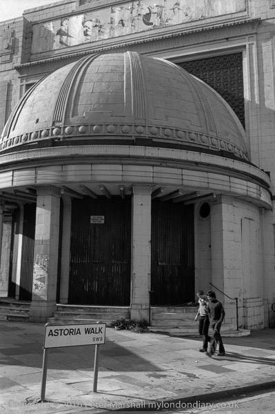
Brixton Astoria looks in fairly poor shape in this picture, with a notice warning there is a 24 hour dog patrol.
The building opened as a cinema and theatre in 1929, closing in 1972, becoming briefly a rock venue but closing in months. The Rank organisation wanted to demolish it to replace it with a garage and car showroom, but it is Grade II listed. They were using it as a store when I took this picture.
It reopened as a rock venue in 1981, but went bust, was bought for £1 and re-opened it as the Brixton Academy in 1983, becoming a success. Refurbishment in 1995 restored much of its original Art Deco features.
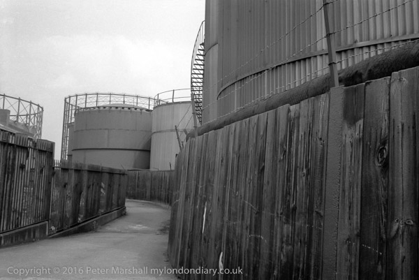
Footpath, Oil storage tanks and gas holders, North Greenwich, Greenwich. 1980 24h-31: footpath, fence, storage tank, gas holder
The riverside footpath leads away from the river here, winding slightly around the oil storage tanks on its way to a bridge across the Blackwall tunnel approach. The northern area of the Greenwich Peninsula was at the time occupied by the Greenwich power station and gas works, as well as several wharves, including the Victoria Deep Water Terminal, where the footpath was marked out by yellow lines under the travelling cranes. You could walk through there by the river before the path led you between buildings to Tunnel Avenue, close to the brick tunnel entrance, always polluted and dusty. There was then no riverside path around the north of the peninsula, and the path only rejoined the river on Bugsby’s Reach having gone past The Pilot on River Way (a few yards south from where Pilot Walk now is.)
Only one of Greenwich’s gasholders remains, and that is currently threatened with demolition. Most of the storage tanks have now also gone. The riverside footpath which has been closed for some time while riverside flats were being built and work carried out on the river wall is now open, and you can now walk all the way from Drawdock Rd near North Greenwich station into Greenwich, as I did with friends a couple of weeks ago. Although the walk lacks much of the interest it had back in 1980, it still makes a pleasant walk – and you might see a seal, though we only saw some good pictures of one taken earlier by one of the building workers.
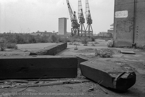
Disused Wharf, North Greenwich, Greenwich. 1980 24h-33: dock, cranes,
The tower block across the river is Kelson House on the Samuda Estate, 25 stories and 87m high and completed in 1967 with 144 flats for the LCC/GLC. Tower Hamlets Council privatised the estate in 2005 to a resident-led housing association which was taken over by One Housing Group in 2007. The estate takes its name from the shipbuilding company which was on the site from 1852 to the 1890s. Owned by Joseph d’Aguilar Samuda, it was the largest London shipbuilder in the 1860s. Later the site was used by various other industries until badly damaged by bombing in 1941. It was then used for storage until purchased by the LCC to build the estate.
I find it hard to identify now exactly where this picture was made on the riverside path, but I think it must have been on Bay Wharf and the cranes right of centre were those on the corner of the Victoria Deep Water Terminal.
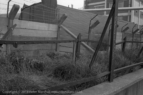
Riverside path, North Greenwich, Greenwich. 1980 24h-43: works, path, fence,
It was hard to see why there should be three separate fences (or the remains of them) with a narrow stretch of grass and weeds between them at the side of the riverside path. The most serious was at the back, with heavy concrete lengths between the concrete posts, with angled tops to support half a dozen runs of barbed wire. Clearly the lower rusted iron fence posts in front of this once supported something else from the bolts every few inches along the length of the horizontal members, while the foreground structure along the top of the wall must once have supported some chain-link fencing.
The picture was I think taken somewhere along by Morden Wharf or Enderby’s Wharf, but I can’t place it more precisely, though others may recognise the building in the background. Like almost everything else along this stretch of the river it will have been demolished and either already has been or soon will be replaced by expensive flats.
Lovell’s Wharf, Riverside Path, North Greenwich. 1980 24h-52: footpath, wharf,
Though I deliberately cut it down to ‘LOVE’ the writing on this wall was rather longer, reading I think ‘C. SHAW LOVELL’S LTD WHARF, with a second ‘LOVELL’S WHARF’ a few yards upstream. The signs were repainted a few years after I took this picture.
I’ve written earlier about this wharf, so here it is again (with minor corrections):
“The wharf remained in business until the early 1980s, when the increasing size of ships required a deeper berth. Until the 1840s this area of land was ‘The Great Meadow’ and belonged to Morden College. In 1838 they leased the land to William Coles Child who then ran his family’s coal trade business from Belvedere Wharf where the Royal Festival Hall now stands. They brought in coal to Greenwich from the north-east – Newcastle, Blyth, South Shields, Seaham – to the new ‘Greenwich Wharf’ and leased more land from Morden College, setting up coke ovens and a limekiln.
Coles also developed the streets close to the wharf, naming them after colleries in Durham. Pelton Rd got its name from Pelton Main and West Pelton collieries at Chester-le-Street in County Durham.
Greenwich Wharf became run by other companies, changing its name and in the 1920s the lease was bought by Shaw Lovell (now Bristol ICO Ltd) a family business from Bristol dating from 1869 who had been using the wharf since before the First World War. The renamed it Lovell’s Wharf, painting the name in giant letters on the wall beside the riverside path.
The two cranes are actually Scotch derricks. They were removed by Morden College in 2000, one of a number of of controversial aspects over the development of the site into “a contemporary riverside development” by bptw architecture for London and Regional Properties.”
The whole area was renamed by the developers as Greenwich Wharf and the riverside path, once open again, is much wider, but far less enticing.
Mary Mills has written in detail about Lovell’s wharf (and many other aspects of Greenwich’s Industrial History), and most of the information here comes from her Greenwich Industrial History blog.
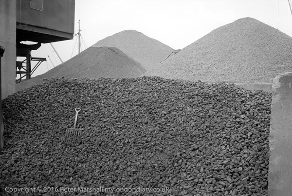
Gravel wharf, North Greenwich, Greenwich. 1980 24h-54: wharf, gravel, fork
Gravel Wharf was on the riverside just to the north of Lovell’s Wharf, with Piper’s Wharf just to the north of it, extending out over the riverside path. An alley, Cadet Place ran between Lovell’s and Granite Wharf, roughly where River Gardens Walk now is.
Looking at the mast and rigging behind the gravel heaps at left of picture, I think this must have been taken from Cadet Place.
I looked at that small hand form on the huge pile of stones and thought of the Augean stables; this must surely be one of the Labours of Hercules, though I doubt if even he would have cleared the pile in a day.
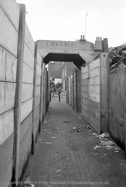
‘WARNING – OVERHEAD CRANE’ says the notice, and although the roof over the path was there to protect you from large chunks of scrap metal falling from the crane it was always wise to wait if it was operating overhead.
Through the arch, the path leads on to the houses still there on Ballast Quay and beyond them the side wall of the Cutty Sark pub (renamed when the Cutty Sark was brought to Greenwich, but a genuinely old pub, formerly called the Union Tavern’. It isn’t a bad place but gets rather crowded with tourists, and if you want to drink beer it is probably worth the short walk down Pelton St to the Pelton Arms, which also at times has live music (which may not be to your taste.)
The former scrap metal yard at Anchor Iron Wharf, Robinson’s Scrap Metal, was developed as luxury flats in 2003, with an area in front which Berkley Homes and Royal Borough of Greenwich agreed would be deemed public land and includes a seating wall and a few trees. However planning applications were made last year which would take part of this back as outdoor restaurant seating.
To be continued…
All photographs on this and my other sites, unless otherwise stated, are taken by and copyright of Peter Marshall, and are available for reproduction or can be bought as prints.
There are no adverts on this site and it receives no sponsorship, and I like to keep it that way. But it does take a considerable amount of my time and thought, and if you enjoy reading it, please share on social media. And small donations via Paypal – perhaps the cost of a beer – would be appreciated.
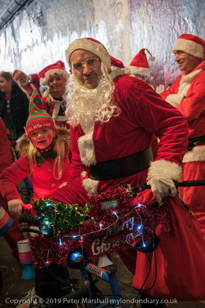
BMX riders gathered in Leake At under Waterloo Station in the graffiti-covered tunnel to wait for the start of Santa Cruise 6, a charity ride by santas on BMX bikes raising money for a Children’s Heart Hospital by BMX Life, now in its sixth year.
With best wishes for Christmas and the coming year.
Taken, again on the Minox, on a family outing to Brixton to an Open Day at the windmill which was then being restored. I didn’t take any black and white pictures of the windmill, but I think I may have taken a camera with colour film and made some family pictures with that, though I can’t at the moment find them.
We’d walked around Brixton in a slightly indirect way to get to the windmill, and on the way home I suggested another diversion, coming out from Blenheim Gardens and going across Brixton Hill to one of the roads opposite, perhaps Josephine Avenue.
A few years later I tried to go back and find this basement, but could not locate any properties in the area with similar short steps from the pavement up to the front door and down to a basement below. It may still be there somewhere, perhaps a little further away than I remember, or it may have been demolished.
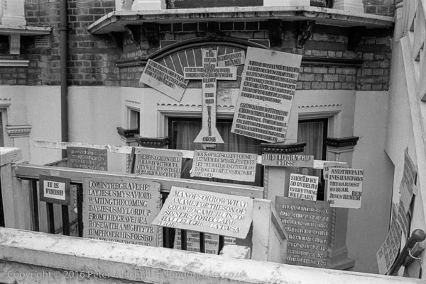
I’d hoped to find it again, and perhaps to have stepped over the wall and gone down the steps to the door at the right and rung on the bell and found out more about the person who painstakingly created all of these signs with their curious mis-spelling such as ‘THE OLD WRAGGID CROSS’
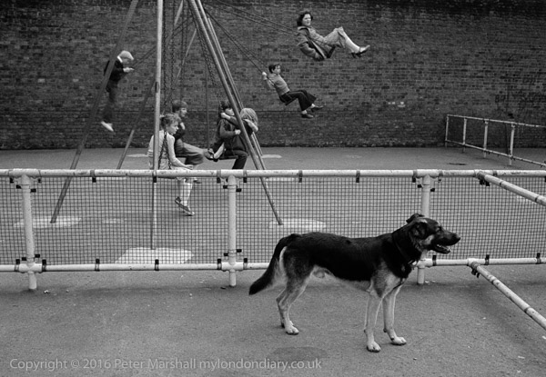
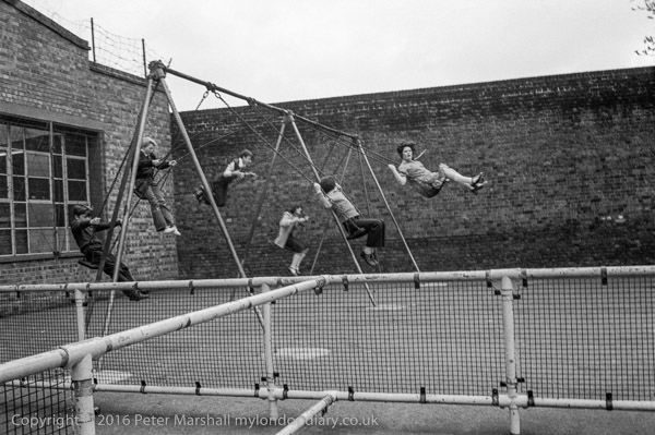
I think this playground was close to Brixton Windmill in Blenheim Gardens. I had come with my family to visit the Windmill. My two young boys were too young to go on these swings even had they not been in used, and the dog didn’t seem too friendly.
It is a typical old-fashioned playground made when kids were made of tougher stuff and minor injuries from falling on tarmac and concrete were taken for granted.
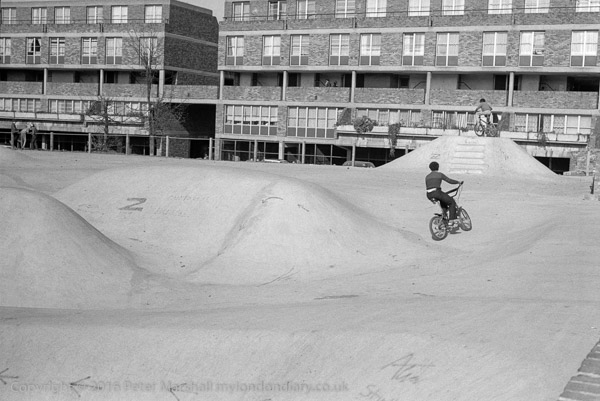
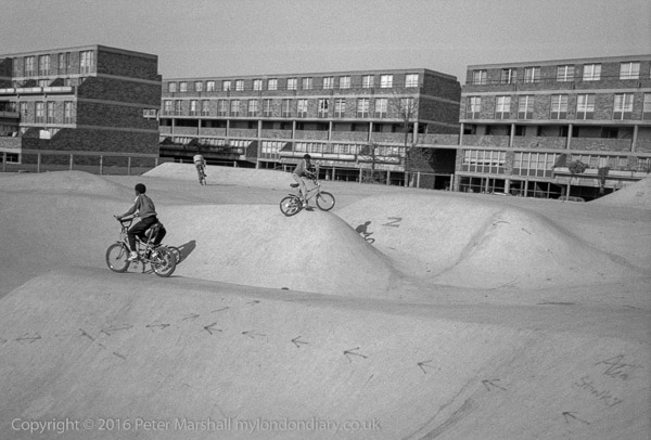
Stockwell Concrete Bowl Skatepark is still there at the corner of Stockwell Rd and Stockwell Park Walk, along with the flats behind on Benedict Rd, Barrett House, part of the Stockwell Park Estate, which was completed in 1976.
The estate got a bad reputation, particularly following the 1981 Brixton riots, though it was one which, despite some crimes which got wide coverage in the scandal sheets, it never really deserved.
These flats were pretty new when I took this and several other pictures, as was the skatepark. The skatepark is now an “Asset of Community Value”, and street art from it was featured on the reverse of a Brixton Pound note commemorating Lenford (Len) Kwesi Garrison (1943 – 2003), co-founder of the Black Cultural Archives. The flats were refurbished in 2014 and considerable attempts have been made to improve the estate, including a very expensive CCTV system and much gardening.
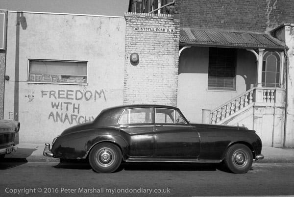
Freedom With Anarchy, Aristotle Rd, Clapham, Lambeth. 1980 24g-14:
Who could resist going to photograph Aristotle Road – and finding there this graffiti ‘Freedom With Anarchy’?
“Anarchism has but one infallible, unchangeable motto, “Freedom. Freedom to discover any truth, freedom to develop, to live naturally and fully” according to US anarchist, writer, labour organiser and IWW founder Lucy E Parsons (1853-1942), a remarkable woman who was probably born a slave, though she claimed only Native American and Mexican descent. Chicago police described her as “more dangerous than a thousand rioters…”
Books have been written about Aristotle’s concept of freedom, and according to the Oxford Handbook of Freedom he thought that “a person is free to the extent that he is able to live a life of politics and philosophy, and a polis is free to the extent that its institutions promote such a life for each and every citizen by removing the impediments to its realization“.
You can still recognise the location, just off Clapham High St, at the rear of Pearl Pharmacy though the balustrade, roof and stained glass have gone, the road name with its old S.W. is still on the wall. The car parked there back in 1980 was a little unusual, and is I think a T-Series Bentley. I thought at the time it looked a suitable motor for gangsters.
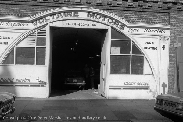
Not far from Aristotle Rd is Voltaire Rd, which runs from Clapham High St alongside the railway line and includes Clapham High Street station. Railway arches used to be cheap business properties including many garages such as Voltaire Motors but times are changing. These arches were refurbished around ten years ago and seem now to be largely Artisan Coffee Bars, bars and eateries. I think the arch which used to house this garage became The Bridge Cafe.
Voltaire Motors actually looked considerably better than any of the small row of businesses that now occupy these arches; although the interiors may have been improved by refurbishment the outside has certainly deteriorated since 1980.
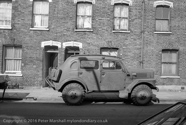
From the fairly distinctive decorations above the upper floor windows and doors I think this picture was taken in Lendal Terrace, off Clapham High St, alongside the railway on the other side of road and railway from Voltaire Road.
Experts in military vehicles will probably recognise the vehicle parked here, with a high wheelbase for going off-road. It looks American to me, and vaguely like a Humvee, but I’m almost certainly wrong.
All photographs on this and my other sites, unless otherwise stated, are taken by and copyright of Peter Marshall, and are available for reproduction or can be bought as prints.
There are no adverts on this site and it receives no sponsorship, and I like to keep it that way. But it does take a considerable amount of my time and thought, and if you enjoy reading it, please share on social media. And small donations via Paypal – perhaps the cost of a beer – would be appreciated.
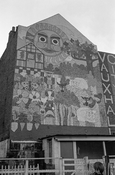
The mural announcing the presence of Vauxhall City Farm has I think long gone, and there has been considerable development of the buildings there. It now seems to me obviously to be a picture I should have taken in colour, and possibly I did, though quite likely I had only a single camera with me loaded with black and white film.
This picture was taken on a Minox EL, a tiny 35mm camera hardly large enough to take the film cassette, with plastic case whose front folded down pulling out the lens into position. Said to be the smallest 35mm camera in the world, it had a 35mm f2.8 lens, weighed only 200g and fitted into even a shirt pocket. For over 20 years one of these cameras (I got through 3 or four) went with me more or less everywhere.
They weren’t cheap (they were distributed by Leica in the UK) and were tricky to use, and the auto-exposure was often unreliable – later I found it worked better if you held the camera upside-down. The first one I bought just couldn’t take sharp pictures, and I sent it back to Leica, who wrote a rather snooty letter saying there were no performance specifications for the lens, but did exchange it for one that was tack-sharp. A few years later, that stopped working after it jumped out of my pocket when I was cycling to work and I got it replaced on insurance (and a hefty jump in premiums the following year.) When I had to send that one back to Leitz they said it was beyond economic repair but sold me a replacement at cost.
The Russians liked the Minox 35mm cameras so much they produced their own exact copy, the Kiev 35A, and I expect their spies still carry one on their visits to English cathedrals.
Rather more buildings along the riverside are now visible across Vauxhall Pleasure Gardens from Tyers St than when I took this picture, but the backs of the houses on Kennington Lane are still recognisable, and the shops along their front have changed only a little to reflect the increasing gentrification of the area – at had at least last time I walked along there from the station to take a camera in to Fixation. The buildings on the green have also been replaced by a newer block along Glyn St.
The area in the distance, where only two blocks of buildings appear has become one of the fastest growing areas in London. I think the block right of centre might be the Nine Elms Cold Store, closed in 1979 but not demolished until the late 1990s, but cannot identify the block at left. There are now high rise buildings covering almost the whole of Nine Elms with more still being built. Along with expensive flats for foreign investors there is also expensive student housing built to lower standards but equally tall.
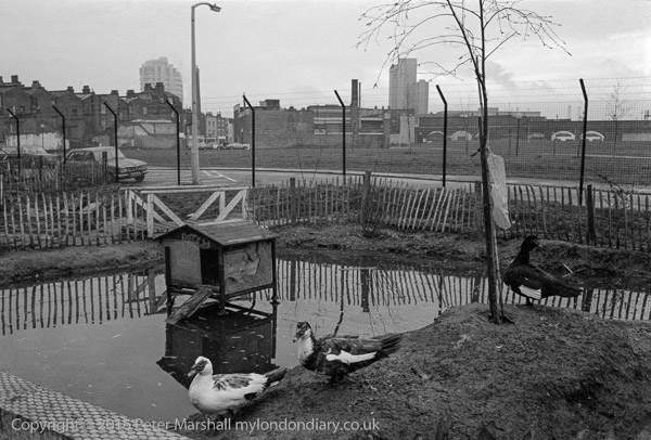
I think the duck pond with its duck house (presumably less ornate than MPs can afford on their expenses) has also gone, with new building on the City Farm site and an expansion of the farm estate.
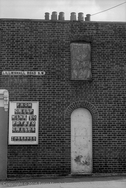
The house here was clearly a corner shop in use as an off-licence and it can still be seen on the corner with North St, though now simply housing. The adverts, including that covering the window at right, are long gone.
It was that faded upper sign advertising ‘RADIO REPAIRS’, and under it what I think must have once been the word ‘EXPERTS’ above the blanked out doorway that attracted me to take the picture of what was otherwise a very ordinary Victorian working-class building, typical of the area.
I’m surprised I didn’t take a picture of the whole side of the building, which actually has three such doors in a row, only the central one in use, each with a window above. But probably only the window in my picture was covered by advertising, and I suspect that the lens on my Leica simply did not have a wide enough view to show all three.
I also failed to photograph the now listed former “Tim Bobbin” pub, just down Lillieshall road, named after the Lancastrian schoolmaster, caricaturist and dialect poet who called himself the Lancashire Hogarth, and was a schoolmaster and notorious drinker born in Urmston who lived and died in Milnrow on the edges of Rochdale, where he is buried in St Chad’s Churchyard, his gravestone carrying the epitaph “Jack of all trades…left to lie i’th dark” he wrote for himself minutes before his death.
I don’t know why he should be celebrated by a pub in Clapham (there is one in Burnley too) nor why the owners should have decided around ten years ago to change the name to ‘The Bobbin’ and replace his rather pleasant portrait on the pub sign to a rather less interesting silhouette.
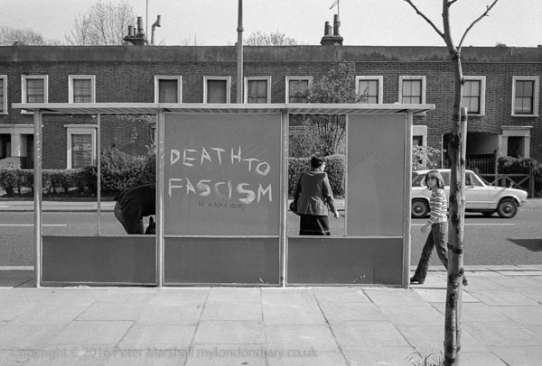
Death to Fascism, Bus Shelter, Battersea, Wandsworth. 1980 23t-32: house, graffiti,
I can’t at this remove remember why I was wandering around South London taking pictures with the Minox on a day in April 1980, but I’m fairly sure I had not gone out with the main intention of taking pictures, otherwise I would have picked up the Leica or possibly my Olympus OM-1.
There must have been some other reason for my being there, and obviously having some time to spare. One possibility is that I had gone early and decided to walk from Queen’s Road Battersea to a meeting or exhibition at the Photo Co-op in Webbs Road in Clapham, which had started the previous year, rather than take the shorter walk from Clapham Junction.
As usual at the time I have no record of exactly where I was, and this street is fairly typical of many of the wider streets in the area, with its late Victorian housing. Only the main roads are this wide and have a pavement where I could get back far enough to make a picture like this with the 35mm lens.
I suspect I will have waited some time, not for the bus, but for people at the bus stop to arrange themselves rather better in the frames provided, but with little luck, and I think made this exposure as the bus the bus was about to arrive, knowing they would board.
Obviously it was the graffiti that attracted my attention. The large white letters of ‘DEATH TO FASCISM’ are easy to read in this small image but the smaller black ‘Kill A BLACK TODAY’ is perhaps harder to read.
This is a section of a terrace somewhere in the Park Town estate in Battersea, around Queenstown Road, built up from the 1860s by James Knowles junior, one of London’s early organised and managed estates. Though well conceived it was not a great financial success, as the middle-classes for whom it was intended rather looked down on the pollution from the adjoining railways to north and east, and the estate was then re-purposed towards more working class artisan tenants.
Probably this property – a ‘six-roomed’ house – with external decoration to make it look rather grander than it was – was built as the three flats the doorbells now indicate, one on each floor. Much has been written about the estate, which led down to the rather grander buildings of Cedars Road and the North Side of Clapham Common.
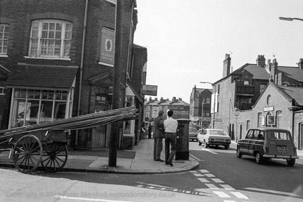
Broughton St, Battersea, Wandsworth. 1980 23t-53: house, pub, church, hall
This corner of Broughton St and St Philip St, looking towards Queenstown Road is still recognisable, though the Market House pub is now a private house and the RIdley Hall at the right of the picture has been rebuilt as Ridley Hall Evangelical Church, though in a similar design.
I took two frames with the Minox, with a fairly similar composition, but while the other was a little more upright, this is sharper. They were obviously taken within a few seconds, though the film wind on the camera was rather difficult to do at any speed, as neither the two men on the street corner or the group further down the street appear to have moved, but the cars are a few yards further down the road in the other image.
The ladders on the handcart reminded me of my father who often used a similar conveyance to take his ladders, paint, tools and occasionally beehives around Hounslow (and sometimes further afield) until his retirement in the late 1960s. By 1979 this was becoming rather less common, though one still saw window cleaners and others who had not yet acquired vans.
It may not have escaped your notice that we are approaching Christmas and the New Year. This is a time when I may not be at a keyboard every day and will be concentrating on other things than writing posts for this site. But also when those of you who read it (and about 4,500 pages are currently read each day) will perhaps want something to entertain you when suffering from an excess of Turkey and mince pies.
Those of you who follow me on Facebook will know that for some time I have been posting an image and its story from my black and white work in the 1970s and 80s each day. But FB is pretty ephemeral, although it keeps a record of everything we post, comment or like to aid its profit-making activites, anything we posted more than a few minutes ago soon becomes hard to find. So as I’ve done previously I’ll post a series of digests here on >Re:PHOTO, where it is always easy to search the archives, and search engines should be able to find content. So here we go with the first set from 1980.
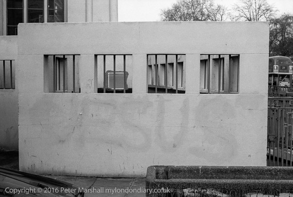
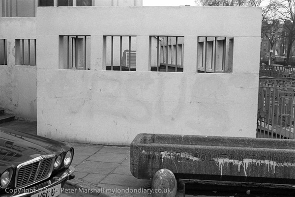
I didn’t see this graffiti until it was faint, though its message was still clear, on the southern corner of Mornington Crescent. The wall is still there, though I can see no trace of ‘JESUS’, and the wall is now kept in better condition, doubtless having been painted several times since – and there is now a gate at its left.
The game ‘Mornington Crescent’ had made its first appearance on ‘I’m Sorry I Haven’t a Clue’ in August 1978, around 18 months before I made this picture, and it was doubtless in my mind on my wandering walk from Central London via St Pancras in February 1980 which took me to the street from which the Underground station and the great game were named.
The wall is at the end of the ‘Black Cat factory’, the former Arcadia Works of the Carreras Cigarette Factory, one of the finest remaining Art Deco buldings in London, controversially built between 1926-8 on the communal garden of Mornington Crescent. Designed by M.E and O.H Collins and A.G Porri, the long building (168m) was where Craven ‘A’ cigarettes were made, and the logo of the company, a rather domestic looking black cat, was reflected in two large Egyptian cats on each side of its entrance. High along the frontage, above the Egyptian-style pillars were a row of the trademark-style black whiskered moggies. But back when I made this picture, the factory was in a poor state, the decorations stripped when it had been converted to offices in 1961. The two giant Egyptian cats, representations of the Egyptian cat god Bast had been shipped out when the factory closed in 1959 to stand in front of other Carreras factories in Basildon and Spanish Town Jamaica. Apparently Carreras had originally planned to call the factory after Bast (aka Bastet) but then realised that everyone would refer to it as Bastard House.
Years later I got a shock when sitting on a bus going up the Hampstead Road, and had to rub my eyes and pinch myself to be sure I was not dreaming as I passed the factory restored to its former glory (almost) and with two black cats again guarding its entrance. The factory had been bought by a new company in 1996 who had restored it to an excellent replica of its Art Deco original. And had doubtless painted out any remaining traces of ‘JESUS’.
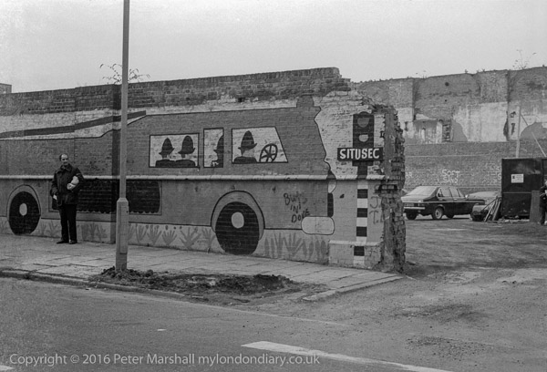
Fire Engine, Mornington Crescent area, Camden, 1980 23i-21: graffiti,
Situsec seems to be a company which supplied asphalt and similar materials and made road repairs, but I can’t remember exactly where this picture of one of their yards was taken, though earlier in my walk I had been on Phoenix Road in Somers Town and a couple of frames later I was photographing painting on a fence on a corner site on Mornington Place for the Albert St Carnival. This yard was somewhere in my wandering between the two.
The walls are tall and thick, with buttresses; that in the foreground appears to have been built up with a thinner extension, which can also be seen on the rear wall, above which another brick structure, with arches roughly doubles the height to something like 20 ft, suggesting a building on a truly giant scale, which in this area suggests it was a part of some major work connected with the railways, either around St Pancras or Euston.
Clearly the wall on which the fire engine was painted has been fairly crudely breached since it was painted to provide or widen the entrance to the yard, where some cars are parked and notices on the wall read ‘Soft Sand’ and (I think ‘Sharp Sand’, though only a couple of letters of this are visible.)
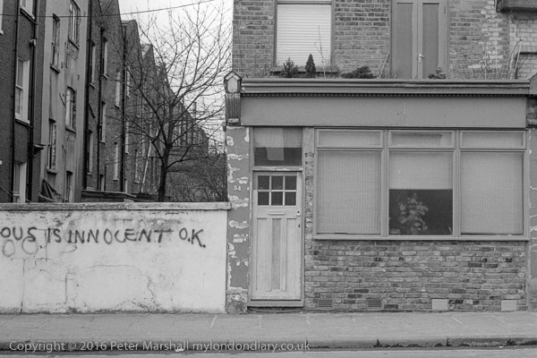
In 1974 the message ‘G Davis is Innocent, OK’ began to appear on walls, bridges and elsewhere across the country, protesting the innocence of the east London minicab driver jailed for his part in an armed robbery. Police were caught out as having lied to get his conviction, making up a statement he was alleged to have made, fiddling the results of ID parades, deliberately ignoring evidence. His conviction was clearly unsafe, and almost certainly he was innocent of that particular robbery at the London Electricity Board’s offices in Ilford for which the police had fitted him up – and for which he was the only man convicted.
Of course, though innocent of this particular crime, Davis was a villain, and within a couple of years of his release in 1976 by Royal prerogative he was back in jail again, this time admitting his guilt, for an armed robbery at the Bank of Cyprus on the Holloway Rd.
The graffiti in this picture was clearly inspired by this case, though who was innocent I clearly intended to remain anonymous, with only the final ‘OUS’ of the name in frame, next to the former shop at no. 54. Which street this was on is also something of a mystery, and I think the house in question has probably been so altered as to be unrecognisable.
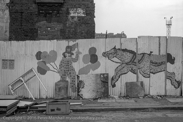
Mornington Buildings were on Mornington Place, I think at its corner with Mornington Terrace, and were in process of demolition when I photographed this painted fence. At its left are two posters for the ‘Albert St Carnival’, too small for the details to be clearly read, but which had I think been on the 14th July, probably from the previous year, 1979, and for which I assumed the painting had taken place.
The 2nd Earl of Mornington was the elder brother of the Duke of Wellington and became Governor-General of India, defeating the French there and making it a part of the British Empire. During the Napoleonic wars, by now Marquess Wellesley, he became ambassdor to Spain. By the time this estate was being developed in the 1820s he was made Lord Lieutenant of Ireland.
FB comment by Ken Bates: There was 2 separate blocks for Mornington Buildings, the larger block was on Mornington Terrace (now Clarkson Row), this block went right up to the corner with Mornington Place. There was then a gateway into the grass area behind it before the smaller block that was in Mornington Place.
It should be easy to locate an image which contains a street sign and a street number, but although the street sign says Phoenix Road NW1, this is misleading, and this picture was made at the corner of what is now Brill Place and Midland Rd. The 1894 OS map actually calls the road Phoenix St, and shows a railway line crossing it – which I think the arch at extreme left was supporting – leading to the goods yard now the site of the British Library and Francis Crick Institute.
The Brill was the area between Euston Square and Kings Cross Station, getting its name from a tavern there and had a Sunday market where the many navvies in the area would come to buy their boots and clothing. Why the pub was called ‘The Brill’ seems a mystery; perhaps it was from the fish of the same name, or some connection with the Buckinghamshire village (there is a Brill in Cornwall too as well as Den Briel in the Netherlands, and it is also a Dutch family name) or was the word ‘brilliant’ just too long to fit on the inn sign?
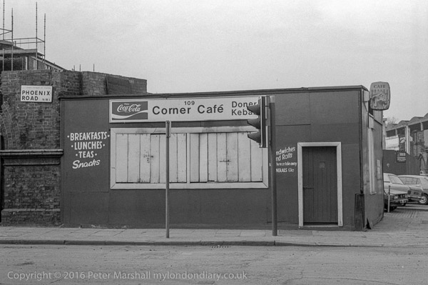
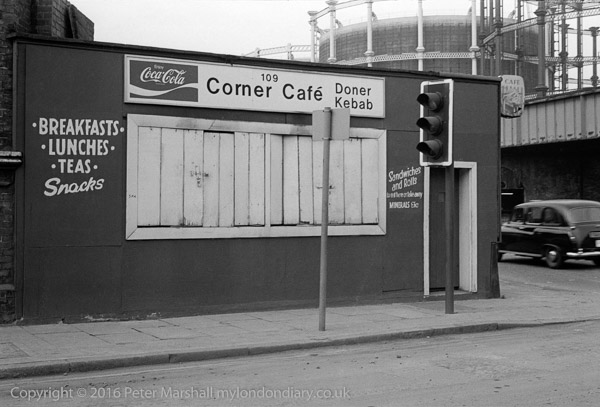
Corner Cafe, Phoenix Rd/Midland Rd and gas holders, Camden, 1980 23i-33: cafe, gas holders, traffic light,
A second picture of the Corner Cafe makes its position clear, showing both the gas holders on the corner of Wharf Rd and Cambridge St (now Camley St) and the road under the railway lines from Midland Rd that led to them, though the scene has now changed completely with the rebuilding of St Pancras Station to provide a shopping precinct which makes the walk from the Underground platform to get on a train much longer, something I curse every time I use the station.
The site of the cafe is now a rather neglected piece of land at the edge of the parking area for Neville Close. The gasholders are no longer on their original site and have flats inside them and St Pancras station now extend much further to the north.
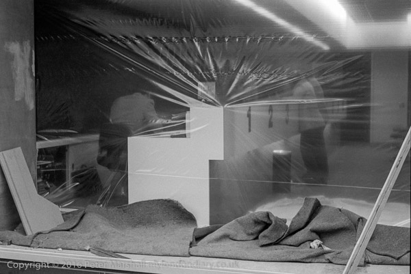
Much of what people think of as central London is a part of the London borough of Camden and I think this shop being fitted out was somewhere in the area roughly between Trafalgar Square and Monmouth St, and the next frame on the contact sheet (not shown on this site) is in Monmouth St, with the name board for ‘Neon’ and the ‘ghost sign’ next door for B Flegg, saddlers. This picture could well also have been in Monmouth St.
I walked around this are fairly often when visiting the Photographers’ Gallery, then on Great Newport St. In 1980 it acquired a second space a couple of doors down from the original premises. As well as showing some great photography (and particularly in later years some rather less great) it also had a cafe where you could sit and look at one of the shows, as well as meeting people.
Somehow it seemed a much friendlier place than the much improved new premises on Ramillies St, and I often met people – staff and other visitors I knew there, and it seemed rather easier to talk with strangers, who were always a part of a wider photographic community.
As well as visiting to see the shows, as entry was always free you could drop in while passing for another look – or just to have a coffee or even just use the toilets – I also used to go with some of my pictures to a ‘young photographers’ group which met regularly there and to which sell-established photographers often dropped in to give their opinions too. Though we learnt much and enjoyed it, these meetings were clearly something the gallery’s education officer, who was responsible for them found an ordeal, with much questioning of some of the gallery’s practices and more. When London Independent Photography came along in 1987 she clutched to them as a lifebelt to end the group.
To be continued…
All photographs on this and my other sites, unless otherwise stated, are taken by and copyright of Peter Marshall, and are available for reproduction or can be bought as prints.
I’ve long believed it was time to reform our voting system, and recent events have reinforced that conviction.
The total UK population is thought to be around 67.7 million, of which around 53 million are old enough to vote, but only around 47.6 million are registered to vote. The other 5.4 million either are not eligible for some reason or can’t or haven’t bothered to register. Only 32million actually voted – 67.3% or roughly 2/3 of those registered. The number who voted in what the media calls a landslide for the Conservatives was just under 14million. Just over a quarter of the adult population.
It was of course more votes than the Labour party, though the actual number of MPs hugely overestimates the difference because of the way in which voters are distributed around the seats. Labour’s seats roughly represent their 32% share of the votes, while the Tories got around 28% more seats than their vote would suggest.
While the Conservatives benefit hugely from our voting system, and Labour don’t fare to badly, the smaller parties in England lose out hugely. The Lib Dems got 11.5% of the votes and only 1.7% of the seats and the Green Party with a 2.7% vote share only have 1 MP rather than the 17 or 18 that a fair share would give. Added to this is the fact that many people who might well vote for the Greens or Lib-Dems in a fair system know that a vote for them is wasted and instead vote for one of the major parties.
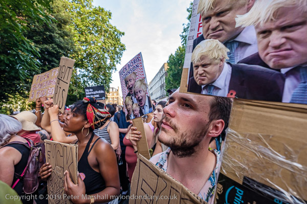
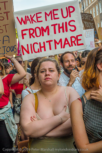
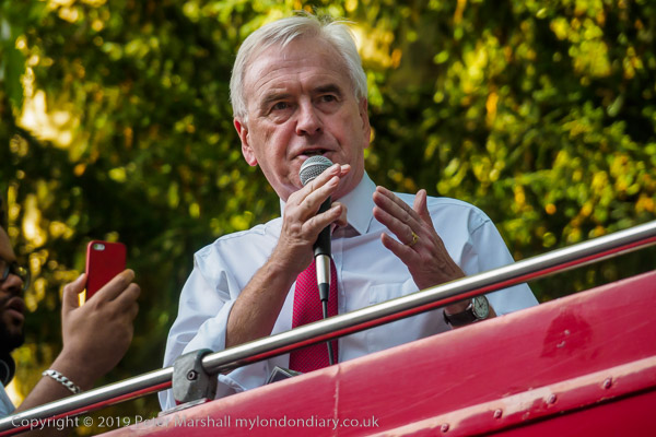
On 24th July the protest was not about the results of a general election, but of a Prime Minister who had been selected as the result of votes by Conservative MPs and then members of the Conservative Party alone, less than a hundred thousand peoplein all. It was difficult to argue against the conviction of the protesters that he had no mandate from the people.
Among those who spoke was the then Shadow Chancellor John McDonnell, and while I agreed with most of what he said, it was hard not to think that the reason we have such an unfair electoral system is that both major parties rather like its unfairness. It is rather harder for Labour to get MPs because of it, but it does mean that they have a better chance of an overall majority in those elections where they do well.
Of course the electoral system is only one factor that makes politics in this country unfair. We also have a system that allows the wealthy still to make huge political donations (and Labour benefits from the support of some trade unions, though on a smaller scale.) More important still is the way that we have a so-called ‘free press’ which is largely owned by a small group of billionaires who are allowed to get away with lies and misinformation about political parties, their policies and personalities.
It was Neil Kinnock, the Labour Party leader in 1992 who blamed The Sun as a major factor in his losing the 1992 election – it ended a long and relentless campaign of what he named as “misinformation and disinformation” with the famous election day headline, “If Kinnock wins today will the last person to leave Britain please turn out the lights.” And at the following election when The Sun had changed sides to back Tony Blair, the paper again made its claim “It’s The Sun Wot Won It“.
And while it isn’t hard to think of fairer alternatives to the current electoral system – including some that retain a constituency connection for most MPs with a list approach to redresses most of the electoral imbalances, it is rather harder to think of some way to redress the irresponsibly used power of the press. It would be nice perhaps to have some kind of publicly funded media organisation (perhaps through a licence fee) which devoted itself to fair and unbiased editing and reporting! Unfortunately Lord Reith is long dead.
The rally in Russell Square was extremely crowded and I got very tired, and went home rather than face the march to Downing St, where the protest got rather more interesting (and certainly even more photogenic.)
I’d been to Downing St earlier and things had been very quiet, and protesters I’d expected to see there had already left. If I’d been thinking clearly I would have realised that they would return later and taken the tube back to Whitehall rather than missing out on the action there.
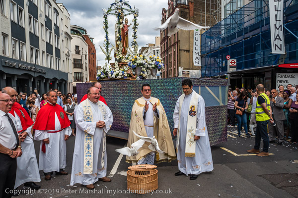
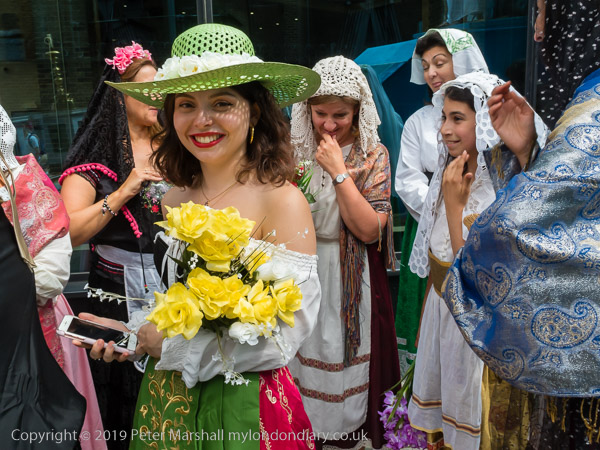
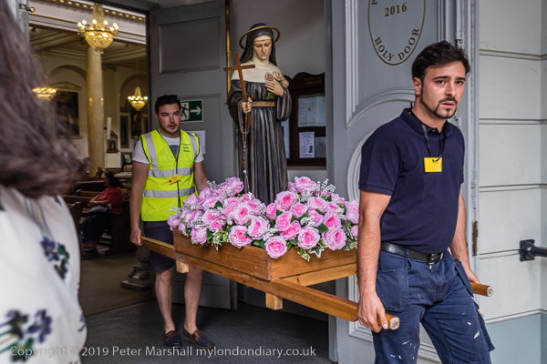
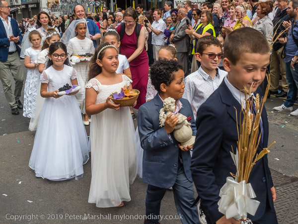
London’s big Italian festival which takes place every July in the streets around St Peter’s Italian Church in Clerkenwell is alway an interesting event, and one that although it has changed over the years since I first photographed it in the 1990s, still retains much of the same atmosphere and feel.
I always enjoy both the procession and the festival that accompanies it, which is apparently a much more recent addition to the event. When the festival first began in the 19th century – and special permission was needed for this Catholic procession – the area around the church had a large Italian population.
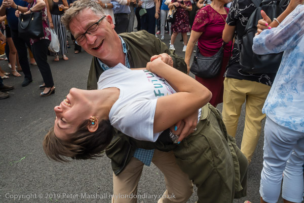
Now that population has moved away, with many in the suburbs or outside London and Italian communities come to the event from places like Watford, Luton and Woking, and the Sagra provides them with something to eat and drink and to meet people they may only see once a year at the event. And to dance.
It also provides something of a day out for myself and a few photographer friends, who take advantage of the cheap and reasonably priced Italian wine and sometimes the food too. THough rather more the wine!
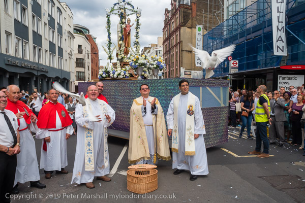
I was a little disappointed this year by the release of the doves, which for the last few years has been done by three clergy who were each given a dove to hold in their hands before releasing them more or less together. It was something they so obviously enjoyed. This year there were again three of the clergy, but all they did was stand behind the basket and watch as the lid was opened and the birds made their own way out.
It is always something of a challenge to capture the moment the doves fly, though I’ve usually managed to do so. It is of course made much easier with digital cameras, where you can use rapid sequences of exposures. Back in the days of film, few of us had motordrives, and we needed to wind on after each exposure. This meant you only had a single chance to get the picture, as by the time you had wound on the film the doves would usually have been high in the sky.
This year I took the picture with the Olympus E-M5MarkII using the 14-150mm lens at its widest setting, equivalent to 28mm. It was a bright sunny summer day and I set the camera to ISO 640 to get both a fast shutter speed to stop motion (1/400s) and a small aperture (f10) to get plenty of depth of field so that the background float with its statue of Our Lady would also be sharp. I say I set them, but in fact the camera was on ‘P’ setting and I simply checked it had suitable settings. As the moment approached I changed the camera into sequential shooting mode. I used the high setting which gives around ten frames a second.
One bird came out first and was several feet in the air before the other two emerged. The frame at the top of the post was my sixth and the last to show all three doves. There were I think 5 further frames with the last two doves, and the Exif data shows that I had taken 11 frames in just over a second. Using film I could have got at most two, though I would have hoped to get one that showed the peak of the action, I could well have missed it. Once the doves get going they can move extremely fast.
All photographs on this and my other sites, unless otherwise stated, are taken by and copyright of Peter Marshall, and are available for reproduction or can be bought as prints.
There are no adverts on this site and it receives no sponsorship, and I like to keep it that way. But it does take a considerable amount of my time and thought, and if you enjoy reading it, please share on social media. And small donations via Paypal – perhaps the cost of a beer – would be appreciated.
I think I joined the Greater London Industrial Archaelogy Society (GLIAS) in around 1979, forty years ago, but it had then been going for 10 years. I’ve not been the most active of members, particularly in recent years when I’ve been too busy with other things, but over the years I’ve been on numerous walks, several outings, attended talks and lectures and even made some tiny contributions. I still enjoy reading the newsletters and occasional publications of the group.
The various walks usually took me back to areas of London I’d already explored when taking photographs, and they often made me much better informed about buildings I had already photographed. I’ve not been on any lately as they almost always take place when I’m now working. But in previous years, the walks were often followed by the publication of small walk leaflets giving the route and pointing out the IA features.
The first of these walk leaflets was for Tower Hill to Rotherhithe and this anniversary event more or less retraced its steps, led by one of the two original authors, Prof David Perrett, now Chairman and Vice-President of GLIAS. It was a walk I’d first taken – without the aid of the leaflet – in the opposite direction back in 1983 (though I’d photographed parts of the area previously) and quite a few pictures from that are now online on my London Photographs site.
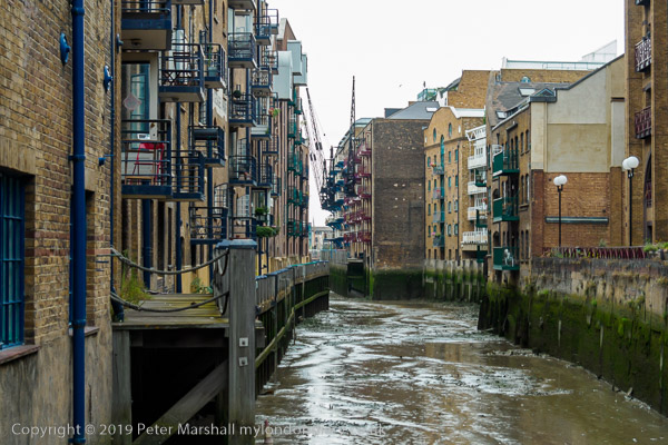
This area on Bermondsey Wall has changed considerably since then, though the riverside of Wapping seen at the top of the image still looks much the same. Of course you can’t see it from this same point, which I think is now occupied by expensive flats.
Inspired by these walk leaflets I went on to produce one of my own, a folded A4 sheet printed on thin card by my laser printer, largely as an exercise in Desktop Publishing which I was then teaching a course on.
Over the next few years I made and sold over well over 500 copies, charging I think 20p for each of them, though I never got the cash for some that were sold locally in Bermondsey (it rankled though the money was insignificant.) My best paying customer was a local historian who used them for several years for the guided walks he did on the local area. I think it is now seriously out of date, but ‘West Bermondsey – The Leather Area‘ has for a long time been available as a free download. (PDF)
The first time I put images from the area on line was in a site called ‘London’s Industrial Heritage‘, designed for me by my elder son, and you can see some pictures from this area from the links on the Southwark page.
I haven’t put many of the pictures from the walk on My London Diary, but there are a few more at GLIAS 50th anniversary walk. If you live in or around London and have any interest in industrial archaeology you would find GLIAS worth joining – and it has a very reasonable annual subscription of £14 (£17 for family membership.)
All photographs on this and my other sites, unless otherwise stated, are taken by and copyright of Peter Marshall, and are available for reproduction or can be bought as prints.
There are no adverts on this site and it receives no sponsorship, and I like to keep it that way. But it does take a considerable amount of my time and thought, and if you enjoy reading it, please share on social media. And small donations via Paypal – perhaps the cost of a beer – would be appreciated.