The fourth set of black and white pictures I took in London in 1980 together with the stories about them first published on Facebook.
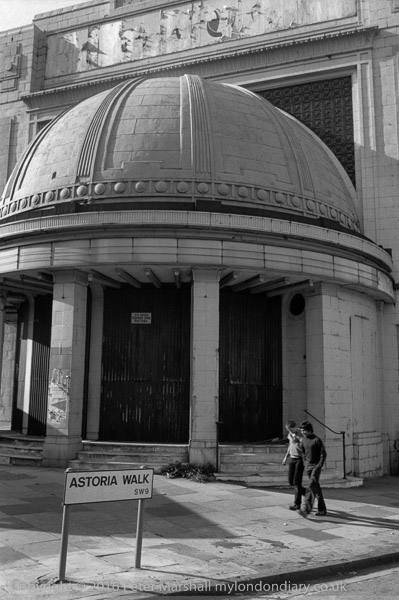
24g-45: venue, cinema,
http://londonphotographs.co.uk/london/1980/24g-45.htm
Brixton Astoria looks in fairly poor shape in this picture, with a notice warning there is a 24 hour dog patrol.
The building opened as a cinema and theatre in 1929, closing in 1972, becoming briefly a rock venue but closing in months. The Rank organisation wanted to demolish it to replace it with a garage and car showroom, but it is Grade II listed. They were using it as a store when I took this picture.
It reopened as a rock venue in 1981, but went bust, was bought for £1 and re-opened it as the Brixton Academy in 1983, becoming a success. Refurbishment in 1995 restored much of its original Art Deco features.
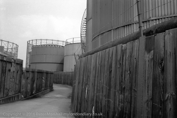
24h-31: footpath, fence, storage tank, gas holder
http://londonphotographs.co.uk/london/1980/24h-31.htm
The riverside footpath leads away from the river here, winding slightly around the oil storage tanks on its way to a bridge across the Blackwall tunnel approach. The northern area of the Greenwich Peninsula was at the time occupied by the Greenwich power station and gas works, as well as several wharves, including the Victoria Deep Water Terminal, where the footpath was marked out by yellow lines under the travelling cranes. You could walk through there by the river before the path led you between buildings to Tunnel Avenue, close to the brick tunnel entrance, always polluted and dusty. There was then no riverside path around the north of the peninsula, and the path only rejoined the river on Bugsby’s Reach having gone past The Pilot on River Way (a few yards south from where Pilot Walk now is.)
Only one of Greenwich’s gasholders remains, and that is currently threatened with demolition. Most of the storage tanks have now also gone. The riverside footpath which has been closed for some time while riverside flats were being built and work carried out on the river wall is now open, and you can now walk all the way from Drawdock Rd near North Greenwich station into Greenwich, as I did with friends a couple of weeks ago. Although the walk lacks much of the interest it had back in 1980, it still makes a pleasant walk – and you might see a seal, though we only saw some good pictures of one taken earlier by one of the building workers.
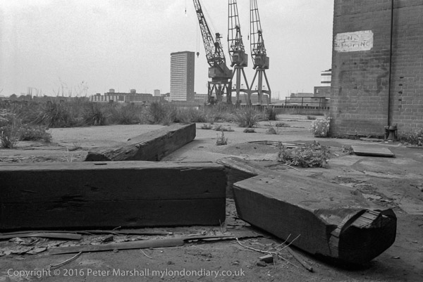
24h-33: dock, cranes,
http://londonphotographs.co.uk/london/1980/24h-33.htm
The tower block across the river is Kelson House on the Samuda Estate, 25 stories and 87m high and completed in 1967 with 144 flats for the LCC/GLC. Tower Hamlets Council privatised the estate in 2005 to a resident-led housing association which was taken over by One Housing Group in 2007. The estate takes its name from the shipbuilding company which was on the site from 1852 to the 1890s. Owned by Joseph d’Aguilar Samuda, it was the largest London shipbuilder in the 1860s. Later the site was used by various other industries until badly damaged by bombing in 1941. It was then used for storage until purchased by the LCC to build the estate.
I find it hard to identify now exactly where this picture was made on the riverside path, but I think it must have been on Bay Wharf and the cranes right of centre were those on the corner of the Victoria Deep Water Terminal.
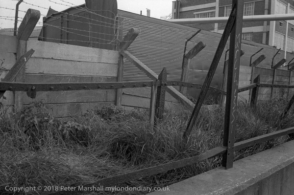
24h-43: works, path, fence,
http://londonphotographs.co.uk/london/1980/24h-43.htm
It was hard to see why there should be three separate fences (or the remains of them) with a narrow stretch of grass and weeds between them at the side of the riverside path. The most serious was at the back, with heavy concrete lengths between the concrete posts, with angled tops to support half a dozen runs of barbed wire. Clearly the lower rusted iron fence posts in front of this once supported something else from the bolts every few inches along the length of the horizontal members, while the foreground structure along the top of the wall must once have supported some chain-link fencing.
The picture was I think taken somewhere along by Morden Wharf or Enderby’s Wharf, but I can’t place it more precisely, though others may recognise the building in the background. Like almost everything else along this stretch of the river it will have been demolished and either already has been or soon will be replaced by expensive flats.
Lovell’s Wharf, Riverside Path, North Greenwich. 1980
24h-52: footpath, wharf,
Though I deliberately cut it down to ‘LOVE’ the writing on this wall was rather longer, reading I think ‘C. SHAW LOVELL’S LTD WHARF, with a second ‘LOVELL’S WHARF’ a few yards upstream. The signs were repainted a few years after I took this picture.
I’ve written earlier about this wharf, so here it is again (with minor corrections):
“The wharf remained in business until the early 1980s, when the increasing size of ships required a deeper berth. Until the 1840s this area of land was ‘The Great Meadow’ and belonged to Morden College. In 1838 they leased the land to William Coles Child who then ran his family’s coal trade business from Belvedere Wharf where the Royal Festival Hall now stands. They brought in coal to Greenwich from the north-east – Newcastle, Blyth, South Shields, Seaham – to the new ‘Greenwich Wharf’ and leased more land from Morden College, setting up coke ovens and a limekiln.
Coles also developed the streets close to the wharf, naming them after colleries in Durham. Pelton Rd got its name from Pelton Main and West Pelton collieries at Chester-le-Street in County Durham.
Greenwich Wharf became run by other companies, changing its name and in the 1920s the lease was bought by Shaw Lovell (now Bristol ICO Ltd) a family business from Bristol dating from 1869 who had been using the wharf since before the First World War. The renamed it Lovell’s Wharf, painting the name in giant letters on the wall beside the riverside path.
The two cranes are actually Scotch derricks. They were removed by Morden College in 2000, one of a number of of controversial aspects over the development of the site into “a contemporary riverside development” by bptw architecture for London and Regional Properties.”
The whole area was renamed by the developers as Greenwich Wharf and the riverside path, once open again, is much wider, but far less enticing.
Mary Mills has written in detail about Lovell’s wharf (and many other aspects of Greenwich’s Industrial History), and most of the information here comes from her Greenwich Industrial History blog.
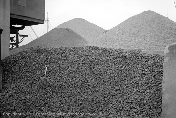
24h-54: wharf, gravel, fork
http://londonphotographs.co.uk/london/1980/24h-54.htm
Gravel Wharf was on the riverside just to the north of Lovell’s Wharf, with Piper’s Wharf just to the north of it, extending out over the riverside path. An alley, Cadet Place ran between Lovell’s and Granite Wharf, roughly where River Gardens Walk now is.
Looking at the mast and rigging behind the gravel heaps at left of picture, I think this must have been taken from Cadet Place.
I looked at that small hand form on the huge pile of stones and thought of the Augean stables; this must surely be one of the Labours of Hercules, though I doubt if even he would have cleared the pile in a day.
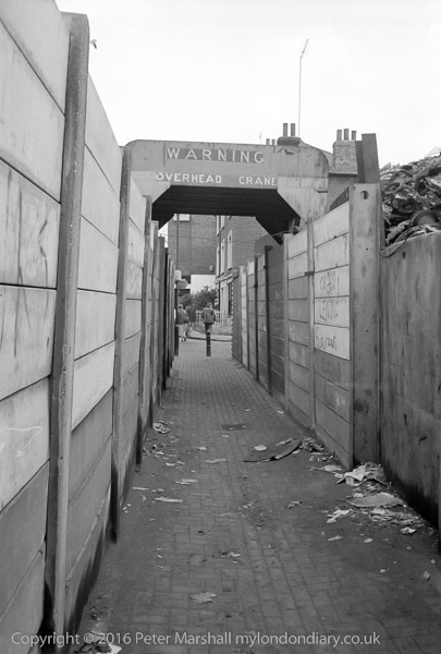
24h-63: footpath, scrapyard
http://londonphotographs.co.uk/london/1980/24h-63.htm
‘WARNING – OVERHEAD CRANE’ says the notice, and although the roof over the path was there to protect you from large chunks of scrap metal falling from the crane it was always wise to wait if it was operating overhead.
Through the arch, the path leads on to the houses still there on Ballast Quay and beyond them the side wall of the Cutty Sark pub (renamed when the Cutty Sark was brought to Greenwich, but a genuinely old pub, formerly called the Union Tavern’. It isn’t a bad place but gets rather crowded with tourists, and if you want to drink beer it is probably worth the short walk down Pelton St to the Pelton Arms, which also at times has live music (which may not be to your taste.)
The former scrap metal yard at Anchor Iron Wharf, Robinson’s Scrap Metal, was developed as luxury flats in 2003, with an area in front which Berkley Homes and Royal Borough of Greenwich agreed would be deemed public land and includes a seating wall and a few trees. However planning applications were made last year which would take part of this back as outdoor restaurant seating.
To be continued…
All photographs on this and my other sites, unless otherwise stated, are taken by and copyright of Peter Marshall, and are available for reproduction or can be bought as prints.
There are no adverts on this site and it receives no sponsorship, and I like to keep it that way. But it does take a considerable amount of my time and thought, and if you enjoy reading it, please share on social media.
And small donations via Paypal – perhaps the cost of a beer – would be appreciated.