I stopped putting new photographs on my ‘MY LONDON DIARY’ web site at the start of Covid, because there was little of much interest to add. But also for technical reasons, as I was getting rather close to the limit of number of files for the site of 262, 144 which is a restriction imposed by Linux.
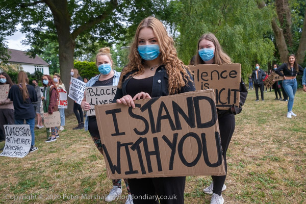
Black Livew Matter, Staines, June 2006
I was ill in March 2020, and although my symptoms didn’t match those then listed on the NHS site they did accord with some accounts by confirmed Covid victims. Fortunately they were not too serious, though I felt pretty poor for a week or so, and months later was still having problems going up hills. As a journalist I could have continued working during the lockdown, but since both my age and diabetes both increased my risks and I decided to keep away from London, crowds of any kind and meeting people indoors.
I didn’t just stay indoors, but took advantage during the lockdown to explore the area around where I live, taking bike rides of around 10 miles most mornings at a moderate speed. It was great for the first few months when there was little traffic, and our area was unusually quiet with few drivers on the three motorways and few jets taking off and landing at Heathrow. I spent a lot of time walking and cycling along the course of one of our smaller local rivers, finding places where I could photograph it. And I wore out the chainwheel of my vintage bicycle – for which I’ve only yesterday found a replacement in rather less used condition. And I’ve also put around 20,000 of my older images, mainly of London, onto Flickr.
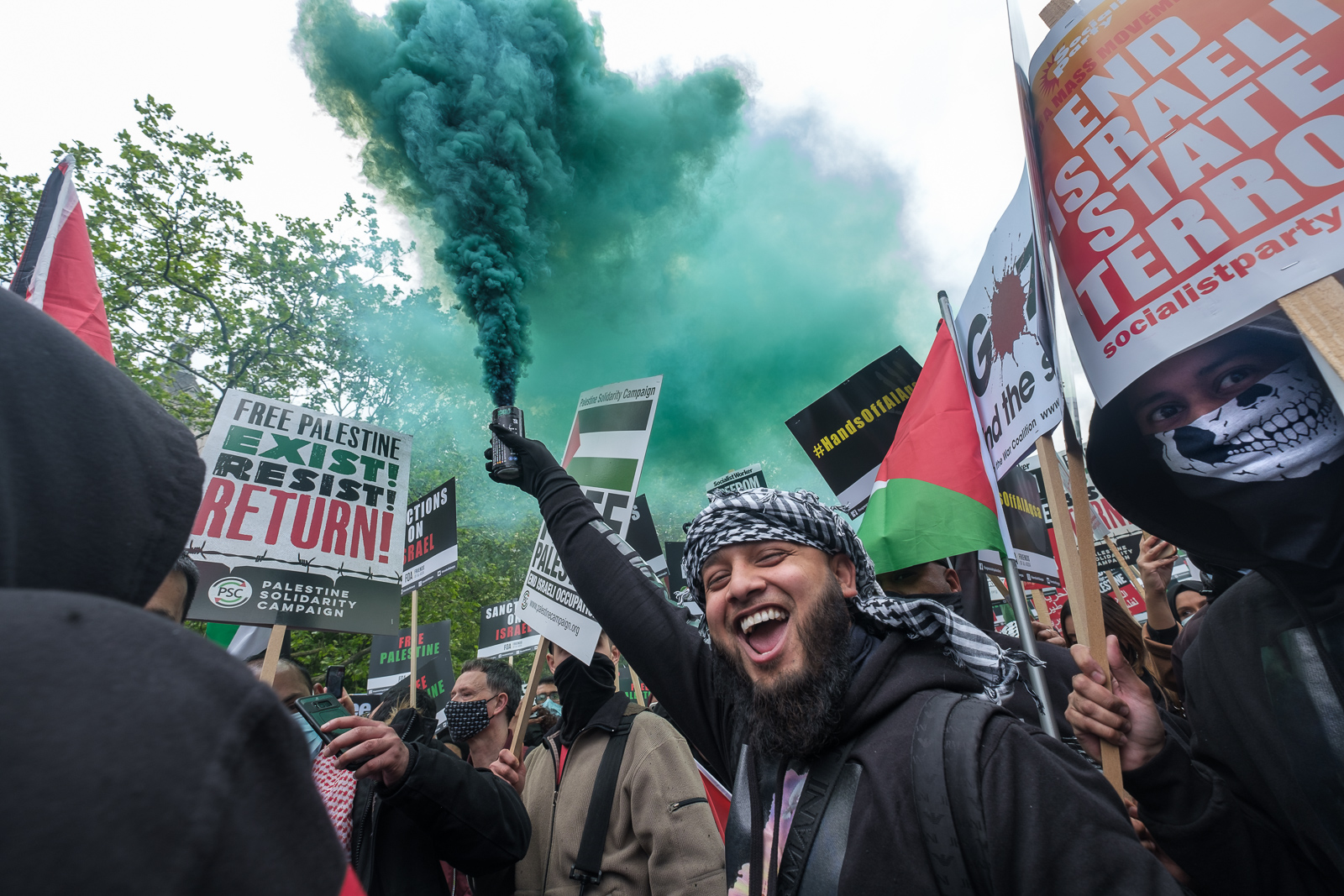
National Demonstration for Palestine, May 2021
Later came vaccinations, and a few weeks after my second jab decided I could stay home no longer, and I resumed work, though at a limited level on May Day 2021. But I still had not solved the problem about the file limit, so while I continued to upload pictures to the agency, I shared them with friends on Facebook rather than My London Diary.
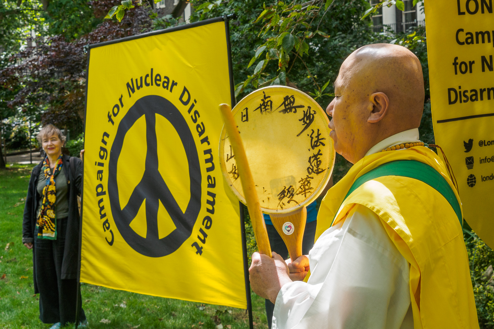
Hiroshima Day, August 2021
I had another problem too. I had been writing My London Diary on a Windows 7 computer and had now moved to Windows 10. I’d been using the same version of Dreamweaver for around 20 years for writing this and other sites, as it worked for what I needed. But to get a new version for Windows 10 would mean doubling my Adobe subscription – and giving me something far more complex than I need. I hunted for the setup disks thinking I might be able to get the old software working on my new computer, but couldn’t find them – then realised I had installed it from floppy disks which would have been thrown away when I no longer had a drive to read them.
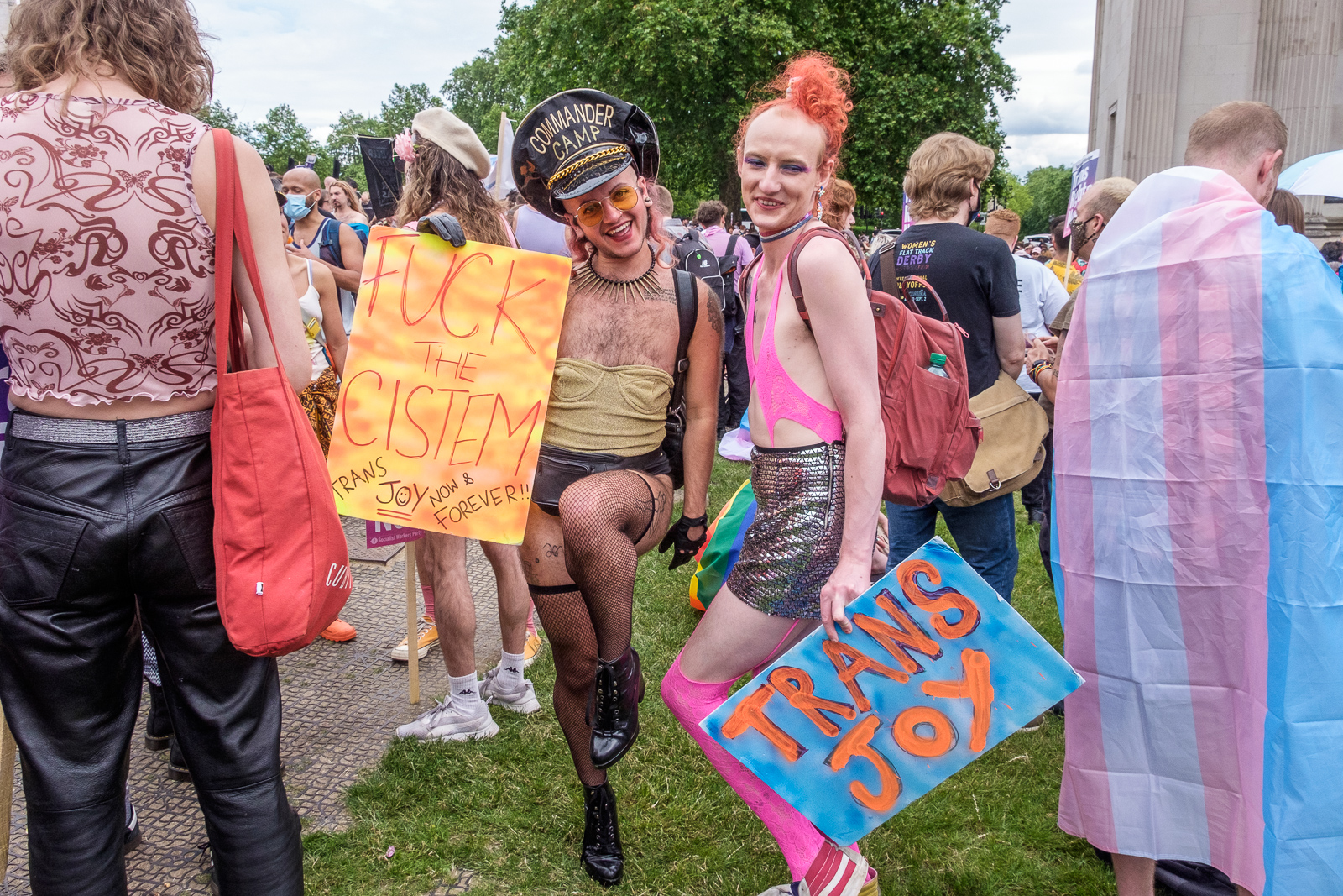
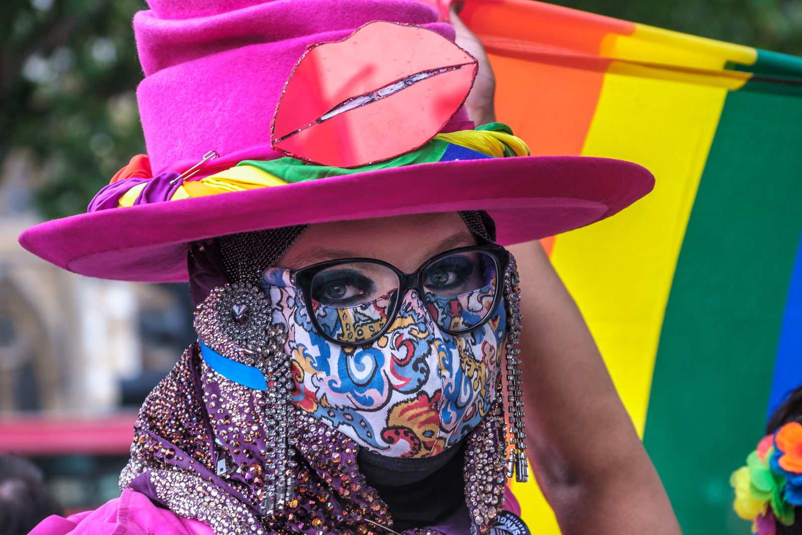
Trans+ Pride March, June 2021
I woke up in the middle of the night a few months ago and realised a part solution to my problems. Which was to make My London Diary a front end for those albums which I had posted on Facebook but which then rapidly disappear into its extensive bowels and are seldom if ever seen again. When I’m writing pieces for >Re:PHOTO I make many searches on Google, and pictures I’ve put on Flickr (with captions and keywords) often turn up, but I don’t recall ever having seen one from FB. But I can find them by scrolling down my many albums and they do have a URL. One advantage is that the images are much larger before, though you will only see this if you right-click on them and open them in a separate tab or downlad them.
Reclaim Pride, July 2021
So far I’ve only put a few month’s work on line, and it still isn’t fully integrated with the rest of My London Diary. Here’s the page for June 2020, and then for when I restarted in May 2021. The free (and open source) web editor BlueGriffon is a little clunky compared to my ancient Dreamweaver and lacks its library elements so I can no longer automatically update elements in a large number of files. I’m also having problems finding the images for some events – and had to make new albums for a few events for a year ago.
Continuing the series of post about the black and white pictures I made in 1980, with the pictures and the comments I posted more recently daily on Facebook.
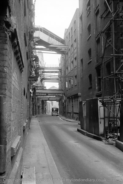
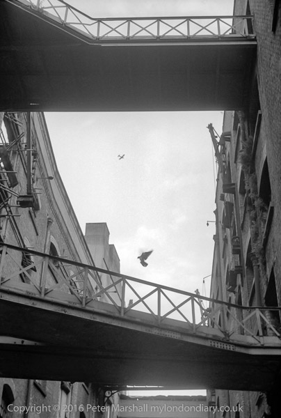
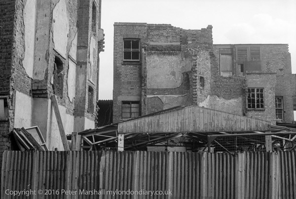
Shad Thames was in 1980 a truly remarkable street, a canyon between the riverside warehouses on the left of this view and their further premises linked by bridges across the street.
Work had just begun on some of the properties, but it took years to complete. The redevelopment has kept a little of the general character but seems to me to be an empty pastiche. My heart still sinks every time I go to the area.
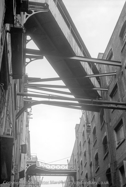
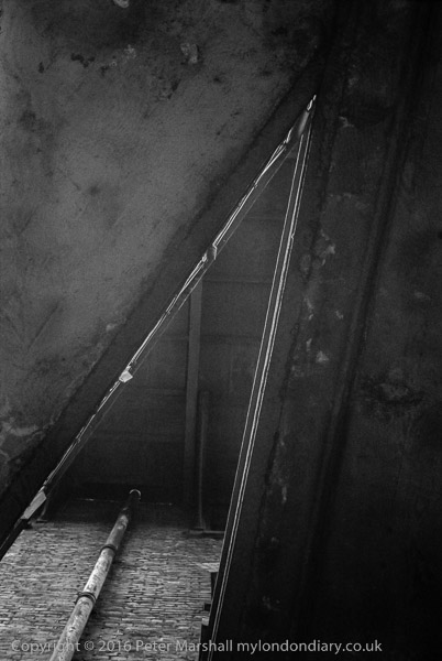
In this closer view you can see the girders supporting those bridges across Shad Thames, and also a number of pipes spanning the gap. Some of them may have been a part of the hydraulic power system which powered many of the cranes and hoists in the warehouses, avoiding the fire danger of other power sources. Fire was always a danger in warehouses, and one fire in 1931 when a seven storey warehouse full of rubber and tea was burning at Butler’s Wharf attracted great attention as ‘the Frozen Fire’. Around 70 fire engines and more than a thousand firefighters, along with two fire boats too several days to extinguish, with firemen working in snow and intense cold; large icicles formed on the buildings as the water ran down and it covered the roadway with sheets of ice.
You can see a remarkable story about it on the London Fire Brigade web site, complete with coverage from Movietone News.
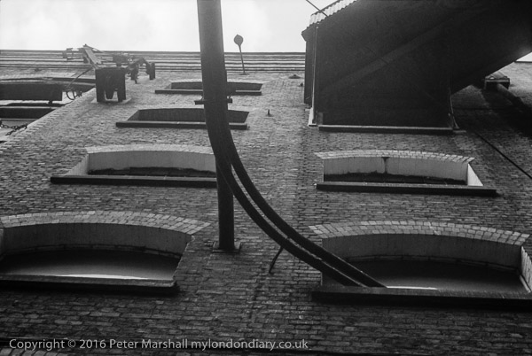
Another picture from Shad Thames, looking up, just a few yards down the street from the previous picture. Sometimes described as a ‘canyon’ it was a dark and fairly narrow street between the riverside warehouses and their landward companions.
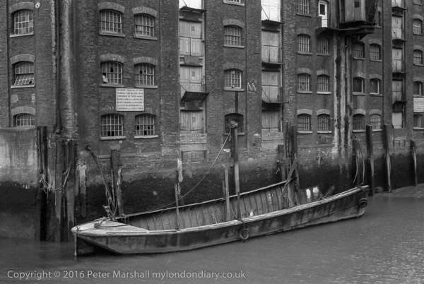
This paddle steamer was moored here in front of Butlers Wharf for some years, and I think may be the Tattershall Castle, once a ferry from Hull to New Holland across the Humber and now, very much altered, a floating bar on the Victoria Embankment on the north bank of the Thames. Before becoming a bar and restuarant she served some time on the Thames as an art gallery.
I’d been across the Humber once or twice on one of its fellow paddle steamers, the Lincoln Castle, a more modern design which continued in service for 5 years after the Tattershall Castle was retired in 1973. Later I had tea in the Lincoln Castle when it was a restuarant on the beach beside the Humber Bridge, whose opening in 1981 brought the ferry service to an end. I can’t recall having seen the Tattershall Castle in service.
The third of the Humber paddle steamers, built by the same yard as the Tattershall Castle also in 1934 was the Wingfield Castle, and was saved from becoming a bar in Swansea by being found too wide to fit through the lock gates and is now an floating exhibit in ‘Hartlepool’s Maritime Experience’, close to where she was built.
New Concordia Wharf, St Saviour’s Dock, Bermondsey, Southwark. 1980 24m-41: boat, dock, warehouse,
Again these buildings were only listed in 1982. Originally built as a cornmill and warehouse in 1882, they were rebuilt after a fire in 1894. I was fortunate to photograph them before they were converted to residential use in 1981-3
The notice on the wall reads “Mooring Facilities at these premises can be used when convenient by those having business here but the Proprietors do not guaranteed their sufficiency and accept no responsibility for the consequences of any defect therein“.
The barge moored here seems to have been cut off at the right hand end, and is apparently sitting on the mud.
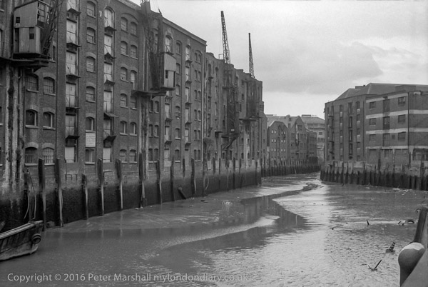
A view up St Saviour’s Dock before any conversion. There are four cranes on the wharf at left. There are still two cranes, but they look rather different, without the shelter for the workers, and the doors of the loading bays are replaced by balconies
Some of the buildings at right were later demolished and the frontages of most of the buildings altered in the conversion to residential use. The general impression however has been retained.
Continuing the series of post about the black and white pictures I made in 1980, with the pictures and the comments I posted more recently daily on Facebook.
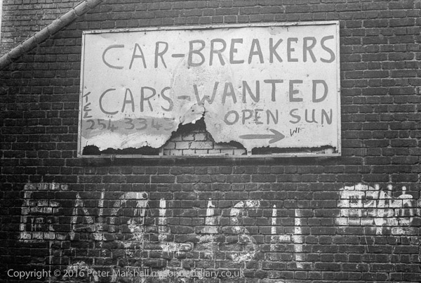
The sign for the Car-Breakers was on the steps on the south side of the footbridge from Cheshire St to Pedley St (or rather to Fleet St Hill at the end of Pedley St.)
What attracted my attention was clearly the word ‘ENGLISH’ painted on the wall, though I’m not sure why I cropped out all of the word below – you can I think make out the tops of the letters ‘OUT’.
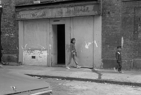
Childrens Corner, which may have once sold sweets but was no longer in business, was just off Brick Lane to the west, I think at 24 Bacon St.
Obviously I took the picture for the two Bangladeshi children who were walking past it, viewing me quizzically as I photographed them. The shopfront also has a crudely drawn swastika and the National Front initials, and was not far from where they would sell their papers at the weekend. The chalking at right for fireworks with prices was probably for a street stall on market day rather than the shop.
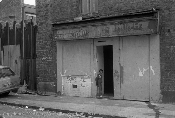
After I took the first picture, the young boy came back and posed in the former shop doorway for me to take his picture. The NF graffiti is more obvious in this picture.
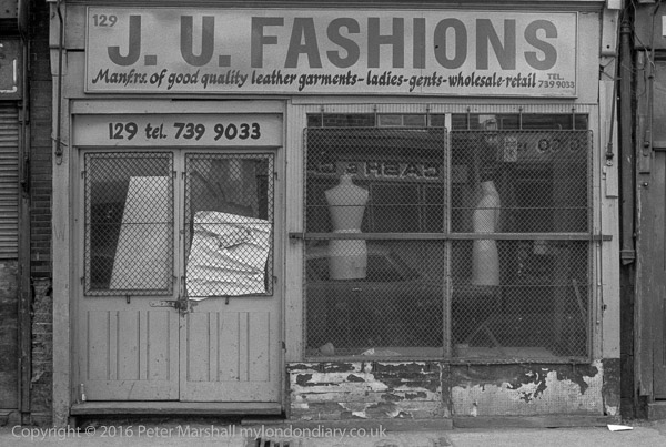
I think this shop was at 129 Brick Lane, not least as few other streets in the area aspire to a number as high as that, though 129 is now a part of a larger shop. The street numbering may of course have changed since 1980, but I think more likely the shopfronts have been rebuilt.
J U Fashions, ‘Manf.rs. of good quality leather garments – ladies – gents – wholesale – retail’ was I think one of the many Jewish businesses in the area in earlier years, and it claimed in a notice falling off the window of the left hand door “OUR PRICES …UNBEATABLE … E YOURSELF IN ONE”.
Brick Lane area, Spitalfields, Tower Hamlets. 1980 24l-64: derelict buildings,
This could be almost anywhere in the Brick Lane area where there were plenty of derelict buildings, but I think is most likely to have been on Buxton St.
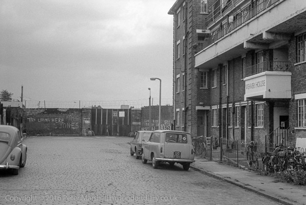
Weaver House on Pedley St was built by the Metropolitan Borough of Bethnal Green in 1929 with 16 flats. The road here used to be called Weaver Street, and the name reflected the area’s weaving industry which began with the Huguenots. It was part of the council’s third estate; the second built while the council was under joint Communist/Socialist control was named the ‘Lenin Estate’ but by 1929 the council was Liberal-Progressive and renamed that Cambridge Heath.
Weaver House was a part of the Hare Marsh council estate. Hare Marsh was the old name for large land estate south of Bacon St, once called Hare St and east of Brick Lane, most of which was covered by buildings in the 17th and 18th century. There there is still a short dead end street called Hare Marsh leading south from Cheshire St opposite the William Davis Primary School, which though outside the old Hare Marsh estate may have led there before the railway got in the way.
The wall at the end of this road is now longer there, and the road continues. ‘Try Living Here’ seemed an apt comment (I’m not sure if the Jones was a part of this) and at right I think it said ‘Our Kids Need Space’. Clearly this was Arsenal territory though close to the centre are clearly painted the stumps for a kids game of cricket.
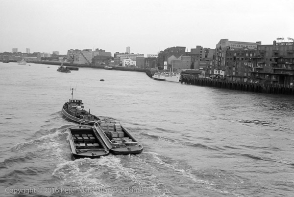
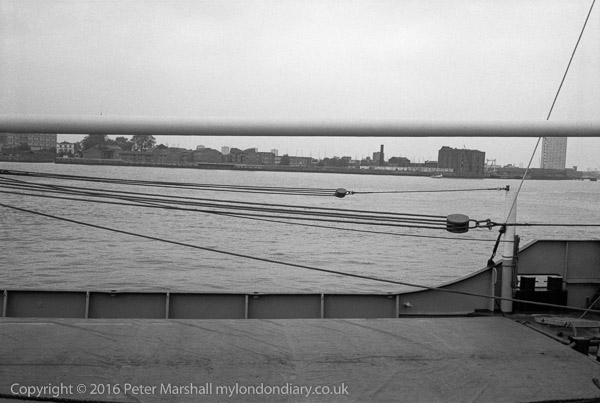
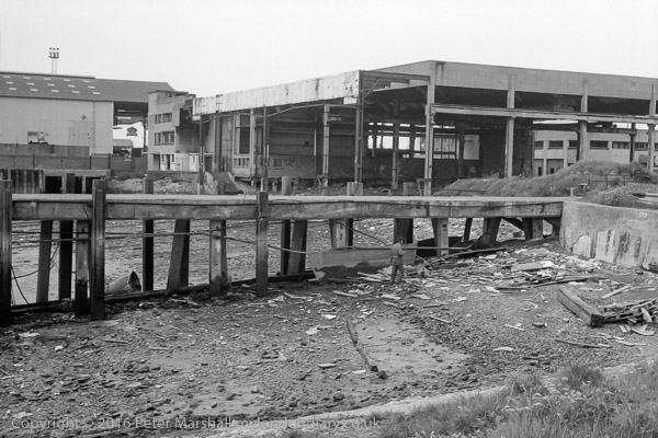
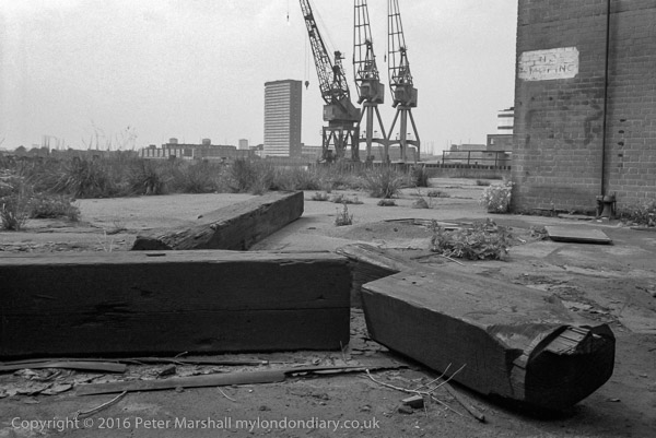
River Thames and Surrey bank from Tower Bridge, Southwark. 1980 24m-14: river, tug, barge, warehouse, wharf
Several things now strike me about this picture from Tower Bridge. Firstly the lighters are carrying real goods and not rubbish – about the only thing that gets towed along this part of the Thames now – and secondly the different look of the riverside then.
When Butler’s Wharf, a large area of Victorian warehouses dating largely from 1871-3 closed for business in 1971, much of it was bought up cheaply by property speculators, but little if any development had started by 1980. Some of the buildings were in use as artists’ studios, but after a disastrous fire in 1979 they were given notice to quit, and I think most of the buildings were empty when I took this picture.
Rather surprisingly these buildings appear not to have been listed until 1982 – and even now industrial buildings such as these seem often to be neglected by English Heritage.
Around 1984, Conran Roche began the redevelopment of Butlers Wharf into luxury flats, with restaurants and shops on the ground floor, though it was some years before the project was complete.
All photographs on this and my other sites, unless otherwise stated, are taken by and copyright of Peter Marshall, and are available for reproduction or can be bought as prints.
There are no adverts on this site and it receives no sponsorship, and I like to keep it that way. But it does take a considerable amount of my time and thought, and if you enjoy reading it, please share on social media. And small donations via Paypal – perhaps the cost of a beer – would be appreciated.
This was I think taken from Ballast Quay or Lovell’s Wharf, and some of the buildings which can be seen across the river are easily identified.
One, a white building is clearly the Great Eastern (though then it was the Watermans Arms) part of the Cubitt Town development built by William Cubitt it opened as the Newcastle Arms. It is a few yards from the Newcastle Draw Dock
It was writer and broadcaster Dan Farson who changed its name to the Watermen’s Arms when he became landlord in 1962 (though he hired a couple who had worked at Streatham Conservative Club to actually run it for him) featuring it in a TV programme about music halls. He did the place up and got a number of well-known entertainers to visit and sing at the place – including Judy Garland and Shirley Bassey – and other celebrities to come and listen and recorded a few episodes of his ITV series ‘The Entertainers’ there, but the audience proved too rowdy and later shows were made in a recreation of the pub in the studio.
Farson’s tenure only lasted a couple of years and after he left the pub quickly began to run down (perhaps partly because of high costs of ‘protection’ for businesses in the area), becoming a venue for striptease and drag artists, though still occasionally being used for TV and films, and it closed in 2011.
New management converted it into a pub and backpacker’s hostel – and renamed it to The Great Eastern. I walked past on a very hot day last year, hoping to take a rest there and have a pint, but as I approached a fight was taking place between two police officers and a man outside the door, and I decided to walk on.
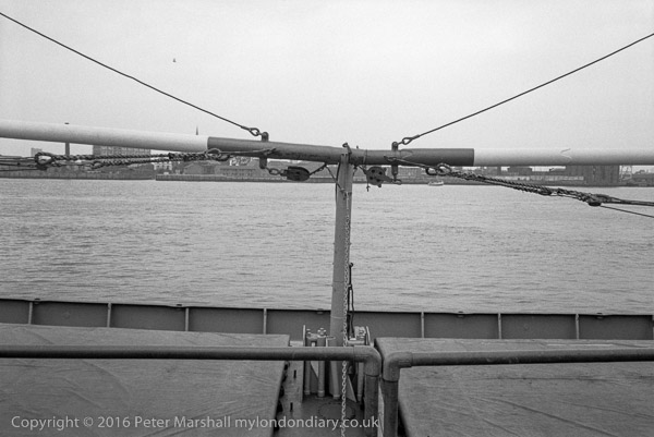
And just to the right you can see the spire of Christ Church sticking up above the spar.
River Thames and Millwall from Greenwich Riverside path, Greenwich. 1980 24h-66: river, ship,rigging
Another view from the same place shows a similar riverside vista, but this time extending to the tower block on the Samuda estate at the right. Apart from some housing not far from the Watermans Arms the rest of the buildings have I think been replaced by more recent developments.
River Thames and Millwall from Riverside path, North Greenwich, Greenwich. 1980 24j-15: river, rigging
For once I know exactly where this picture was taken, at Bay Wharf, and it is now the premises of a dry dock company, formerly at Pipers Wharf (now part of the site of the Greenwich Wharf development) immediately south of the former Victoria Deep Water Terminal, though I think all the buildings on the site have been demolished.
The man looking into the river had come with me along the riverside walk, and had wandered into the shed while I was taking other pictures.
Bay Wharf appears to have been the site of the Great Breach or Horsehoe Breach of the sea wall at some time before 1622. The area was owned by Morden College and in the mid 19th century Bay Wharf was leased to various industries, including American boat builder Nathan Thompson,and his company, The National Company for Boat Building by Machinery, which went bankrupt more or less immediately and the lease taken over by Maudslay Son and Field in or before 1864, and they used the site to set up a shipbuilding operation, mainly concentrating on screw powered steam ships, and including an experimental ship for Henry Bessemer whose small steel works were at what later became the Victoria Deep Water Terminal.
But they became better known for two iron hulled sailing clippers, Blackadder in 1870 and Halloween in 1871. Blackadder had a very chequered career, leading to a number of court cases, but both boats were record breakers – with Halloween making passage from Shanghai to London in 91 days, knocking 19 days from Cutty Sark’s best. Maudsleay didn’t remain for long as ship builders, but continued to make marine boilers for some years before going bankrupt in 1902.
The site was then leased to Segar Emery, an American mahogany importer, and around 1945 became home to Humphrey & Grey (Lighterage) Ltd, part of Hays Wharf. These derelict buildings were their barge repair slips.
Taken from within a few feet of the previous image at Bay Wharf, but with my back to the river, looking towards the gas works.
No 1 gasholder, 180ft tall and 250 ft diameter was the first ever built with four lifts, rather than three and was completed in 1888. It was in use until recently despite some minor damage by the IRA in 1980, It could hold 8.2 million cubic feet. No 2 holder, at left in the picture, wider at 303ft diameter, was built in 1890 and was the ultimate in frame guiding gas holders, with 6 lifts, two of them ‘flying’ above the guide frame and could hold 12 million cubic feet. The two flying lifts were damaged by the 1917 Silvertown explosion and removed, and the whole holder demolished in 1985.
No. 1 gasholder is currently still standing, though currently threatened with demolition. Only a few gasholders around the country were selected for listing and preservation, and presumably despite its novelty when constructed this was not judged of sufficient interest, though it is a decision hard to understand except on commercial grounds.
Another view of Bay Wharf, this time from the south of the breach, with the large shed on the site of the Maudsley shipbuilding works, though the building is much later, built as barge repair slips for Humphrey and Grey. The shed at left is I think a part of the Victoria Deep Water Terminal.
Mary Mills on her Greenwich Peninsula History web site mentions a jetty erected at Morden Wharf in 1859, which she says “it seems likely that this was in fact part of the area described under Bay Wharf” and I think this may be the jetty shown here.
As mentioned in a previous comment, Bay Wharf is now now the premises of a dry dock company, formerly around half a mile upstream, moved to facilitate the exploitation of the riverside there for expensive flats.
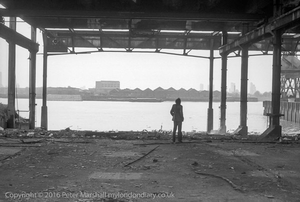
Disused Wharf, North Greenwich, Greenwich. 1980 24j-21: wharf, derelict,
All photographs on this and my other sites, unless otherwise stated, are taken by and copyright of Peter Marshall, and are available for reproduction or can be bought as prints.
There are no adverts on this site and it receives no sponsorship, and I like to keep it that way. But it does take a considerable amount of my time and thought, and if you enjoy reading it, please share on social media. And small donations via Paypal – perhaps the cost of a beer – would be appreciated.
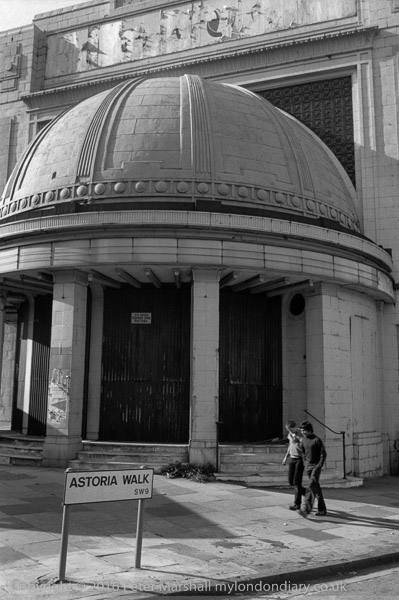
Brixton Astoria looks in fairly poor shape in this picture, with a notice warning there is a 24 hour dog patrol.
The building opened as a cinema and theatre in 1929, closing in 1972, becoming briefly a rock venue but closing in months. The Rank organisation wanted to demolish it to replace it with a garage and car showroom, but it is Grade II listed. They were using it as a store when I took this picture.
It reopened as a rock venue in 1981, but went bust, was bought for £1 and re-opened it as the Brixton Academy in 1983, becoming a success. Refurbishment in 1995 restored much of its original Art Deco features.
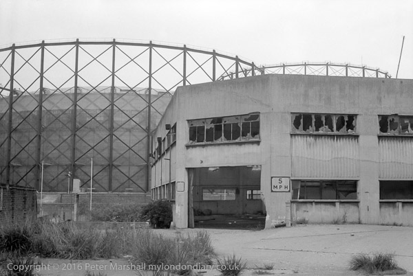
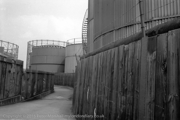
Footpath, Oil storage tanks and gas holders, North Greenwich, Greenwich. 1980 24h-31: footpath, fence, storage tank, gas holder
The riverside footpath leads away from the river here, winding slightly around the oil storage tanks on its way to a bridge across the Blackwall tunnel approach. The northern area of the Greenwich Peninsula was at the time occupied by the Greenwich power station and gas works, as well as several wharves, including the Victoria Deep Water Terminal, where the footpath was marked out by yellow lines under the travelling cranes. You could walk through there by the river before the path led you between buildings to Tunnel Avenue, close to the brick tunnel entrance, always polluted and dusty. There was then no riverside path around the north of the peninsula, and the path only rejoined the river on Bugsby’s Reach having gone past The Pilot on River Way (a few yards south from where Pilot Walk now is.)
Only one of Greenwich’s gasholders remains, and that is currently threatened with demolition. Most of the storage tanks have now also gone. The riverside footpath which has been closed for some time while riverside flats were being built and work carried out on the river wall is now open, and you can now walk all the way from Drawdock Rd near North Greenwich station into Greenwich, as I did with friends a couple of weeks ago. Although the walk lacks much of the interest it had back in 1980, it still makes a pleasant walk – and you might see a seal, though we only saw some good pictures of one taken earlier by one of the building workers.
Disused Wharf, North Greenwich, Greenwich. 1980 24h-33: dock, cranes,
The tower block across the river is Kelson House on the Samuda Estate, 25 stories and 87m high and completed in 1967 with 144 flats for the LCC/GLC. Tower Hamlets Council privatised the estate in 2005 to a resident-led housing association which was taken over by One Housing Group in 2007. The estate takes its name from the shipbuilding company which was on the site from 1852 to the 1890s. Owned by Joseph d’Aguilar Samuda, it was the largest London shipbuilder in the 1860s. Later the site was used by various other industries until badly damaged by bombing in 1941. It was then used for storage until purchased by the LCC to build the estate.
I find it hard to identify now exactly where this picture was made on the riverside path, but I think it must have been on Bay Wharf and the cranes right of centre were those on the corner of the Victoria Deep Water Terminal.
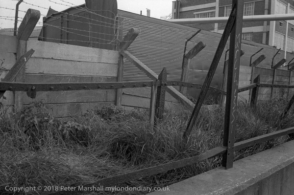
Riverside path, North Greenwich, Greenwich. 1980 24h-43: works, path, fence,
It was hard to see why there should be three separate fences (or the remains of them) with a narrow stretch of grass and weeds between them at the side of the riverside path. The most serious was at the back, with heavy concrete lengths between the concrete posts, with angled tops to support half a dozen runs of barbed wire. Clearly the lower rusted iron fence posts in front of this once supported something else from the bolts every few inches along the length of the horizontal members, while the foreground structure along the top of the wall must once have supported some chain-link fencing.
The picture was I think taken somewhere along by Morden Wharf or Enderby’s Wharf, but I can’t place it more precisely, though others may recognise the building in the background. Like almost everything else along this stretch of the river it will have been demolished and either already has been or soon will be replaced by expensive flats.
Lovell’s Wharf, Riverside Path, North Greenwich. 1980 24h-52: footpath, wharf,
Though I deliberately cut it down to ‘LOVE’ the writing on this wall was rather longer, reading I think ‘C. SHAW LOVELL’S LTD WHARF, with a second ‘LOVELL’S WHARF’ a few yards upstream. The signs were repainted a few years after I took this picture.
I’ve written earlier about this wharf, so here it is again (with minor corrections):
“The wharf remained in business until the early 1980s, when the increasing size of ships required a deeper berth. Until the 1840s this area of land was ‘The Great Meadow’ and belonged to Morden College. In 1838 they leased the land to William Coles Child who then ran his family’s coal trade business from Belvedere Wharf where the Royal Festival Hall now stands. They brought in coal to Greenwich from the north-east – Newcastle, Blyth, South Shields, Seaham – to the new ‘Greenwich Wharf’ and leased more land from Morden College, setting up coke ovens and a limekiln.
Coles also developed the streets close to the wharf, naming them after colleries in Durham. Pelton Rd got its name from Pelton Main and West Pelton collieries at Chester-le-Street in County Durham.
Greenwich Wharf became run by other companies, changing its name and in the 1920s the lease was bought by Shaw Lovell (now Bristol ICO Ltd) a family business from Bristol dating from 1869 who had been using the wharf since before the First World War. The renamed it Lovell’s Wharf, painting the name in giant letters on the wall beside the riverside path.
The two cranes are actually Scotch derricks. They were removed by Morden College in 2000, one of a number of of controversial aspects over the development of the site into “a contemporary riverside development” by bptw architecture for London and Regional Properties.”
The whole area was renamed by the developers as Greenwich Wharf and the riverside path, once open again, is much wider, but far less enticing.
Mary Mills has written in detail about Lovell’s wharf (and many other aspects of Greenwich’s Industrial History), and most of the information here comes from her Greenwich Industrial History blog.
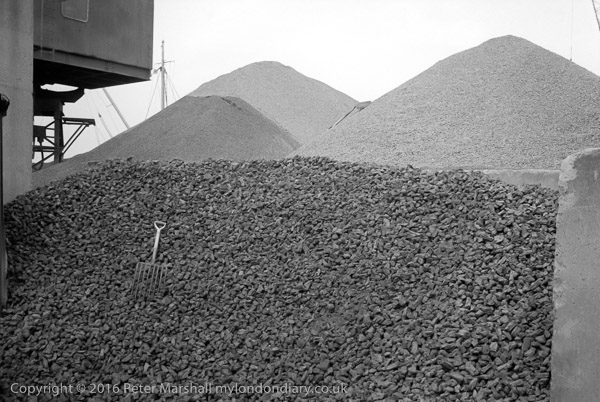
Gravel wharf, North Greenwich, Greenwich. 1980 24h-54: wharf, gravel, fork
Gravel Wharf was on the riverside just to the north of Lovell’s Wharf, with Piper’s Wharf just to the north of it, extending out over the riverside path. An alley, Cadet Place ran between Lovell’s and Granite Wharf, roughly where River Gardens Walk now is.
Looking at the mast and rigging behind the gravel heaps at left of picture, I think this must have been taken from Cadet Place.
I looked at that small hand form on the huge pile of stones and thought of the Augean stables; this must surely be one of the Labours of Hercules, though I doubt if even he would have cleared the pile in a day.
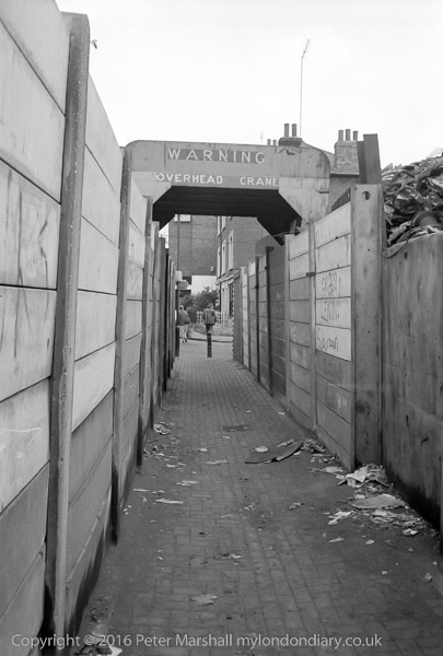
‘WARNING – OVERHEAD CRANE’ says the notice, and although the roof over the path was there to protect you from large chunks of scrap metal falling from the crane it was always wise to wait if it was operating overhead.
Through the arch, the path leads on to the houses still there on Ballast Quay and beyond them the side wall of the Cutty Sark pub (renamed when the Cutty Sark was brought to Greenwich, but a genuinely old pub, formerly called the Union Tavern’. It isn’t a bad place but gets rather crowded with tourists, and if you want to drink beer it is probably worth the short walk down Pelton St to the Pelton Arms, which also at times has live music (which may not be to your taste.)
The former scrap metal yard at Anchor Iron Wharf, Robinson’s Scrap Metal, was developed as luxury flats in 2003, with an area in front which Berkley Homes and Royal Borough of Greenwich agreed would be deemed public land and includes a seating wall and a few trees. However planning applications were made last year which would take part of this back as outdoor restaurant seating.
To be continued…
All photographs on this and my other sites, unless otherwise stated, are taken by and copyright of Peter Marshall, and are available for reproduction or can be bought as prints.
There are no adverts on this site and it receives no sponsorship, and I like to keep it that way. But it does take a considerable amount of my time and thought, and if you enjoy reading it, please share on social media. And small donations via Paypal – perhaps the cost of a beer – would be appreciated.
Taken, again on the Minox, on a family outing to Brixton to an Open Day at the windmill which was then being restored. I didn’t take any black and white pictures of the windmill, but I think I may have taken a camera with colour film and made some family pictures with that, though I can’t at the moment find them.
We’d walked around Brixton in a slightly indirect way to get to the windmill, and on the way home I suggested another diversion, coming out from Blenheim Gardens and going across Brixton Hill to one of the roads opposite, perhaps Josephine Avenue.
A few years later I tried to go back and find this basement, but could not locate any properties in the area with similar short steps from the pavement up to the front door and down to a basement below. It may still be there somewhere, perhaps a little further away than I remember, or it may have been demolished.
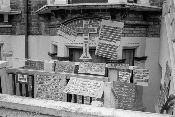
I’d hoped to find it again, and perhaps to have stepped over the wall and gone down the steps to the door at the right and rung on the bell and found out more about the person who painstakingly created all of these signs with their curious mis-spelling such as ‘THE OLD WRAGGID CROSS’
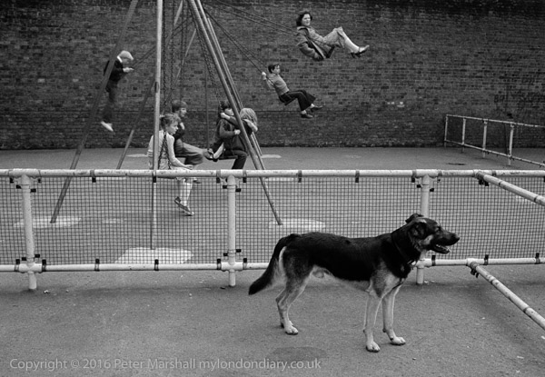
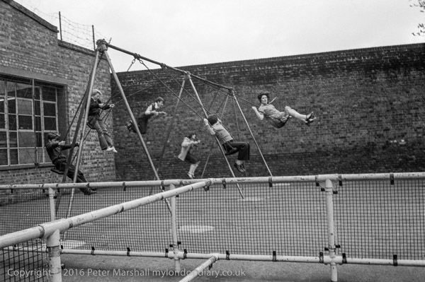
I think this playground was close to Brixton Windmill in Blenheim Gardens. I had come with my family to visit the Windmill. My two young boys were too young to go on these swings even had they not been in used, and the dog didn’t seem too friendly.
It is a typical old-fashioned playground made when kids were made of tougher stuff and minor injuries from falling on tarmac and concrete were taken for granted.
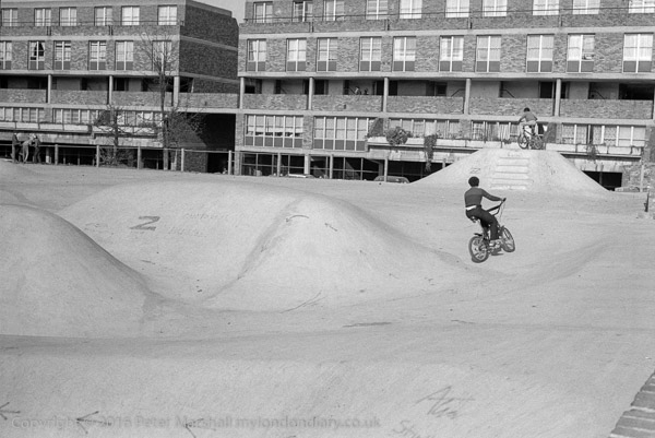
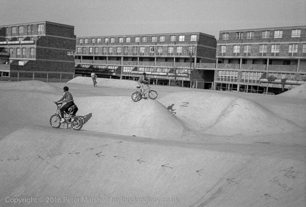
Stockwell Concrete Bowl Skatepark is still there at the corner of Stockwell Rd and Stockwell Park Walk, along with the flats behind on Benedict Rd, Barrett House, part of the Stockwell Park Estate, which was completed in 1976.
The estate got a bad reputation, particularly following the 1981 Brixton riots, though it was one which, despite some crimes which got wide coverage in the scandal sheets, it never really deserved.
These flats were pretty new when I took this and several other pictures, as was the skatepark. The skatepark is now an “Asset of Community Value”, and street art from it was featured on the reverse of a Brixton Pound note commemorating Lenford (Len) Kwesi Garrison (1943 – 2003), co-founder of the Black Cultural Archives. The flats were refurbished in 2014 and considerable attempts have been made to improve the estate, including a very expensive CCTV system and much gardening.
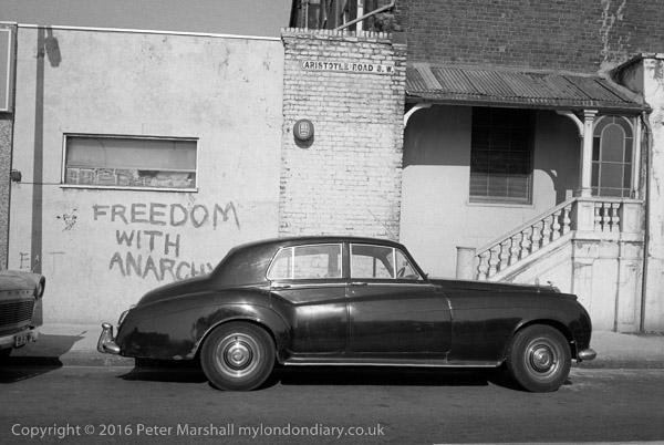
Freedom With Anarchy, Aristotle Rd, Clapham, Lambeth. 1980 24g-14:
Who could resist going to photograph Aristotle Road – and finding there this graffiti ‘Freedom With Anarchy’?
“Anarchism has but one infallible, unchangeable motto, “Freedom. Freedom to discover any truth, freedom to develop, to live naturally and fully” according to US anarchist, writer, labour organiser and IWW founder Lucy E Parsons (1853-1942), a remarkable woman who was probably born a slave, though she claimed only Native American and Mexican descent. Chicago police described her as “more dangerous than a thousand rioters…”
Books have been written about Aristotle’s concept of freedom, and according to the Oxford Handbook of Freedom he thought that “a person is free to the extent that he is able to live a life of politics and philosophy, and a polis is free to the extent that its institutions promote such a life for each and every citizen by removing the impediments to its realization“.
You can still recognise the location, just off Clapham High St, at the rear of Pearl Pharmacy though the balustrade, roof and stained glass have gone, the road name with its old S.W. is still on the wall. The car parked there back in 1980 was a little unusual, and is I think a T-Series Bentley. I thought at the time it looked a suitable motor for gangsters.
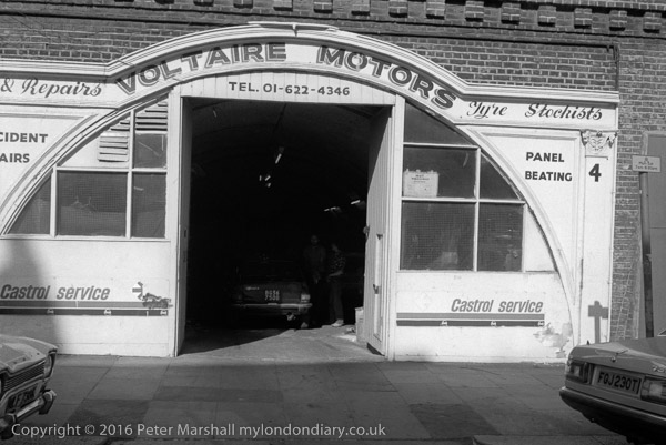
Not far from Aristotle Rd is Voltaire Rd, which runs from Clapham High St alongside the railway line and includes Clapham High Street station. Railway arches used to be cheap business properties including many garages such as Voltaire Motors but times are changing. These arches were refurbished around ten years ago and seem now to be largely Artisan Coffee Bars, bars and eateries. I think the arch which used to house this garage became The Bridge Cafe.
Voltaire Motors actually looked considerably better than any of the small row of businesses that now occupy these arches; although the interiors may have been improved by refurbishment the outside has certainly deteriorated since 1980.
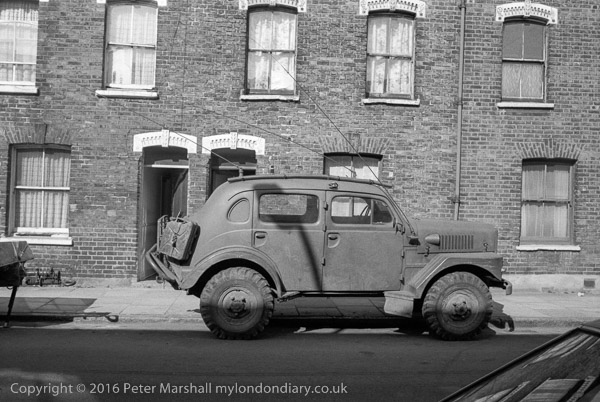
From the fairly distinctive decorations above the upper floor windows and doors I think this picture was taken in Lendal Terrace, off Clapham High St, alongside the railway on the other side of road and railway from Voltaire Road.
Experts in military vehicles will probably recognise the vehicle parked here, with a high wheelbase for going off-road. It looks American to me, and vaguely like a Humvee, but I’m almost certainly wrong.
All photographs on this and my other sites, unless otherwise stated, are taken by and copyright of Peter Marshall, and are available for reproduction or can be bought as prints.
There are no adverts on this site and it receives no sponsorship, and I like to keep it that way. But it does take a considerable amount of my time and thought, and if you enjoy reading it, please share on social media. And small donations via Paypal – perhaps the cost of a beer – would be appreciated.
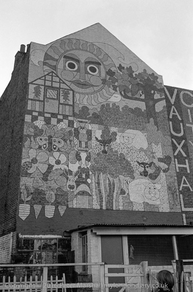
The mural announcing the presence of Vauxhall City Farm has I think long gone, and there has been considerable development of the buildings there. It now seems to me obviously to be a picture I should have taken in colour, and possibly I did, though quite likely I had only a single camera with me loaded with black and white film.
This picture was taken on a Minox EL, a tiny 35mm camera hardly large enough to take the film cassette, with plastic case whose front folded down pulling out the lens into position. Said to be the smallest 35mm camera in the world, it had a 35mm f2.8 lens, weighed only 200g and fitted into even a shirt pocket. For over 20 years one of these cameras (I got through 3 or four) went with me more or less everywhere.
They weren’t cheap (they were distributed by Leica in the UK) and were tricky to use, and the auto-exposure was often unreliable – later I found it worked better if you held the camera upside-down. The first one I bought just couldn’t take sharp pictures, and I sent it back to Leica, who wrote a rather snooty letter saying there were no performance specifications for the lens, but did exchange it for one that was tack-sharp. A few years later, that stopped working after it jumped out of my pocket when I was cycling to work and I got it replaced on insurance (and a hefty jump in premiums the following year.) When I had to send that one back to Leitz they said it was beyond economic repair but sold me a replacement at cost.
The Russians liked the Minox 35mm cameras so much they produced their own exact copy, the Kiev 35A, and I expect their spies still carry one on their visits to English cathedrals.
Rather more buildings along the riverside are now visible across Vauxhall Pleasure Gardens from Tyers St than when I took this picture, but the backs of the houses on Kennington Lane are still recognisable, and the shops along their front have changed only a little to reflect the increasing gentrification of the area – at had at least last time I walked along there from the station to take a camera in to Fixation. The buildings on the green have also been replaced by a newer block along Glyn St.
The area in the distance, where only two blocks of buildings appear has become one of the fastest growing areas in London. I think the block right of centre might be the Nine Elms Cold Store, closed in 1979 but not demolished until the late 1990s, but cannot identify the block at left. There are now high rise buildings covering almost the whole of Nine Elms with more still being built. Along with expensive flats for foreign investors there is also expensive student housing built to lower standards but equally tall.
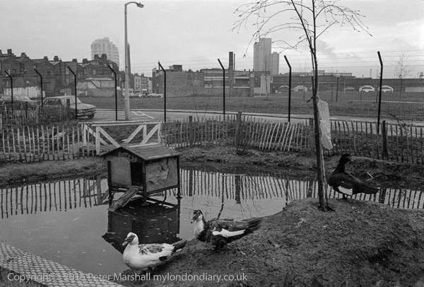
I think the duck pond with its duck house (presumably less ornate than MPs can afford on their expenses) has also gone, with new building on the City Farm site and an expansion of the farm estate.
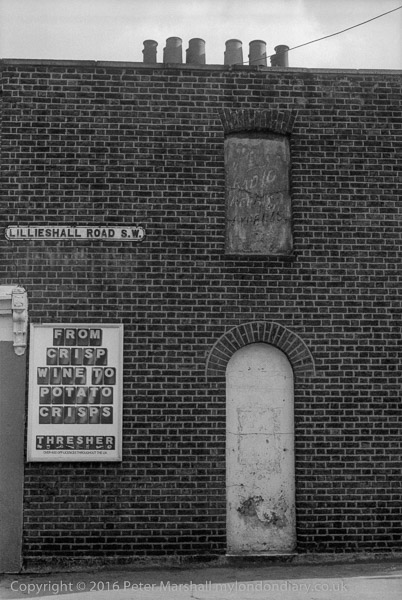
The house here was clearly a corner shop in use as an off-licence and it can still be seen on the corner with North St, though now simply housing. The adverts, including that covering the window at right, are long gone.
It was that faded upper sign advertising ‘RADIO REPAIRS’, and under it what I think must have once been the word ‘EXPERTS’ above the blanked out doorway that attracted me to take the picture of what was otherwise a very ordinary Victorian working-class building, typical of the area.
I’m surprised I didn’t take a picture of the whole side of the building, which actually has three such doors in a row, only the central one in use, each with a window above. But probably only the window in my picture was covered by advertising, and I suspect that the lens on my Leica simply did not have a wide enough view to show all three.
I also failed to photograph the now listed former “Tim Bobbin” pub, just down Lillieshall road, named after the Lancastrian schoolmaster, caricaturist and dialect poet who called himself the Lancashire Hogarth, and was a schoolmaster and notorious drinker born in Urmston who lived and died in Milnrow on the edges of Rochdale, where he is buried in St Chad’s Churchyard, his gravestone carrying the epitaph “Jack of all trades…left to lie i’th dark” he wrote for himself minutes before his death.
I don’t know why he should be celebrated by a pub in Clapham (there is one in Burnley too) nor why the owners should have decided around ten years ago to change the name to ‘The Bobbin’ and replace his rather pleasant portrait on the pub sign to a rather less interesting silhouette.
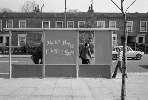
Death to Fascism, Bus Shelter, Battersea, Wandsworth. 1980 23t-32: house, graffiti,
I can’t at this remove remember why I was wandering around South London taking pictures with the Minox on a day in April 1980, but I’m fairly sure I had not gone out with the main intention of taking pictures, otherwise I would have picked up the Leica or possibly my Olympus OM-1.
There must have been some other reason for my being there, and obviously having some time to spare. One possibility is that I had gone early and decided to walk from Queen’s Road Battersea to a meeting or exhibition at the Photo Co-op in Webbs Road in Clapham, which had started the previous year, rather than take the shorter walk from Clapham Junction.
As usual at the time I have no record of exactly where I was, and this street is fairly typical of many of the wider streets in the area, with its late Victorian housing. Only the main roads are this wide and have a pavement where I could get back far enough to make a picture like this with the 35mm lens.
I suspect I will have waited some time, not for the bus, but for people at the bus stop to arrange themselves rather better in the frames provided, but with little luck, and I think made this exposure as the bus the bus was about to arrive, knowing they would board.
Obviously it was the graffiti that attracted my attention. The large white letters of ‘DEATH TO FASCISM’ are easy to read in this small image but the smaller black ‘Kill A BLACK TODAY’ is perhaps harder to read.
This is a section of a terrace somewhere in the Park Town estate in Battersea, around Queenstown Road, built up from the 1860s by James Knowles junior, one of London’s early organised and managed estates. Though well conceived it was not a great financial success, as the middle-classes for whom it was intended rather looked down on the pollution from the adjoining railways to north and east, and the estate was then re-purposed towards more working class artisan tenants.
Probably this property – a ‘six-roomed’ house – with external decoration to make it look rather grander than it was – was built as the three flats the doorbells now indicate, one on each floor. Much has been written about the estate, which led down to the rather grander buildings of Cedars Road and the North Side of Clapham Common.
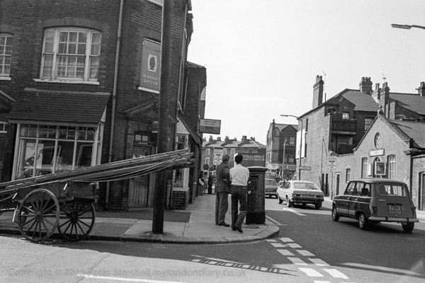
Broughton St, Battersea, Wandsworth. 1980 23t-53: house, pub, church, hall
This corner of Broughton St and St Philip St, looking towards Queenstown Road is still recognisable, though the Market House pub is now a private house and the RIdley Hall at the right of the picture has been rebuilt as Ridley Hall Evangelical Church, though in a similar design.
I took two frames with the Minox, with a fairly similar composition, but while the other was a little more upright, this is sharper. They were obviously taken within a few seconds, though the film wind on the camera was rather difficult to do at any speed, as neither the two men on the street corner or the group further down the street appear to have moved, but the cars are a few yards further down the road in the other image.
The ladders on the handcart reminded me of my father who often used a similar conveyance to take his ladders, paint, tools and occasionally beehives around Hounslow (and sometimes further afield) until his retirement in the late 1960s. By 1979 this was becoming rather less common, though one still saw window cleaners and others who had not yet acquired vans.
I’ve written recently about Facebook’s censorship of posts and many of my friends who are on Facebook (and more who I don’t know but are ‘Facebook Friends’) seem regularly to disappear for a few days or even permanently having been banned from FB. (Though most of those who have been permanently removed seem to reappear in a few days under a slightly different name.
Often their ‘offences’ seem to have been trivial or non-existent, sometimes just sharing a link to an article in the mainstream press seems to be enough to generate a ban. At times FB’s arbiters seem excessively prudish, objecting to the kind of language that is commonplace in many groups in our society, or in their obsessive fear of women’s nipples.
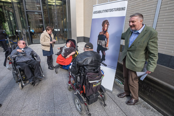
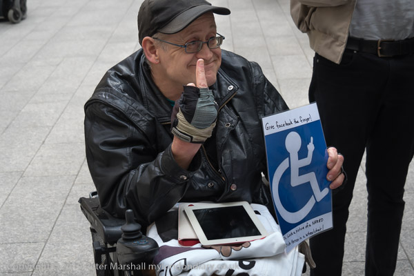
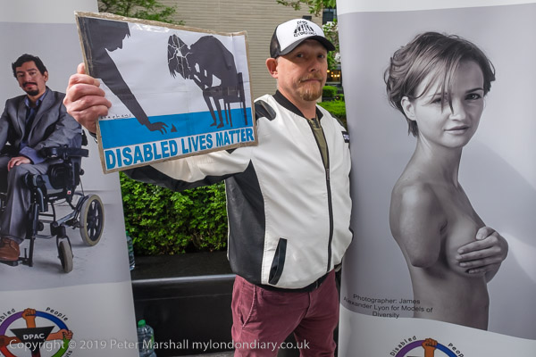
FB’s censorship reached a shameful new low a few months ago, when they blocked people recording ‘Likes‘ on the site of Access Ability who have a Facebook help line to empower people with disabilities. When this was queried on a phone call, the site was told the action had been taken by FB because “some people find it disturbing to see pictures of disabled people“.
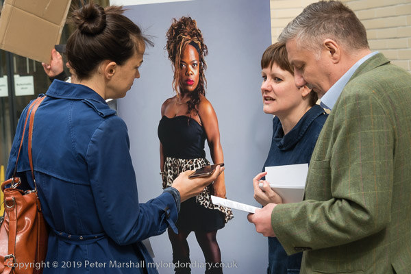
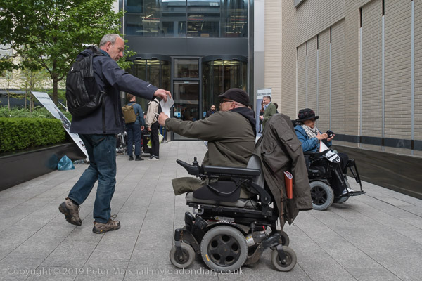
Together with a colleague I went to photograph a protest by disabled friends from DPAC (Disabled People Against Cuts) outside Facebook’s London HQ against this discriminatory treatment by Facebook of disability-related pages, and you can see my pictures of their protest. During the protest they played a recording of the phone call which the above quote came from, and there were other similarly disturbing statements.
But what you can’t see pictures of is a meeting which I think took place between the protesters and a manager from Facebook about the ban. FB were clearly so ashamed about their behaviour that they were unwilling for this to be recorded. Their security manager came out and told DPAC that a manager would only come out and talk with them if the meeting was not photographed, videoed or recorded in any way.
My colleague had already left, deciding he had enough pictures of the protest for his newspaper which had asked him to cover it. I decided not toprejudice the outcome of the event for the protesters and felt that reporting the prohibition was a more powerful admission of FB’s guilty shame than any photographs of the meeting could be and left.
All photographs on this and my other sites, unless otherwise stated, are taken by and copyright of Peter Marshall, and are available for reproduction or can be bought as prints.
There are no adverts on this site and it receives no sponsorship, and I like to keep it that way. But it does take a considerable amount of my time and thought, and if you enjoy reading it, please share on social media. And small donations via Paypal – perhaps the cost of a beer – would be appreciated.
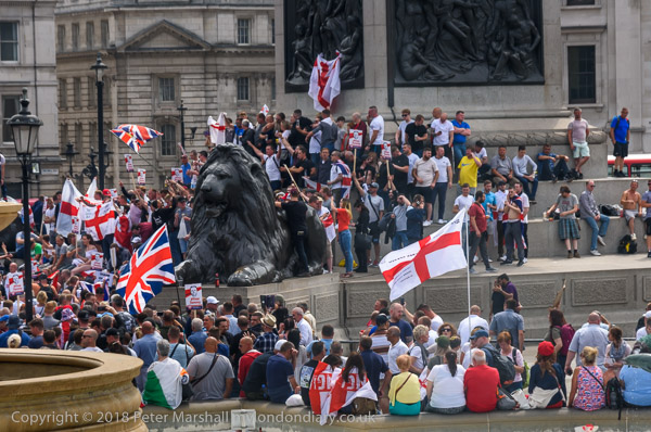
Around ten days ago for the first time I got a notification from Facebook that one of my pictures had been reported as being against ‘community standards’ and had been taken off-line.
It was a picture in an album of pictures from the June 2018 ‘Free Tommy Robinson’ protest in London, I think this image.
Certainly one of the pictures from when the protesters were gathering in Trafalgar Square before marching down to a rally in Whitehall. This picture was taken from the North Terrace overlooking the square, after which I walked down and took a few more from the edge of the crowd, as well as a few closer pictures.
You can see more of my coverage of the event at Free Tommy Robinson on My London Diary. After the pictures in Trafalgar Square I photographed the protesters as they walked down Whitehall towards the stage for the rally, and was in the crowd close to Downing St when I was attacked by two men who tried to pull my camera out of my hands.
I struggled, pulling away and twisting and moving away through the dense crowd and they followed, one continuing to grab my camera and pull it away, and the other grabbing my other camera which was on a strap at my right side, and at my camera bag on my left shoulder. Fortunately the straps held and though the bag was pulled off my shoulder I had my arm through the strap and was able to drag it behind me along the ground, moving closer to the police at Downing St and the march stewards.
I think a few of the other protesters in the crowd were also telling the pair of thugs to stop, though none actually came to my help. But when they saw the police looking at them they let go of me and my cameras and rushed away. I was shaken but not injured, and the cameras were OK, and managed to take a few more pictures before I decided I really needed to move somewhere safer and recover.
I suspect that what had triggered the complaint to Facebook about the picture – I think the first of the set – was nothing in the picture, but that in the captions I had written about this attack on me. I’ve always tried to report accurately on protests, including those by right-wing groups, both in text and pictures, and this is anathema to many on the right. Some of whom are thugs on-line too.
Of course I requested a review of the removal – as the notification from Facebook had told me I could, and only 70 minutes later got a message thanking me for asking for review and informing me they had decided the image did not breach community standards and was back on line. Good to see the review system can work – but surely the system should look at complaints and see if there is any basis for them before taking action.
I mention this because I’ve just read a post by Jörg M Colberg on his Conscientious blog, Your Post Goes Against Our Community Guidelines: An Algorithmic Rewriting of History about the rather more serious censorship of his and other posts on Instagram, which is owned by Facebook. Like me he contested the removal of a picture he posted – one from the Abu Ghraib archives – and his post was also restored. In the post he points out the problems and dangers of internet censorship:
It doesn’t really matter whether it’s a government that’s censoring photographs or the algorithms of a US corporation — censorship is censorship, and these kinds of developments do not bode well for us.
I think there should be some control over content on platforms such as Facebook and Instagram, to remove clearly illegal content. Things like hate speech, terrorist propaganda, threats of violence etc. It’s perhaps difficult to see how this could be applied in content that is shown in many different legislations, but that is a problem for those who profit from these platforms to resolve, and might involve serious changes in the services and their profitablity. But because it’s difficult doesn’t absolve them from their responsibilities, though it may demand different models.
All photographs on this and my other sites, unless otherwise stated, are taken by and copyright of Peter Marshall, and are available for reproduction or can be bought as prints.