Back in the 1930s there were at least five Albert Roads in London, along with a number of Albert Streets, Albert Mews etc and the authorities embarked on an orgy of renaming to sort out the confusions that could arise. Albert had been particularly popular after Prince Albert of Saxe-Coburg and Gotha had married Queen Victoria in 1840 and at the time of his death in 1861, and some, such as Consort Road, were renamed to reflect their original dedication.
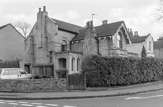
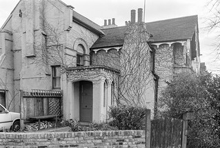
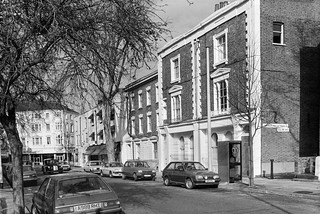
15 Consort Road is Grade II listed and described as “Mid C19, recently restored” and it rather looks as if my picture was taken during that restoration, with the house in excellent condition but the garden rather lacking. Its listing is perhaps more about its part in a group of similar houses rather than its individual merit, and 11,13 and 17 are also listed.
Rather better known now is its new neighbour, 15 and a half Consort Road, an long, low and unobtrusive house now alongside the right hand side of this house with a wood-covered frontage extending a little closer to the road. From the front it rather looks like a garage which someone forget to put in the door, but it was a truly innovative building by Richard Paxton Architects in 2002, shortlisted in the RIBA Awards 2006, and featured on TV’s Grand Designs.
Two railway lines with three bridges cross Consort Road just a few yards from each other, one leading from Peckham Rye to Nunhead and the other from Peckham Rye to Queen’s Road Peckham, along which is now planned to build an urban linear corridor park, the Coal Line, which I visited in 2015.
The bridges and the area around them have changed considerably since 1989. But I think the viaduct is of the line to Nunhead and this house on the edge of the workhouse site has since been demolished.
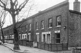
Limited were in a post-war building on Consort Road just a little south of the railway bridges and I think they made waterproof products using rubber on glass cloth. Their building replaced some older Victorian terrace housing, some of which was still there at the right when I made this picture. I think the company under a slightly different name is still in business elsewhere.
These buildings have all been replaced by modern flats and an industrial unit.
This shop was obviously on a street corner, almost certainly one of the four corners with Consort Road and Brayards Rd. I was interested in the shapes and the tiling as well as the fly posting and crude graffiti – which appears to be two practices at producing the final result at right, perhaps a stylised ’68’. The doorway with a rusticated keystone seemed unusually tall and narrow. It was probably Victorian although the shopfront seemed later.
The Gold Diggers Arms was a sizeable pub on the northeast corner of Brayards Road and Consort Road and was still in business when I made this picture. It had been here since at least 1871, but closed in 2001 and was demolished in 2005. The site is now a modern development, Dayak Court, flats above ground floor commercial premises.
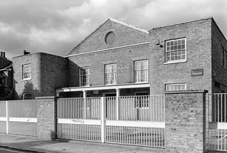
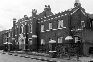
The Hooper Hall, Consort Rd, Peckham, Southwark, 1989 89-2f-53
Hooper Hall at 111 Consort Road opened as a mission of St Mary Magdalene in St Mary’s Rd in 1907, which was destroyed by a land mine in 1940. Worship continued here and in the church hall while money was raised to build a new church, opened in 1962 and itself replaced in 2011. The mission has lasted rather better.
A notice tells us that in 1989 it was used by both St Mary Magdalene and the Peckham Christian Fellowship. Later it became home to the Christ Miracle Gospel Ministries International but was put up for sale in 2012, and I think the church moved to Edmonton. A fence was put up around Hooper Hall around 2015 as if building work was about to begin, but little seems to have happened since. It appears still to be available for sale.
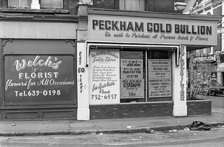
Peckham Gold Bullion, Peckham High St, Peckham, Southwark, 1989 89-2e-26
Peckham Gold Bullion has “We wish to Purchase all Precious Metals & Stones” above the shop windows and a great deal of elaboration on notices in and on the windows below. I don’t know when the ‘EST 50 YEARS’ was painted proudly on the column at left, but the business must have been going since at latest the 1930s.
This shop, at 38 Peckham High Street on the corner of Bellenden Road is currently a mobile phone shop and internet cafe, also offering money transfer, travel agency, computer repair etc. Welch’s Florists is also long gone, its window covered by advertising for the phone shop.
Jones & Higgins, Peckham High St, Peckham, Southwark, 1989 89-2e-11
Jones & Higgins opened their first small shop on Rye Lane in 1867 which grew into the large and well-known department store. The magnificent building by local architects Henry Jarvis & Sons on the corner of Rye Lane and Peckham High St dates from 1894, and the company developed down Rye Lane as far as Hanover Park, though the property on the corner there was leased to a bank (and still is a bank.) The department store closed in 1980 and by the time I made this picture the upper floors were in use as the Peckham Palais nightclub which closed around 2010, leaving much of the building unoccupied and deteriorating – and for some time a part of it was a brothel. There is a long and detailed YouTube video on the history of the site, and the shop which was built when Rye Lane Peckham was a shopping centre to rival Oxford Street. The section on Jones and Higgins begins around 19 minutes in.
Part of the store, including the orginal shop had already been demolished for the unnecessarily ugly The Aylesham Centre a small part of which is at the right which opened in 1988. There are currently plans to redevelop this eyesore including a massive 27 storey block which are opposed by local campaign group Aylesham Community Action (ACA).
This huge monolithic development along Queens Road was the Wood Dene estate, a part of the Acorn Estate built in the 1960s. It was demolished in 2007, its fate possibly hastened after the shocking murder of a woman, Zainab Kalokoh, who was holding her baby holding her baby at a christening in the estate’s community centre when shot by teenage gang robbers.
When the two joined blocks of 323 council homes were demolished in 2007 promises were made to 173 ‘temporarily’ decanted tenants that they would be allowed to return to the new homes on the site.
But the site was sold off on the cheap by Southwark Council to Notting Hill Housing Trust who originally promised to include around 116 social housing homes in the 333 new homes to be built on the site, now called Peckham Place. The housing association, now Notting Hill Genesis, took 12 years to complete the development, largely spent in bargaining the number of social homes in the scheme down to 54. But eventually they failed to provided any at all, with those 54 being marketed as “affordable” homes.
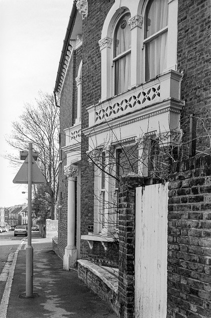
Queen’s House, close to the corner of Queen’s Road and Wood’s Rd attracted my attention because of the unusual layout of its windows, with four on the first floor and only three symmetrically above, as well as its very solid-looking porch. This Grade II listed building is thought to date from around 1725.
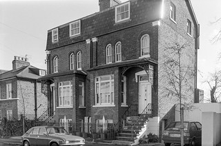
Another Grade II listed building, described as “Terrace of 3 houses, now shops and offices. c1700, with later alterations” and listed as 6,8 and 10 Queen’s Road.
It now looks rather better with the shopfronts removed, though as often the frontage is decorated by a large number of wheelie bins. The Surgery building at left is still there.
This house is also Grade II listed and thought to be late seventeenth century with alterations from around 1820. I’m unsure if the factory buildings and chimney behind were a part of Carty’s works which as my picture shows were ‘MAKERS OF VATS & WOODEN TANKS’ but think they are probably those of another company. There was at one time a sauce and pickle manufacturer in this area.
The house and yard behind was more recently occupied by a scaffolding company, but now the whole area around the house, including the Tuke School and the factory buildings has been cleared as far as Cossall Park has been cleared and rebuilt as housing and the listed house renovated.
You will look in vain for this school on Bellenden Road now. The school, a special school, moved to a shared site with Archbishop Michael Ramsey School,Camberwell in 2013 leaving the building empty. It was demolished in 2015 and replaced by Cherry Garden special school, which moved out of Bermondsey to here.
I’m unsure as to the date of this school, though it was clearly postwar, possibly dating from the 1960s. Perhaps surprisingly it was not mentioned by Cherry and Pevsner in their London 2: South volume though it seemed to me to be clearly of architectural interest. Southwark Council described it as “a distinctive post-war school” but wanted to knock it down so went on to say “it is not of sufficient quality of construction nor is it sufficiently unique to warrant the particular protection given by listing“. I can’t comment on the structural soundness from the four pictures I took but can’t think where you can find a similar building. It gets a rather deprecating comment in the Holly Grove Conservation Area Appraisal, “Highshore School, immediately adjacent to the conservation area, was built using standardised lightweight constructional systems and open site-planning principles which undermine the established morphology of street frontages“, not fitting in neatly with the Georgian housing in the area.
House, Highshore Rd, Elm Grove, Peckham, Southwark, 1989 89-2e-33
This house is on the corner of Higshore Road and Elm Grove and I think its address is 64 Elm Grove. It is certainly a very impressive and substantial late Victorian house with a quirkiness I found appealing enough to take a second frame.
Post Office Depot, Highshore Rd, Peckham, Southwark, 1989 89-2e-35
I didn’t photograph the listed houses in Highshore Road, perhaps suffering from a surfeit of rather standard Georgian or early Victorian houses in the area. Fine though they are I didn’t feel a need to photograph all of them.
The Post Office Depot is rather less usual and carries a ‘Historic Southwark’ board as well as being Grade II listed. This is possibly the earliest building in what was then known as Hanover Street, built in 1816 as the Friends Meeting House, apparently on the site of a pond. It was considerably enlarged in 1843.
Shops, Rye Lane, Peckham High St, Peckham, Southwark, 1989 89-2e-21
These buildings are stll there at the north end of Rye Lane, though now with different shops, but almost all the buildings visible on Peckham High Street in the picture have gone. There is still a bank at 65 Peckham High Street the extreme corner of which can just be seen but the rest of the buildings including the Midland Bank have gone, with a walkway here now leading to the Peckham Pulse Leisure Centre built in 1998.
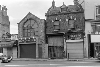
Shops, Peckham High St, Peckham, Southwark, 1989 89-2e-22
I took another picture of these shops from a slightly different viewpoint to one I had made a month earlier which I wrote about aat some length in a post on that earlier walk. The building housing ‘Stiletto Ecpresso’ has been replaced since 1989 by a taller and rather less interesting structure but the rest still look much the same, though with different uses.
Canal Head, Peckham High St, Peckham, Southwark, 1989 89-2e-23
Had I been aware of the changes that were soon to take place in this area I would have made more than this picture at Canal Head. This was the start of the walk along the route of the Peckham Branch of the Surrey Canal, at the back of what is now the The Drovers Arms, roughly at the south-east corner of the more recent Leisure Centre.
Doorway, Peckham High St, Peckham, Southwark, 1989 89-2e-24
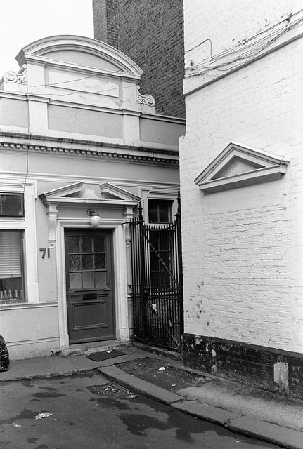
The Drovers Arms has the address 71-79 Peckham High St and tucked away down a short driveway at its read is this building at 71, now a dental surgery, Peckham Dental Care. The building at right with a bricked up and painted over doorway is the pub, which has a rather grander and more useful entrance on the High Street, opened in 2000.
The main building at 73-79 was built around the end of the 19th century, according to Historic England by architects J & J W Edmeston, for the London and South Western Bank. The Edmestons were a family of architects working in London, of whom the best known was probably James Edmeston Jr (1823-98). I think 71 may be a little earlier.
At the end of Lyndhurst Grove I came to Lyndhurst Way and had to make the choice of whether to turn left or right along it. Both ways looked interesting but I chose left and found a short terrace or four rather unusual houses at 13-19, two of which had the decoration on the window bays. There are also differences in the treatment of the doorway and windows of these two houses, which are the only ones of the four with entrances leading down to the pavement – those at the end of the block have their doors at the sides.
I continued to Lyndhurst Square then turned back, walking down Lyndhurst Way to Holly Grove, taking a few pictures on the way, none of which are online.
House, Holly Grove, Peckham, Southwark, 1989 89-2e-55
Holly Grove was developed by George Choumert (1746-1831), a Frenchman who married Lydia Fendall from a wealthy family of tanners in Bermondsey. He had a number of houses built in what was then George Lane around 1815-20. This picture shows No 14 and 15 – the houses are numbered consequently as there are no houses on the north side of the road which is Holly Grove Shrubbery, ‘a Victorian shrubbery with a serpentine boundary with a footpath winding through it’ between Holly Grove (then South Grove) and Elm Grove. All the houses from 5-24, 32 and 33 are Grade II listed.
Peckham Indoor Market was built around 1938 or shortly after as Rye Lane Bargain Centre with an imposing frontage for a narrow arcade leading back to a large covered market. It’s a style that rather makes it look like a cinema. Across the top is the message ‘Come Rain Or Shine It’s Always Fine at Peckham Indoor Market’.
In the early 2000s the market at the back was reduced in size with part now redeveloped as flats but the front section remains and is now Rye Lane Market, housing over 50 small shop units.
Rye Lane Chapel, Rye Lane, Peckham, Southwark, 1989 89-2e-41
You can read a detailed history of the chapel up to 1927 on the web. The first Baptist worship in the area was begun around 1817 when Mr Spencer, a deacon from Blackfriars Baptist church moved into what is now Peckham Hill St, a more rural location, for the sake of his health and began services in his home. Soon the congregation got too large for this and they bought a plot of land on Rye Lane and built a large and expensive chapel on the corner of Blenheim Grove and Rye Lane which opened in 1819.
Unfortunately when the railway came the chapel was exactly where it ran and the railway company were to build their station. So the chapel had to go, and a new chapel was built on the opposite side of the road a short distance to the north in 1863. That one was built on a firm concrete foundation and is still standing and still in use, having been restored after wartime bomb damage.
Houses, Elm Grove, Peckham, Southwark, 1989 89-2e-43
I turned back west from Rye Lane along Elm Grove, which contains a number of houses of interest, including half a dozen that are Grade II listed but it was this group that prompted me to take a photograph.
Elm Grove was developed around 1830 although from the maps it appears much was added later in the century, and these probably date from the middle of the century. In the Holly Grove Conservation Area document the photograph from Elm Grove of these houses comes with the description “a row of pale brick houses (No. 48-54) built with prominently projecting square bays and distinctive Gothic features on the upper storey, particularly the window glazing patterns and parapet detailing.” There is more about them and other houses in Elm Grove later in the document
Vestries such as that in the parish of Camberwell St Giles were the bodies that provided municipal services before local government was organised into boroughs – and in this area the Metropolitan Borough of Camberwell took over their duties in 1900. In the 1820s and 1830s the Vestry here was responsible for the closing down of Camberwell Fair, as a part of “widespread campaign in the early 19th Century, to impose social and moral control over the growing working classes“.
Perhaps Vestry Road got its name as the vestry bought the land and began the development there. The road is not present on Cary’s New Plan of London in 1837, but was present with these houses shown on the Ordnance Survey‘s map surveyed in 1869 to 1871, when the road ended a little past Grace’s Road. These houses were probably quite new then. The road was extended further south by thhe mid 1890s.
The Maisonettes, Vestry Rd, Camberwell, Southwark, 1989 89-2d-55
The Maisonettes at the north end of Vestry Road face Lucas Gardens. They were built in 1907.
Immediately to the north of these maisonettes is the Camberwell Bunker Garden, on top of the now disused Southwark Borough Control Bunker, a cold-war control centre built underneath a now demolished health centre on the corner of Peckham Road and Vestry Road.
This long terrace of mid-19th century working class homes at 2-24 is probably the earliest development on Vestry Road.
Trees, Lucas Gardens, Vestry Rd, Camberwell, Southwark, 1989 89-2d-42
Around 1790 a terrace of 12 Georgian houses was built on the south of Peckham Road called East Terrace, and in the 1880s these became an extension to the Camberwell House Lunatic Asylum which had opened on the opposite side of Peckham Road in 1846. It was one of the largest asylums in London, with only that at Bow being larger.
The asylum remained private when the NHS was formed and closed in 1955. It had extensive gardens for its patients to roam, and those on the north side provided a site for the Sceaux Gardens estate while on the south they formed this public park, Lucas Gardens.
I walked down Vestry Road to Lyndhurst Grove and then east along this to Crofton Road. There are a very large number of similar houses in this area and I cannot decide exactly where I made this picture. These houses are I think late Victorian.
Charles Booth described Talfourd Road as ‘good middle-class‘ and it has a varied selection of houses. Some of these were already present on the 1860 map. Wikipedia lists two notable Talfourds: “Sir Thomas Noon Talfourd (1795–1854), English judge, politician, and writer” and “Francis Talfourd (1828–1862), English lawyer and dramatist, son of Thomas”. Neither seems to have any obvious connection with Peckham, but the street seems to have been named after the judge.
Although my contact sheet labels this as Talfourd Road and it is certainly somewhere close I cannot find the exact location of this property.
Houses, Lyndhurst Grove, Peckham,, Peckham, Southwark, 1989 89-2d-24
96 and 98 Lyndhurst Grove are rather easier to find, roughly opposite the end of Denman Road. According – as usual – to Wikipedia, John Copley, born in 1772 in Boston became 1st Baron Lyndhurst and “was a British lawyer and politician. He was three times Lord High Chancellor of Great Britain” and “Thomas Denman, 1st Baron Denman, PC was an English lawyer, judge and politician” and Lord Chief Justice between 1832 and 1850. This is a thoroughly legal area.
I began another walk from Camberwell on Sunday 12th February 1989, starting from a bus stop on Camberwell Road I made my way east towards Sedgemoor Place.
The Aged Pilgrims’ Friend Society was established in 1807 by a group of Christians concerned about “the aged and infirm Christian poor”. William Wilberforce, best known as an anti-slavery campaigner, was its Vice-President in the early years. At first it provided life pensions to Protestants over 60 whose income was less than 5s (25p) a year and by 1825 had supported over 800 pensioners with pensions of five or ten guineas a year.
The Aged Pilgrims’ Friend Society were given a site in Camberwell by William Peacock Esq and raised the money to build their first almshouses there, opening in 1837 to house 42 pensioners. The Tudor-style building is Grade II listed. It was sold by the Aged Pilgrims’ Friendly Society who by then had added an ‘ly’ to there name in 1991 and is now flats.
The Aged Pilgrims’ Friend Society were given a site in Camberwell by William Peacock Esq whose donation is recorded above the doorway and raised the money to build their first almshouses there, opening in 1837 to house 42 pensioners. The Tudor-style building is Grade II listed. It was sold by the Aged Pilgrims’ Friendly Society in 1991 and is now flats.
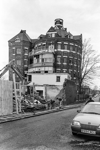
St Giles’ Hospital, Havil Street, Camberwell, Southwark, 1989 89-2c-26
The picture shows the demolition of former workhouse and the start of the conversion to flats of the Grade II listed circular ward tower fronting onto Havil Street. This was built in 1889-90 for the Camberwell Workhouse Infirmary, later St Giles’s Hospital, architect W S Cross. Each fllor contained 24 beds radiating around a central shaft, in which heating and ventilation services were located. I had photographed this building on a walk a few weeks earlier and had gone back to see if work was progressing and I could get a better view.
Plans for the Sceaux Gardens estate in the mature grounds of the former Camberwell House Lunatic Asylum were approved in 1957 and included two 15 storey tower blocks, Lakanal House and Marie Curie House. The estate was named after Sceaux near Paris which Camberwell had twinned with in 1954. I’ve visited Sceaux a few times and it has a rather better palace and park where festivals are held.
The Lakanal fire in 2009 killed 6 and injured at least 20 more; the recommendations from the enquiry were not implemented but would have prevented the later even more disastrous fire at Grenfell Tower. I think this block is probably Lakanal, but can find no details about the statue – and it certainly isn’t Lakanal.
Joseph Lakanal (1762 – 1845) was a French politician, and an original member of the Institut de France and one of the leading administrators of the French Revolution and responsible for educational reforms. He spent some time in the USA and helped to found and became President of what later became Tulane University before returning to France.
Camberwell Church St, Camberwell, Southwark, 1989 89-2d-63
I walked back west along Peckham Road to Camberwell Church St, pausing to take a couple of pictures not online and then this view of houses and a shop on the south side of the street, possibly at 70-72.
Houses, Camberwell Grove, Camberwell, Southwark, 1989 89-2d-65
I was on my way to Camberwell Grove to make photographs in the northern part of the street which I had not visited on my earlier walks. Just a few yards down the street I turned around and took this view looking up towards Camberwell Church St. At left is the path to Chamberlain Cottages mentioned in an earlier walk.
Houses, Camberwell Grove, Camberwell, Southwark, 1989 89-2d-66
A little further down I found this terrace with two porches on houses in the centre. Like most of the buildings along this part of the street this is Grade II listed, described as ‘Early C19 with some later C19 alterations’.
Flats, McNeil Rd, Camberwell Grove, Camberwell, Southwark, 1989 89-2d-52
The flats at left are 125-151 Camberwell Grove and you can see the spire of St Giles Camberwell in the distance. This is the Lettsom Estate, named after John Coakley Lettsom (1744-1815) who lived in Grove House, just beyond the southern end of Camberwell Groce, long demolished. He was Quaker physician and herbalist, who was friends with Benjamin Franklin, Dr. Johnson, Boswell and other leading figures of the day. This land had been a part of Lettsom’s estate.
When the flats were built in the early 1970s their scale was designed to match the nineteenth century housing along this section of Camberwell Grove – although they have four floors rather than the three in most of this. Their brickwork is also of a similar colour but they lack any of the interesting features of the older buildings and are relatively bland.
I made my way through the estate and on to Vestry Gardens where my next post on this walk will begin.
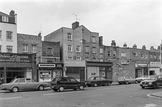
The Dulwich Club, 110a Lordship Lane, East Dulwich, Southwark, 1989 89-2c-55
Lordship Lane is a longish road that goes vaguely south from Goose Green around a mile and a half to the Horniman Museum at Forest Hill, but I only walked a fairly short section at its north end on this walk. Much of the first section was covered by shops in which I found little of interest.
The Dulwich Club, a members only drinking establishment at 110 Lordship Lane was affiliated to the Working Men’s Club and Institute Union, CIU, which was set up in 1862 to promote education and temperance among the working classes, who soon took over what had been a philanthropic middle-class gesture and began also to provide cheap beer as well as other cheap products and services.
Most early clubs were set up as either Liberal or Labour clubs (Conservative Clubs didn’t join, having higher class aspirations) and but the movement as a whole was non-political. This one – as the notice-board shows was assisting its members in council housing to take advantage of the ‘right to buy’ introduced by Thatcher.
If you were a member of any CIU club you could go into any of the other CIU clubs around the country and take advantage of the facilities – particularly the bar.
This building was demolished around 2000 and the site is now housing. The house at left it still there.
Bassano St, Lordship Lane, East Dulwich, Southwark, 1989 89-2c-56
Just a few yards down Bassano Street from Lordship Lane is this religious building, with a cross in the brickwork above the doorway. It was the Epiphany Mission, built in 1908 by architects Nixon, Horsfield & Sons and used as an Anglican church from then until 1927 and then later from 1941-51 as a replacement for St John’s which had been bombed and then as a parish hall until sold in 1994 to finance the Goose Green Centre at St John’s.
My picture is not quite sharp enough to read the name on the notice clearly but I think it says ‘The Epiphany Hall’. At right there is obviously a later extension, perhaps from the 1950s.
The building is now still in religious use as the Church of God (7th Day) Sabbath Keeping Temple.
Lordship Lane Tyres, Lordship Lane, Bawdale Rd, East Dulwich, Southwark, 1989 89-2c-43
One of the more interesting late-Victorian buildings peppered around the area this decorated frontage is at the end of a rather dull terrace with ground floor shops.
I’m unclear as to the intertwined initials at the top of the building , hardly visible in my photograph, but even looking at them more clearly, I’m unsure if they are just D and G or are intended also to include an E.
The shop no longer has the profusion of signs which appealed to me, including two Michelin men, and the billboard higher up has also gone. No longer tyres, the shop is now Franklin’s Farm Shop, a good indication of the extent of gentrification in the area.
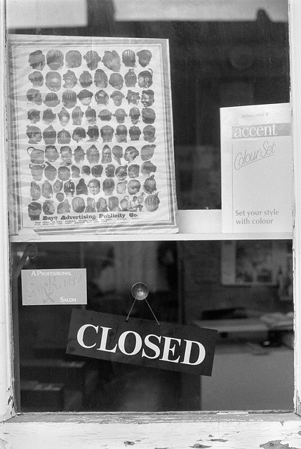
Hairdresser, Window, North Cross Rd, East Dulwich, Southwark, 1989 89-2c-46
North Cross Road, running east from Lordship Lane, had (and still has) a long row of small shops I found of more interest, including this hairdresser’s window with a poster showing various hair styles from a company in Lagos.
Hairdresser, Interior, North Cross Rd, East Dulwich, Southwark, 1989 89-2c-32
The poster could have been on the window of this hairdresser, though there were several to chose between on the street. This is Ena’s and has a poster advertising a Jamaican Easter Shipping Sale.
Hairdresser, North Cross Rd, East Dulwich, Southwark, 1989 89-2c-33
Molly, another hairdresser on the street appears to cater for a more traditional white clientèle. The stained glass window at left with the word SHAMPOOING has a distinctly 1930 feel – and presumably there was once a similar panel on the other side of the doorway. The FOR phone number was for the FORest Hill exchange and went out of date in 1996 when we moved to all figure numbering.
Fresh Fish, Shellfish, North Cross Rd, East Dulwich, Southwark, 1989 89-2c-34
I think this yard with its Fresh Fish and Shellfish stall stored there was at the rear of shops on Lordship Lane, one of which was, from the trays, presumably a bakery. Perhaps the stall was wheeled out for use beside the pub on the corner, a historic pub, The Lord Palmerston built in 1862 (though it has since last ‘The Lord’.)
This was the end of my walk and I got on a bus, but got off my bus to take another picture on Camberwell Road in Walworth.
Rather to my surprise, there was a newsagents in the same shop here until around 2014. The larger house in this picture is now a hotel with a two storey street entrance.
My account of this walk from 5th February 1989 began with http://re-photo.co.uk/?p=14180 A Pub, Ghost Sign, Shops And The Sally Ann. I’ll post shortly about my next walk, a week later.
There is still a doorway here between 56 and 58 Peckham Rye, but the lock above it has gone and it now has a sign for Ezel Court at 56 A and B and 58 A and B. The Antique shop was for some years Delta Tavern, an Arfican Restaurant, then a café called Pedler and most recently a bar and restaurant Good Neighbour. The building building to the right of the doorway is also now a bar.
At top left of my picture who just get a glimpse of the rather finely decorated upper storeys of the two late Victorian buildings at 58 and 60, though for some reason I didn’t bother to cross the road to photograph these.
This window was just a few doors further down at No 64 and I liked the symmetry of its display, though broken by the two identical photographs of a woman looking in the same direction. I don’t think I was at all clear as to what was behind this window – or what the woman in her strongly patterned dress and gloves was meant to represent. And at the centre of the window display is a thick book on a table, a Thesaurus.
The attractive grille above the door is no longer there, and was probably salvaged and sold when the shopfront was updated. In more recent years this has been occupied by an estate agent, a pizza takeaway and beauty salons.
In the reflection you can see the extensive premises of G Austin & Sons Ltd offering secondhand furniture and antiques, now I think replaced by a three-storey block of flats.
I was always happy to photograph people who saw me taking pictures and wanted to have their picture made, though I very seldom took down details so I could give them pictures. So this young man, posing for me in 1989 will not have seen this picture, unless he has visited the page on Flickr only since January 2021 – it has never been published elsewhere.
The Regency Carriage Company has long gone from this site, though the building remains, rather altered. It was for some time an estate agents but has for around ten years been Rye Cars. But the yard in which the cars for sale were neatly aligned is now covered by flats.
St John the Evangelist, East Dulwich Road, East Dulwich, Southwark, 1989 89-2c-66
St John the Evangelist was built in 1865 to the designs of local architect Charles Bailey, but was badly bombed in 1940. Reconstruction began in 1947, incorporating the remaining apse and tower which dominate my picture and was completed in 1951.
House, East Dulwich Road, East Dulwich, Southwark, 1989 89-2c-52
126 East Dulwich Road faces the west end of Goose Green on the corner of Grove Vale and I liked the uncompromising stare of the head above its simple but impressive doorway.
Houses, East Dulwich Road, East Dulwich, Southwark, 1989 89-2c-53
A pair of doorways with heads, with a simiilar design and I think on the same row of houses facing Goose Green as the previous image.
Goose Green School, Grove Vale, East Dulwich, Southwark, 1989 89-2c-54
I walked a few yards north up Grove Vale to photograph this fine Grade II listed example of a school built as Grove Vale School for the School Board for London in 1900 to the Baroque Revival designs of T J Bailey
I turned around here and walked down to Lordship Lane where my next post on this walk will begin.
From Blenheim Grove I turned into Choumert Grove. George Choumert (1746-1831) was a Frenchman from Lorraine, a tanner who married into a wealthy Bermondsey family. When he became a British citizen in 1796 he probably didn’t have to pass a silly exam asking questions that few British people could answer. People could just come and live and work here as foreigners but it isn’t too clear that there was any real way for foreigners to become British back then, though they could become a British subject by a process known as denization, which granted them all the rights of citizens except political rights.
Choumert Grove, Choumert Road and Choumert Square are all named after him. Before his wife’s death he was responsible in 1815-1822 for building part of Rye Lane and Holly Grove, then called George Street. When Choumert’s wealthy wife died in 1825, he inherited her estates which gave him a very healthy income.
The grandly named Choumert Square is a later development, a narrow lane with no vehicular access, infill in the extensive back garden of a house in Rye Lane, but accessed from Choumert Grove. IdealHome ran an interesting piece on one of the small one-bed houses in it in 2018 under the headline Would you be brave enough to buy this London house of horrors for £525,000?
I turned left into Choumert Road to photograph Girdler’s Almshouses, also known as Palyn’s Almshouses. The Grade II listing begins “Row of 5 almshouses. 1852. By Woodthorpe.” The 2018 Trustees Report of the THE WORSHIPFUL COMPANY OF GIRDLERS BEESTON’S, ANDREWES’ AND PALYN’S CHARITY informs us “Palyn’s Almshouses were built in 1980 to replace six almshouses built in 1852 in Montpelier Road, now known as Choumert Road, Peckham, which themselves replaced the original six almshouses founded in 1609 in Pesthouse Row, St Luke’s, Finsbury, as a result of a bequest from George Palyn, Citizen and Girdler.“
Girdlers were makers of belts and girdles and the Worshipful Company of Girdlers were granted the right to regulate trade in these items in the City of London in 1327 – and could seize and destroy any such items that did not meet their craft standards. Palyn was a Master of the guild and his will left money for the Finsbury almshouses.
I walked up Choumert Road to Rye Lane turning south down it. The rather impressive frontage of No 213, previously Bonanza stores was the site of an “EXCITING NEW DEVELOPMENT’ retaining the frontage but with an arcade of 10 shops.
Later it became the London Seafood Superstore and was renamed LOBO House. More recently it has again been redeveloped, along with the fish factory behind.
Co-operative House proudly had its name across the top of the building, along with the dates 1868 and 1932. 1868 was the date when 20 workers at the Royal Arsenal in Woolwich formed the Royal Arsenal Supply Association which a few years later became the Royal Arsenal Co-operative Society with branches across south-east London, including this large store in Peckham, presumably built in 1932, though replacing an older store on the site.
Co-operative societies had stores like this across the whole country, and they played an important part in getting decent products including foodstuffs to working people. We shopped at the Co-op when I was a child and my mother’s six-digit Co-op number which we had to recite at the till is still deeply etched in my memory. Every year we got a ‘divi’ based on the amount we had spent, and I think it paid for us to have a few treats and presents at Christmas which our family could not otherwise have afforded.
There is now a new block here, with ground floor shops and flats above and it carries three large dates, 1862, 1932 and 2008.
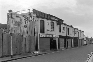
Sternhall Lane is a turning off Peckham Rye opposite the north end of Co-operative House. Timber yards like this were common in 1989, but most like this one have since been redeveloped. About all that is left from this picture is the lamp post. Buying timber now usually means driving to the outskirts rather than finding it in town centres. The wall sign COOPER’S TIMBER AND intrigued me slightly though I think the stacked timber might only be obscuring the letters D.I.Y which are on the boards on the front of the premises. Appropriately this range of buildings appeared to me to have something of a D.I.Y quality.
Nigel Rd also leads off Rye Lane just a few yards to the south of Sternhall Lane. The buildings on the opposite side of Rye Lan in the centre of this picture are still there, but at the left of the row is the end of the Co-op buildings replaced in 2008. The buildings on the corner of Rye Lane at left are still there, but there is no longer a careers office out of picture whose notice is shown here.
The road layout has changed a little and the triangle in the foreground with its keep left signs, one toppled presumably by a driver who failed to obey has gone. It was hard to see what point it had back in 1989, opposite an un-named street leading to a block of council flats, built in the early 1950s.
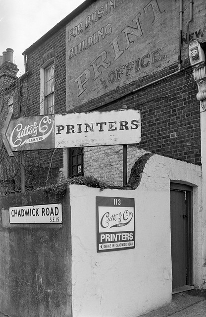
Grove Park changes to Chadwick Road on a bridge across the railway which separates Camberwell from Peckham and continues on, with a considerably less wealthy vibe, one side with long terraces of two-storey two bed working-class houses which now sell for around £900,000.
The north side was more varied, with an industrial estate but nothing attracted my photographic interest until this printers and its multiple signs on the corner with Bellenden Road. The sign on the wall is still there but the rest have gone and the ground floor frontage on Bellenden Road looks very different.
The building is now home to MOCA London, The Museum of Contemporary Art, Londonfounded in 1994 as a project based museum which opened a project space here in the Bellenden Renewal Area in 2004.
Front Garden, Ady’s Rd, East Dulwich, Southwark, 1989 89-2b-33
I turned south down Bellenden Road, made a couple of pictures on Maxtead Road and then went down Oglander Road and into Adys Road where I found this front garden. I couldn’t resist the two donkeys and the gnome in a small car in front of those net curtains. You can see the decorations by the windows of these late Victorian houses which also have fairly impressive rusticated doorways paired together down the street.
Back on Oglander Road a little south of Adys Road was Padwick’s Crash Repairs at the end of a terrace of small houses. Those beyond the garage further down the street are larger and semi-detached. I particularly liked the faces on the two archways and the truncation of both archways, the decorage element at each end of the shopfront suggesting it might have been originally built like this rather than a later addition.
Coach entrances like this were common to many businesses in the days of horse-drawn vehicles – and this certainly predates the era of motor transport. This was once a diary and had large associated buildings in a yard behind. The ‘Old Diary’ was demolished in 2020 and I think is being rebuilt as a new gateway to a mews development behind.
Oglander Rd, Maxted Rd, East Dulwich, Southwark, 1989 89-2b-35
The junction of Oglander Road with Maxtted Road, with Wingfield Street more or less opposite, and shops on the street corners. There is still a shop on the other corner of Oglander Road but this Auto Electrics and the ‘Bottle & Cork’ are now residential.
I went up Maxted Rd to Bellenden Rd where I photographed this chapel on the corner of Danby St. Previously this was Hanover Chapel, but was bought by the Pentecostal Faith Chapel in 1978 in a “grossly dilapidated condition, which took nearly a year to renovate.”
The church was built as a United Methodist Free Church and opened in 1885, eight years after its memorial stones had been laid. It had been planned with a spire which was never built. It was sold in 1920 to Hanover Chapel, the oldest non-conformist worshipping community in Peckham, Congregationalists with a history going back to 1657 when the dispossessed Vicar of St Giles, Camberwell the Rev. John Maynard founded a chapel or meeting House in Meeting House Lane.
Blenheim Grove, Rye Lane, Peckham, Southwark, 1989 89-2b-23
I continue up Bellenden Road to Blenheim Grove, walking down this almost to Rye Lane where I photographed the rather fine building at 133 housing Murrays Meat Market and Ralph Haeems & Co Solicitors. Considerable renovation of this building, the entrance to Copeland Park, took place around 2018-9 and it is now ‘MARKET PECKHAM’, whose developer responded to public pressure to drop plans to turn it into luxury flats.
In earlier years from 1908 to 1915 this was the Electric Theatre – and after I took this picture the first floor became home to The Redeemed Christian Church of God-House of Praise.
Ralph Haeems, Blenheim Grove, Peckham, Southwark, 1989 89-2b-24
I walked back down Blrenheim Grove, and made this picture of another building of Ralph Haeems & Co Solicitors at No 9. This early 19th century villa was Grade II listed in 1998 and was acquired by Southwark Council for use as offices in 2002. They ceased to use it in 2010 after the council acquired its new offices in Tooley St in 2007 and the council decided to sell it in 2011.
The building is now two residential properties, 9 and 91/2 Blenheim Grove.
My account of the walk in Peckham in 1989 will continue in a later post.