Ravensbourne Walk – 2012

Ravensbourne Walk: On Sunday 13th May 2012 I decided to take a walk alongside one of London’s rivers, the Ravensbourne. It isn’t one of London’s best-known rivers and perhaps lacks the glamour of the so-called ‘lost rivers’.

The Ravensbourne still flows largely above ground, and its final tidal section before it enters into the Thames is the rather better-known Deptford Creek, once an important industrial area. It also once powered a number of mills along its length.

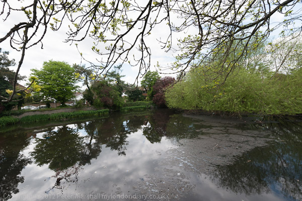
I’d decided not to begin at its source at Caesar’s Well in Keston but to join it around 4 miles to the north at Bromley where I could join it by a short downhill walk from Bromley South station. The area around Bromley has several culverted sections of the river and it emerges from one of these into a lake at the west of Church House Gardens, disappearing again for a short section before coming into the open in parkland in Martins Hill Open Space north of Glassmill Lane.

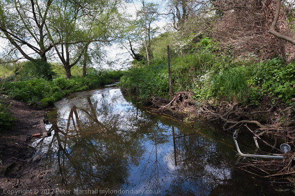
It then goes underground for around a quarter of a mile before appearing again along the edge of a golf course, but non-members have to walk along Ravensbourne Avenue before seeing it again at the bridge under Farnaby Road.

From there on the river flows in the open through Beckenham Place Park and I could walk beside it or close to it, having to weave my way through various roads in an estate here. Just to the east of the river on Brangbourne Road is a large council estate with blocks named after various rivers, mostly I think London Rivers, and a block on the corner with Old Bromley Road is Ravensbourne.

After a small green area on the corner of Bromley Rd and Beckenham Hill Rd which it then goes under to feed a large pond at Homebase. The map I was using for the walk shows this as a stream with a weir in the middle. Part was once the mill pond for Lower Mill, a corn mill (which was at different times a mustard mill and a cutlery mill) on the corner of Southend Lane. Upper Mill stood roughly here on the corner of Beckenham Hill Rd.

Overlooking the pond at Hoomebase I photographed the sculpture The Whisper, Andre Wallace 1984 and the church hall opposite. The river leaves the pound overground, emerging into the open again a couple of hundred yards on as it goes under Watermead Lane where it runs between houses and flats. You can follow this on a back-street but I took the more interesting route along the Bromley Road.

Allerford Rd

At Randlesdown Road it flows into the Catford Trading Estate, then goes under Fordmill Rd just north of the railway bridge. Shortly after here it joins what is usually called its largest tributary, the River Pool, though I think this is usually a larger river than the Ravensbourne, though shorter before continuing under Catford Road next to Catford Bridge Station.

It was a hot day, and I had done rather more walking around than the relatively short route taken by the river, and I was tired. I had intended to walk on to Lewisham or perhaps even Deptford, but abandoned my plans and caught a train here.

More pictures on My London Diary at Ravensbourne.


FlickrFacebookMy London DiaryHull PhotosLea ValleyParis
London’s Industrial HeritageLondon Photos

All photographs on this page are copyright © Peter Marshall.
Contact me to buy prints or licence to reproduce.


Greenwich and Deptford Creek October 1988

Caesars American Restaurant, Waterloo Rd, Lambeth, 1988 88-10e-55-Edit_2400
Caesars American Restaurant, Waterloo Rd, Lambeth, 1988 88-10e-55

I had spent several days wandering around Hackney in the previous months and decided it was time to go back south of the river and picked on Deptford for my next walk. I’d decided to get a train from Waterloo East to Greenwich as my starting point, but arrived in to Waterloo with some time to spare and walked briefly along Waterloo Road. You won’t find Caesars there now, its place taken by a vape shop and Tesco Express.

Norman Rd, Greenwich, 1988 88-10e-56-Edit_2400
Norman Rd, Greenwich, 1988 88-10e-56

I took the train to Greenwich Station and came out onto Norman Road which is on the east side of Deptford Creek. There are still some industrial sites here but the area to the north shown in my photograph now has tall blocks of flats both on the creek side (to the left of my picture) and on the right. There was no access to the Creek here.

Posters, Norman Rd, Greenwich, 1988 88-10e-41-Edit_2400
Posters, Norman Rd, Greenwich, 1988 88-10e-41

The area around Deptford Creek now has many artists studios, but back in 1988 I wasn’t expecting to see this kind of display in the area, and it wasn’t at all clear whether this was a result of fly-posting followed by vandalism or art, though I inclined to the latter. It certainly had become art by the time I photographed it.

Deptford Creek, Creek Rd, Deptford, Greenwich, 1988 88-10e-44-Edit_2400
Deptford Creek, Creek Rd, Deptford, Greenwich, 1988 88-10e-44

Finally on Creek Road I was able to see the creek itself, looking across to Deptford from the Greenwich end of the bridge. In the distance is the spire of St Paul’s Deptford. Tall blocks built around 2017 on Copperas Street now block that view.

Deptford Creek, Creek Rd, Deptford, Greenwich, 1988 88-10e-45-Edit_2400
Deptford Creek, Creek Rd, Deptford, Greenwich, 1988 88-10e-45

Walking across the bridge gave me this view of the Deptford side. Creek Road Bridge is a lifting bridge and in 1988 often caused severe traffic delays in the area when lifted at high tides to allow vessels to pass. I think bridge lifts are now rare, though at least until recent years they were still occasionally needed to allow vessels carrying aggregate to berth at Brewery Wharf just below the bridge on the Greenwich side.

In the distance you can see the Deptford Creek Railway Bridge which was also a lifting bridge, though of very different design. I understand this is now welded in place and incapable of lifting.

Deptford Creek, Creek Rd, Deptford, Greenwich, 1988 88-10e-46-Edit_2400
Deptford Creek, Creek Rd, Deptford, Greenwich, 1988 88-10e-46

Although Deptford Creek forms the boundary between Deptford (in the London Borough of Lewisham) and Greenwich for much of its length, the area around its mouth from a little south of Creek Road as far west as Watergate Street in Deptford is in the London Borough of Greenwich, including the whole now former site of Deptford Power Station. Both sides of the Creek were industrial in 1988, though the last of the three power stations had ceased operation in 1983, and it was spectacularly demolished in 1992. The first station, designed by Sebastian de Ferranti and opened in 1889 was the world’s first ‘central’ power station, operating at high voltage and on an unprecedented scale and closed in the 1960s.

Deptford Creek, Creek Rd, Deptford, Greenwich, 1988 88-10e-32-Edit_2400
Deptford Creek, Creek Rd, Deptford, Greenwich, 1988 88-10e-32

Much of the Deptford side of the Creek north of Creek Road was occupied by scrap metal dealers and in 1988 this brick building at Crown Wharf was the offices of London Iron & Steel Limited.

Deptford Creek, Creek Rd, Deptford, Greenwich, 1988 88-10e-33-Edit_2400
Deptford Creek, Creek Rd, Deptford, Greenwich, 1988 88-10e-33

The Creek turns west after going under Creek Road, then around to the north to enter the RIver Thames. There is a large pile of scrap on the wharf in front of the disused power station and Turbulence, a general cargo vessel, 1426 tons gross built in Selby, Yorkshire in 1983 is moored there. Large heaps of sand and gravel are at an aggregate works on the Greenwich bank, though previously there had been a gas works here.

Today the scene is entirely different, with large residential developments on both sides of the Creek, at Millennium Quay on the west and New Capital Quay on the east. A new footbridge joining the two across the mouth of the Creek was opened in 2015. This is a swing bridge which also occasionally has to be opened to let vessels pass at high tide.

My walk continues in a later post.