Hull Colour 2

A look at a few more of my colour pictures from Hull in the 1970s.

Paint, Hull 70shull077
Paint, Hull 1970s

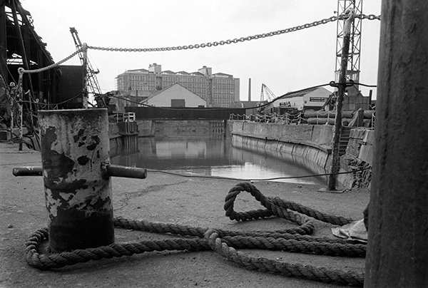
I made a number of exposures of this wall, which I think was possibly at one of the dry docks on Dock Office Row, though my memory may be at fault. I often walked up High St from Clarence St next to Drypool Bridge and then on to Wincolmlee, sometimes continuing on up to Bankside or Air St, where I could walk west and across towards my parents-in-law’s house just off Chanterlands Ave north.

I was attracted by the colour but also by the mix of the accidental and deliberate in the markings on the wall. Like quite of few of the other images, time has added its mark to this picture, with some patches of blue which I haven’t entirely managed to retouch where mould has attacked the dyes.

Hull 70shull083
Hull 1970s – a distant view of Saltend

I can’t recall at all taking this picture, and another also taken from a similarly rural viewpoint with the chemical works in the distance. From the view I think it is taken from somewhere on the west edge of Hedon, perhaps on a walk from Hull to Paull.

But when or wherever it was made, its an image I like for its contrast, both visually and between the agricultural and industrial.

Weighton Lock, Broomfleet, 72-80-Hull-005
Weighton Lock, Broomfleet, 1970s

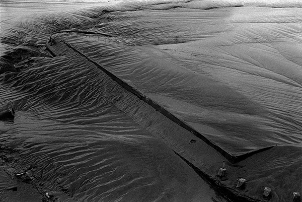
In contrast I remember our family walk which took us to Weighton Lock well. If you have travelled my rail from Selby or Doncaster to Hull, your train will have sped through Broomfleet, and you may just have seen a station there.

The man in the ticket office at Hull Paragon station seemed surprised when we asked for tickets to Broomfleet, but trains do stop there. Now you have a choice of the 07:19 or the 16:21 – but then there were rather more though I think we did have to tell the guard we wanted to stop there – and to hold our our hands for the returning train.

The lock is where the Market Weighton Canal joins the River Humber. Opened in 1782, the canal was both a navigable waterway and a drainage ditch. The upper section was closed around 1900 and the lower few miles to the lock abandoned in 1971. The Market Weighton Civic Trust managed to save the lock by getting it listed as an ancient monument, and it was repaired and reopened although there is no right to navigation around six of its original nine and a half miles remain navigable.

A few other pictures in the album are also from trips we made from Hull, including to Flamborough.

Guildhall Rd, Hull 72-80-Hull-008
Guildhall Rd, Hull, 1970s

Until ‘The Dock’ was opened in 1778, ships coming to Hull moored the the ‘Old Harbour’ in the River Hull, where staithes still run from the High St to the river. The dock was the largest dock in the UK when it was built, and soon became known as the ‘Old Dock’, but was renamed Queen’s Dock in honour of the visit to Hull by Queen Victoria and Prince Albert in 1854.

By the 1920s it was redundant, with docks on the Humber – Victoria Dock, Albert Dock, Alexandra Dock, Riverside Quay and King George Dock – forming the port of Hull, and it finally closed in 1930. The city bought it and filled it in to create Queen’s Gardens. Filling it took four years – one year longer than its construction and provided some employment during a period of recession.

I’m not sure exactly where these former warehouses on the south side of Queens Dock (Queens Gardens) in Guildhall Road were, but from the street sign I think they were just to the west of Quay St and have since been demolished.

River Hull, Hull 72-80-Hull-011
River Hull, Hull from North Bridge

I added the following text to a black and white image on my Hull photos web site taken from just a foot or two to the left of this image:

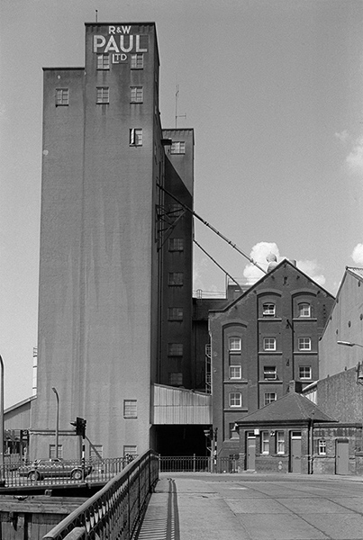
Peeling paint on a wall advertises the coal and sand wharf belonging to ‘Henry’, which I think may be Henry Mead & Co at 15 Lime Street, which was wound up in 1973. On the west bank of the Hull are a long line of wharves and buildings on Wincolmlee, with the towering silos of R&W Paul (now Maizecor) in the distance. A single vessel is visible moored at one of the Lime St wharves.
 
Floods from the Hull, mainly because of a tides coming up from the Humber, were fairly frequent before the tidal barrier was built, because the corporation failed to get wharf owners to maintain adequate flood defences. A number of derelict properties made their job more difficult. More recent floods have been because of excessive rainfall in the Hull valley.

Apart from the Maizecor silo, none of the buildings visible in this slide are still standing.

Hull colour

Humber Dock Basin, Hull 70shull052
Silted up dock. 1970s

I’m aware that its a while – over a year since I’ve written anything here about Hull, so here is the first of a short series of posts about a city where I’ve spent quite a lot of time photographing.

King Billy, Hull 70shull048
King Billy, 1970s

I’ve never actually lived in Hull, but for around 35 years I visited the city regularly visiting my wife’s family home, where we stayed for at least a week every year, more in the earlier years. After that house was sold we had a good friend who was always pleased for us to stay with him in his large mansion, but since his death around ten years ago my visits have been less frequent.

Window, Hull 70shull069
Old Town reflection, 1970s

During those visits to Hull I spent a lot of time on the streets taking photographs, sometimes out with other family members, but often on my own.

Docks notice, Hull 70shull070
Docks Notice, 1970s

Mostly I was photographing in black and white, working on a project that in the early 1980s became an exhibition (and much later a book) ‘Still Occupied – A View of Hull’. As well over a hundred black and white images, the show at the Ferens Gallery also included around 40 colour pictures, giving a more abstract view and concentrating on the docks and the River Hull and the riverside industries.

Poulterers, Hull 70s-hull073
D Marks & Sons. Possibly on Humber St, 1970s

At that time I worked in colour using 35mm transparency film and quite a few of the slides have either been discarded or deteriorated beyond recovery, while others have been lost. But a couple of months ago I found around 250 of the more interesting pictures and re-photographed them using a Nikon D810 fitted with a Nikon PB-6 bellows, Nikon 60mm f2.8 macro lens and PS-6 slide duplicating attachment.

Window, Hull 70shull075
Dockside Shed, 1970s

The pictures here come from the first fifteen in the album, and the top one, which I think is probably of Railway Dock, shows the silted up state of the disused docks at that time. Those familiar with Hull will recognise ‘King Billy’ below this, reflected in the window of the pub where he is reputed to drink when the clock strikes thirteen. It’s a little harder to recognise the buildings reflected in the window below, particularly because the double image makes it seem more slender – or to read the rather minimal remains of the dockside notice that follows.

I can’t remember exactly where D Marks and Sons had their poulterers business, perhaps has the caption suggests on Humber St, but it could have been somewhere off the Hessle Rd. The distinctive blue shed was one of several around Humber Dock Basin.

Dockside shed, Hull 70shull046

All photographs on this and my other sites, unless otherwise stated, are taken by and copyright of Peter Marshall, and are available for reproduction or can be bought as prints.


A River Full of Stories

I’m pleased to have some of my pictures included in ‘A River Full of Stories‘ , a large hardback of around 200 pages recently published by Rich & Lou Duffy Howard in Hull. It’s an unusual title in several ways, and comes from their online project of the same name, a follow-up to their Open Bridges (which I wrote about here) which was a part of Hull’s 2017 year as UK City of Culture.

The book launch took place a little over a week ago, though I’m sorry I was unable to attend as I was at a weekend meeting elsewhere.

I have a small portfolio with 6 pages of my work, all reproduced well and to a good size on the roughly 10×11″ pages, as well as three other large reproductions in the main body of the book.

The book is packed with interesting photography, both historical and contemporary of Hull and its river, and the presentation is one only made possible by considerable sponsorship attracted to the project acheived by Rich and Lou Duffy-Howard who curated and edited it both online and in print.

You can of course read about it in the Hull Daily Mail (though I don’t get a mention) and there is an exhibition about both projects in the centre of Hull at the Hull Maritime Museum in Queen Victoria Square until the end of 2019.

The book is unusual in that it is not for sale, but contributors were given a free copy along with every library in Hull and the East Riding. However you can still buy the Café Royal Book  The River Hull 1977–85 which has most of the pictures in it – if on a rather smaller scale and less expensively reproduced. My other Café Royal Book on Hull, The Streets of Hull 1979–85 is also still available. And you can see many more pictures on my Hull web site in the links below.


There are no adverts on this site and it receives no sponsorship, and I like to keep it that way. But it does take a considerable amount of my time and thought, and if you enjoy reading it, please share on social media.
And small donations via Paypal – perhaps the cost of a beer – would be appreciated.

All photographs on this and my other sites, unless otherwise stated, are taken by and copyright of Peter Marshall, and are available for reproduction or can be bought as prints.