Posts Tagged ‘Canning Town’

Saw Mills & Flood Barrier

Tuesday, February 16th, 2021

M & J Reuben, London Sawmills, Wharfside Rd, Newham, 1983 35t-25_2400

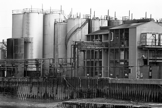
Standing more or less on the bank of Bow Creek beside the saw mill in 1983 I could see the elevated East India Dock Rd from which quite a few of my pictures were taken, and beyond it the box-like West Ham Power Station with its two pencil-like chimneys and cooling towers. Sawing timber creates a great deal of dust and a large extractor removes this, probably more for its commercial value than an anti-pollution measure.

Bow Creek, Flood Barrier, Saw Mill, Wharfside Rd, Newham, 1983 36v-25_2400

Looking down from East India Dock Rd onto the circular car park where Wharfedale Rd emerged from the tunnel under the road. There were few if any traces of the old railway line that used to run between the fence and the river here – where the DLR now runs. The picture gives a good impression of the densely packed industry on the peninsula beyond the creek. Taken with an extreme wide-angle lens – the 21mm on the Olympus OM1 you can see some stretching of objects closer to the edges of the frame which is a consequence of rectilinear perspective.

Bow Creek,  Flood Barrier, Wharfside Rd, Newham, 1983 35t-11_2400

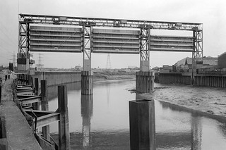
Working from more or less the same position (but on a different day) with a less wide lens (probably a 35mm) gives a considerably less wide view, making distant objects seem larger, and also avoids any noticeable distortion. You can see the flood barrier on Bow Creek much more clearly.

Canning Town, Flood Barrier, Bow Creek, East India Dock Rd, Newham, 1982 36v-26_2400

Moving a little further along East India Dock Road gave a better view of the river now running south through the flood barrier. At left are the tower blocks of Canning Town. The row of buildings at right are on the far side of Victoria Road, and the railway line from Stratford to North Woolwich is in front of them, hidden by a bank of earth. Stairs led down from the road to this waste land and there were no fences to stop me walking along the river bank.

Flood Barrier, Bow Creek, Newham, Tower Hamlets, 1983 36a-32_2400

From the bank I got a good view of the flood barrier, its three gates in raised position, getting shorter from left to right to match the slope of the creek, deeper on the outside of the curve. Building the Thames Barrier at Charlton which first came into operation at more or less at the time I made this picture made this barrier, previously essential to prevent flooding along Bow Creek, redundant. It was removed shortly after I made these pictures.

Flood Barrier, Bow Creek, Newham, Tower Hamlets, 1983 36a-36_2400

Back in 1983 there were no barriers to stop me walking beside Bow Creek all the way to the River Thames, but not long afterwards this whole bank was closed off to the public. There have long been plans to open part of it as a riverside walkway, with the northern part of it built but fenced off, and in 2004 following a public competition a winning design was selected for a bridge further downstream a little below the Lower Lea Crossing across the river as a part of this foot and cycle path to Trinity Buoy Wharf. But in 2005 the Thames Gateway Delivery Unit withdrew funding and the bridge was never built. The last time I visited the area a couple of years ago the riverside walkway was open but ended around a hundred yards south of Canning Town station.

Flood Barrier, Bow Creek, Newham, Tower Hamlets, 1983 36a-23_2400

There is now a bridge across close to Canning Town station leading to the development of City Island which has replaced the edible oil factory on the peninsula which opened in 2014, though a far less interesting design than the competition winner.

The empty area to the east of Bow Creek which can be seen in some of these pictures was from 1837 to 1912 the home of the Thames Ironworks and Shipbuilding Company Ltd. More recently it was for some years given over to a construction works yard for Cross Rail and is now home to the Limmo Peninsula, a largely residential development scheme by a partnership between TfL and Grainger plc.

You can visit my Flickr album with more pictures of the area by clicking on any of the pictures above which will take you to a larger version from where you can explore the album. Future posts will look at a series of panoramic pictures I made in 1992 and continuing my walk to the Thames.


All photographs on this and my other sites, unless otherwise stated, are taken by and copyright of Peter Marshall, and are available for reproduction or can be bought as prints.


Bow Creek: Priors to Pura Foods

Monday, February 15th, 2021

Bow Creek, Leamouth Rd, Leamouth, Tower Hamlets, Newham, 1982 36v-23_2400

Goiong down Leamouth Road roughly south and parallel to the river there were a few places where you could look back up to the East India Dock Road and the disused railway bridge that crossed the creek a little to the south of the road. The bridge had carried a line which came from where Canning Town Station now is along the route now followed by the DLR but continuing across the river to pepper warehouses for the East India Docks opposite the docks on the eastern side of Leamouth Road, still shown on my 1939 Philip’s A B C Pocket Atlas-Guide to London and its Outer Districts.

J J Prior, Ship Repairs, Orchard Wharf, Bow Creek, Leamouth Rd, Leamouth, Tower Hamlets, 1982 36v-36 (2)_2400

Where the river swung around the Limmo Peninsula – now the Bow Creek Ecology Park – the view was wide open with the river only separated from the road by an open fence. Close to the bend to the west was Orchard Wharf, where J J Prior were still carrying out ship repairs. The flats in the background are on the other side of the East India Dock Road.

Pura Foors, Bow Creek, Tower Hamlets, 1983 36v-21_2400

Looking up the creek on the eastern side of the peninisula was the west bank of the second peninsula, occupied by a large edible oil factory, Pura Foods, the smells from which were often rather noticeable. There were local campaigns to have this factory shut down, and eventually it did move out, relocating a few miles down-river. This peninsula is now redeveloped as City Island.

Pura Foods, Orchard Place, Leamouth, Tower Hamlets, 1982 32f-33_2400

Roads in this area were disrupted when the Lower Lea Crossing was built – it opened in 1991. When I first went to photograph the area, Leamouth Road (historically called Orchard St) continued to meet Orchard Place at a T-junction, with Orchard Place going north to the Pura Food site and south, then turning east to Trinity Buoy Wharf.

Pura Foods, Bow Creek, Tower Hamlets, 1989 89-4c52_2400

Although there were still high walls along the northern section of Leamouth Rd, there was a clear view of Bow Creek looking south from the East India Dock Road only around a hundred yards east of where the river, here flowing roughly north, went under the bridge in the opposite direction.

Bow Creek, Pura Foods, Essex Wharf, Wharfside Rd, East India Dock Rd, Newham, Tower Hamlets, 1989 89-4b12_2400

Wharfside Road comes in a short tunnel under the East India Dock Road on which I was standing to take this picture, leading to Essex Wharf and the saw mills for the timber yard. The Docklands Light Railway now runs along here on the route of the the former rail line to the pepper warehouses, just in front of the line of parked cars in this picture.

There is now a footbridge across the DLR leading to a riverside path, built at around the same time as the new railway, the gates to the bridge were kept locked for most of its first twenty years but now seem to be permanently opened, and it provides a good short cut to Canning Town Station, whose riverside entrance was also locked for years after it was built, as well as to a new footbridge to City Island which replaced the factory here. You can also now walk or cycle down here to the right to visit the Bow Creek Ecology Park. Although very different it is still an interesting area in which to walk.

Clicking on any of the above images will take you to larger versions in my Flickr album on the River Lea. A further post will start at Wharfside Road and look at my pictures moving along Bow Creek towards the Thames.


All photographs on this and my other sites, unless otherwise stated, are taken by and copyright of Peter Marshall, and are available for reproduction or can be bought as prints.