Gunnersbury Park & Brentford – 2018

Gunnersbury Park & Brentford - 2018
Gunnersbury House Museum – the ‘Large Mansion‘

Gunnersbury Park & Brentford: Another family outing on Friday 24th August 2018 took us to Gunnersbury House Museum, a free museum jointly owned by the London Borough of Hounslow and the London Borough of Ealing. It turned out to be considerably more interesting than I expected.

Gunnersbury Park & Brentford - 2018
Lionel Road – now the site of Brentford Community Stadium

The 200 acre Gunnersbury estate was bought in 1925 from the Rothschild family by Ealing Borough Council and Acton Borough Council for £130,000, although it was all actually just outside their areas and in Brentford Urban District. They wanted to build over it, but the Rothschilds stipulated that all except a small part of it it was only to be used for leisure and recreation and it was opened to the public as a park by Neville Chamberlainn, then Minister of Health, in 1926.

Gunnersbury Park & Brentford - 2018
The elevated section of the M4 above the Great West Rd

Development of the site as a ‘country estate’ on the outskirts of London had begun in the late 17th century when the first large mansion, Gunnersbury House was built around 1663. The estate passed through various hands including wealthy merchant and MP Henry Furnese who had noted landscape designer William Kent give the park a makeover. Next Princess Amelia, favourite daughter of George II, had further changes made to the grounds for her famous parties there, including building a bathhouse.

Gunnersbury Park & Brentford - 2018
The temple is the only 18th century building remaining on site

The first mansion was demolished in 1801 and the estate was split into two adjoining estates each with a new mansion.

Gunnersbury Park & Brentford - 2018
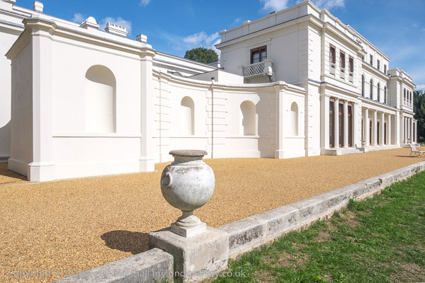
A long series of rooms faces the garden in the ‘Large mansion’

The Grade II* listing for the ‘Large Mansion’ states it was built in “1801-28 by and for Alexander Copland; remodelled 1836 by Sydney Smirke for Nathan Mayer Rothschild, the City financier and Frankfurt-born founder of the British branch of this famous international Jewish banking dynasty.”

Gunnersbury Park & Brentford - 2018
The ‘Small Mansion’ still in rather poor condition

Next door the “Small Mansion”, on the site of the former mansion was built in 1801-1802 for Stephen Cosser according its Grade II listing, though other sources place it a few years later. It was extended with a service wing in 1837-44 by eccentric “Rogue Gothic” architect Joseph Peacock (1821–1893).
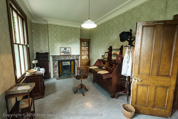
The Rothschilds had two French chefs who shared this office

The Rothschilds bought the Large Mansion (now the museum) and its gardens and park in 1835, adding the Small Mansion and its grounds in 1889 to recreate the now Grade II* listed Gunnersbury Park.

Large prints from Leopold de Rothschild’s Autochromes show the place as it was over a hundred years ago – with flamingos

I walked with Linda to the park from Kew Bridge Station along Lionel Road “with some difficulty as it is now a building site and crossed the Great West Road under the overhead M4, a Ballardian trek past the old and closed castellated gate to the park to enter into a sylvan wilderness, walking past the Potomac lake and its gothic folly.”

The garden slopes down from the house to a lake

Older members of our party took a shorter walk from the underground at Acton Central. Lionel Road is now overlooked by Brentford Community Stadium opened in 2020.
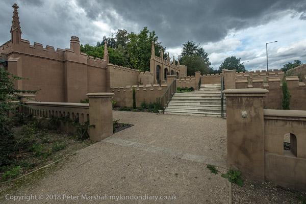
Princess Amelia’s Bath House

The park is certainly worth a visit and on My London Diary you can read more about what were for me the two highlights.These were the huge Rothschild’s kitchens where meals, not generally kosher, were prepared under the supervision of two French chefs, and a display of large prints from the Autochromes taken by Leopold de Rothschild using the first practical colour photography process patented by the Lumiere brothers in 1903 and sold to the public from 1907.
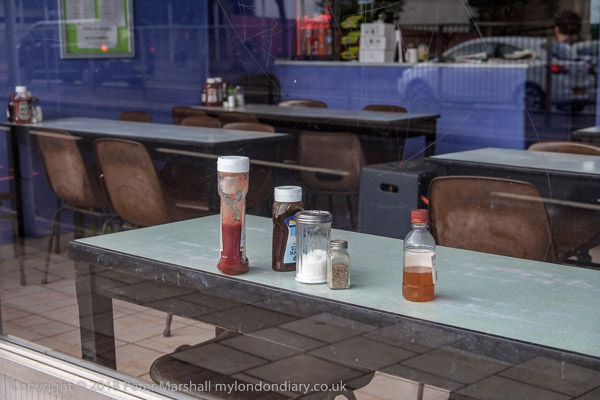
I made a new picture as we passed a cafe I photographed almost 30 years earlier on our way to Kew Bridge

We ate, not from those kitchens but from the modern park café, “tasty but rather insubstantial, and if you visit and are hungry, I’d advise a side order of chips” – or a short walk to a cheaper place near Acton Town station.
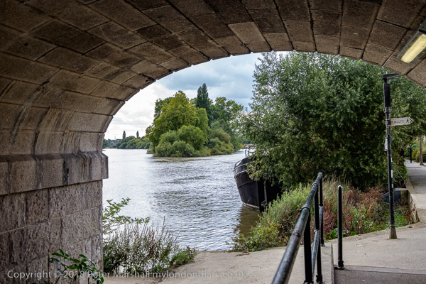
The Thames and Brentford Ait from under Kew Bridge

After the meal we said goodbye to the others and took a longer walk around the park before walking back to Kew Bridge station. With almost half and hour to wait for the next train we took a short walk by the River Thames to Brentford High Street and back.
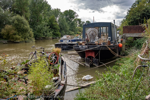
Mooring on The Hollows

You can read more about our trip to the park and the museum and see many more pictures from the day on My London Diary at Gunnersbury Park & Brentford.


Flickr – Facebook – My London Diary – Hull Photos – Lea Valley – Paris
London’s Industrial Heritage – London Photos

All photographs on this page are copyright © Peter Marshall.
Contact me to buy prints or licence to reproduce.


River Thames, St Mary’s, Church Rd, Chelsea Harbour & A Bridge

River Thames, St Mary’s, Church Rd, Chelsea Harbour & A Bridge continues my walk on Friday 4th August 1989 in Battersea from the previous post, Battersea Park, Flour Mill and Somerset Estate. The walk began with Council flats, Piles of Bricks, A House Hospital and Brasserie.

House boats, Mooring, River Thames, Chelsea Wharf, Kensington & Chelsea, Battersea Church Rd, Battersea, Wandsworth, 1989 89-8b-35

The churchyard of St Mary’s Church is on the riverside and back in 1989 was the first place I could access the river in Battersea upstream of Battersea Bridge. The churchyard was closed for public burials in 1854.

The moorings here look rather crowded. At Spring Tides the river comes into the churchyard at high tide and I think people living on the houseboats here would need wellingtons, but the tide was low when I made this picture. On the west side of the churchyard is a slipway and past that was Church Wharf, part of Battersea Wharf. Immediately on the corner of the slipway until fairly recently was the Old Swan pub. Once a solid Victorian building it had been replaced in the 1960s by a strange building with much wooden planking and large windows which had become a punk venue in the 70s before closing, being squatted, and becoming derelict and then perhaps conveniently burning down. The block of expensive riverside flats which replaced the pub is named Old Swan Wharf.

St Mary's, Church, Battersea Church Rd, Battersea, Wandsworth, 1989 89-8b-21
St Mary’s, Church, Battersea Church Rd, Battersea, Wandsworth, 1989 89-8b-21

St Mary’s Church is a real gem, Grade I listed, built in 1775-77, architect Joseph Discon, though the painted glass in its East Window is said to date from 1631, attributed to Bernard van Linge and transferred from the previous church building on this site. The stonework around this window is even older, dating from 1379 when the church was owned by Westminster Abbey and they sent one of their masons over for the job.

Bomb damage in the 1940s gave the then vicar the chance to smash some of the “very bad Victorian stained glass” which made the interior gloomy and there are now four modern stained glass windows. One commemorates William Blake who was married here in 1842 and another J M W Turner who was rowed across from his Chelsea house each day and sat at the vestry window to paint his riverscapes. The famous 18th century botanist William Curtis is commemorated in the third, while the fourth is for the US “archetypal traitor” General Benedict Arnold, given by an American donor.

Houses, Battersea Church Rd, Battersea, Wandsworth, 1989 89-8b-24

At the extreme right of this picture is a sign pointing to the riverside walk which began next to the slipway beside the church and in the centre is the rather ugly riverside development of Valiant House, in 1971 one of the earlier blocks of luxury riverside flats. The Survey of London quotes it being described as ‘luxurious and dismal, a high security complex which afforded views of the river as well as the rubbish tips on Chelsea
Reach
’. It took its name from the former concrete works on part of the site at Valiant Wharf, and perhaps the only mitigating grace of the development was that it provided a narrow riverside walkway, though a little narrow.

The houses at left, probably mainly Victorian with various alterations now look rather different but the facades along the street remain.

Houses, Battersea Church Rd, Battersea, Wandsworth, 1989 89-8b-25

A few yards along the street with an attractive curve leading to Battersea Square the view here seems little changed now. You can see the Grade II listed Raven (no longer a Pub) just to the left of the traffic light.

Lamp post, River Thames, Chelsea Wharf,  Kensington & Chelsea, Vicarage Walk, battersea, Wandsworth, 1989 89-8b-13
Lamp post, River Thames, Chelsea Wharf, Kensington & Chelsea, Vicarage Walk, Battersea, Wandsworth, 1989 89-8b-13

The view across the river to Chelsea Harbour. Planning permission was granted for this huge riverside development in 1986 and building proceeded rapidly. By 1989 from across the river it seemed complete and very different to what Sands End would have looked like when Nell Gwyn lived here or when it was a coal dock for the gas works and railways. The old coal dock, became a somewhat shorter marina. The 18 storey tower was erected at a rapid pace, with at one point gaining a new floor every 4 days, and was topped out in six months.

The 310 luxury flats in the new development were marketed with prices starting at around £2 million per property and have 24 hour security patrols and porterage.

Being towed by a tug upriver are empty containers which have carried London’s rubbish away downstream and are now returning upstream to the refuse depot at Wandsworth for refilling with the barge sitting considerably higher in the water. I think this general waste now mainly goes for incineration at Crossness.

Moorings, River Thames, Railway Bridge, Albion Quay, Lombard Rd, Battersea, Wandsworth, 1989 89-8b-16

Battersea Railway Bridge was built in 1863 and has been strengthened and refurbished in 1969 and in 1992 after I made this picture.

It provides one of relatively few links between railways south of the Thames and those to the north and is used by Overground and mainline trains running between Kensington Olympia (and points north) and Clapham Junction. It is also used by goods traffic which could use Battersea’s extensive rail network to run almost anywhere in the South.

The stretch of walkway by the river leading here through the narrow Vicarage Gardens next to Vicarage Crescent had been opened up some years earlier. But there was still little access to the river beyond the railway bridge. Since then the riverside path now continues through one of the railway arches.

There are plans for a foot and cycle bridge across the Thames next to the railway bridge, but although a start has been made on this project and planning permission was given by both Wandsworth and Hammersmith & Fulham in 2013 I think funding remains a problem; but Wikipedia states ‘The forecast opening date is 2025, taking 18 months to build and audit.’

More on my walk in August 1989 in a later post.


Flickr – Facebook – My London Diary – Hull Photos – Lea Valley – Paris
London’s Industrial Heritage – London Photos

All photographs on this page are copyright © Peter Marshall.
Contact me to buy prints or licence to reproduce.