Crag Fell – Ennerdale – 2018

Crag Fell – Ennerdale: In 2018 we spent a week with friends in a cottage at Ennerdale Bridge on the western edge of England’s Lake District. You can read more about this holiday and some of the other things we did on the September 2018 page of My London Diary, but this post is about our last full day, Thursday 6th September 2018, when we decided we would walk up the fell which overlooked the cottage where we were staying, Grike.

Crag Fell - Ennerdale
Ennerdale Water from somewhere near the top of Crag Fell

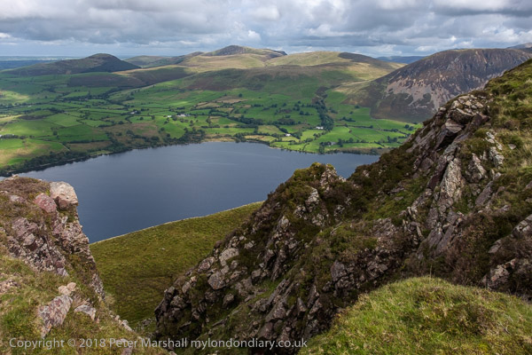
Ennerdale Water is the most westerly lake in the Lake District National Park and is probably the least visited, despite its great beauty. It is the most remote of the lakes and there is no public road up Ennerdale Valley, though it is on Wainright’s Coast-to-Coast walk which became an official National Trail in 2012. Britain’s most remote Youth Hostel is in the valley, YHA Black Sail, only accessible on bicycle or on foot – though it does have a car park 6 miles away.

Crag Fell - Ennerdale

In 2018 when we were there, Ennerdale was still a reservoir for drinking water for customers in West Cumbria, but that ended in 2022. The lake is surrounded by some of the best-known fells in Cumbria which go up to around 900 metres, almost 800 metres above the lake and valley floor.

Crag Fell - Ennerdale

Our walk was a little less ambitious, climbing up to Crag Fell (523m and 522m) and then on to Grike, a little lower at 488m. Mostly it was fairly easy walking though rather definitely uphill in parts, stressing muscles I normally use little, living on the flat plain of south-west Middlesex.

Crag Fell - Ennerdale

Our path took us up beside a small stream, Ben Gill and then through rough grass up to the summit. Altogether we had to climb around 420m to climb, though of course there were times when the path went down a little just to give us more work to do. As I noted in 2018, calling it 1400 feet sounds more impressive.

Crag Fell - Ennerdale

As we got higher I needed to stop more and more and my camera gave me a good excuse, so I took a great many photographs on this part of the walk. But the view does change, sometimes dramatically, and at times I was well ahead of the other six and a dog.

From the twin summits of Crag Fell and from Grike where ee stopped to eat our sandwiches in the shelter of a large cairn we could see to the head of the valley and also to the windfarms on the coast and in the Solway Firth and beyond them the coast of Scotland and the distant hills.

From our path down from Grike we also got a view of Cumbria’s most notorious site, Sellafield, over a ridge in the distance. It is a major employer in the area but perhaps also something which puts off visitors to this interesting stretch of coastline, one where one of my photographic mentors, the now greatly overlooked Raymond Moore, spent his final years a little further north.

We were disappointed by the ‘Great Stone of Blakely’, which turned out to be only the fairly large rock of Blakely. Sam and I both climbed up on it and stood to have our pictures taken. Something about Sam’s pose reminded me of Ray.

Blakeley Raise Stone Circle, also known as Kinniside Stone Circlele was a little more impressive. People say that the stones had all been taken away for use as gateposts by a local farmer and were only brought back and ‘restored’ in 1925 by a Doctor Quine of Frizington.

Finally we came back to Ennerdale Bridge. While most of the group went for afternoon tea at ‘The Gather’ community café, I sat down in the Fox and Hounds with a pint of Wainwright’s Golden Beer which seemed more appropriate.

Many more pictures on My London Diary at Crag Fell.


FlickrFacebookMy London DiaryHull PhotosLea ValleyParis
London’s Industrial HeritageLondon Photos

All photographs on this page are copyright © Peter Marshall.
Contact me to buy prints or licence to reproduce.


Cleator Moor & Loweswater – 2018

Cleator Moor & Loweswater: I do sometimes leave London and at the beginning of September 2018 I was on holiday with a group of friends in Ennerdale at the west of the Lake District.

Cleator Moor & Loweswater

On Sunday 2nd September some of our party wanted to go to a morning service at the Methodist Church in Cleator Moor. It wasn’t my cup of tea but there was a spare seat in the car and I went along for the ride, and while they worshipped took a walk around the town and made some pictures.

Cleator Moor & Loweswater

It perhaps wasn’t the kind of weather most people would choose for making photographs, dull and with occasional light rain, but as I wrote, this “seemed to be in keeping with the mood of the place“.

Cleator Moor & Loweswater

Cleator Moor was once a prosperous mining town, now rather desolate and depressed. It’s a small town, with a population now of around 7,000 but was built on a rather grander scale than that might suggest. In its heyday the population would have been rather higher.

Cleator Moor & Loweswater

This was an important area in the early days of the industrial revolution as the local mines supplied both coal and the iron ore haematite and there was local limestone – all that was needed to make iron and steel. Cleator Moor had long produced iron but got its first coke-fired blast furnace in 1841 though output again went up considerably with improved furnaces in the 1860s. It was one of many pig iron producers in the area, particularly around Workington which became a major port.

As demand for coal and iron ore increased in the second half of the nineteenth century many migrants came to the town to work in the mines and iron works, with the population increasing in the 30 years between 1841 and 1871 from 763 to 10, 420. Over a third came from Ireland and the town became known as ‘Little Ireland’.

Most of the Irish were Catholic, but there were also Protestants from Ireland and Scotland and Cleator Moor saw a great deal of sectarian violence from the 1860s to the 1890s. Among the town’s 15 Grade II listed buildings is the Roman Catholic St Mary’s Church, designed by noted church architect Edwarde Welby Pugin and consecrated in 1872, replacing a mission church built in 1853.

In it’s heyday the town was served by two railway lines, each with its own station, though both lines were mainly used for mineral traffic. Passenger services ended around1930 though goods services continued for some years. In the early years of the 20th century the local iron ore ran out and the coal became too expensive to mine and the town began to go into decline.

It received a boost in 1938 with the coming of Kangol, founded by Jakob Henryk Spreiregen (1894 – 1982). Born in Warsaw he moved with his family to France in 1910 and coming to the UK in 1915 and serving in the Medical Corps in the war and was naturalised in 1920. The Kangol brand name came in 1930, from Knitting ANGora WooL.

Spreiregen had begun manufacturing hats in London in 1916 as well as importing basque berets from France. In 1938 seeing another war coming he realised there would be a great demand for miltary berets and leased a mill in Cleator, importing machinery from a French beret factory. Kangol opened a new factory in Cleator in 1950, then employing 110 people. Kangol diversified into crash helmets, seat belts and ladies fashion hats and enjoyed great success, but was acquire by a US company in 1972.

Kangol continued to grow but more and more production shifted abroad. They became the largest hat producer in the world and the Cleator site employing 690 people the largest hat factory in Britain. But in 1997 the factory was closed, remaining just a small distribution site until finally closing with the loss of 32 jobs there in 2009. Cleator had lost its second major industry.

As I wrote in 2018, “The town conveys a strong feeling of depression, though lifted somewhat by a number of buildings of some quality, and parts of the main street have a pleasing uniformity, with simple terraced housing, its doors opening directly on the pavement. The central square, with library, municipal offices and a couple of fine parades, as well as some interesting sculptures by Conrad Atkinson who was born in the town. One of L S Lowry’s close friends was a bank manager here, and he often came to stay, making a number of paintings, and I could see why the place interested him.”

It was still raining intermittently after lunch when we drove to Loweswater for a rather wet circular walk from Fangs Brow – rather typical of the Lake District. Though we did have some fine days during our week there.

More on My London Diary:
Loweswater
Cleator Moor


FlickrFacebookMy London DiaryHull PhotosLea ValleyParis
London’s Industrial HeritageLondon Photos

All photographs on this page are copyright © Peter Marshall.
Contact me to buy prints or licence to reproduce.