Just because Hull’s year in the limelight at UK City of Culture has ended does not mean I have stopped adding pictures to my Hull web site, Still Occupied – A View of Hull. Although I’m no longer posting an image every day (and to my surprise I managed to keep that up through 2017) I have been occasionally posting images, along with some Facebook posts about them. But those posts recede in hours into Facebook history, hard to find again even if you know they are there, so I intend to post occasional digests here, where they will have a more permanent presence and can be easily found.
So here is the first set of some of those from 1985 I’ve posted this year. Clicking on the images will take you to the image on the Hull Photos web site where they appear slightly larger than on this blog.
Hull Photos – from 1985
The Humber Conservancy Board built a slipway at Sammy’s Point in 1961 with a yard and shed for the storage of buoys. Trinity House had been made responsible for safe navigation in the Humber estuary around 1512, but the responsibility for buoys etc passed to the Humber Conservancy Board in 1907. Following the nationalisation of the British Transport Docks Board in 1981 this work is now carried out by ABP Humber Estuary Services.
The buoy close to camera in this picture taken with the camera lens poking through the fence has ‘WRECK’ in large letters, if in need of a little de-rusting and repainting. Through and above the fence at left is the tidal barrier and some of the buildings along the west bank of the River Hull.
This site is now occupied by The Deep, Hull’s popular visitor attraction.
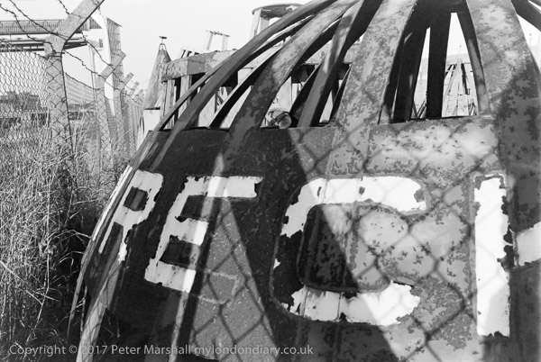
85-10m-52: Wreck Buoy, Sammy’s Point, 1985 – River Hull
Another view of the buoy storage yard of ABP Humber Estuary Services at Sammy’s Point on the site now occupied by The Deep.
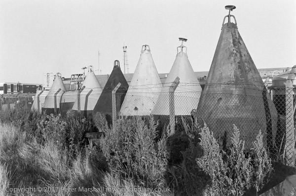
85-10m-53: Buoy storage yard, Sammy’s Point, 1985 – – River Hull
A curious affect of sunlight shining directly into the camera lens, something which every photographer was taught to avoid, the effects of which in the days of film were impossible to predict but almost always thought to ruin the image.
Knowing this, I still took the picture, and rather like its many faults, though it is an image that really remained unprintable without the use of digital scanning and processing, over thirty years later.
The kind of marbling effect in the lower left quarter reminds me of the scales of some fish, which seems appropriate, and there is a subtle gradation in the greys of the distant view with the ship passing the mouth of the River Hull on its way down the Humber, with the pier and the trees. The full-size image has a sharp and prominent grain exaggerated by the over-exposure and has something of the feeling of a mezzoprint.
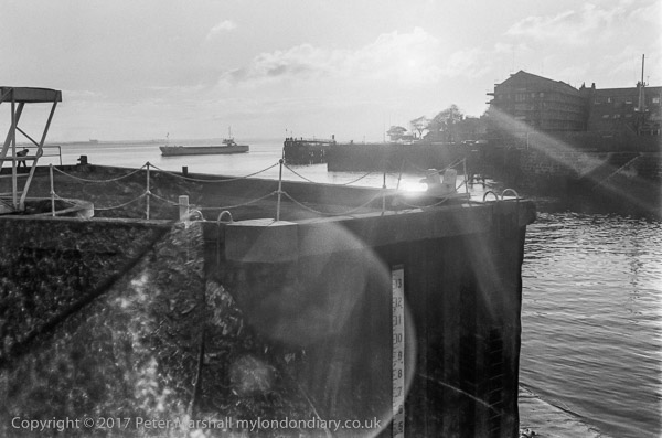
85-10m-54: The mouth of the River Hull, 1985 – River Hull
A Ford Anglia, a ship’s boat on a roof and a large shed at the premises of Allen R Worfolk, Ship Repairers & Marine Engineers on the bank of the River Hull at Tower St.
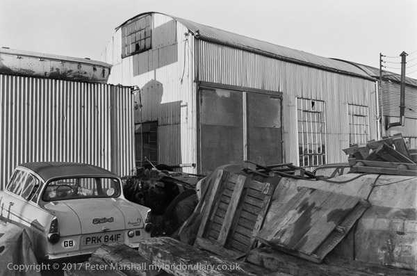
85-10m-55: Allen R Worfolk, Ship Repairers & Marine Engineers, Tower St, 1985
Mooring buoys (I’m told by Iain Ralph in a FB post they are Admiralty 3 point mooring buoys) on the derelict land that was once a part of the Victoria dock estate close to Sammy’s Point near South Bridge Road. This area, like much of the land around the dock was formerly a timber yard.
I can’t positively identify the structure behind the two buoys at right of centre, perhaps a former dock gate on its side, nor the buildings in the distance at left which have a boat on the ground in front of them, though I think these are close to the Humber entrance to Victoria Dock.
The area where this was taken is probably now a part of the car park for The Deep.
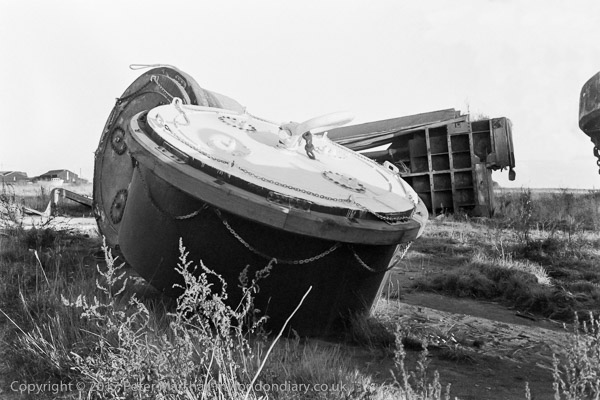
85-10m-56: Mooring buoys etc on land, Victoria Dock, 1985 – Docks
Another picture taken deliberately into the sun, but with less drastic light effects. The pier is in the background, and behind it the buildings of Albert Dock, with a ship moored at the riverside quay. There are a could of small vessels by the pier (one possibly the pilot boat) and a larger one on the other side of the Humber.
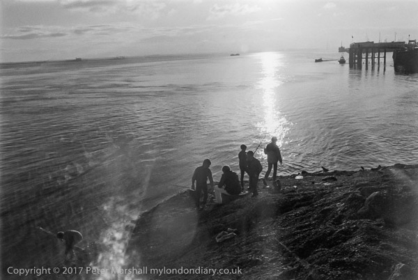
85-10m-61: Boys fishing at Sammy’s Point, 1985 – Humber
A short telephoto lens gives a closer view of the pier and just avoids much flare from the direct sun (which lightens the left edge) though this has resulted in over-exposure. One of the boats in the previous picture is now heading up the River Hull.
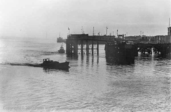
85-10m-64: Victoria Pier from Sammy’s Point, 1985 – Humber
Hull Central Dry Dock is still there, though now underneath a new event venue. When I took this picture there was a ship inside it being worked on. Holy Trinity Church is still much the same, though now renamed Hull Minster. At the right of the picture is a small dredger, with the river then being regularly dredged, while now the mud has been allowed to build up considerably.
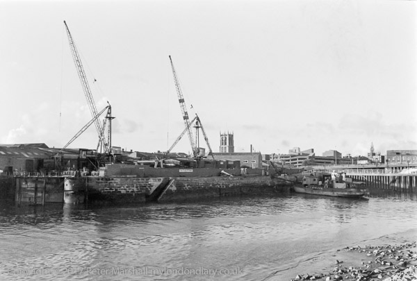
85-10m-66: River Hull, Dry Dock and Holy Trinity from Sammy’s Point, 1985 – River Hull
______________________________________________________
There are no adverts on this site and it receives no sponsorship, and I like to keep it that way. But it does take a considerable amount of my time and thought, and if you enjoy reading it, a small donation – perhaps the cost of a beer – would be appreciated.
My London Diary : Buildings of London : River Lea/Lee Valley : London’s Industrial Heritage
All photographs on this and my other sites, unless otherwise stated, are taken by and copyright of Peter Marshall, and are available for reproduction or can be bought as prints.
To order prints or reproduce images
________________________________________________________