Another digest of daily posts during Hull2017 on Facebook, about the pictures added daily on the intro page at Hull Photos. Comments and corrections to the captions and texts about the pictures are always welcome here or on Facebook.
Hull Photos
17th November
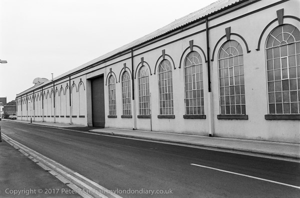
The view towards the east end of the dock with the Lord Line building, distinctive post-war offices for the trawler owners, which are currently being allowed to decay and when I visited in February were left open for vandals.
The Lord Line building deserves listing because of its part in Hull’s heritage and reasonably distinctive architecture, and it was sad it was not included in the 10 new listings announced to celebrate Hull2017 – and it is arguably rather more deserving than some that were included.
The tower of the Grade II listed hydraulic power accumulator stands out from the cluster of buildings at the right, but most of the other buildings have since been demolished, along with those to the left of Lord Line. Harpmyth Limited became Hytec Electrical (Hull) Ltd in 1984 and was wound up in 1992. Its postal address was North East Corner, St Andrews Dock, Hull, HU3 4S.
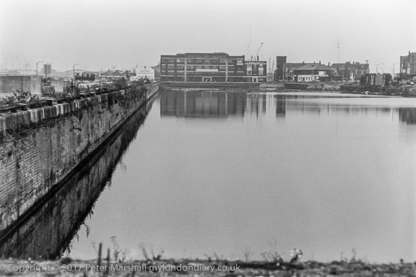
85-10k-24: St Andrew’s Dock & Lord Line building, 1985 – Docks
18th November
Taken from the identical viewpoint as the previous image, these two views were probably intended to be seen as a panoramic image of St Andrew’s Dock. Although the dock had closed ten years earlier there was still considerable business going as as the parked cars and vans indicate. The River Humber is on the far side of these buildings and the fence at right.
Only a single building still stands on the south side of the dock, and I think it is hidden by other buildings in this picture.
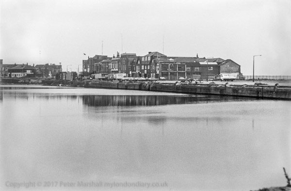
85-10k-25: St Andrew’s Dock, 1985 – Dock
19th November
A third view of St Andrew’s Dock, taken from a similar position at the north-west corner of the dock, but where I stepped back to include some of the rotting north dockside. The extension dock was to the right of this picture, with a channel at the south side leading through to it.
Hull’s ‘Billingsgate’ or Fish Market was formerly on the quayside here, but presumably moved with the trawlers to William Wright/Albert Dock in 1975. A new ‘state of the art’ market, ‘Fishgate’, was opened in 2001, but it sold mainly fish from the Icelandic fleet, and in 2011 they moved their sales to Grimsby.
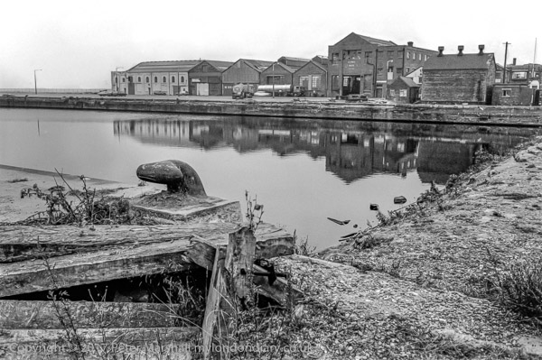
85-10k-26: St Andrew’s Dock, 1985 – Dock
20th November
Another view of those curiously wrapped pillars which support the Clive Sullivan Way viaduct over the roundabout. The large striped shed in the background is still there on Brighton St in the Brighton St Industrial Estate, though there are now other buildings in front of it, and is or was part of the Birds Eye factory with the Norbert Dentressangle logo on it.

85-10k-55: Under Clive Sullivan Way, St Andrews Dock roundabout, 1985 – Docks
21st November
This rather distinctive industrial building was built in 1898 as Hull’s main tram depot when the city got permission for an electric tram system. It seems to have been built as a church to industry. After the trams stopped it was used by buses and then as a store by KHCT, known locally as the Ball Bearing or ‘Bolly’ Shed. Although still in good exterior condition when I photographed it, it later became derelict and a playground fro local kids and was eventually demolished and the whole area is now Asda.
In the background at left is a long factory building which again seems to have disappeared.
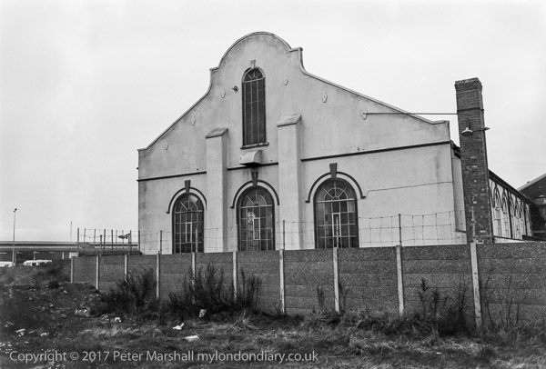
85-10k-62: Former City of Hull Tramways depot, Liverpool St, 1985 – Hessle Rd
22nd November
Hull corporation got permission from Parliament to construct and operated an electric tram system in 1896, and the first rail was ceremonially laid in June 1898. Siemens supplied the electrical equipment and the system used an unusual centre groove rail from Belgium. The Liverpool St depot in the pictures was built in 1898 as the main depot and workshop, and a number of the trams were built their until 1925. The first trams ran along Hessle Rd on July 5th, 1989 and they were replaced by trolleybuses between 1936 and 1945 and the building became a bus depot.
Over the years the name changed from City of Hull Tramways to Corporation Tramways in in 1919, then in 1931 to Hull Corporation Transport. In 1945, after the trams were replaced by buses it became Kingston upon Hull Corporation Transport, and finally in 1975 Kingston upon Hull City Transport or KHCT. The lack of any signage on this and the previous image suggests it might have been no longer in use when I took the photograph.
85-10k-63: Former City of Hull Tramways depot, Liverpool St, 1985 – Hessle Rd
23rd November
At the left is the newly built Clive Sullivan Way, named after his death in 1985, but built as the South Docks Road, and the road leading down to the roundabout at the end of Brighton St. These sidings used to lead to the docks but were retained when the area was redeveloped.
I think the large factory building just to the right of centre is still there on the Brighton St Industrial estate, but there are many more recent buildings around. Just one rail line remains and all the track on the right side has gone.
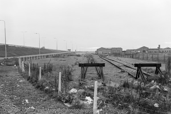
85-10k-65: Railway Sidings, near Brighton St, 1985 – Hessle Rd
24th November
Tower St is on the East side of the River Hull and now runs to The Deep, and the boats and buildings in this picture are all gone, except for the Tidal Barrier at top right of the image.
Hull is mainly built on land that was reclaimed from salt marsh, and around 90% of the city is below high tide level. The city is under threat from flooding both by the tide from the Humber and water from the River Hull and the water draining from its extensive catchment area. Various civil engineering works since medieval times have been carried out both to stop this flooding and drain the land for agricultural use, with lengthy drains discharging into the River Hull and the Humber, and banks built up along the river.
The tidal barrier, built in 1980, is lowered when exceptionally high tides are expected (though everyone in Hull believes that the first time after it was completed it was needed those responsible forgot to do so.) But at least since then it has protected the city, though it was a close thing in 2013, and some parts of the dockside flood walls were overtopped, and have now had a couple of feet added to them.
But Hull is still vulnerable to flooding from exceptional rainfall in the hinterland, and in 2007 8,600 homes and 13,000 businesses were flooded.
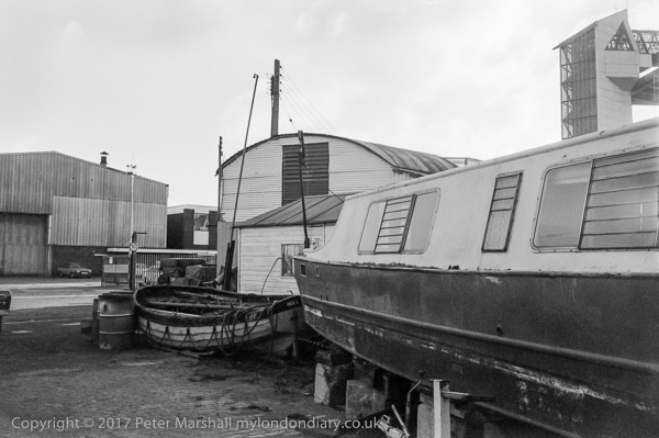
85-10l-12: Boats in yard and Tidal Barrier, Tower St, 1985 – River Hull
You can see the new pictures added each day at Hull Photos, and I post them with the short comments above on Facebook.
Comments and corrections to captions are welcome here or on Facebook.
______________________________________________________
There are no adverts on this site and it receives no sponsorship, and I like to keep it that way. But it does take a considerable amount of my time and thought, and if you enjoy reading it, a small donation – perhaps the cost of a beer – would be appreciated.
My London Diary : Buildings of London : River Lea/Lee Valley : London’s Industrial Heritage
All photographs on this and my other sites, unless otherwise stated, are taken by and copyright of Peter Marshall, and are available for reproduction or can be bought as prints.