30 March 2017
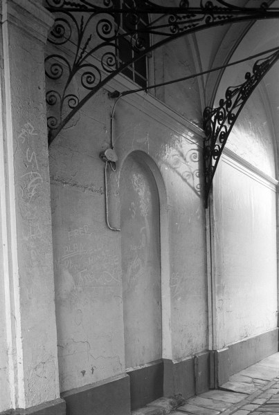
At left are the Pease warehouses, built in 1745 and 1760 and being converted in to flats in 1981. Joseph Pease was involved in almost every business based in Hull, and set up its first bank here. He invested in ships, whaling, insurance, oil seed crushing, cotton spinning, making whiting, paint and soap.
Another prominent Hull family were the Listers, who were lead merchants. Two John Listers, father and son, were Hull MPs in the 17th century, and the house now know as Wilberforce House was built for the younger of them around 1660 on land by the River Hull they had owned since around 1590. Lister Court, at the right of this picture was built as a warehouse around 1880.
Pease Court was Grade II listed in 1954, and Lister Court in 1994.
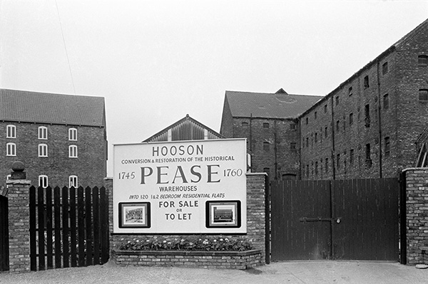
28×24: Pease Warehouses & Lister Court, High St, 1981 – Old Town
31 March 2017
Spurn point, with the North Sea at left and Spurn Bight and the Humber at right looks bleak, even though this picture was made in August. It is around 30 miles by road from Hull, and on this occasion the weather was poor and we didn’t stay long, deciding to turn around and go to Withernsea rather than driving further on.
Several years later we visited in better weather and walked out and picnicked on the sands around the point.
This was then the narrowest point, but Spurn now is sometimes cut off at high tides, and is called Yorkshire’s only island, though Whitton Island perhaps has a better claim to that title, even if a tiny sliver belongs to the other side. And of course there are many other islands in Yorkshire rivers including Howden Dyke Island.
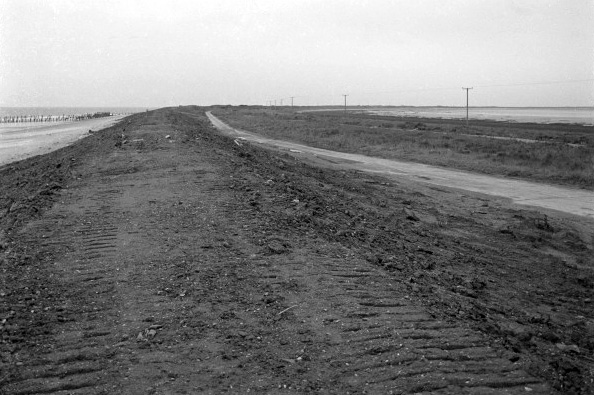
32l21: Spurn Point, 1982 – Humber
1st April 2017
The Humber Bridge seen from Barton-upon-Humber. We drove across the bridge and walked around Barton a little, but I think it was a Sunday and everything was closed. I photographed a giant knot outside Hall’s Barton Ropery (it closed a few years later in 1989 and is now and arts centre), and then we walked down to the shore and west far enough for me to take a photograph of the bridge, filling the foreground with a small lake and reeds.
On the full-size image I can make out the Lincoln Castle, beached on the foreshore at Hessle as a restaurant, just to the left under the lowest point of the suspension wires, and further to the right some of the taller blocks of Hull are visible on the horizon.
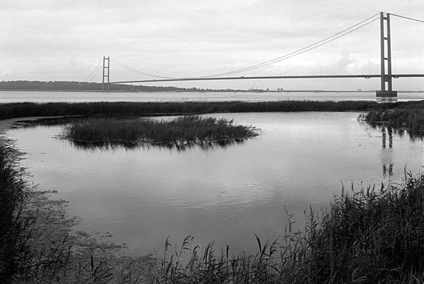
32l56: Humber Bridge from Barton-upon-Humber, 1982 – Humber
2nd April 2017
The area to the right of Humber Dock Basin, now part of Humber Quays, was once joined from Wellington St by a bridge across a channel, Albert Channel (also known as ‘Paraffin Creek’) which led from Humber Dock Basin to Albert Dock Basin, but this was largely filled in when I took this picture and the draw bridge had disappeared, though I think you can see the gap into which it was once lowered at the extreme right.
Further west the Albert Channel had been filled in to ground level and the island re-united with the mainland, but this area, used as a parking area for lorry trailers and a single boat, was closed to the public.
The name of the boat, Hull registered H428, is hard to read on the full size image, but looks like ‘Glenhelo’ or possibly ‘Clenhelo’; I haven’t managed to find any more about it. Another view, taken from a higher viewpoint, probably from inside the customs watch house by the Minerva Pier, then a heritage centre but now private flats, looks across this area to the Albert Dock entrance.
This area is now a part of Humber Quays.
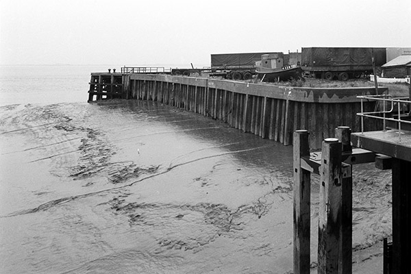
32m42: Humber Dock Basin, 1982 – Old Town
3rd April 2017
The gateway from Princes Dock St into Hull Trinity House, was the entrancew to Trinity House School, but now leads into a public car park, Zebedee’s Yard, named in memory of Zebedee Scaping, headmaster of that school from 1854 to 1909.
Hull Trinity House was officially founded as a guild in 1369, though it had apparently already been in existence for a couple of hundred years. It was associated with Holy Trinity, Hull’s parish church and is a charity for masters, pilots and seamen with a school, Trinity House School, almhouses, grants to needy seafarers and an outdoor education centre. It has an extensive collection of objects and records, including personnel records for the entire Hull Fishing Fleet from 1946 on. It gets an income for its work from a number of shops and office properties.
Trinity House School and this gateway was built here in 1842, modernised in 1956 and extended upwards in 1973, but the school moved out to George St in 2013 and the buildings inside the yard were demolished to provide a public car park. The gateway was Grade II listed in 1952.
32m52: Gatehouse to Trinity House School, Princes Dock St, 1982 – Old Town
4th April 2017
Wagons inside the dock area would be mainly moved either by horses or gangs of men, or could be pulled by chains or ropes around capstans from hydraulic winches or locomotives. They also turned wagons through 90 degrees on turntables like this, moving them at the end of the dockside onto rails leading out from the dock, where they would be coupled into trains. Maps show there was an extensive system of rail tracks in the area, particularly into the large goods shed of the Railway St Goods Station which was on the site of Hull’s first railway station.
At left is one of the dockside sheds of Humber Dock Basin, and to the right the outer gates of Humber Dock, with the Minerva pub (circa 1820, Grade II listed) and Waterguard Offices, 1909 (a customs watch house, now private housing.) The dockside in front of these was Steam Packet Wharf, one of many locations in Hull from which goods and passenger services once ran. The Minerva pier can just be seen beyond , along with two curious round-headed cylinders, part of the hydraulic mechanism for opening and closing the dock gates.
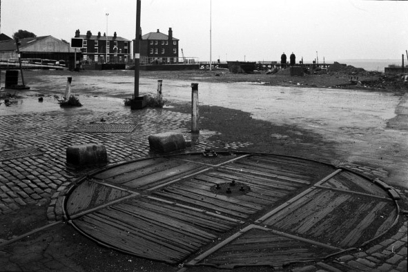
32m56: Wagon turntable, Railway St/Wellington St, 1982- Old Town
5th April 2017
The picture was taken where Bankside swings away from the River Hull, around the large paint factory and between it and the gas works. The wharf was in good condition but appeared to no longer be in use. A bend in the river means that this view is loooking roughly east. Hull Exhaust Centre is still here, but the all of the buildings framed inside the metal arch have gone.
Those at the left were part of the paint factory, now all gone, and there is now a new road, Innovation Drive which runs past the the left edge of the newer shed beyond the arch which is now the only building of the Exhaust Centre; the wharf is now a car park.
Paint was produced in Hull at least as early as the 1730s by Joseph Pease and there was a significant breakthrough in 1791 when John Kirkby Picard began the manufacture of white lead, previously imported from Holland (though made from lead mined in Derbyshire) in Lowgate. The paint industry flourished in Hull from the early 19th century with famous names including Sissons Bros (established 1803) and Henry Blundell (1811).
Paint manufacturers Storry Smithson & Co Ltd and Sissons Bros & Co built factories along Bankside around 1830, but later the whole area became Sissons works. Largely destroyed by wartime bombing their new factory was built in a 1930s style and opened in 1953. The works closed around 1990 and were demolished in 1994, with the loss of the building and its famous trademark mural showing two painters carrying a plank a typical example of the failure to conserve the city’s heritage.
You can read more about Hull’s paint industry (and much more of Hull’s history) at www.paulgibson.com. Though no longer active in the UK, the Sisson’s name is still important in paint in the Caribbean, Far East and elsewhere.
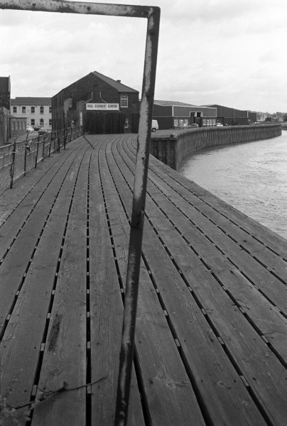
32m64: Wharf & Hull Exhaust Centre, Bankside, 1982 – River Hull
You can see the new pictures added each day at Hull Photos, and I post them with the short comments above on Facebook.
Comments and corrections to captions are welcome here or on Facebook.
______________________________________________________
There are no adverts on this site and it receives no sponsorship, and I like to keep it that way. But it does take a considerable amount of my time and thought, and if you enjoy reading it, a small donation – perhaps the cost of a beer – would be appreciated.
My London Diary : Buildings of London : River Lea/Lee Valley : London’s Industrial Heritage
All photographs on this and my other sites, unless otherwise stated, are taken by and copyright of Peter Marshall, and are available for reproduction or can be bought as prints.