Down River

This was the River Hull from Drypool Bridge back in 1977, in what was known as the Old Harbour, in use from before Hull had docks, and still in use in 1977. Those barges in the foreground were moored in front of Rank’s Clarence Mill, one of Hull’s great landmarks,  rebuilt after being almost completely destroyed in the war.

That same waterfront, seen looking upriver towards where I took the earlier picture in February this year is rather different. There are only two vessels moored and one of those is the museum ship Artic Corsair, Hull’s last surviving sidewinder trawler, bought by the council in 1993 and now occasionally opened to the public. The other at right is the Dovedale, built as an inland tanker in 1962 that has clearly seen better days.

There are three new bridges across the Hull, two of them footbridges and the other carrying the heavy traffic of the A63, including much going to and from Hull’s King George V dock, as well as a tidal barrier.

And past the tidal barrier at the mouth of the river is of course now The Deep, a major visitor attraction.  The message on the side of the Tidal Barrier was an art installation which enabled people to put up their slowly scrolling messages on it. Hull has always suffered from flooding, with much of the area being very close to sea level and reclaimed from marshland. The tidal barrier keeps out tidal flooding, but the dramatic floods in the summer of 2007 in which almost 8,000 homes were flooded and 1300 businesses effected came from heavy inland rainfall converging on the area and swamping the rivers and drains.

A day later I joined around twenty other  people for a ride on the most recent bridge, the footbridge at Scale Lane, which was designed to allow people to be on it while it swings around through about 90 degrees to leave the river clear.

Of course with little or no river traffic, there is seldom a real need for the bridge to open,  but it still has to be able to open – along with the other bridges across the River Hull – if a vessel requests passage.  Last week in an art event as part of Hull2017, all 13 bridges between East and West Hull were opened together for a minute at the Autumn Equinox (or technically around 45 minutes before it), splitting the city in two. There is considerable rivalry between the two halves and some Hull residents would like the opening to be permanent – and one listed bridge has been open permanently since 1994.

The bridge rotates around an axis close to the west bank of the river, where a curved walkway remains in contact with the land, but the other end swings out across the river, with gates on the approach and on the bridge itself being closed seconds before the bridge begins to open. It then moves slowly and steadily, fully opening in a minute or so before moving back and into position again. It isn’t exactly a thrilling ride, but interesting and free  and once or twice a week (times on the Hull corporation web site) makes sure that the bridge will still work.

More pictures
River Hull
A Ride on Scale Lane Bridge

Continue reading Down River

Hull at Night

Most nights Hull goes home early, and much of the centre seems deserted. Presumably at closing time people stagger out of the pubs, but until then the streets are eerily empty. Certainly on a Thursday evening when I was taking these pictures, though things liven up a little at the weekend.

There is one car in my picture of North Bridge, though I think about the only one we saw as we crossed it, and that solitary figure appears in several of my pictures as she was walking around with me.

You can see her again in Humber St, the centre of Hull’s ‘Fruitmarket’ area, which no longer sells fruit but is touted as “Hull’s modern, vibrant & unique cultural quarter, open all day every day“. It may be open all day, but it was pretty deserted at night in February.

You can see her too reading the plaque under King Billy. And in the background there is a single cyclist and just a few distant cars. The square in front of Holy Trinity was deserted (though there was a regiment of orange barriers) as was Prince St and Posterngate, and it was only as we came to Trinity House Lane that we saw the first pedestrian, scurrying quickly away.

Whitefriargate was empty too, with just one or two people around Monument Bridge, and I didn’t have to wait to get pictures of Queen Victoria Square without people – I didn’t particularly want to have the square empty, but it was, apart from some large object that had been left across it.

This wasn’t taken in the early hours of the morning – when I was fast asleep in bed. This was early evening, around 7pm. Where was everybody? You can see a few more pictures from this walk, and see these larger – at Night in the Old Town, though you won’t find many more people.

Obviously, these are panoramic images, though the format isn’t extreme, quite a good fit to my wide-screen monitor with just a small empty strip at top and bottom. I don’t much like extreme panoramic formats, though I do like panoramic images. These use the same cylindrical perspective that I’ve used since I bought my first swing-lens camera in 1990 – an expensive Japanese model.  And although I’ve admired some of the more extreme angles of view used in some images, I’ve seldom wanted to use them myself. These pictures have a horizontal angle of view of around 145 degrees, a little greater than my old Widelux.

Despite being taken at night, I didn’t use a tripod – all are handheld. Tripods are quite useful with panoramas; you need them not to hold the camera steady, but to hold it absolutely level. Even small deviations can make some images unusable. But I’m an impatient man and like to keep things as simple as possible, concentrating on the image rather than technicalities. So though I own several tripods of widely varying size and utility I seldom disturb the dust on them; worthwhile tripods are always too heavy to carry.

A tripod would have enabled me to use a lower ISO and reduce the noise in the images, but I quite like a bit of noise in night pictures, it adds to the mood.

Continue reading Hull at Night

Hull Photos: 1/9/17 – 7/9/17

Pictures added to my Hull Photos site from 1st -7th September as a part of my ‘picture a day’ project for #Hull2017, Hull’s year as UK City of Culture. Clicking on any image will open the page on Hull Photos where the picture is shown larger. You can follow my daily image posts on Facebook or on Hull Photos. Comments are welcome here or on Facebook.

1st September 2017

It’s hard to see now exactly the location of this picture, which on my contact sheet it labelled Foredyke Path, thought it should be simple given that there are three bridges shown.

I think the framing arch is a bridge under the disused Hull to Hornsea line, the distant bridge and embankment are the Hull Docks line, still in use, but can’t work out why there is a footbridge, apparently on the line of the path, which I think followed the Foredyke Stream drainage ditch, culverted a few years earlier and now part of the Hornsea Cycle Route which forks off around here. Other rail lines in the area were the branch to Withernsea and some sidings to mills which ended close to Cleveland St.


84-4d-12: Foredyke Path and railway bridges, 1984 – East Hull

2nd September 2017

Another visit to Queen’s Terrace in 1984. Number 1 and 3 Queen’s terrace still appear possibly to be occupied, though the off-licence had I think closed for good, and the sheet of ply lying across the doorway at right suggests this was no longer in use.

This was one of many small shops which had served what had been a densely occupied area of working class housing. Some of the area had been cleared following war-time bombing but much still remained until the council demolitions. There are still some shops on the opposite side of Sculcoates Lane, but others have been converted to private houses.


84-4d-65: Queen’s Terrace, Sculcoates Lane, 1984 – Beverley Rd

3rd September 2017

Another view of what I think from the brickwork is probably again Queen’s Terrace, but possibly another street in the same area, awaiting demolition in April 1984. One house appears still occupied, with net curtains at its windows while the rest of the terrace has doors and windows blocked with corrugated iron to prevent squatting. The one remaining door has the number 1 on it, but may have lost another digit.

Looking at existing terrace rows in the area and elsewhere in Hull you can see the various different treatments of the brickwork which mark the different streets or parts of streets. The arch above each of these doors and windows required ore than 20 bricks to be cut to shape and the windows needed specially shaped glass panes, all of which must have added considerably to the labour of construction. This part of the street appears to have been re-roofed and I suspect would originally have been slate.


84-4d-63: Queen’s Terrace, Sculcoates Lane, 1984 – Beverley Rd

4th September 2017

There are still some pipes which cross Wincolmlee a few yards north of where I took this picture but this section of the wall and the bridge across from Holmes Halls Tanners to their wharf, as well as their buildings on the right have gone, replaced by some parking space and featureless modern sheds or cladding on older buildings and a used car sales yard. But the building with the chimney and much of its wall is still there, as this is the former Sculcoates Goods Station, also Grade II listed.

Further in the distance the listed Wilmington Swing Railway bridge survives, and now in rather better condition. Rix’s oil tanks have grown and what was then Pauls Agricultural Products silo – now Maizecor – on Wincolmlee is still visible.


84-4d-66: Holmes Halls Tanners and River Hull, Wincolmlee, 1984 – River Hull

5th September 2017

In my book ‘Still Occupied’ this was wrongly identified as Morley St, but it is actually Glass House Row, further south off Cleveland St. The buildings on the right side of the street can still be identified, and closer inspection shows that some of the windows have been altered from their position when I took the picture. The industrial structure and the large building at the end of the street are now longer there, but the more distant buildings are still recognisable, as the large block next to the Bankside Cafe at 330-338 Wincolmlee.

According to the informative Wikipedia article on Wilmington, Glass House Row was named for the short-lived Hull Glass Company, set up in 1846 but which had failed by 1850. Later on the street were the Anglo-American mill (1879-80) and the Bon Accord Mill (1895), both apparently oil mills set up by brothers John and James Stephenson which later become part of BOCMM, who stopped milling at both in 1929-30, though Bon Accord went back into service for a couple of wartime years, ending in 1942.


84-4e-03: Glass House Row, 1984 – River Hull

6th September 2017

Teal & Mackrill Ltd are still in business on Lockwood Street, famed for their specialist marine grade varnishes, topcoats, undercoats, primers, anti-fouling and bilge paint. The company was established by Arthur Teal and Mr Harold Mackrill in 1908 and became a limited company in 1913. Still an independent family run company it has around 75 employees and makes around 1.5 million litres of paint a year, mainly for marine and agricultural use, including many specialist paints.

Paint manufacture was a major industry in Hull, with some major brands having factories close to the River Hull, though I think all have now moved away or gone out of business, while this specialist firm remains.

Both the paint on the nameboard and on the side of the building at right seems not to be the best advertisement for their products. Only the taller building at extreme left remains, the rest of the building having been replaced with a doubtless more practical but rather blank metal-clad large shed, its blue paintwork in excellent condition.

Somewhere on the buildings – I’ve only seen pictures – is a large mural originally commissioned for the 1949 Hull Industrial and Trades Exhibition by Patricia Mackrill who had just graduated from Manchester Art School, which was displayed in Hull City Hall.


84-4e-13: Teal & Mackrill Ltd, Lockwood St, 1984 – River Hull


The loggia at the rear of West Garth, Newland Park, Hull

One of my late friends in Hull was a member of the Mackrill family, though I think with no involvement in the paint business. I knew Ian first in London, where after a legal career he became a psychotherapist but late in his life he bought another home in Newland Park, Hull and after a few years moved back into a large house there, West Garth, where he had lived for some years as a child. One of the finer examples of Arts & Crafts houses in Hull, he was unfortunately unsuccessful in getting it listed despite carrying out considerable work to restore it to its original state. It does get a brief mention in Pevsner’s volume on Hull. I and more often my wife stayed with him there on a number of visits to Hull in the 2000s.

7th September 2017

Extensive drainage is needed of land all over the catchment of the River Hull, much of which is close or below the level of the river at high tides, full of carrs, waterlogged areas often covered with trees such as alder and willow, and ings or water meadows and marshes. An extensive system of drainage developed over hundreds of years with the first recorded dyke being the Eschedike linking the Abbey at Meaux to the River Hull, built both for drainage and navigation in 1160-82. Later more drains were built discharging excess water into the River Hull or Humber at low tides, and one of the larger of these was the ‘Barmy’ drain, built following the passage of the Beverlev and Barmston Drainage Act in 1798.

Despite all the work done over the centuries – including building the tidal barrier to stop tidal flooding, Hull is still prey to flooding, and large areas suffered in the 2007 floods caused by torrential rain which led to 17,000 homes being affected, with 10,000 people having to be evacuated.

For many years the drain was a water playground for the children of Sculcoates, many of whom learnt to swim in it, though I think this is very much discouraged now, perhaps because over a hundred people are said to have drowned in it, some committing suicide. It is supposedly home to the mythical ‘Beast of Barmston’, half man and half dog.

I don’t know anything about this mural, which includes Mr Winn’s Post Office & General Stores and the Outreach Arms, but it was at the rear of buildings on Northumberland Ave, and the pitched gable end and roof at right is I think the rear of Trafalgar Motors, while the larger roof in front is the back of what is now Ralph’s Autos. The picture is taken from the footpath beside the drain which runs along what used to be the Hull & Barnsley line into its Cannon St terminus.

The town shown on the mural looks nothing like any part of Hull I know, and unlike Hull is overlooked by distant hills. The canal scene is also rather inappropriate for what is a drainage ditch and was never I think used for navigation.


84-4e-16: Beverley & Barmston Drain, 1984 – Beverley Rd


You can see the new pictures added each day at Hull Photos, and I post them with the short comments above on Facebook.
Comments and corrections to captions are welcome here or on Facebook.
Continue reading Hull Photos: 1/9/17 – 7/9/17

Hull Promenade

If you read my posts here or on Facebook regularly you will certainly be aware that 2017 is Hull’s year as UK City of Culture. And that as my personal contribution to the year that I’ve been posting another picture every day to my newest web site, Hull Photos, also known as ‘Still Occupied – A View of Hull‘, the title of a show I had in the city in 1983 in which around 148 of the pictures appeared.


Half Tide Basin and entrance locks, Victoria Dock, 1982

So far I’ve added 406 pictures to the site, rather more than the days of the year so far, as I put pm quite a few pictures before the start of 2017. But every day, usually more or less straight after breakfast, I sit down at my computer, write the code (I have to alter 4 files) and then FTP the day’s new image into place. It’s become a daily ritual, sometimes something of a challenge, especially when I’m away from home, but a little bit of structure I’m sure I will miss when we get to 2018. The latest picture is always shown on this page, as well as on its final resting place in the site, but it’s best to follow the year on Facebook as I usually post some text about it there – and you can comment.


Half Tide Basin form the entrance locks, Victoria Dock, 2017

But of course I had to visit Hull during this special year, and although I’d hoped to find time to go several times, so far I’ve only managed 5 days in February. We had an eventful journey to Hull, parts of which I’m probably not allowed to tell you much about, which involved me traveling alone from Kings Cross to Hull with an empty reserved seat next to me, with my wife taking a later train which was diverted via Selby while the train I was on was kept standing at Kirk Sandall while several rail staff on board argued with a young man who had run across the track to board the service and appeared not to have a ticket. Finally we moved on to Hatfield & Stainforth where a police officer was waiting on the platform, and, over an hour late we finally arrived at Hull, around 20 minutes after Linda got there.

We’d sold Linda’s parental home to pay for her mother’s upkeep in an old people’s home back around 2000, and our old friend with a stately home in the north of the city we were always welcome at died a few years ago, so this year we were staying in digs in the Victoria Dock estate, comfortable enough and only a very short walk from the Old Town thanks to the recent Scale Lane footbridge. We got there, dumped our cases and went out for a walk.

I’d not been to Victoria Dock for over 25 years and it was something of a shock to se what had been a largely open and derelict area turned into a suburban estate, if one with some reminders of its previous life, with the dock entrance and Half Tide Basin retained as a feature.

And while the old Hull had a number of piers, it now has a Promendade, and it was one we had virtually to ourselves on a glorious dramatic winter afternoon.

Siemens, whose ‘blade’ was then dominating Queen Victoria Square in the city cwntre have taken over Alexandra Dock, providing welcome employment, and I suppose the loss of the public footpath on the edge of the Humber there is a small price to pay, but it was a disappointment to find our path blocked there, with a long diversion. Instead we turned back towards the city centre. past The Deep and across the footbridge there to the Minerva for a pub meal.

More pictures: Victoria Dock Promenade
Continue reading Hull Promenade

Hull Photos: 25/8/17 – 31/8/17

Keeping up the daily postings throughout August, particularly when I was away from home presented a few minor problems, taking me back to hand-coding the web pages in my text editor and having to work off-line and then walk a short distance to get internet access, and I was pleased not to have missed a single day putting both the added image on my Hull Photos web site and also making these postings to my Facebook page – where you can read them daily. Comments are welcome either to this digest post or the daily Facebook posts

25th August 2017

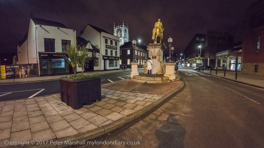
The lifesize statue of Hull’s first mayor was commissioned for the new Town Hall in 1868 from Hull sculptor William D. Keyworth and unveiled in 1870. After the Town Hall was demolished in 1913 it was moved to its position here on Nelson St in 1920. It was Grade II listed this year as a part of Hull2017.

Inscribed on the pedestal is

SIR WILLIAM DE-LA-POLE,
KNIGHT BANNERET
FIRST MAYOR OF HULL, A.D. 1332-1335.
AN EMINENT AND MUNIFICENT MERCHANT,
HIS SOVEREIGN’S FRIEND, THIS TOWN’S BENEFACTOR,
LORD OF MYTON AND OF HOLDERNESS,
BARON OF THE EXCHEQUER,
FOUNDER OF THE CHARTER-HOUSE, HULL,
ANCESTOR OF THE NOBLE FAMILY OF SUFFOLK
HE DIED 21 APRIL 1366.

And on the plinth:

PRESENTED TO THE CORPORATION OF KINGSTON UPON HULL,
BY ALDERMAN ROBERT JAMESON J.P.,
MAYOR 1870-1871, 1871-1872, 1872-1873.

William de la Pole, Hull’s first Mayor, was a wool merchant and financier of both King Edward II and King Edward III, responsible for commandeering and commissioning ships for the King in the Hundred Years War and in 1339 was created a Knight Banneret and also Baron of the Exchequer. He represented Hull in Parliament, and with his son Michael established the Maison Dieu hospital in Hull and a Carthusian monastery – which later developed into the Charterhouse.

The sculpture has deteriorated in its exposed position here, and is probably best seen from the rear as it looks a little silly from the front – tastes in sculpture have rather changed. He seems to be looking down Queen St towards Hull’s Parish Church of Holy Trinity – now upgraded to Hull Minster, again for Hull2017 CoC.

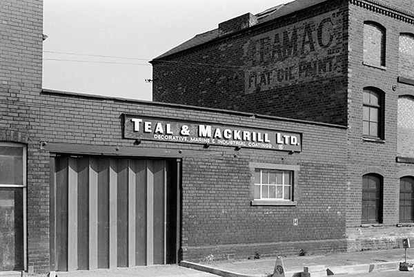
The scaffolding at left is on the Grade II listed 1819 Pilot Office, disgracefully sold off for development and conversion to flats in 1998 after the privatised Associated British Ports decided that the property of the Humber Pilots belonged to them. The scaffolding in 1983 was for a refurbishment with the aid of a £2,000 grant from the Lord Mayor and City Council. The opposition by the pilots to the redevelopment is seen by some as the reason for ABP replacing the independent pilots by its own employees in the bitter dispute in 2001-2.

The Oberon pub at right, 44 Queen St is now a block of luxury flats – and the empty site at extreme right has been filled.


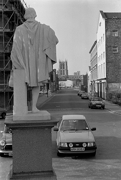
36s05: Nelson St, looking down Queen St, 1983 – Old Town

26th August 2017

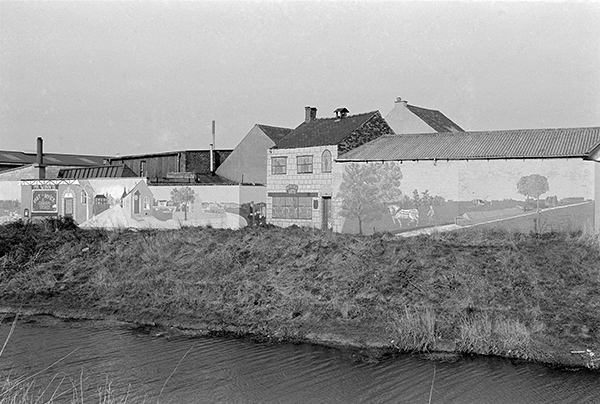
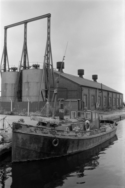
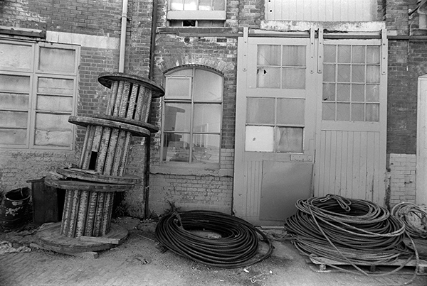
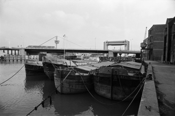
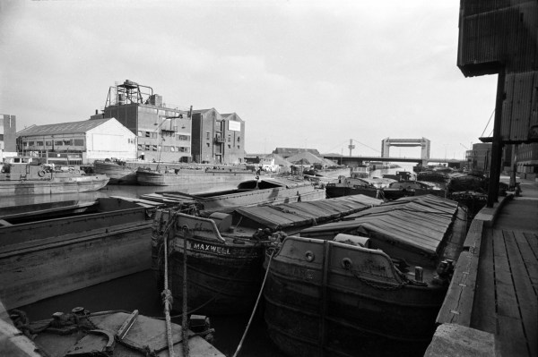
The smoke house was built in the 1930s for C & J Horowitz & Co. Hull and the Hull and Humber Bacon Smoking Company, so it is perhaps not entirely correct to call it a fish smoke house, though this being Hull I’m sure it would also have smoked fish.

As names like Wellington St and Nelson St indicate, this area was developed in the early 19th century, reclaimed from the river marshes by the dumping of spoil from the excavation of Humber Dock (the dock was constructed from 1807-09), starting around 1804 though only named officially around ten years later.

The smokehouse was in an enclosed yard between Wellington St and Humber St and I couldn’t find a way to get a closer picture of it, and it was obviously in a semi-derelict state. The remaining the property along the north side of Wellington St including the sheds shown here were demolished in 2014/5. The south side had been rather badly redeveloped earlier, presumably after the closure of Humber Dock to shipping in 1967. The area around Humber St and Wellington St remained the centre of the wholesale fruit and vegetable trade, which had began when most arrived at Humber Dock, but by the time it closed mainly coming in lorries along the A63 a short distance north.

Before then these premises had been occupied by Brooksbanks Fine Foods, suppliers of potatoes, fruit and vegetables to the catering industry, and are now being replaced by rather bland blocks in the area now called the “Fruit Market” (which it no longer is), described by an estate agent as “a unique, characterful and stylish new community, combining premium residential developments with a vibrant retail, leisure and arts environment“, and where a one bedroom flat will cost you around twice as much as in other areas of central Hull.

There are nine fish smokehouses in Hull’s local list, none of which have national listing, and this one, recently restored for £133k by Hull City Council with an English Heritage grant is perhaps the least good example – and the restoration has made it into something of a joke. It was deeply disappointing not to see at least one of the other better examples listed in the ten properties selected for Hull’s year as UK City of Culture. It is perhaps another example of where a more significant local input might have been preferable.


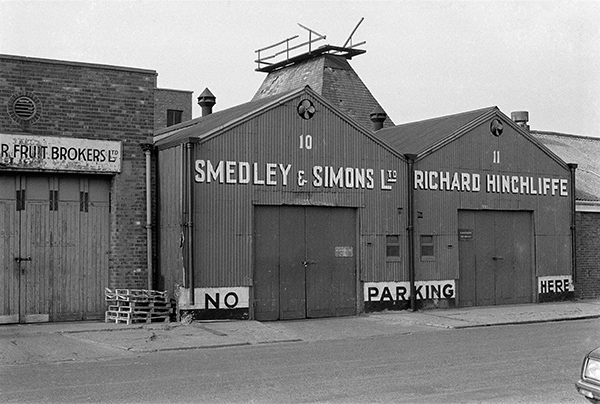
36s06: Fruit merchants and Smoke House, Wellington St, 1983.

27th August 2017

A closer view of a building on Scott St extending to its corner with Catherine St that in previous post I identified as “built as the Vulcan Iron Works (unsurprisingly a common name for iron works) for Tindall & Co, Ironfounders. Around 1900 it was owned by Messrs Tindall, Earle and Hutchinson Ltd, Marine and General Engineers who among other things made engines for steel screw ships. In 1904 the works was divided and sold; among the occupants after this was H Smith & Co, Electrical Engineers.

It appears from this picture to be in reasonable condition and as I commented before could have been converted to other uses rather than demolished, along with other buildings in the area.


36s13: Former Vulcan Iron Works, Scott St, 1983 – River Hull

28th August 2017

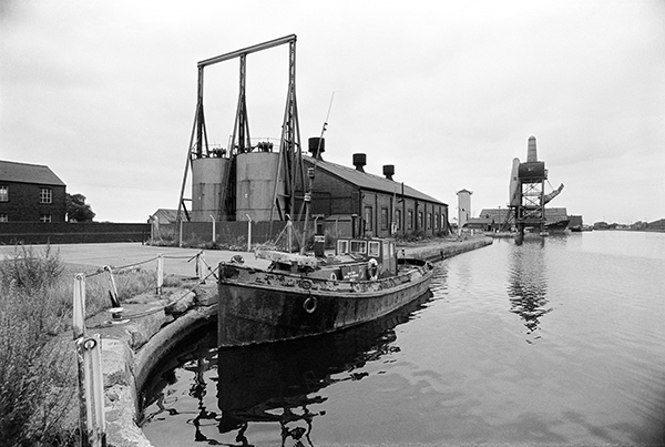
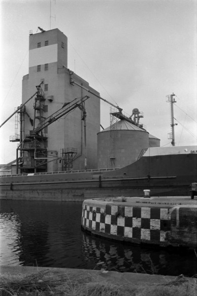
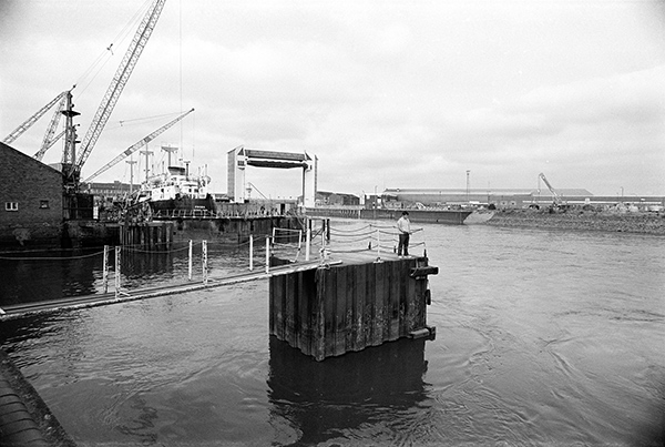
These horizontal storage tanks have long gone from their site just north of the junction with Hodgson St, their site taken by a small office building for the bulk storage company, IBL Bulk Liquids formed close to here in 1947. The larger vertical tanks at both edges of the picture can still be seen, along with two horizontal tanks a few yards further up the road. There web site states they have “some 120 storage tanks, with individual sizes ranging from 50 to 1,700 cubic metres and a total capacity of around 34,500 cubic metres” in Hull at two sites on the River Hull and in the port area at King George V dock.

The tanks can handle a wide range of liquids, from edible oils to “aggressive and sensitive materials”.

Much of the industry that developed along the River Hull was concerned with oils, in the early days with whale oil and later until the present day with the extraction of vegetable oils, as well as in recent years waste oil reclamation.


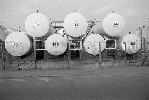
36s25: Bulk Liquid Storage, Lime St, 1983 – River Hull

29th August 2017

I photographed this office on Great Union St, roughly opposite Hyperion St on several occasions because of its links with Hull’s heritage. The site is now occupied by The Crossings, a centre for the homeless which opened in 2011.

Surprisingly in 1983 it seemed a little tidier than in the previous year, though with the same plinth and posters. I wrote at some length about the Ruston marine engine and the poster of the coaster Surreybrook, next to the advert for PoLadaire who supplied the equipment that enabled deep sea trawlers to freeze fish at sea.

There were now several pieces of equipment on the display stand, and what I think is probably a heat exchanger proudly sitting on top of what had previous been an empty plinth.


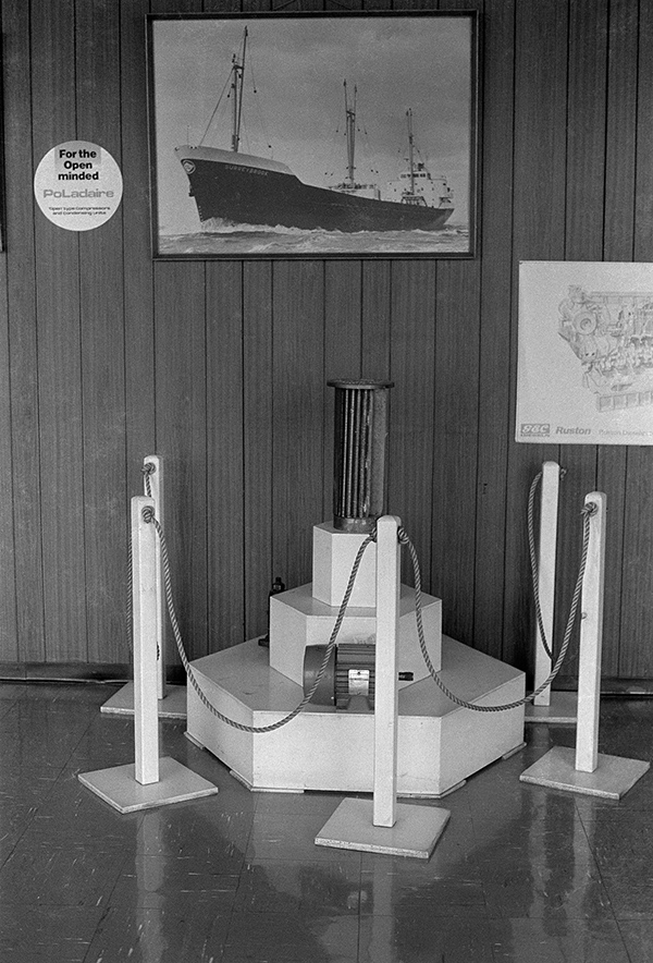
36s31: Great Union St, 1983 – East Hull

30th August 2017

Companies House list the HULL SHIPS STORES(HOLDING)LIMITED as active from 06 Mar 1950 – 31 Dec 1976 and then continuing under the name to the HULL SHIPS STORES COMPANY LIMITED until 26 Oct 1987.

No 19 Bond was presumably a bonded warehouse where goods could be stored before clearing customs and paying import duties, VAT etc. The goods can only be removed when the appropriate duties have been paid.

This site is now occupied by L A Hall, Roofing Contractors and Merchants, whose gate also has an instruction to use the entrance in Spyvee St.


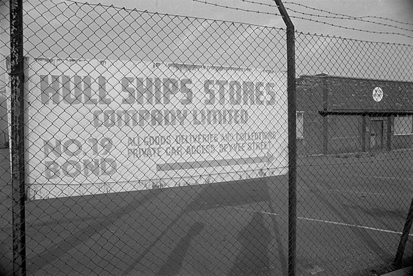
36s33: Hull Ships Stores Company No 19 Bond, Lime St, 1983 – East Hull

31th August 2017

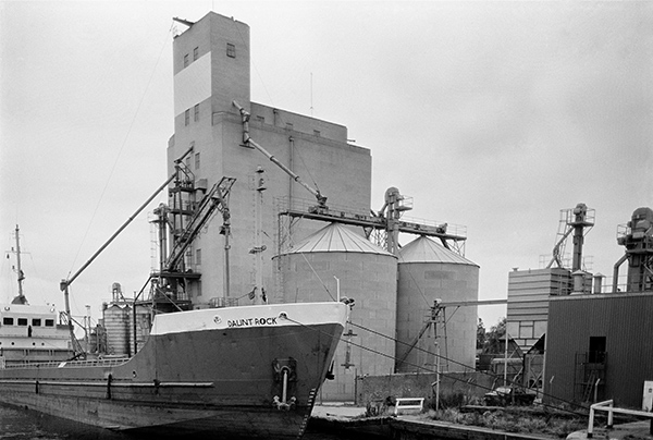
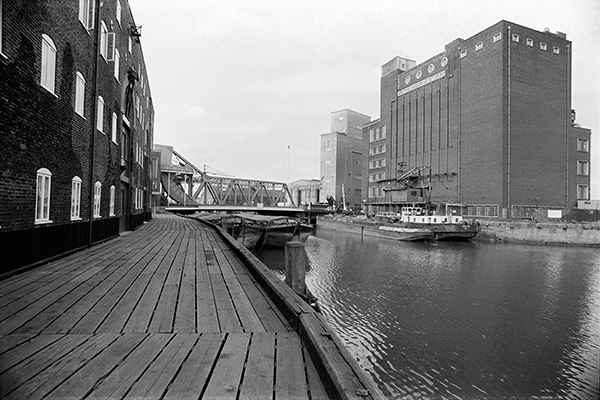
Rank’s Clarence Mill, destroyed by bombing in 1941 were rebuilt after the war only to be senselessly demolished in 2016, shamefully destroying one of Hull’s landmark buildings. The section of the mills upstream, here with a Rank Hovis logo, remains, now occupied by cartridge manufacturer Shotwell.

Two small tankers from John H Whitaker’s fleet are moored in front of the mill, and two lighters, one the ‘R50’ and a small tug on the closer bank. A part of Drypool Bridge can just be seen at the left edge.


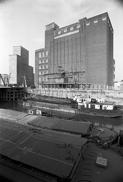
36s54: Clarence Flour Mills and River Hull, 1983 – River Hull


You can see the new pictures added each day at Hull Photos, and I post them with the short comments above on Facebook.
Comments and corrections to captions are welcome here or on Facebook.
Continue reading Hull Photos: 25/8/17 – 31/8/17

Hull Photos: 18/8/17 – 24/8/17

18th August 2017

When the first Hudson Ward mill was built on this site, it was on the bank of the canal – the Aire and Calder Navigation – that made Goole a port for Yorkshire, linking it to Knottingley, Leeds, Sheffield and South Yorkshire. In 1910 the canal west of Barge Dock was widened to form South Dock.

Barges could bring cereals on the extensive canal system to Hudson Ward’s mill in Goole Docks from a wide area around, and grain from the USA and Canada could be brought by ocean-going large vessels for transhipment from Hull Docks by smaller vessel. Barges could also be used to distribute the mills products, flour, sharps, bran, flaked maize and a complete range of compounded foods for pigs, cattle and poultry.

The vessel berthed at the mill is the Daunt Rock, 892 tons and 64 m, long with beam 10.8 m, built in 1976 at Hancocks Shipbuilding Co. Ltd at Pembroke Dock and registered in Cork (where Daunt Rock is a hazard to navigation close to the harbour mouth.) In 1988 she was renamed Cornet and in 2001 Zila. In 2011 she was reported to be still sailing under the Panamanian flag, but her current status is listed as “Decommissioned or Lost”.


36l33: Daunt Rock berthed at silo, South Dock from Bridge St, Goole, 1983 – Goole

19th August 2017

The view from the bridge along South Dock with the Hudson Ward mill at right, and the moored Gaunt Rock in the centre. At the left in the distance is one of Goole’s trademark buildings, No. 5 hoist for the ‘Tom Puddings’, compartment boats developed by William Bartholomew in 1863, bringing coal to Goole to be loaded into ships. Each compartment could hold about 40 tons of coal, and they were towed in trains normally or 21, sometimes up to 38. Trains often had be be split to go through the locks.

There used to be five hoists at Goole and they could load up to around 300 tons of coal an hour. They were last used in 1986 when No 5 was Grade II* listed.


36l34: South Dock, Goole, 1983 – Goole

20th August 2017

A view along the south side of South Dock from close to the Bridge. The boat moored a few yards down is I think an old steam tug and a board on it (partly obscured by a rope) says Acaster’s Water Transport Goole, a company still listed as supplying two tugs on the Humber web site and based in Swinefleet in Old Goole.

Beyond that is the entrance to No. 2 dry dock and then No. 5 Hoist. The ship moored just past this is I think partly in South Dock Basin which is I think the inlet where the ‘Tom Pudding’ compartments were stored. The rather odd tower to the left of the hoist is still standing, and there are still large sheds beyond – Sheds 44 and 45 of the Caldaire Terminal opened in 1999, which I think are modern replacements for that in my picture.


36l43: South Dock, Goole, 1983 – Goole

21st August 2017

A tighter view of the Acaster’s Water Transport tug in South Dock and the shed behind. There is a name on the lifebeltm but I can’t make it out. The first two letters at the top could be SV (for steam vessel?) but this is followed by an unreadable letter, possibly A, then T,O and some more I can’t read. Only a part of the lower letting is visible, with the first four letters clearly ROCH, perhaps the start of Rochester or Rochdale…


36l45: South Dock, Goole, 1983 – Goole

22nd August 2017

The entrance to Associated British Ports Goole with a barrier on a ramp, and on the building in the centre the message ‘No Public Allowed’. The dock visible in the distance is I think Ouse Dock, but I’m not exactly sure in which direction this picture was taken.


36l52: Associated British Ports entrance, Aire St, 1983

23rd August 2017

Another picture from Bridge St showing South Dock, Daunt Rock and the Hudson Ward mill. I’ve never been too good at holding a camera level, and would probably have straightened this up in printing, but I’ve left it, as correcting would lose the hoist at the left edge of the image.


36l55: South Dock from Bridge St, 1983 – Goole

24th August 2017

The sign points to Shed 37 which is on the north side of Ouse Dock, and Lowther Bridge joins this dock to the rest of Goole Docks. This was one of the early entrances from the Ouse through Packet lock (replaced by the larger Victoria Lock in 1881) for the numerous steam packets.

There was a larger ship entrance (Ship Lock into Harbour Dock – both now filled in) and then into Ship Dock, and then into Ship Dock, as well as a Barge Lock leading into Barge Dock. Ship Dock and Barge Dock were opened out where there had previously only been a narrow channel and Ocean Lock constructed from Barge Dock to the river to take larger ships in 1938, replacing both Ship Lock and Barge Lock.

There is a public right of way across the Lowther Bridge but I think in 1983 any signs to it had been fairly well hidden by ABP which had recently taken over the docks when they were privatised.


36l66: Associated British Ports entrance, Aire St, 1983


You can see the new pictures added each day at Hull Photos, and I post them with the short comments above on Facebook.
Comments and corrections to captions are welcome here or on Facebook.
Continue reading Hull Photos: 18/8/17 – 24/8/17

Hull Photos: 11/8/17 – 17/8/17

Another week’s postings from August:

11th August 2017

Another view of the swing bridge across the entrance lock to the former fish dock. St Andrew’s Dock had been built with the coal trade in mind, but was opened in 1883 as the fish dock, and remained in that use until 1975, when the fishing fleet moved to nearby Albert Dock.

The area around the lock was designated as a conservation area in 1990, but the Lord Line building – trawler owners offices built in 1949 – is only locally listed. In May 2017 Hull Council issued an enforcement order against the building’s owners telling them to make it safe and secure after many photographs taken inside the building and on its roof had been published. The owners response was to put in plans to demolish both this building and the nearby listed Hydraulic Tower and Pump House, which environment officers have rejected.

Although people in Hull welcomed the recent listing of around ten Hull buildings in recognition of its year as UK City of Culture, many were disappointed that Lord Line and the also the threatened huge ‘Three Ships’ mosaic on the former BHS store were not also protected.

Most of the other buildings visible in the picture have now gone. In the distance at the left of the picture you can see the distinctive chimneys of two of the fish smoke houses.


36k54: Swing Bridge, St Andrews Dock entrance and Lord Line building, 1983 – Docks

12th August 2017

Water still remained in St Andrew’s Dock, though the entrance was now closed by the roadway across it. The main part of the Lord Line Building was I think empty, though people still seemed to be working in some of the other buildings around where cars and a van and a lorry are parked.

The Lord Line building was still in good condition, with not a single broken window. On its frontage are the names of some of the companies which used it – British United Trawlers Limited, Marconi Marine, J Marr & Son and another I can’t quite read.

At the end of the road are trawlers in William Wright Dock. Of the buildings on the right only the listed hydraulic tower remains. The Lord Line building has been deliberately left open to vandalism for years but its basic shell appears sound.


36k55: St Andrew’s Dock, Lord Line Building and road, 1983 – Docks

13th August 2017

St Andrew’s Dock had been the fish dock since it opened in 1883 until it was abandoned in 1975, with what remained of the fishing industry moving a short distance east to Albert Dock.

Those that remained of the businesses around the dock moved with it, leaving empty buildings, some dating from the 1880s, and they quickly deteriorated.


36k61: Abandoned buildings, St Andrew’s Dock, 1983 – Docks

14th August 2017

CEA Towne Ship Riggers Ltd is a family firm founded in 1948, becoming a private limited company in 1951, and still trading as the Towne Group. The plates by the office door show it was also the registered office for Charles Towne Agencies Ltd and ‘Ropes & Rigging Ltd’ presumably all part of the group. The bottom plate is for the Fleetwood Trawler Supply Company Ltd which was set up in 1912 to supply Fleetwood trawlers with oil burning navigation lamps and also provided sheet metal work, ships rigging, sail making, chandlery and provisions, and which became a part of the Towne Group, which also includes a farm on Hull Road in Skirlaugh.

The business of the companies has changed somewhat with the end of the fishing industry; some of the companies are now longer active but the Towne Group is now particularly involved with lifting equipment.


36k65: CEA Towne (Ship Riggers) Ltd, St Andrew’s Dock, 1983 – Docks

15th August 2017

Empty cable drums and coils of rope on the dockside at St Andrew’s Dock. The reflection in the window shows a fish smoke house and what I think is a part of the trawler owner’s offices in the Lord Line building.


36k66: Abandoned workshops, St Andrew’s Dock, 1983 – Docks

16th August 2017

I was fascinated by the texture and marks on this wall and the tall, slim post embedded in the concrete path in front of it on a corner of Lime St, to the east of the River Hull, and photographed it on several occasions. There was something about the vertical stains coming down the wall with their diffuse edges and the precise edge of the post, as well as the square aperture in the wall, and there always seemed a peculiar quality of light here, with the tall and fairly light coloured wall acting as a huge reflector.

There was a certain mystery about it. Lime St now has no walls, no posts like this.

Lime St is said to have got its name from the time when the processing of whales was one of Hull’s main industries. There were pits of quicklime beside the river where the whales were rendered down. It was an industry that gained the street the reputation of being the smelliest street in England. It was still a street lined on both sides by industrial premises – including the wharves along the River Hull on its west side – when I took this picture in 1983.


36l24: Post and Wall, Lime St, 1983 – River Hull

17th August 2017

The first of a few pictures from Goole, which I visited briefly. The port of Goole was always linked with that of Hull, as well as being a competitor, with barges taking goods between the two. Goole has its canal connections with West Yorkshire and beyond while Hull was closer to the sea and has docks for large ocean-going vessels.

The silo now helpfully has the name Hudson Ward across the top and is the Hudson Ward mill; it was perhaps being repainted when I took this picture in August 1983. The company are flour millers and manufacturers of animal foods of all kinds and came to Goole in 1885. On 31st December 1893 the partnership between Thomas Francis Hudson, Robert Robinson, and Thomas Hanley was officially dissolved and the business carried as the Hudson, Ward and Company Limited, Flour and Corn Merchants and Millers at the Dock Mills, Goole.

Robert Robinson was a farmers son, born in 1846 at Thorne Levels and worked on his father’s farm until he bought a flour mill at Conisborough in 1870 with his father-in-law T F Hudson. Four years later he rented a mill at Doncaster with Thomas Hanley, which unfortunately burnt down in 1881. They bought a mill at Retford and rebuilt the Doncaster mill.

The mill at Goole was opened around 1885 and cost around £18,000 though possibly older existing buildings on the site were used as offices. The rather plain silo in my pictures I think probably dates from the 1930s, built alongside the original six storey brick building which had many more windows and electric lighting and was demolished probably in the 1970s. Hudson Ward were formed when Robinson retired, spending a few years travelling abroad and later becoming a well-known Doncaster councillor and Mayor from 1902-3. He was also a leading Methodist in the area, as were several of Hull’s leading industrialists.

The major part of the wheat used for flour milling is brought up the river in the firm’s fleet of barges direct from trans-Atlantic ships in Hull and discharged in bulk into this large 4,000-ton silo on the north side of Goole’s South Dock.


36l32: Daunt Rock berthed at silo, South Dock from Bridge St, Goole, 1983 – Goole


You can see the new pictures added each day at Hull Photos, and I post them with the short comments above on Facebook.
Comments and corrections to captions are welcome here or on Facebook.
Continue reading Hull Photos: 11/8/17 – 17/8/17

Hull Photos: 4/8/17 – 10/8/17

I’ve managed to keep posting an image a day over the holiday period, despite some problems with accessing WiFi when away from home, but I’ve rather got behind in posting the weekly digests of posts. So this is the first of several posts in an attempt to catch up over the next few days.

4th August 2017

One of the upper rooms in the Pilot Office on the corner of Nelson St and Queen St was built to give the pilots a clear view up the Humber for incoming vessels, and doubtless they would sit or stand there with a telescope waiting for their turn to go out in the pilot boat to meet them. But on this occasion the launch had been out in the Humber and had then come in and was waiting at the riverside, next to the horse wash before setting off to meet the ship. The view out from the Pilot Office along the estuary is now blocked by The Deep.

The ship’s name appears to be Simone, and there are several ships of that name, but all I can find details of were built after I took this picture in 1983. She has the letters RNO large amidships.


36i24: Humber pilot boat Camilla speeds off provide a pilot, 1983 – Old Town

5th August 2017

This area close to the mouth of the River Hull was Hull’s ‘Old Harbour’, lined with warehouses and wharves. I was standing close to the end of Scale Lane – where the new footbridge is to take this picture. There are more boats behind these front four, including I think a couple of the redundant lightships from the Whitton Sands, replaced a year or two earlier by solar-powered unmanned lights.

A crane is mounted on a platform jutting out from one of the warehouses, but I think will no longer have been in use. The river walkway is still there but the varied buildings which made for an interesting townscape have been replaced by an anodyne apartment development, unpleasant though not particularly ugly but lacking in character

From left to right the four boats are named Onward Pioneer, Maureen Anne W, Iveco and a crudely written SFS. The Maureen Anne W was built in 1964 at Hessle or Thorne by Dunston’s as the Hessle Flyer II, used as tranport between their two yards, and renamed Maureen Anne W in 1978. Around 2010 the tarpaulin covered open hold was converted into living accommodation and the wheelhouse rebuilt in Hartlepool.


36i31: Boats in Old Harbour, Myton Bridge and Tidal Barrier, River Hull, 1983 – River Hull


6th August 2017

A man stands on a curious lump in the River Hull looking at the swirling water and I hoped he was not about to jump in. I decided not to follow him out on the rather flimsy looking bridge from the end of Nelson St.

Proba from George Town in the Dry Dock was a sizeable ship of around 1500 tons, around 268ft long and 40 ft wide, a coaster built by Ailsa Perth Shipbuilders at Troon for Wm.Robertson Shipowners Gem Line in 1962 and seemed to pretty well fill the dry dock. I think she was floating when I took this picture and soon to leave to pick up cargo in the King George V dock. She was named Tourmaline until 1982 when she became Proba until 1986, then had a string of names – Fergus H, Socotra, Sorocco and finally in 1993, Akram V, under which name she was converted into a tanker. At the time of the photograph she was owned by Concord Leasing Ltd of Brentford in West London but registered at Georgetown in the Cayman Islands. The ship was stranded off Malaysia in 2009 and is thought to have been broken up at Chittagong in 2011.

The dry dock is now the event venue Stage@TheDock, where the Proms did an afternoon concert last month. I think the stage is actually above the dock, which is still visible at each end. Also last month the Tidal Barrier was one of several building given Grade II listed status.

The bank to the right of the picture is Sammy’s Point and from 1849-1864 the site of Martin Samuelson and Co one of Hull’s best-known shipbuilding yards which built around a hundred iron ships in 10 years and was one of the pioneers in using steel for shipbuilding. It later became a timber yard for Victoria Dock and appears to have a number of buoys stored. This is now the site of Hull’s popular visitor attraction The Deep.

36i35: Mouth of the River Hull, Tidal Barrier and Hull Central Drydock from Nelson St, 1983 – Old Town

7th August 2017

Although there was still some river traffic on the Hull, many of these vessels were apparently moored here awaiting disposal

The Humber Princess, the largest vessel in the picture, moored on the far bank, a 380 ton Oil Products Tanker built in 1979 for John H Whitaker (Tankers) Ltd of Hull (“Industry leaders in bunker logistics for over 120 years”) is apparently still in service, her last reported position in Stanhope Dock, Goole a day ago. She was built just a little upriver in Hull at the Yorkshire Dry Dock.

Some of the other vessels will have been sold and converted into houseboats and others simply broken up.

None of the buildings on the far shore have survived, with the exception of the large light-coloured shed, which I think is still there though rather altered, the premises of John H Whitaker (Holdings) Ltd on Tower St.


36i41: The Old Harbour, River Hull, 1983 – River Hull


8th August 2017

Both the Pease Warehouse, tastefully converted into flats and Drypool Bridge, recently given a paint makeover to celebrate mathematician John Venn, born in Hull but who moved away almost as soon as he could walk, are listed buildings and have survived.

Unfortunately Joseph Rank’s Clarence Mill, rebuilt after wartime bombing was not listed and was demolished early in 2016, despite being one of Hull’s best-known landmarks. A solid building which could well have been converted to other uses – like the warehouse opposite – it was to have been replaced by an ugly hotel in time for Hull’s year as UK CIty of Culture, but that failed to materialise and the site remains empty and the riverside path fenced off. The half of the Rank’s site on the other side of the bridge which was manufacturing animal feed under the trade name Blue Cross still remains, now making shotgun cartridges.


36i55: Drypool Bridge, River Hull and Clarence Flour Mill, 1983 – River Hull

9th August 2017

This was a fairly typical sight in the Old Harbour on the River Hull back in 1983, with barges moored along the wharves at the rear of the High St. On the East bank of the river in front of a sand and gravel wharf is Bowprince, a 1,485 ton suction dredger, built by Ailsa at Troon in 1964 and in 1983 London registerd and owned by British Dredging (Sand & Gravel) Co Ltd. Like so many of the ships in my pictures she came to an unfortunate end; after being sold to Madeira Island in 1991, where her name was changed to Bom Príncipe she sank and was lost there. This was apparently not her first sinking – she had in around 1968 sunk in the Thames above Greenwich after a collision with the coal coaster Blackwall Point.

Gilyott And Scott Ltd were incorporated as a company in 1901 and liquidated around 1993. John Scott was born in Beeford, a village between Bridlington and Hull, in 1827 and was a lighter owner long before the company was formed. For a time the company also operated a fleet of lorries. They were a major owner of tugs and lighters in Hull certainly after 1964 when they brought together the companies of William Gilyott, John A. Scott, T.F. Wood, Furleys and John Deheer.

There were a number of barges in the Poem series, and several others appear in my Hull photos. Twite was one of a class named after bird species.


36i56: Poem 21, Bow Prince and Twite in the Old Harbour, 1983 – River Hull

10th August 2017

The Neptune Inn was first recorded in 1817 and closed in 1979 and was boarded up awaiting demolition – which finally took place a couple of years after I photographed it. The name of the licensee, J A Lancaster was still written above the door which bears the single word ‘BAR’. Previously an older picture by another photographer shows rather more ornate doors on both sides in keeping with the pub frontage.

The pub – taken over from a local brewery chain by Worthingtons in 1897, was known as the ‘Little Neppy’, perhaps not just because of its diminutive size, but also because there was from 1797 a Neptune Hotel in Whitefriargate, built by Hull’s Trinity House for merchants landing at the newly built dock, opened in 1778 and now Queen’s Dock Gardens.

That Georgian building survives, with a blue plaque about its history, though it soon failed as a hotel being too grand and too expensive for Hull, and it was Hull’s Custom House from 1815-1912. Since the 1930s it has been leased by Boots and the staff canteen was in the former Banqueting Hall.

Neptune St is still there, leading to the Albert Dock but I don’t recall where on it this pub once stood. A small and homely pub, it used to be popular, certainly up to the 1970s, being close to the docks, Smith & Nephews, Sanderson’s paint works and various fish dealers.


36k-34: Neptune Pub, Neptune St, 1983 – Hessle Rd


You can see the new pictures added each day at Hull Photos, and I post them with the short comments above on Facebook.
Comments and corrections to captions are welcome here or on Facebook.
Continue reading Hull Photos: 4/8/17 – 10/8/17

Hull Photos: 28/7/17-3/8/17

A few from Goole as well as some from Hull. Comments welcome on any of these pictures.

28th July 2017

Taken from the swing bridge between Bridge Rd and South Bridge Rd at the entrance to West Dock. Shed 23 has since been demolished. Around the corner is Stanhope Dock, built in 1891 as the ‘New Extension Dock’. The dock had a crane capable of lifting railway wagons and emptying them into the hold of a ship before placing them back on the rails. Now the track ends at Bridge St, and West Dock is the only dock served by rail. At left is the bridge pit.

Berthed in Stanhope Dock is Jurgen, a 444 ton coaster built in Hamburg in 1956 and originally named Heinrich Knuppel; it then became Heinrich Raap in 1966 before being renamed Jurgen in 1966. It had capsized and been written off in 1971 while loading timber in Finland, but was salvaged and back in service the following year for a company registered in Limassol, Cyrpus. Its troubles did not end there and on 5th March 1986 half way between Boston and Antwerp it was in collision with a Yugoslav bulk carrier, MV Kotor in the North Sea around 40 miles off Walcheren Island at the mouth of the Scheldt Estuary. It sank and is still on the sea bottom in around 40 metres of water.


36h51: Shed 23, West Dock Entrance, Goole Docks, 1983 – Goole

29th July 2017

I think this door and windows were facing Bridge St on the west end of Shed 23 which was on the north side of the entrance to West Dock. The reflection in the window shows several cranes and stacks of timber, presumably across the road along the North side of West Dock.


36h52: Detail, Shed 23, West Dock Entrance, Goole Docks, 1983 – Goole

30th July 2017

There is still a ‘Shed 20’ on the south side of West Dock, but it looks nothing like this. Along with most of the other sheds around the docks these old wooden structures have been replaced by more modern sheds. There are now two sheds here, Shed 20 and Shed 21, and I think this view was probably taken from Lower Bridge St and from the same position would now show Shed 21.

In the foreground are two conveyors, presumably used of the bulk handling of solids such as sand or gravel, and behind them a lorry load shrouded in a tarpaulin stencilled ‘Wrights Transport Goole’. Fred Wright started the business in Selby in 1938 and ran it with his brother Charles. It remained a family business, and Graham Wright took over in the 1960s, moving to Goole in 1978, and his two sons worked in the business, which was sold up in 2004 when Graham Wright retired. The auction raised £600,000.


36h64: Shed 20, West Dock from Bridge St, Goole, 1983 – Goole

31st July 2017

A crane holds 4 sacks in mid-air over the hold of the Jurgen berthed in Stanhope DOck in front of Shed 25 while behind 2 men stand waiting on the platform of a lorry. They and the crane-driver are slowly loading or unloading the vessel, and it looks as if the job could take several days. It’s easy to see why containerisation rapidly swept away the old-fashioned ways of handling goods like this – and the modernisation of the docks has meant that the dockside sheds have also gone. The space where Shed 23 was is now empty, while a blander modern structure has replace Shed 25.

The Parish Church of St John the Evangelist is still there – and the very visible lightning conductor going up its spire to the cross on top may well have helped.

Shed 25 replaced the Lancashire & Yorkshire Railway “Ghent and Antwerp Shed” and Bergline began working from it in 1972, providing regular freight services to Sweden etc. The company appears now to have disappeared.


36h66: West Dock Entrance, Stanhope Dock, Shed 23 and Shed 25 from West Dock Bridge, 1983 – Goole

1st August 2017

I think I felt that the tilted camera was somehow appropriate for the dilapidated state of the pier when I took this picture.  Or perhaps it was just grabbed rapidly as the seagulls flew off as I approached.

Rather than repairing the pier, a a layer of some kind of board had been nailed over part of it and a fence put up to stop people falling down the gaps outside. It perhaps reflected a general attitude of neglect and half-hearted attention to the heritage of the city.


36i11: Seagulls at Hull Pier, 1983 – Old Town

2nd August 2017

Shifting mud in the River Humber makes navigation tricky and shops require pilots to make a safe passage up the river.  The earliest UK laws about pilots date from around 1200 and members of Hull Trinity House, founded in 1369 were pilots, although it was not until 1512 that they formally undertook to act as pilots to bring ships into Hull.  The Humber Pilot Act of 1800 gave Trinity House the authority to appoint pilots and 30 men working from 6 pilot boats were licenced.

From 1812 to 1998 the Humber pilots worked from a fine purpose-built office at 50 Queen St, but were evicted when this was turned into flats in 1998. In 2001, the independent Humber Pilots went on strike against plans by Associated British Ports (the private company who took over when British Transport Docks Board was privatised in 1982/3) who had decided to train and employ their own pilots. All 150 independent pilots had their licences revoked in 2002 ending 490 years of independent pilotage on the Humber.


36i22:  Pilot boat Camilla waiting at Nelson St, 1983 – Old Town

3rd August 2017

This view of the pilot boat was taken from the Horse Wash at Nelson St. The ‘Oss Wash’ is a wide fairly gently slope down to the river inset into the river wall here where tradesmen would bring their horses to wash them down, presumably drawing water from the Humber using buckets on a rope or even taking them down into the river to wash and then walk back up the wide slope.  I think old photographs show some railings coming out at intervals from the river wall around half way across the wide slope to divide it into a number of stalls, but these had gone.

All ships greater than 60 metres in length are required to take on a pilot to ensure safe passage up the Humber estuary unless the master or first mate is a Pilotage Exemption Certificate Holder. This service, provided from 1512 to 2002 by independent Humber Pilots is now provided by the privatised Associated British Ports. Very Large Ships need two pilots

Fees depend on tonnage, and as an example, for a vessel of up to 300 tons there is a charge for pilotage from Hull to Goole of £267.39 and also a boarding/landing fee of £104.47. Larger vessels pay more.


36i21:  Humber pilot boat Camilla waits off Hull Pier, 1983 – Old Town


You can see the new pictures added each day at Hull Photos, and I post them with the short comments above on Facebook.
Comments and corrections to captions are welcome here or on Facebook.
Continue reading Hull Photos: 28/7/17-3/8/17

Hull Photos: 21/7/17-27/7/17

21st July 2017

If it wasn’t for Sky Sports the Whalebone Inn would be a near-perfect pub. When I took these pictures it was a Tetley’s pub, which didn’t endear it to me, but it now has a good range of real ales. While the memorabilia make it something of a museum, so too apparently do some of the regulars. Back in 2010 writer and film-maker Dave Lee described it in his blog as “probably the city’s last remaining example of a true docker’s pub; it has traditionally been frequented by them and most of the current clientele seem to be former fishermen.”

I think the pub has gone through several phases of closure and internal reorganisation, but its exterior has seen relatively few changes. The blank wall at the left now sports a door and windows, that dreaded ‘Sky Sports’ banner was hanging there, and there are new notices including a new decorated large name board replacing the Tetley’s name sign across the frontage and the hanging pub sign with its sailing ship has gone.


36g26: Whalebone Inn, Wincolmlee frontage, 1983 – River Hull

22nd July 2017

The first railway bridge on this site was built in 1853, to carry the Victoria or East Dock Railway over the River Hull. A single line bridge with speed and axle load restrictions it became inadequate to deal with the growing traffic to the Eastern docks as well as that going to Hornsea and Withernsea, and was replaced with a twin track bridge, with Hull Corporation paying the extra needed to provide a foot and cycle way along its north side. From 1864 it was also used by trains from Hull to Hornsea on the Hull and Hornsea Railway which diverted from the Victoria Dock Branch at Wilmington Station just to the east of the bridge.

This old footbridge and cycle path is now longer in use, instead there is a wider foot and cycle path where the trains used to run. When Dr Beeching shortsightedly axed much of our railway network, passenger trains to Hornsea and Withernsea stopped in 1964 but goods traffic on the Victoria Dock line continued until 1968. The Hornsea line was a useful route and well loved and could well have survived at least in parts as a light rail project; much is now a walking and cycling route.

The bridge opened by rotating around a central axis under the operating cabin, powered by two powerful electric motors, with the electricity being supplied through high-level electrical cables. The bridge had a three-man crew – a mechanic and two steersmen with each motor having its own controls, and the system also required three manned signal boxes, one also serving the nearby Wilmington station. The 160 foot long bridge which weighs around 500 tons could be opened and closed in around 2 minutes. When open there was 53ft 6in of clear water to the west of the bridge and it had been designed so that a further river channel could if ever needed be dug on the east side allowing another 40ft of passage.

The Grade II listed bridge was restored in 1991 and the opening mechanism is said to be in full working order. It is one of 12 Hull bridges due to be opened (plus one long permanently open) in an event on the Autumn equinox creating “a symbolic wall denying the freedom of movement across the city” between East and West Hull as part of Hull 2017’s Freedom Season. The River Hull has always been a symbolic and physical divide between the two.


36g51: Wilmington Bridge, River Hull, 1983 – River Hull

23rd July 2017

J.A.Bell (Hull) Limited was incorporated on 10 Jan 1947 and later dissolved. A possibly related company, J A Bell II Ltd, also a general construction & civil engineering firm, was set up in Hull in 1993 and last submitted results in 2000. Without looking at records in Hull I can’t place it precisely, but I am convinced the building is no longer standing.

The picture was taken after I had photographed the Wilmington Swing Bridge and the next possibly identifiable pictures hows the premises of Enterprise Plastics Ltd – but Google tells me nothing about them. I think this was somewhere in the streets to the between Wincolmlee and the Beverley and Barmston drain. There seems to be a wild area at left of the house and some distant rooftops, but to the right is the builder’s yard. The high brick wall at its back has a ladder leaning against it from the other side and behind the parked car are some roof timbers for a building and a heap of sand.

Although the front door has been bricked up, there is a letter box in it, suggesting – as does the car – that the building was still be in use with an entrance at the side or rear.


36g54: J.A.Bell (Hull) Ltd, Wincolmlee area, 1983 – River Hull

24th July 2017

At the left of this image is the roof of the 1864 NER Sculcoates Goods Shed (Grade II listed six years after I took this picture) and in the distance the Sculcoates Tannery, established here on what was then called Church St by John Holmes who came from Doncaster around 1803. They later also had a larger works at Campbell St on Anlaby Rd, but the entire business moved to the site on Air St at the top of Wincolmlee in the 1930s. Now Holmes Halls (processors) Limited it was still tanning and dressing leather and dressing and dyeing fur on part of the site in 2016, along with the RE:GROUP recycling facility for oils etc. A few of the buildings remain, though the close more modern building, the taller factory and the brick chimneys have gone. Further along the bank, almost disappearing around the bend the small brick wharf-side building is still present on Bankside. On the right of the picture on the other bank of the river is one of Hull’s well-known mills, still standing – of which more in tomorrow’s picture.

This image was one of a series of five which together covering a 360 degree view from a position close to the end of the bridge. These were of course taken on film; in 1983 digital images hardly existed and were generally crude and pixillated – or even made up of ANSI characters, and I don’t think digital image stitching software existed as there was nothing for it to stitch. I intended not to produce a single panoramic image but a series of images that would be mounted in sequence with a small gap between them.

Making actual photographs join together before the days of digital stitching was a very tricky business, and would have needed rather move pictures, preferably taken with a longer lens, careful cutting of prints with a scalpel, shaving the edges and sticking them together with rubber cement, retouching with a brush and diluted black dyes and then rephotographing the whole. It was only really possible with very carefully taken images using standard or longer lenses.

These pictures were taken with an extreme wide angle – probably a 21mm lens – and the distortion inherent in rectilinear wide-angle images would have made accurate joining impossible.

It was easier to use a panoramic camera, but these were generally expensive – with some costing the price of a house in Hull – although cheap but limited Russian Horizon cameras became widely available in the 1990s. I bought a Japanese swing lens camera for around a month’s wages in 1990, but cameras of this type – first used with curved daguerreotype plates though mine took standard 35mm film – only cover an angle of view of a little over a third of a circle, not the full 360 degrees. Everything changes with digital, first of all with stitching software and then with cameras with panoramic modes – though I’ve never quite been able to get these to work adequately for anything except the web.

Photoshop will do a good job of joining any adjacent pair of these 5 images together but gives up on a third. But with dedicated stitching software I can join three of them. Possibly I could join all five, but since one of the missing others is almost entirely a section of stone wall and the other largely long grass I decided to stop at three. The result is an image roughly 15,000 by 4,000 pixels, a 3.75:1 aspect ratio that doesn’t display well on screen as a single image, but would print nicely at around 40 inches by 12 inches. But I will put it on-line in a smaller version later.


36g65: River Hull north of Wilmington Swing Bridge, 1983 – River Hull

25th July 2017

This was the next of the 5 images making a 360 degree panorama, and shows two of Hull’s listed buildings, the British Extracting Company Silo off Foster St at left and the Wilmington Swing Bridge at right. The silo at the oil extracting mill with the attached riverside receiving house was built in 1919, and designed with its interesting Baroque Revival detailing by architects Gelder & Kitchen of Hull, responsible for many of Hull’s finest buildings. It was listed Grade II ten years after I took this picture and is one of Hull’s most photographed buildings, both from the exterior and by urban explorers on the inside.

The company had bought the site which was a brickyard in 1915 and it had a rail link to the Hull Docks branch. The factory mainly produced margarine and cooking oils from rape, flax, linseed and other vegetable oil plants brought in by river and was a part of British Oil and Cake Mills. They also set up a soap factory adjoining this – Lever Brothers didn’t like the competition and bought up British Oil and Cake Mills in 1925, closing down the soap factory. The mill had been disused for over 10 years when I took this picture and was listed around ten years later. The company logo with a capital R and a crown was still clearly visible on the blue water tank in 1983, and the blue contrasted nicely with the long fire escape which was yellow (and I also photographed the building in colour and made a bad screen print of it.) The factory buildings to the right of the mill have all now been demolished.


36g66: River Hull, British Extracting Company and Wilmington Swing Bridge, 1983 – River Hull

26th July 2017

A few more from Goole.

Grab hopper dredger Goole Bight, built in 1958 at Yarwood & Sons in Northwich, 325 tons gross, was owned by the British Transport Docks Board which became Associated British Ports and was privatised in 1983. Sold to Humber Work Boats (Barton) Ltd in 2001 she became Abigail H. Unfortunately she sank at Heysham in 2008 and was scrapped at Ramsey Shipyard the following year.

The dredger used to work on a more or less daily basis to remove mud from inside Goole docks, which would then be dumped downstream at Goole Bight on the River Ouse, the sharp bend between Swinefleet Reach and Goole Reach around which ships have to go to reach the port. Dumping of mud is also allowed further downstream at Whitgift Bight.

There are several ships called Sabine, but this one is a Russian general cargo ship of 2,478 tons built in 1970 and still working, currently as I write in the Black Sea heading for Rostov-on-Don, rather a long way from her home port of St Petersburg.

In the background you can see the two water towers, Goole’s famous ‘salt and pepper pot’. When I took the picture I had just come across a wide lock gate on a footpath and I think this must have been at Ocean Lock.


36h24: Goole Bight and Sabine in Goole Docks, 1983 – Goole

27th July 2017

Goole’s two listed water towers, described in an earlier post, are here seen from the opposite side and a closer position. The slender brick tower from 1885 proved too small and was replaced by its fatter reinforced concrete neighbour in 1927. Both are Grade II listed.

Between the two is the spire of Goole’s Parish Church, St John the Evangelist in Church St, next to the docks and also Grade II listed. Built in 1843-48, architects William Hurst and W B Moffat it was paid for by the Aire and Calder Navigation Company.

The railway tracks are those leading to various parts of Goole Docks from the main line which was just behind me as I took this photograph, not far from a public footpath. The building at left is on the corner of Mariners St and Stanhope St and was the Lancashire and Yorkshire Railway Goods Offices.


36h44: ‘Salt and Pepper Pot’ and Goole Parish Church, 1983 – Goole


You can see the new pictures added each day at Hull Photos, and I post them with the short comments above on Facebook.
Comments and corrections to captions are welcome here or on Facebook.
Continue reading Hull Photos: 21/7/17-27/7/17