Pictures added to my Hull Photos site from 1st -7th September as a part of my ‘picture a day’ project for #Hull2017, Hull’s year as UK City of Culture. Clicking on any image will open the page on Hull Photos where the picture is shown larger. You can follow my daily image posts on Facebook or on Hull Photos. Comments are welcome here or on Facebook.
1st September 2017
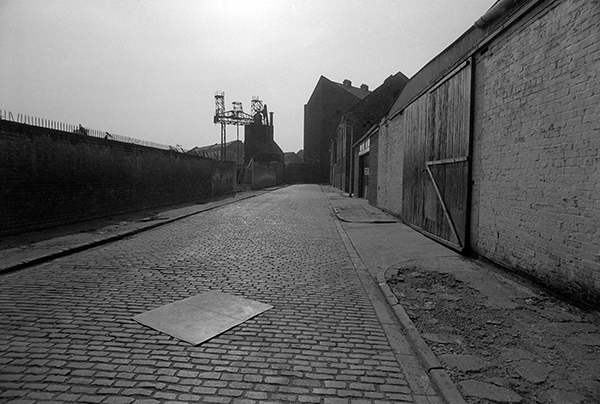
It’s hard to see now exactly the location of this picture, which on my contact sheet it labelled Foredyke Path, thought it should be simple given that there are three bridges shown.
I think the framing arch is a bridge under the disused Hull to Hornsea line, the distant bridge and embankment are the Hull Docks line, still in use, but can’t work out why there is a footbridge, apparently on the line of the path, which I think followed the Foredyke Stream drainage ditch, culverted a few years earlier and now part of the Hornsea Cycle Route which forks off around here. Other rail lines in the area were the branch to Withernsea and some sidings to mills which ended close to Cleveland St.
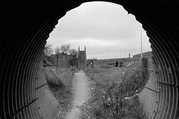
84-4d-12: Foredyke Path and railway bridges, 1984 – East Hull
2nd September 2017
Another visit to Queen’s Terrace in 1984. Number 1 and 3 Queen’s terrace still appear possibly to be occupied, though the off-licence had I think closed for good, and the sheet of ply lying across the doorway at right suggests this was no longer in use.
This was one of many small shops which had served what had been a densely occupied area of working class housing. Some of the area had been cleared following war-time bombing but much still remained until the council demolitions. There are still some shops on the opposite side of Sculcoates Lane, but others have been converted to private houses.
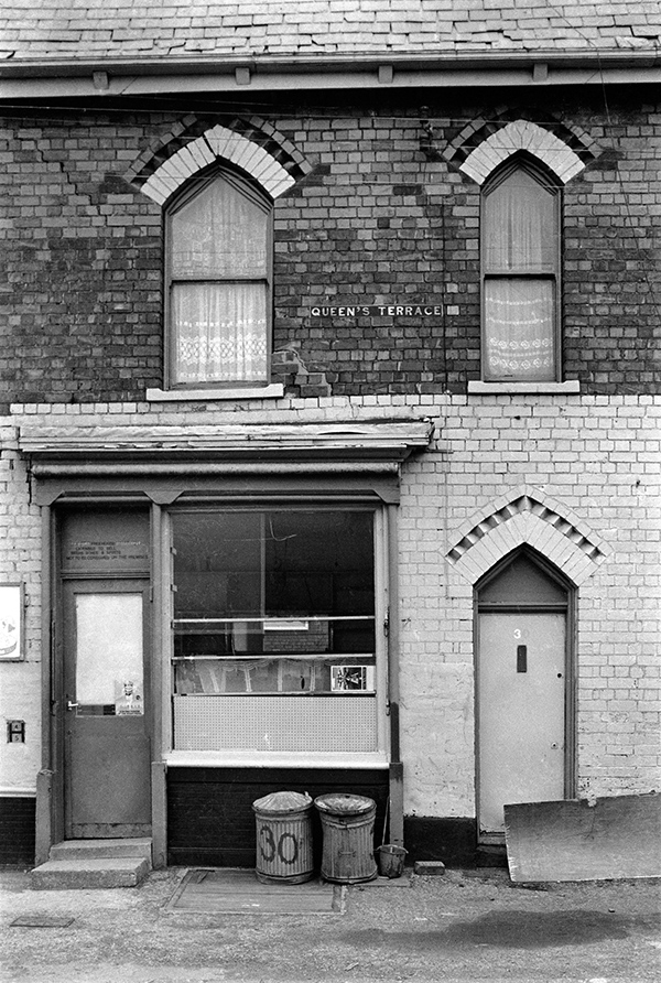
84-4d-65: Queen’s Terrace, Sculcoates Lane, 1984 – Beverley Rd
3rd September 2017
Another view of what I think from the brickwork is probably again Queen’s Terrace, but possibly another street in the same area, awaiting demolition in April 1984. One house appears still occupied, with net curtains at its windows while the rest of the terrace has doors and windows blocked with corrugated iron to prevent squatting. The one remaining door has the number 1 on it, but may have lost another digit.
Looking at existing terrace rows in the area and elsewhere in Hull you can see the various different treatments of the brickwork which mark the different streets or parts of streets. The arch above each of these doors and windows required ore than 20 bricks to be cut to shape and the windows needed specially shaped glass panes, all of which must have added considerably to the labour of construction. This part of the street appears to have been re-roofed and I suspect would originally have been slate.
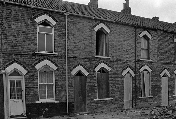
84-4d-63: Queen’s Terrace, Sculcoates Lane, 1984 – Beverley Rd
4th September 2017
There are still some pipes which cross Wincolmlee a few yards north of where I took this picture but this section of the wall and the bridge across from Holmes Halls Tanners to their wharf, as well as their buildings on the right have gone, replaced by some parking space and featureless modern sheds or cladding on older buildings and a used car sales yard. But the building with the chimney and much of its wall is still there, as this is the former Sculcoates Goods Station, also Grade II listed.
Further in the distance the listed Wilmington Swing Railway bridge survives, and now in rather better condition. Rix’s oil tanks have grown and what was then Pauls Agricultural Products silo – now Maizecor – on Wincolmlee is still visible.
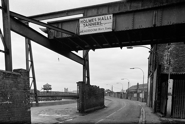
84-4d-66: Holmes Halls Tanners and River Hull, Wincolmlee, 1984 – River Hull
5th September 2017
In my book ‘Still Occupied’ this was wrongly identified as Morley St, but it is actually Glass House Row, further south off Cleveland St. The buildings on the right side of the street can still be identified, and closer inspection shows that some of the windows have been altered from their position when I took the picture. The industrial structure and the large building at the end of the street are now longer there, but the more distant buildings are still recognisable, as the large block next to the Bankside Cafe at 330-338 Wincolmlee.
According to the informative Wikipedia article on Wilmington, Glass House Row was named for the short-lived Hull Glass Company, set up in 1846 but which had failed by 1850. Later on the street were the Anglo-American mill (1879-80) and the Bon Accord Mill (1895), both apparently oil mills set up by brothers John and James Stephenson which later become part of BOCMM, who stopped milling at both in 1929-30, though Bon Accord went back into service for a couple of wartime years, ending in 1942.
84-4e-03: Glass House Row, 1984 – River Hull
6th September 2017
Teal & Mackrill Ltd are still in business on Lockwood Street, famed for their specialist marine grade varnishes, topcoats, undercoats, primers, anti-fouling and bilge paint. The company was established by Arthur Teal and Mr Harold Mackrill in 1908 and became a limited company in 1913. Still an independent family run company it has around 75 employees and makes around 1.5 million litres of paint a year, mainly for marine and agricultural use, including many specialist paints.
Paint manufacture was a major industry in Hull, with some major brands having factories close to the River Hull, though I think all have now moved away or gone out of business, while this specialist firm remains.
Both the paint on the nameboard and on the side of the building at right seems not to be the best advertisement for their products. Only the taller building at extreme left remains, the rest of the building having been replaced with a doubtless more practical but rather blank metal-clad large shed, its blue paintwork in excellent condition.
Somewhere on the buildings – I’ve only seen pictures – is a large mural originally commissioned for the 1949 Hull Industrial and Trades Exhibition by Patricia Mackrill who had just graduated from Manchester Art School, which was displayed in Hull City Hall.
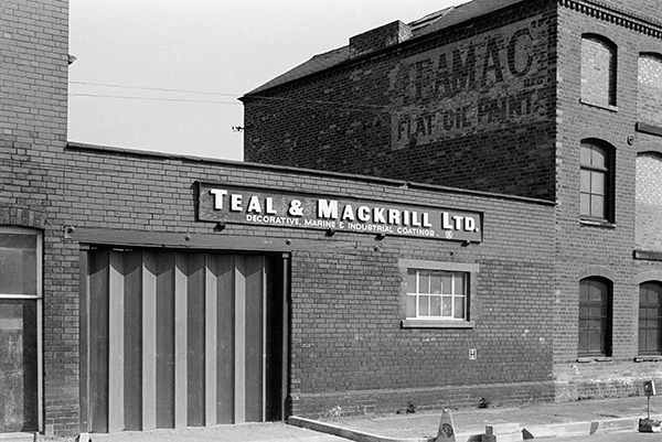
84-4e-13: Teal & Mackrill Ltd, Lockwood St, 1984 – River Hull
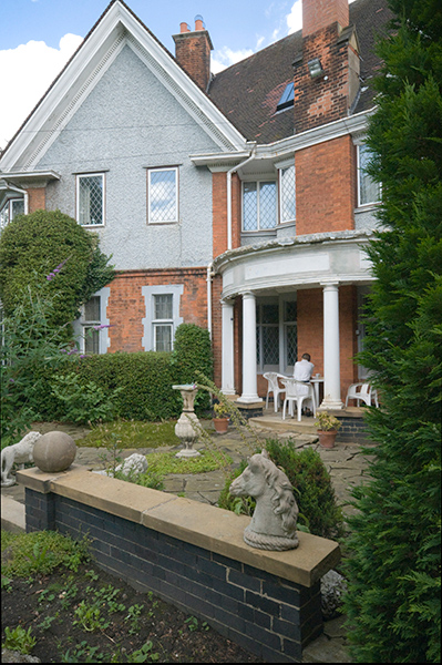
The loggia at the rear of West Garth, Newland Park, Hull
One of my late friends in Hull was a member of the Mackrill family, though I think with no involvement in the paint business. I knew Ian first in London, where after a legal career he became a psychotherapist but late in his life he bought another home in Newland Park, Hull and after a few years moved back into a large house there, West Garth, where he had lived for some years as a child. One of the finer examples of Arts & Crafts houses in Hull, he was unfortunately unsuccessful in getting it listed despite carrying out considerable work to restore it to its original state. It does get a brief mention in Pevsner’s volume on Hull. I and more often my wife stayed with him there on a number of visits to Hull in the 2000s.
7th September 2017
Extensive drainage is needed of land all over the catchment of the River Hull, much of which is close or below the level of the river at high tides, full of carrs, waterlogged areas often covered with trees such as alder and willow, and ings or water meadows and marshes. An extensive system of drainage developed over hundreds of years with the first recorded dyke being the Eschedike linking the Abbey at Meaux to the River Hull, built both for drainage and navigation in 1160-82. Later more drains were built discharging excess water into the River Hull or Humber at low tides, and one of the larger of these was the ‘Barmy’ drain, built following the passage of the Beverlev and Barmston Drainage Act in 1798.
Despite all the work done over the centuries – including building the tidal barrier to stop tidal flooding, Hull is still prey to flooding, and large areas suffered in the 2007 floods caused by torrential rain which led to 17,000 homes being affected, with 10,000 people having to be evacuated.
For many years the drain was a water playground for the children of Sculcoates, many of whom learnt to swim in it, though I think this is very much discouraged now, perhaps because over a hundred people are said to have drowned in it, some committing suicide. It is supposedly home to the mythical ‘Beast of Barmston’, half man and half dog.
I don’t know anything about this mural, which includes Mr Winn’s Post Office & General Stores and the Outreach Arms, but it was at the rear of buildings on Northumberland Ave, and the pitched gable end and roof at right is I think the rear of Trafalgar Motors, while the larger roof in front is the back of what is now Ralph’s Autos. The picture is taken from the footpath beside the drain which runs along what used to be the Hull & Barnsley line into its Cannon St terminus.
The town shown on the mural looks nothing like any part of Hull I know, and unlike Hull is overlooked by distant hills. The canal scene is also rather inappropriate for what is a drainage ditch and was never I think used for navigation.
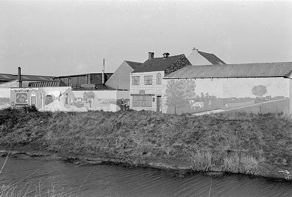
84-4e-16: Beverley & Barmston Drain, 1984 – Beverley Rd
You can see the new pictures added each day at Hull Photos, and I post them with the short comments above on Facebook.
Comments and corrections to captions are welcome here or on Facebook.
______________________________________________________
There are no adverts on this site and it receives no sponsorship, and I like to keep it that way. But it does take a considerable amount of my time and thought, and if you enjoy reading it, a small donation – perhaps the cost of a beer – would be appreciated.
My London Diary : Buildings of London : River Lea/Lee Valley : London’s Industrial Heritage
All photographs on this and my other sites, unless otherwise stated, are taken by and copyright of Peter Marshall, and are available for reproduction or can be bought as prints.