Hull Photos: 4/5/17-10/5/17

4th May 2017

When I took this picture it struck me as being a statement about the state of Hull’s fishing industry, once so important but largely brought to an end by the Cod Wars. But the final settlement in 1976 was largely a matter of the Cold War rather than fish that settled Hull’s demise, with Iceland threatening to withdraw from NATO over the issue. This would severely have restricted NATO surface and submarine movements in the North Atlantic, between Iceland and Greenland and also between Iceland and the UK, and would have allowed Soviet submarines access to these waters.

Without these considerations a settlement would surely have been reached that kept the deep-sea fishing industry alive, if at a lower level than before. The British government under James Callahan sacrificed our deep sea fishing to the military hawks. Hull became a victim of the Cold War as well as World War II.

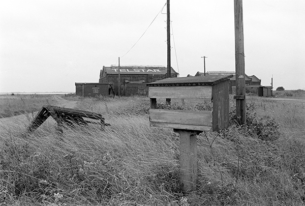
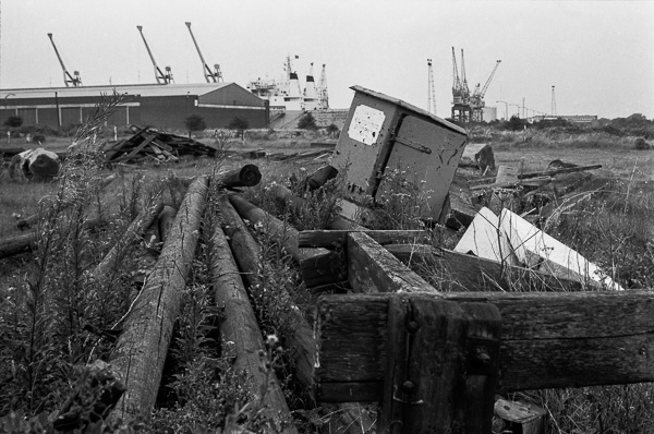
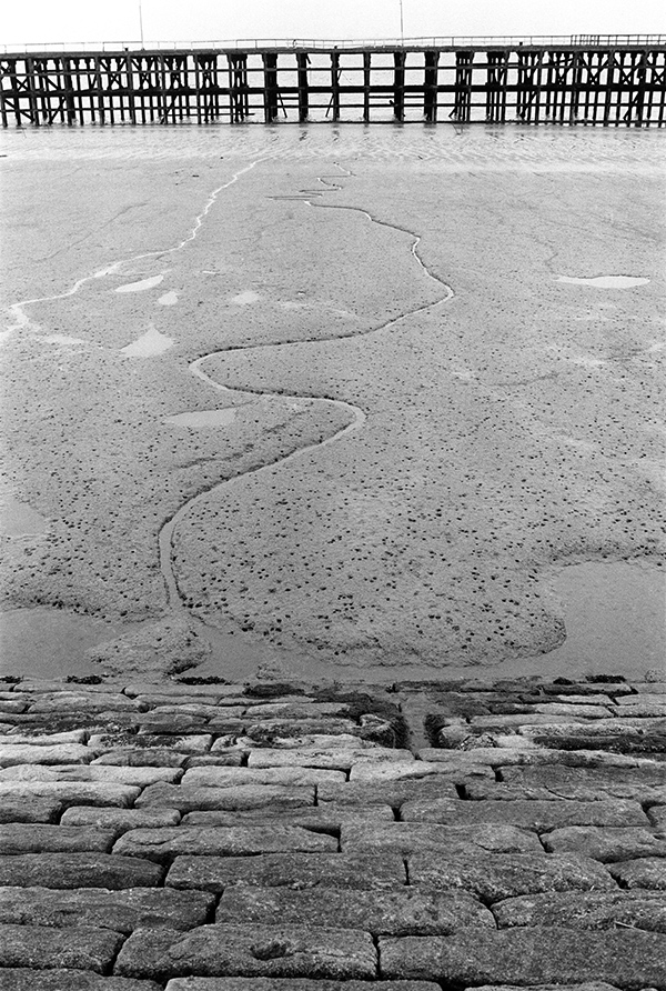
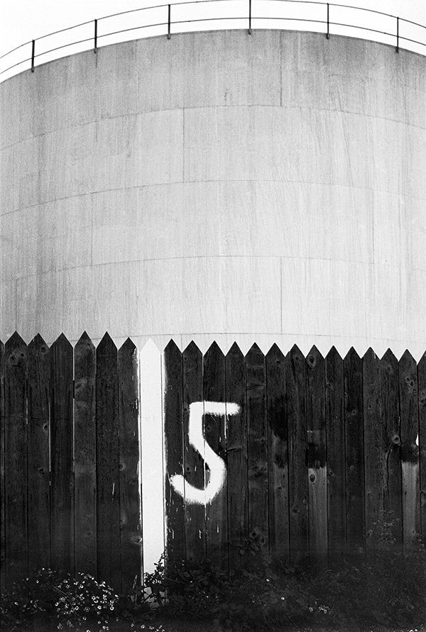
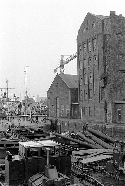
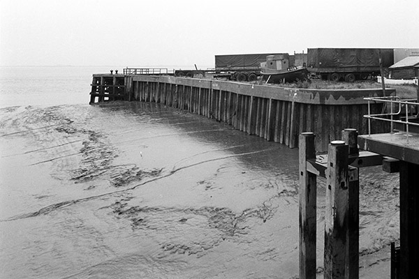
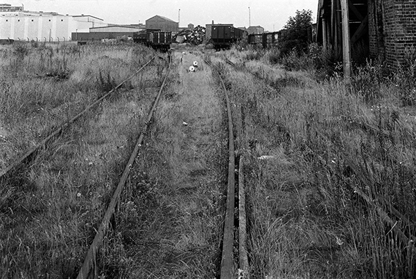
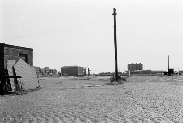
The picture was I think taken from the near the top of the steps up to the footpath which still leads across the roof of some of Albert dock sheds between the dock and the Humber, still one of Hull’s most interesting experiences. Around 20 years after I took this picture it became a part of the Trans Pennine Trail and European walking route E8. There are 3 blocks of barrel-vaulted sheds, each with 7 vaults alongside the Humber, designated from the east as A, B and presumably C. The footpath comes up from beside the entrance lock to the east end of block B, then goes along the top of this and block C, at the end of which steps lead down and the path continues beside the Humber. These boxes were I think in the space between blocks A and B – with a little of block B visible at top right. There is then a short drop down which hides the roadway to the narrow quay with the tee-head mooring bollard (numbered 205) and the Humber beyond.


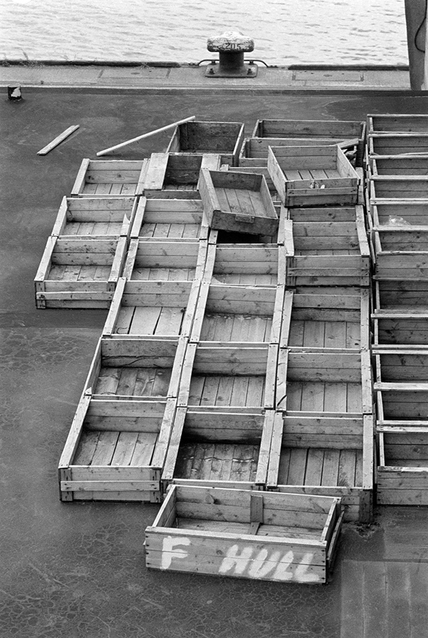
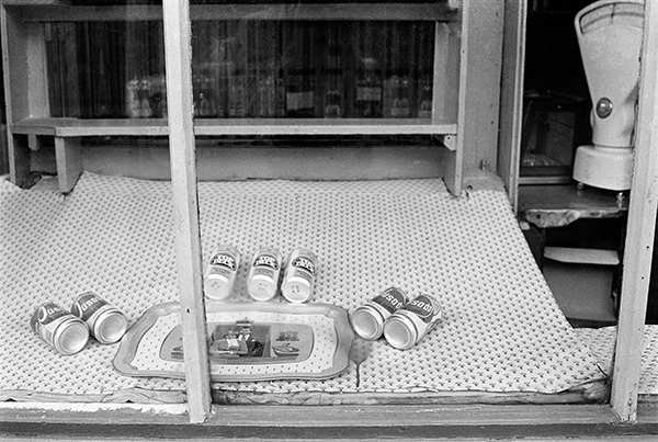
32q21: Empty boxes, Albert Dock, 1982 – Docks

5th May 2017

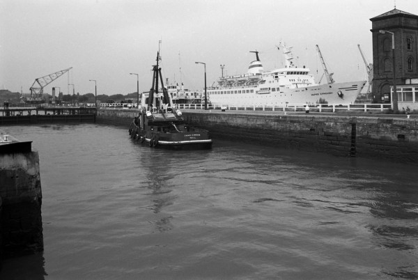
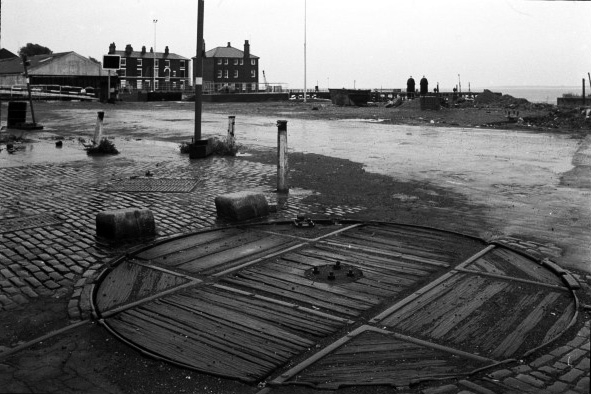
Taken through the girders of the steel swing bridge which took the road and a single rail track across the entrance lock to ALbert Dock. This bridge was across the centre of the lock was later replaced by a much less sturdy structure taking just a footpath across close to the other gate. The footpath also runs across the inside dock gate as an alternative route.

Albert dock was full of vessels but there was very little movement in or out of the dock and Hull’s fishing fleet was largely idle. Fish were I think still being landed, but now by Icelandic vessels.


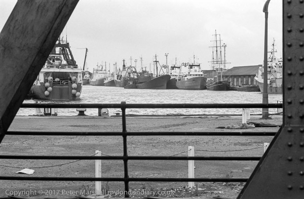
32q11: Albert Dock from swing bridge, 1982 – Docks

6th May 2017

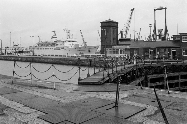
Humber Dock is now Hull Marina, and crowded with yachts. The distinctive tall 3-bay No.13 warehouses on Railway Dock are still there along with some of the city centre buildings on the horizon, but the rest have long gone.

Another small ship is moored beyond the Coquet Mouth but few details are visible, and this side of the dock is otherwise empty. The Coquet Mouth is a small (171 Gros tons, 30.84m × 7.85m) Grab Hopper Dredger, presumably there to dredge the DOck for use as the marina. She was built in 1955 by W.J. Yarwood & Sons Ltd at Northwich and a few years ago was still working at Goole.

She replaced an earlier dredger of the same name which was sunk by a mine in 1940, which got its name from the River Coquet, which flows into the North Sea at Amble, Northumberland. The ship was on sale in 2012 for £ 54,995 described as a Barge Mooring Vessel for possible conversion to a houseboat, but is I think still around, with some fairly recent images showing her in dock at Hull and on the Humber.


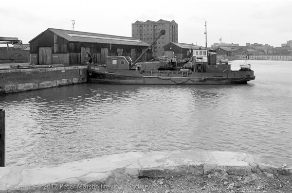
32q13: Humber Dock from Wellington St, 1982 – Docks

7th May 2017

Inge, moored here in Albert Dock in 1982 had a small taste of fame when she was hired to make a Christmas episode of ‘Only Fools and Horses’, ‘To Hull and Back’ in 1985, in which Del and Rodney go in it from Hull to Holland with experienced sailor Albert – whose experience turns out to have been only in the engine room rather than on the bridge – to buy diamonds with counterfeit cash to smuggle back to Hull, getting lost in the North Sea on both outward and return journeys.

Coming back they follow the Hull – Zebrugge roll on – roll off ferry MV Norland but at first this takes them to Zeebrugge rather than Hull – so they wait and follow it home. I rather suspect the Inge would not have been capable of keeping the ferry in sight for long with the ferry’s maximum speed of 19 knots.

Inge was owned by Humber Divers and used for survey work both in 1985 and when I took this picture in 1982. The divers used it to explore a number of wrecks along the east coast – particularly World War II aircraft – where a smaller vessel than their main one was adequate. The company went in to voluntary liquidation in the late 1970s.

At the right is the Albert dock entrance.


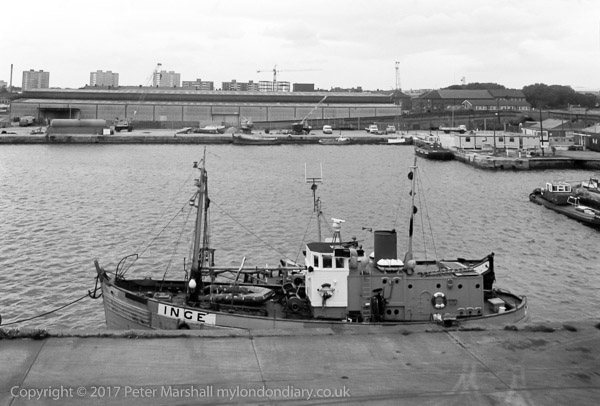
32q31: Inge moored in Albert Dock, 1982 – Docks

8th May 2017

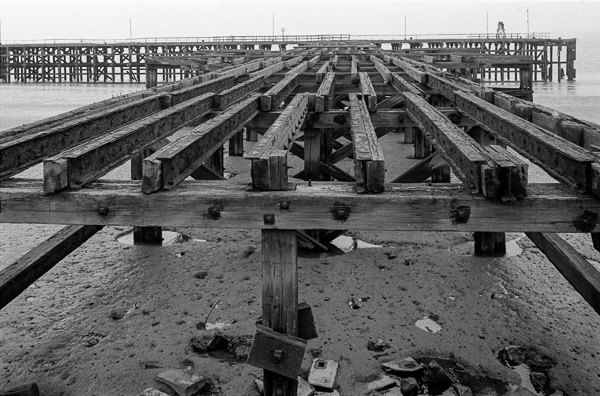
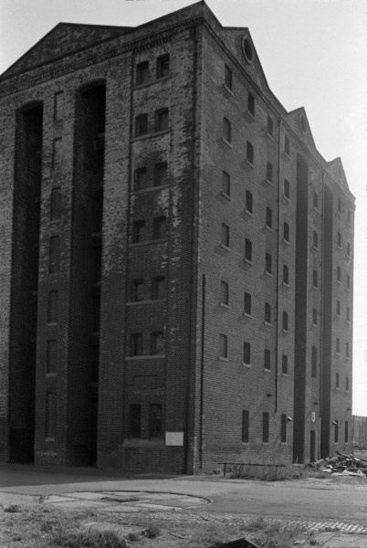
The public footpath, now part of the Trans Pennine Trail, is on the extreme left of the picture behind the fence and the view is along most of the three blocks each of 7 barrel vaults beside the Humber, though it gets hard to distinguish the roofs in the distance. The curve of the Humber shore with Hull’s Eastern Docks and then the cooling towers at Saltend and on towards Spurn still looks similar today, though with rather fewer cranes.


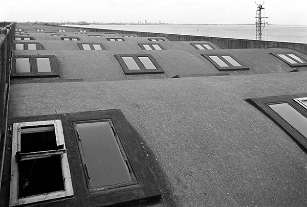
32q42: Public footpath across roofs of dockside buildings, Albert Dock, 1982 – Docks

9th May 2017

From the public footpath on top of the dockside sheds between Albert Dock and the Humber I could see a small vessel moored in the river, its anchor chain clearly visible in a large image, but its name just too indistinct to make out. It appears to be a coastal tanker, similar to those often seen in the River Hull and making their way up the Humber towards Goole. Although static, he ship has a slight wake as the tide flows out past it, and its outline disturbs the otherwise careful near-symmetry of the composition.

The opposite bank appears to be fairly empty, except for trees, though in the distant haze above the bank above the bridge of the ship I can see the towers of oil refineries, presumably the Lindsey refinery at North Killingholme and its neighbouring Humber refinery at South Killingholme, though these are invisble on the small web image. To the right is a tall chimney and further right still a long line of buildings.


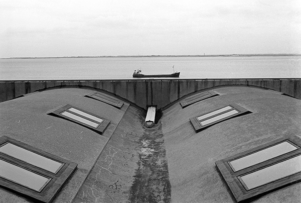
32q66: Dockside shed roofs and the Humber, Albert Dock, 1982 – Docks

10th May 2017

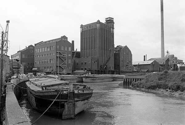
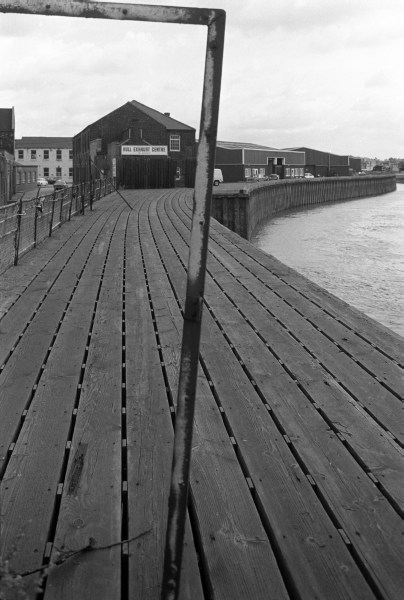
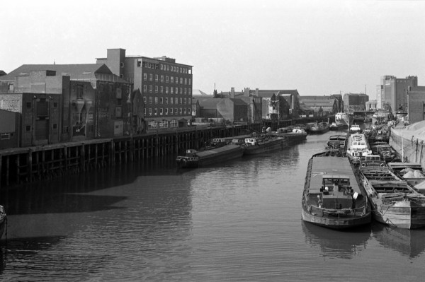
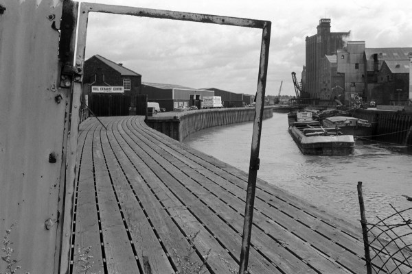
A picture from a virtually identical viewpoint to one posted earlier from another walk along Bankside, taken through the gate to a wharf on the River Hull at Hull Exhaust Centre but with a landscape rather than a portrait view which gives a very different picture. Included at the right of this image are a number of moored barges, the Croda Isis Oil Mill and closer buildings which I think are a part of the Reckitt’s ultramarine works, established here in 1884.

One of the barges clearly has the name ‘TIT’ and the number 52 on its stern, and the closest vessel is possibly ‘JOLLY ?’. At the left of the picture the sheds on the west bank are clearly more modern, and beyond the Exhaust Centre is a van for Firdale Foods, a Boston, Lincs based meat and poultry company which was dissolved in 2000.

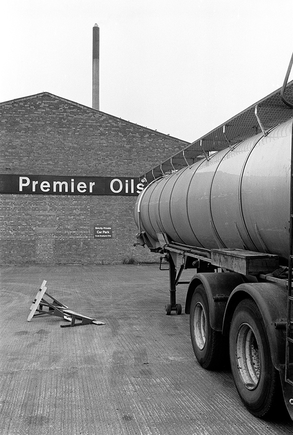
The Grade II listed Isis Oil Mill in Morley St were built in 1912 for Wray, Sanderson & Co (architects Gelder & Kitchen.) In 1947 the company became part of Premier Oil and Cake Mills Ltd and was acquired by Croda in 1967. In 1985 it was bought by Cargill Ltd and is still in business crushing rape to make rape seed oil and other products.


32r15: Hull Exhaust Centre, River Hull and Croda Isis Mill from Bankside, 1982 – River Hull


You can see the new pictures added each day at Hull Photos, and I post them with the short comments above on Facebook.
Comments and corrections to captions are welcome here or on Facebook.
Continue reading Hull Photos: 4/5/17-10/5/17

Hull Photos: 27/4/17-3/5/17

27th April 2017

There is little trace of the various buildings that were a part of Victoria dock now, with I think just the winding house of the slipway surviving, along with the slipway itself and the Outer Basin and Half Tide Basin, and the swing bridge from this across the entrance to the main Victoria Dock.

The two-storey brick building in this picture and the shed attached to it are some of the buildings which haven’t survived, and it isn’t easy now to know exactly where they were, but I was making my way east though the dock from the Half Tide Basin where I took the previous picture, but like all photographers I tended to wander somewhat.

Lister Blackstone were active from 1937, when Blackstone was taken over by Lister until 1965 when they were taken over by the Hawker Group. What this and the other engines etc were doing in this yard on Victoria Dock can only be a subject of conjecture on my part. It looks to an untrained eye rather like a Lister JP3 engine which were made in the immediate pre- and post-war era for both industrial and marine use, or perhaps a larger version of this. Many such engines are still working and can sell for a few thousand pounds.


32p42: Victoria Dock, 1982 – Docks

28th April 2017

This view looks roughly east from close to the boundary of Victoria Dock and the distant buildings are I think the sheds around the half-tide basin and dock with, between the first two buildings the two pylons carrying the docks name between them at the entrance. In the far distance towards the right, at the end of the line of telephone poles is Hull’s tidal barrier, and in front of it a chimney, which could be one of the few surviving features in the redeveloped area, the engine house of the slipway. The engine itself is now on display beside the Marina on Humber Dock St.

By the time I took this picture in 1982, Victoria Dock was already filled in, and this Attendant’s Office where drivers were instructed to report was boarded up and redundant.


32p43: Attendant’s Office for Filling of Victoria Dock, 1982 – Docks

29th April 2017

There were still a few men working in what appeared to be a graveyard for boats at the east end of Victoria Dock, in an area which had once been part of Earle’s Shipbuilding & Engineering Yard.

Charles and William Earle set up in business together in 1845 as millwrights, founders and general smiths but realised the potential of iron hulled ships and in 1853 built their first vessel. After a disastrous fire in 1861 they moved to a 26 acre site to the east of the new Victoria Dock, later adding another 47 acres and were soon the second largest shipbuilder in England, close behind the Humber Ironworks and Shipbuilding Co (formerly Samuelson’s) based at Sammy’s Point. In the 19th century it built ships for the Chilean, Japanese, Russian and Greek navies – and eventually several cruisers for the Royal Navy, as well as cargo vessels, ferries and of course trawlers. The yard went bust in 1900 and after a year was bought by another Hull company, the the Wilson Line, then the largest private shipowners in the world (but bought in 1916 by Ellerman to become Ellerman’s Wilson Line.) The yard closed in 1932, with much of its equipment going to the Kowloon ship yard in Hong Kong.

The yard was one of the earliest to build steel ships and also pioneered the use of triple-expansion engines, but an earlier attempt at innovation with a cabin on gimbals to combat sea-sickness built for Henry Bessemer was a disaster. They built the Russian Imperial yacht and one of their final orders was a flat-pack steamer for use on Lake Titicaca which remained in service there for over 50 years. They had in 1904 built the SS Inca in similar kit form which was assembled at Lake Titicaca, 12,507 ft above sea level, in 1905.


32p44 Site of Earle’s Shipbuilidng & Engineering works, Victoria Dock, 1982 – Docks

30th April 2017

Joynson & Son, Scale and Slicing machine specialists, established in 1892 were at 75 Mytongate, on the north side of the street in a row of shops between the Rampant Horse Inn and Thomas Borthwick and Sons Ltd, meat exporters on the corner of Vicar Lane. Joynsons are still in business, now at 45 Anlaby Rd, as catering equipment specialists, providing food service solutions & catering disposables.

The only building in this section of the street to escape demolition was the former Mytongate telephone exchange and headquarters of the Hull Corporation Telephone Department from 1914-64, at No.65 – though the street has since changed its name to Castle St, and is considerably wider, part of a continuing Highways Agency scheme to turn much of the city into the near-motorway A63, with a giant swathe of the Old Town lost to tarmac and wasteland, still largely awaiting recovery – or perhaps to be submerged by further road schemes.

Fly posters on the boarded up windows include those for ‘Rock Stateside’ at the Live Wire Disco, events at the City Hall and Hull Tower and a poster protesting against the first visit to Britain of President Reagan in June 1982 with the message ‘Neither Washington Nor Moscow But International Socialism’.

Hull demolition contractors D J Broady, ‘Space-Made’ went into administration in 2011. Together with Sam Allon they were responsible for demolishing many of Hull’s most notable buildings. The wife of one of Hull’s most prominent Aldermen was said to be a major shareholder in D J Broady.


32p52: Joynson & Son, 75 Mytongate, 1982 – Old Town

1st May 2017

Telstar was I think TELSTAR CARAVANS LIMITED, a company who made caravans and whose registered office had the address Victoria Dock, Hull and went into liquidation in 1978-80. I’m not sure of its exact location in the dock but think it must have been to the west of the Half-Tide basin which I photographed a few frames later, and is fairly close to the bank of the Humber, perhaps near the slipway in what was once the LNER dock yard.

Probably the company was named after the 1962 instrumental hit written and produced by Joe Meek for the Tornados, which got it’s name from the first communications satellite to transmit TV across the Atlantic, Telstar 1, also launched in 1962.


32p53: Telstar, Victoria Docks, 1982 – Docks

2nd May 2017

Burnett House was built as the Queen’s Hotel at 82 Mytongate, and in 1875 the frontage was rebuilt with the Britannia consoles and distinctive window surrounds and the hotel renamed as the Britannia Hotel. It closed as a hotel in 1913 and became the offices of shipping agents Stockwell & Co. Ltd. After the second war it was occupied by shipping agents Burnett & Co (Newcastle) Ltd and renamed Burnett House, though retaining the name Britannia Hotel on its east wall. It had been empty for some years when I took this picture stood empty and derelict for years on Mytongate.

Mytongate was around this time drastically widened as the A63 and renamed as Castle St, with Burnett House becoming 82-3 Castle St The frontage was finally renovated in 2006 back to its 1875 condition and advertised without success as office space. Later it was converted to seven flats and ground floor retail premises around 2015 when it was finally let. The ground floor is now occupied by an estate agents and property letting company. Some of the delay has been attributed to incompetence by the agency set up to market Hull Council properties, Hull Forward, which was disbanded in 2010.


32p66: Burnett House, Mytongate (Castle St), 1982 – Old Town

3rd May 2017

These sheds were either along the dockside either close to the entrance lock to Albert Dock, and may have been taken from the south end of the substantial swing bridge which then took a roadway and the public footpath across the lock, or possibly on Humber Dock, where I made my next exposure.

There were warning lights and gates which closed the entrances to the bridge before it swung, and large notices prohibiting pedestrians or vehicles from being on the bridge while it was being operated. But on one occasion the bridge operators failed to notice that my wife was still walking across it with our younger son and took her for a ride.

The recent Scale St footbridge across the River Hull was designed and built as the first such footbridge in England that allowed foot passengers to be on it while it is operated, and is opened briefly every Saturday, at a time which depends on the tide for those who wish to take a short ride.


32q12: Dockside sheds, Albert Dock or Humber Dock, 1982 – Docks


You can see the new pictures added each day at Hull Photos, and I post them with the short comments above on Facebook.
Comments and corrections to captions are welcome here or on Facebook.
Continue reading Hull Photos: 27/4/17-3/5/17

Hull Photos: 20/4/17-26/4/17

20th April 2017

Hawthorn was a general cargo ship, gross tonnage 1197 tons, built by D.W.Kremer & Sohn GmbH & Co. in Elmshorn, Germany in 1967, and had various names and owners. She began as ORTRUD MÜLLER, and was then HUNNAU and FRANCINAPLEIN before coming to Liverpool owners in 1977 who named her HAWTHORN. In 1992 she became BLACKBIRD, and since then has been SMARAGD and GULF TRADER, and was last heard of as the LADY AGNES, registered in Kingstown (Saint Vincent and the Grenadines and not Hull), sailing under a Tanzanian flag and leaving Port-de-Paix in Haïti a few days ago.

My picture shows here moored in Alexandra Dock, Hull. The cranes are long gone too.


32p22: Hawthorn in Alexandra Dock, 1982 – Docks

21st April 2017

Taken somewhere on the walk from Alexandra Dock to King George V Dock, where you can see ships moored in the distance. It may be from where the path detoured slightly to cross the Holderness Drain which flows into the Humber here at Marfleet.

Drainage of the low-lying Hull valley has always been a problem, with flooding both from higher land to the north and tidal salt water from the Humber. Flood defences were certainly being built along the Hull and the Humber by the early 14th century, with simple sluices to allow water to flow into the rivers at lower tide levels. The sixteenth century saw the start of new drainage schemes, and a drain taking water from the north to the Humber at Marfleet was first proposed in 1671, but not dug. Just over a hundred years later a new plan was granted approval by Parliament, but with drainage into the Hull at Stoneferry, as Hull’s shipping owners argued the flow of this water was needed to stop Humber mud silting up the Old Harbour on the River Hull. It was only in 1832 that permission was obtained for an outlet at Marfleet.

In 1885 the Alexandra Dock was opened immediately to the west of the Holderness drain, and water was then pumped from the drain to raise its level and stop the mud-heavy Humber water entering the dock around each high tide. The King George V dock immediately to the east, opened in 1913 and used more water pumped from the drain for the same reason.


32p26: King George V Dock, 1982 – Docks

22nd April 2017

Victoria Dock had been closed for a dozen years, but there were still scattered remains of its past, including odd piles of sand and gravel and a few boats which had been left stranded on the dockside, some in various states of scrappage, producing at times a rather surreal landscape.

The picture was taken in the eastern part of the dock estate, and was a part of the area that until 1932 was one of Hull’s largest ship-building yards, Earle’s Shipbuilding & Engineering Yard.


32p31: Victoria Dock, 1982 – Docks

and


32p46: Victoria Dock, 1982 – Docks

23 April 2017

A long disused jetty leading out to the long West Wharf pier in the Humber off the west end of Alexandra Dock. The pier had a minimum water depth of 18ft.

This was the westernmost of three jetties leading to the wharf, and the only one without a railway line, presumably only used by workers on foot and lorries. The remains of the pier and jetties were still visible until the redevelopment of the site for Green Port Hull.


32p33: Western Jetty to West Wharf pier, Alexandra Dock, 1982 – Docks

24th April 2017

The Humber mud seems to stretch out from the river wall almost to the flimsy-looking wooden structure of the West Wharf around 400 ft away, and it seems unlikely that moorings there would still have enjoyed the 18ft of water at low tide which the Wharf had when built in 1911.


32p34: West Wharf, Alexandra Dock, Humber, 1982 – Docks

25th April 2017

Until recently a public right of way ran across the lock gate here, and led on beside the Humber to King George V Dock and beyond, coming to a disappointing dead end in the middle of nowhere.

This path around the south of Alexandra Dock was diverted in 2012 as a part of the development to allow Siemens to build wind turbine blades here and enable them to be transported more readily to offshore locations.

All the dockside buildings have since been demolished, including the tall posts at right which carry a sign across between them at their top, with the name Alexandra Dock, designed to be clearly visible to those navigating the Humber. There was a similar structure at the entrance to Victoria Dock.


32p36: Alexandra Docks entrance lock, 1982 – Docks

26th April 2017

Taken from the dockside at the north of the Half Tide Basin, close to where a swing bridge led into the main Victoria Dock, already filled in when I made this picture. The two gates lead into the Outer Basin and on to the Humber. The wider of the two – on the left of picture – was 100ft wide and the narrower was used for barges. The Half Tide Basin enabled vessels to enter from the Humber at any time from when the tide was halfway in to when it was halfway out, hence the name, thus greatly increasing the time available for shipping into and out of the dock.

The main entrance had only a single gate and would be kept open while the tide was above half level, then closed to keep the water at half-tide level. Smaller vessels could use the narrower lock at right when the tide was out so long as the outer basin had enough water to float the boat, as the smaller size incurred less loss of water.

As can be seen, the dock was open to the Humber and had silted up considerably by 1982. There were plans to develop the dock as a marina, but these proved too expensive and the developers were allowed to permanently block the entrances. Virtually the only things that has survived from the working dock were the dock walls and the bridge across the entrance from this basin to the now completely filled in main dock to one side of me as I made this picture.

The dock now acts as drainage for Victoria Dock Estate which was developed from 1988; water is stored there and then discharged through small sluice gates when the tide is low. Unfortunately these gates are now silted up in the outer basin and pumps are needed to protect the estate from flooding, as this is cheaper than dredging. It is being used this year as the venue for a series of four performances in Hull’s year as UK City of Culture, ‘Flood‘, by theatre company Slung Low who are based in Leeds rather than Hull.

Floods of course continue to be a significant threat in Hull, with major floods in June 2007 and several others since, most recently in November 2016 when large areas of the city were again affected. Mostly these are now due to heavy rain across the area, though a tidal surge caused flooding in 2013. The tidal barrier is said to have saved 19,000 homes from flooding then, but it was a close call, with the water reaching around 8 inches from its top. More than 90% of the city is said to be below high tide level.


32p41: Half Tide Basin and entrance locks, Victoria Dock, 1982 – Docks


You can see the new pictures added each day at Hull Photos, and I post them with the short comments above on Facebook.
Comments and corrections to captions are welcome here or on Facebook.
Continue reading Hull Photos: 20/4/17-26/4/17

Hull Photos: 13/4/17-19/4/17

Pictures added to my Hull photos web site from 13th-19th April 2017

13th April 2017

Although Alexandra Dock was still in use, the West Wharf on the Humber bank was derelict, its railway lines disconnected and much of the decking gone. Further west the whole area around Victoria Dock was a desolate wasteland and it was hard to know where I was, the map I had providing few clues.

Victoria Dock had been opened in 1850, and two large timber ponds were added over the next 15 years. These were filled in and became timber yards with rail sidings by the 1950s. The dock closed in 1970, but development of the site with housing only began in 1987.

Alexandra Dock was built on land reclaimed from the Humber in 1881-5 and extended in 1899. West Wharf pier was added in 1911 and was 1,350 ft long, and had a minimum depth of water of 18ft. The dock was closed in 1982, but there were still a few ships in it when I took these pictures in August of that year, and some sand and gravel was still handled there in the 1990s. It looked as if the West Wharf jetty in the Humber had closed rather earlier.

The West Wharf was replaced by a riverside container terminal around 2010, which then became part of Green Port Hull, a development for Siemens to handle wind turbines.

The river side of the West Wharf was the original location of Hull’s famous ‘Dead Bod’ graffiti made in the 1960s by Captain Len (Pongo) Rood. This was removed into storage when the container terminal was being built and was exhibited in the bar of the new Humber St gallery as a part of the 2017 City of Culture.


32n44: Disused Jetty, Alexandra Dock West Wharf, 1982 – Docks

14th April 2017

Another view of the entrance lock to Alexandra Dock, with the Hull tug Trawlerman moored in it, taken from the public footpath which crossed the lock gate here. In an arm of the dock to its right is the ship MAPÈß EPMOAOBA – the Maria Yermolova, a Russian cruise liner built for the Murmansk Shipping Company in 1974 at the Kraljevica shipyard named after Marshall Tito who worked there before the war. It was the first of eight similar ships built there under an order made by Leonid Brezhnev after a brotherly plea from Tito to save the shipyard. They were luxury ships for 206 cruise passengers with air conditioning in all cabins.

Behind the cruise liner is another vessel, but I can’t make out any details of it.


32n53: Entrance lock, Alexandra Dock, 1982 – Docks

15th April 2017

I took only three pictures in what was quite a long walk back from Stoneferry Bridge to my parents-in-law’s home on Loveridge Ave, around 2.4 rather dreary miles, though it seemed longer. Probably I was tired as I’d walked some busy and dusty roads on an August afternoon. I think nothing in those 3 pictures from 1982 remains. Only the second I took appears in my book and is the image I’m adding to the site today.

Stoneferry Bridge, a swing bridge across the River Hull built in 1905 to replace a ferry was replaced by two bascule bridges – one for each carriageway – in 1989-90. It’s an image that I might post later, but haven’t yet scanned.

The Kingston factory with its lodge and prominent sign appears to have disappeared without trace, and I’m no longer sure exactly where it was. The weeds growing in the yard suggest it was no longer in use but it is perhaps surprising that this small building does not seem to have been retained as a feature in front of a modern development as it was something of a local landmark.

The final exposure was a too tightly framed view of Cedar Villas, a wood-boarded frontage that was already looking rather derelict. I think I took this as a note to come back later to make a better picture, but by the time I did it had gone.


32o26: Kingston factory and sign, Clough Rd, 1982 – Beverley Rd

16th April 2017

The ISIS Oil Mills in Morley St, built for Wray, Sanderson & Co but more recently a part of Croda, were designed by Hull architects Gelder & Kitchen and built in 1912 and are a remarkable ensemble, though I think only the silo was Grade II listed in 1994. It was acquired in 1985 from Croda by Cargill plc and is apparently still crushing rapeseed – up to 750 tonnes a day to produce around 320 tonnes of rape seed oil and 420 tonnes of rape meal used in animal feed etc.

The large chimney beyond is ‘Reckitt’s Chimney’, the tallest in Hull, built to discharge sulphur dioxide into the atmosphere at a height of 463 ft. Scandalously this acid rain producing discharge continued until the start of the current century, when finally a desulphurisation plant was added – and a few years later the works closed. Reckits’s sold the plant, which produced large quantities of synthetic ultramarine, used in various products including Reckitts Blue laundry whitener in 1994 to Yule Catto and it later became part of Holliday Pigments, and then Hunstman. They are still the largest producer of synthetic ultramarine in the world but it now comes from their more modern French plant.

The barges in the picture reflect the importance of the River Hull for transport to the industries along the river in the past. There is now very little river traffic, but some very busy roads. The name of the nearest barge is something of a mystery, appearing to contain the letters ‘OTMOT’ which I can’t make into anything I recognise, but moored in front of the silo is ‘Ringplover’.


32o35: River Hull, barges and ISIS Oil Mills, 1982 – River Hull

17th April 2017

Bulk tankers parked in yard off the Stoneferry Rd on part of the Croda site. Presumably these were used for the bulk delivery of rape seed oil to food manufacturers.


32o45: 13 April 2017 Croda Premier Oils, Stoneferry Rd/Maxwell St, 1982 – River Hull

18th April 2017

The riverside path led from Alexandra Dock to King George V Dock alongside the Humber with much of the route running alongside a wooden fence which screened off the docks. On the Humber side were several wharves including one where ferries to the continent berthed.

Over the fence were a number of tanks or various sizes, including a large one with the name ‘UNITED MOLASSES’. There web site says that their storage capacity for industrial and food products – molasses, vegetable oils and related products – here is now around 32.5 cubic metres, with tanks from 40 to 2,600 cubic metres.

The company was founded in 1911 and first registered as United Molasses in 1926. It built its first bulk tank in Hull at Victoria Dock in 1911, which received its first bulk shipment of 1,800 tonnes of molasses from the sailing barque Sunlight in 1912. The company was acquired by Tate & Lyle in 1964 and they sold it in 2010 and it is now the UM Group.


32p16: Bulk storage tank, King George V Dock, 1982 – Docks

19th April 2017

A shed next to the footpath across Alexandra Dock entrance carries a notice from the British Transport Docks Board warning persons using the public right of way in Alexandra Dock that trespassers on the dock estate will be prosecuted. The notice, probably long gone, is no longer needed as the footpath in the dock was closed in 2012 for the convenience of Siemens and their wind turbine building facility here.

The shed was close to the entrance lock on the east side, and the brick tower at right can be seen in some pictures next to the berthed Maria Yermolova. The lower building in front of it looks as if it might have been of the hydraulic power system that was widely used in Hull’s Docks.

All buildings in the area appear now to have been demolished.


32p21: Alexandra Dock, 1982 – Docks


You can see the new pictures added each day at Hull Photos, and I post them with the short comments above on Facebook.
Comments and corrections to captions are welcome here or on Facebook.
Continue reading Hull Photos: 13/4/17-19/4/17

Hull Photos: 6/4/17-12/4/17

A picture is added daily to ‘A View of Hull’, my Hull photos web site at http://www.hullphotos.co.uk/ and I also post them with these comments on Facebook.

6th April 2017


32m65: Princes Dock from Monument Bridge, 1982 – City Centre

The railings are still their, though now rather more smartly painted, but the dock bridge seen through them has gone. Many of the buildings around the dock are still there, along Princes Dock St, the rather dumpy warehouses on Castle St, their considerably more elegant counterparts at Railway Dock. The dockside sheds are long gone, and the white building near the right edge, The Earl De Gray pub, is under threat of demolition. Built as the Junction Dock Tavern in the 18th century (some say as early as 1720, other sources place it later) , and altered considerably in Victorian times it was Grade II listed in 1994.

The Earl de Grey was known to sailors around the world, serving their needs when they hit port for perhaps 180 years, described as “a seedy dive populated by drunken sailors and women of the night” and latterly by transvestites it closed around 2000. Four years later after an expensive face lift it opened again, but not for long, closing again the following year.

Earl de Grey and Ripon (later Marquis of Ripon) was installed Lord High Steward of Hull in 1863. He was a Liberal politician who was even born in Downing St (his father was PM at the time) and became one of Hulls two MPs in 1852 but both Hull MPs were unseated the following year because of widespread corruption in their election (though not by them.) He was then elected as MP for Huddersfield. Later he served for four years as Viceroy of India, and introduced a progressive bill in Parliament calling for great rights for native Indians – which Parliament rejected. He later became Leader of the House of Lords.

High Steward of Kingston upon Hull is a ceremonial title which Hull City Council has given occasionally to prominent people with some association to Hull since the sixteenth century. In the old days it included gifts of ale, and so the renaming of the pub was appropriate. Though the office was abolished in 1974, for some deranged reason it was revived in 2013 and awarded to Peter Mandelson of all people. His only qualification for the post appears to be that his grandfather Herbert Morrison had previously held it.

The pub used to be noted as the home of two very voluble parrots, Cha Cha and Ringo, noted for their mimicry of the drinkers. And in 1985, when some of these came back and robbed the takings, they stabbed Cha Cha to death in case the bird might reveal their identity. Cha Cha was buried under Castle St and Ringo, heart-broken by the loss of his mate, never uttered another word. When the pub was made over and re-opened in 2004, the two of them were replaced by a single plastic macaw, not quite the same. Though it probably wasn’t why it failed.

There were plans to pull it down and build another hideous hotel (which seems to be fast becoming a Hull speciality) but apparently now the Highways Agency would like to disrupt the city even more – Castle Street has already swallowed up too much of Hull’s heritage, smashing its way through the Old Town (there is a petition against this.)

But what is most noticeable about the picture is what isn’t there. Much of Prince’s Dock was soon to be covered by the Princes Quay shopping centre on stilts, which opened in 1991

7th April 2017

It is hard to relate this riverside warehouse, at 11 High St (or ‘Little High St’) just south of Blaides Staithe and north of Drypool Bridge, exactly to the structural boundaries shown on old maps, but I think it was the Phoenix Warehouse of Spear, Houfe & Co. Ltd. There is some lettering on the building but it is difficult to make out much of it and there seem to have been at least two names written over each other in some places. One of these at the lower left could be ‘Phoenix’ and at top right it is more clearly ‘E & Co Ltd’. There are a few distinct letters but not enough to make any sense of, and my photograph isn’t quite as clear as it might be. The plate on the side is for W & T SPEAR Co Ltd, a company that owned a number of warehouses and commercial buildings in Hull.

The building was probably Victorian, possibly earlier, and was in poor condition; it was demolished not long after I took this picture. Had it remained standing a few more years it would have been listed, and if it were beside the Thames in London would doubtless have been converted into luxury flats. In Hull, the site remains empty over 30 years later and has only been used since demolition for car parking.


32n25: Derelict Phoenix Warehouse, Spear, Houfe & Co. Ltd., High St, 1982 – River Hull

8th April 2017

The view of the east bank of the River Hull looking upstream from Drypool Bridge with a number of boats in various states of disrepair moored. The largest is the Kenfig, a grab hopper dredger built in 1954 (possibly by Richard Dunston at Hessle) for Port Talbot and renamed Hedon Sand in 1984. It was one of the dredgers used to clear the passage into Humber Dock for the Marina, and was later scrapped at New Holland. Kenfig is a Welsh village near Bridgend on the Bristol Channel notorious for the number of wrecks around it, on the Scarweather and Nash sands, Tuskar rock and Sker point.

Unfortunately the rather elegant six-story brick industrial building has been demolished though the lower structure beyond it is still there, a part of the Gamebore cartrdige site.


32n26 – View upstream from Drypool Bridge, East bank of River Hull, 1982 – River Hull

9th April 2017

Victoria Dock had closed in 1970, a dozen years before I took this picture, and was largely empty, with occasional signs of its previous use – a few buildings, railway lines and yards. It was hard to know where I was when I took this, although my map showed many railway lines going through the timber yards, some had clearly been out of use for some some years before the docks closed.

The large shed at left is identified by the number 4, but I am unable to identify the exact location of this image taken on my way through the dock to the Hedon Road and back into town. I think it may have been near Earle’s Road, but perhaps someone seeing this will be able to correct me.


32n32: Victoria Dock, 1982 – Docks

10th April 2017

I am not sure, thirty five years after I took the picture, whether these surprisingly anonymous buildings were inside or just outside Victoria Dock, possibly on the Hedon Rd. I took them on my way out from the dock to walk to the city centre and catch my bus. The next exposure I made was I think on the Hedon Rd. Again I’d welcome information from anyone who recognises the location.

As a photographer, I carefully composed the image with its interlocking shapes and the various rectangles in differing planes across the frame. But if I took any note of the location, it is long lost.


32n33: Victoria Dock or Hedon Rd area, 1982 – Docks

11th April 2017

I photographed this boarded up shop on the corner of Church St at its junction with Great Union St, and expected it to be gone next time I walked past. Surprisingly both it the cafe which adjoined it under the same roof on the left are still there, though now a single business with a new frontage and re-roofed. The neighbouring three storey building which was to its right and is shown in another picture I too is also still standing, and they all look in rather better condition than in 1982.

In 2008 the hairdressers and cafe were both ‘Sue’s Drypool Feast Cafe’ but it is now the ‘Take a Break Cafe’, with much the same advertising. I kept meaning to have breakfast there during my recent stay in Hull, just a few hundred yards away, as it was highly recommended by some, but I just didn’t feel up to a hearty English breakfast the mornings I was there. Perhaps next time.


32n36: East Hull Hairdressing Salon, Church St, 1982 – East Hull

12th April 2017

The public footpath along the bank of the Humber used to lead across the dock gates of the Alexandra Dock, giving views into the dock. In 2012 this footpath was diverted as a part of the Green Port development away from the Humber to take a much longer route around the outside of the dock to enable the easier movement of wind turbines from the new Siemens facility to the rigs that take them out to offshore locations, which are too large to enter the dock but moor on the Humber bank.

It’s a shame that a better solution could not be found – perhaps with some short lengths of roofed concrete tunnels to keep the path by the riverside. The path is a part of the Trans-Pennine trail and the alternative – with artworks and orientation boards – seems something of an insult to real walkers. There is a viewpoint provided, but along much of the route views are obstructed by earth banks, parked lorries and an unnecessarily fine mesh fence.

The tug Trawlerman was built in Hull by Humber Ironworks & Shipbuilding in 1963. In 1986 she was renamed Argo Cape and in 2006 became Alsadiq 4. Her last known owner was the Dubai company Iktra Shipping & Sea Transport and she was registered in the small island state of Comoros in the Mozambique Channel, but may have been scrapped as no details are available of her current location.

In the background you can see the distinctive building of Hull Jail, immediately across the Hedon Road from the dock.


32n41: Hull Tug Trawlerman in Alexandra Dock entrance lock, 1982 – Docks


You can see the new pictures added each day at Hull Photos, and I post them with the short comments above on Facebook.
Comments and corrections to captions are welcome here or on Facebook.
Continue reading Hull Photos: 6/4/17-12/4/17

Hull Photos: 30/3/17-5/4/17

30 March 2017

At left are the Pease warehouses, built in 1745 and 1760 and being converted in to flats in 1981. Joseph Pease was involved in almost every business based in Hull, and set up its first bank here. He invested in ships, whaling, insurance, oil seed crushing, cotton spinning, making whiting, paint and soap.

Another prominent Hull family were the Listers, who were lead merchants. Two John Listers, father and son, were Hull MPs in the 17th century, and the house now know as Wilberforce House was built for the younger of them around 1660 on land by the River Hull they had owned since around 1590. Lister Court, at the right of this picture was built as a warehouse around 1880.

Pease Court was Grade II listed in 1954, and Lister Court in 1994.


28×24: Pease Warehouses & Lister Court, High St, 1981 – Old Town

31 March 2017

Spurn point, with the North Sea at left and Spurn Bight and the Humber at right looks bleak, even though this picture was made in August. It is around 30 miles by road from Hull, and on this occasion the weather was poor and we didn’t stay long, deciding to turn around and go to Withernsea rather than driving further on.

Several years later we visited in better weather and walked out and picnicked on the sands around the point.

This was then the narrowest point, but Spurn now is sometimes cut off at high tides, and is called Yorkshire’s only island, though Whitton Island perhaps has a better claim to that title, even if a tiny sliver belongs to the other side. And of course there are many other islands in Yorkshire rivers including Howden Dyke Island.


32l21: Spurn Point, 1982 – Humber

1st April 2017

The Humber Bridge seen from Barton-upon-Humber. We drove across the bridge and walked around Barton a little, but I think it was a Sunday and everything was closed. I photographed a giant knot outside Hall’s Barton Ropery (it closed a few years later in 1989 and is now and arts centre), and then we walked down to the shore and west far enough for me to take a photograph of the bridge, filling the foreground with a small lake and reeds.

On the full-size image I can make out the Lincoln Castle, beached on the foreshore at Hessle as a restaurant, just to the left under the lowest point of the suspension wires, and further to the right some of the taller blocks of Hull are visible on the horizon.


32l56: Humber Bridge from Barton-upon-Humber, 1982 – Humber

2nd April 2017

The area to the right of Humber Dock Basin, now part of Humber Quays, was once joined from Wellington St by a bridge across a channel, Albert Channel (also known as ‘Paraffin Creek’) which led from Humber Dock Basin to Albert Dock Basin, but this was largely filled in when I took this picture and the draw bridge had disappeared, though I think you can see the gap into which it was once lowered at the extreme right.

Further west the Albert Channel had been filled in to ground level and the island re-united with the mainland, but this area, used as a parking area for lorry trailers and a single boat, was closed to the public.

The name of the boat, Hull registered H428, is hard to read on the full size image, but looks like ‘Glenhelo’ or possibly ‘Clenhelo’; I haven’t managed to find any more about it. Another view, taken from a higher viewpoint, probably from inside the customs watch house by the Minerva Pier, then a heritage centre but now private flats, looks across this area to the Albert Dock entrance.

This area is now a part of Humber Quays.


32m42: Humber Dock Basin, 1982 – Old Town

3rd April 2017

The gateway from Princes Dock St into Hull Trinity House, was the entrancew to Trinity House School, but now leads into a public car park, Zebedee’s Yard, named in memory of Zebedee Scaping, headmaster of that school from 1854 to 1909.

Hull Trinity House was officially founded as a guild in 1369, though it had apparently already been in existence for a couple of hundred years. It was associated with Holy Trinity, Hull’s parish church and is a charity for masters, pilots and seamen with a school, Trinity House School, almhouses, grants to needy seafarers and an outdoor education centre. It has an extensive collection of objects and records, including personnel records for the entire Hull Fishing Fleet from 1946 on. It gets an income for its work from a number of shops and office properties.

Trinity House School and this gateway was built here in 1842, modernised in 1956 and extended upwards in 1973, but the school moved out to George St in 2013 and the buildings inside the yard were demolished to provide a public car park. The gateway was Grade II listed in 1952.


32m52: Gatehouse to Trinity House School, Princes Dock St, 1982 – Old Town

4th April 2017

Wagons inside the dock area would be mainly moved either by horses or gangs of men, or could be pulled by chains or ropes around capstans from hydraulic winches or locomotives. They also turned wagons through 90 degrees on turntables like this, moving them at the end of the dockside onto rails leading out from the dock, where they would be coupled into trains. Maps show there was an extensive system of rail tracks in the area, particularly into the large goods shed of the Railway St Goods Station which was on the site of Hull’s first railway station.

At left is one of the dockside sheds of Humber Dock Basin, and to the right the outer gates of Humber Dock, with the Minerva pub (circa 1820, Grade II listed) and Waterguard Offices, 1909 (a customs watch house, now private housing.) The dockside in front of these was Steam Packet Wharf, one of many locations in Hull from which goods and passenger services once ran. The Minerva pier can just be seen beyond , along with two curious round-headed cylinders, part of the hydraulic mechanism for opening and closing the dock gates.


32m56: Wagon turntable, Railway St/Wellington St, 1982- Old Town

5th April 2017

The picture was taken where Bankside swings away from the River Hull, around the large paint factory and between it and the gas works. The wharf was in good condition but appeared to no longer be in use. A bend in the river means that this view is loooking roughly east. Hull Exhaust Centre is still here, but the all of the buildings framed inside the metal arch have gone.

Those at the left were part of the paint factory, now all gone, and there is now a new road, Innovation Drive which runs past the the left edge of the newer shed beyond the arch which is now the only building of the Exhaust Centre; the wharf is now a car park.

Paint was produced in Hull at least as early as the 1730s by Joseph Pease and there was a significant breakthrough in 1791 when John Kirkby Picard began the manufacture of white lead, previously imported from Holland (though made from lead mined in Derbyshire) in Lowgate. The paint industry flourished in Hull from the early 19th century with famous names including Sissons Bros (established 1803) and Henry Blundell (1811).

Paint manufacturers Storry Smithson & Co Ltd and Sissons Bros & Co built factories along Bankside around 1830, but later the whole area became Sissons works. Largely destroyed by wartime bombing their new factory was built in a 1930s style and opened in 1953. The works closed around 1990 and were demolished in 1994, with the loss of the building and its famous trademark mural showing two painters carrying a plank a typical example of the failure to conserve the city’s heritage.

You can read more about Hull’s paint industry (and much more of Hull’s history) at www.paulgibson.com. Though no longer active in the UK, the Sisson’s name is still important in paint in the Caribbean, Far East and elsewhere.


32m64: Wharf & Hull Exhaust Centre, Bankside, 1982 – River Hull


You can see the new pictures added each day at Hull Photos, and I post them with the short comments above on Facebook.
Comments and corrections to captions are welcome here or on Facebook.
Continue reading Hull Photos: 30/3/17-5/4/17

Hull Photos: 23/3/17-29/3/17

23 March 2017

These railway tracks ran into the Neptune St Goods station of the Hull & Barnsley railway which opened in 1885. The company, full name The Hull Barnsley and West Riding Junction Railway and Dock Company had been backed by Hull Corporation to compete with the monopoly of the North Eastern Railway on traffic to the city and the docks. It opened its new Alexandra Dock the same year. After financial difficulties towards the end of the century it agreed to work with the NER over the building of a new jointly owned dock, opened in 1914 as the King George V Dock, and it merged with the NER in 1922, shortly before the 1923 grouping when this became part of the LNER.

The goods station was closed around 1960 and the yard was taken over Drapers to cut up steam locomotives for scrap around 1967 when they moved there from the old HBR Sculcoates Goods; around 578 engines ended their days at the two locations, and the pile of scrap past the wagons is probably some of their remains.

The large brick building left of centre is the HBR good shed and it and some of the Neptune St buildings remain. There is still a bridge, though completely rebuilt in concrete as a part of the construction of Clive Sullivan Way. The white building at left is the AJK Ltd (Andrew Johnson Knudtzon) Neptune Street bulk cold storage warehouse, 36,613 cubic metres of space for your frozen seafood, meat and other products close to Albert Dock.


28v41 Rail tracks under bridge to William Wright Dock, Goulton St, 1981 – Docks

24 March

Brenda’s Cafe was on a street corner somewhere on or close to Goulton St, but appears to have been boarded up when I took this picture, and I have no recollection of exactly where it was located. Almost certainly like most of the housing in this area it will have been demolished shortly after I made this and a second photograph concentrating on the message ‘THIS IS BRENDA’S CAFE’.

I liked the underlined ‘THIS IS’, written on a slant and then the careful alignment to the brick courses of ‘BRENDA’S CAFE’, provided with a correct apostrophe and a full stop but no acute accent. But I imagine Brenda’s was a cafe rather than a café.


28v42: Brenda’s Cafe, Goulton St area, 1981

Also:

28v43: Brenda’s Cafe, Goulton St area, 1981

25 March 2017

Above the doorway of the 1930’s brick building of the Royal National Mission to Deep Sea Fishermen’s Queen Mary Hostel (a building that is now the Hull Training Business Academy) in the 3 layers of stone facing above the stone door surround was a fairly lightly scratched bas-relief of two fishermen hauling nets aboard a small planked boat. The section at bottom right had suffered somewhat from erosion and the wheelhouse of the boat at top left was almost invisible.

I think my focus was possibly slightly out on this image, but the stone was also rather worn. A few years later this sculpture was painted to make the details clearer, but when I made this I think it was bare stone. When I last saw it, most of the paint had faded or flaked off and the work was reverting to its former state.

The building is a few yards to the west of the junction with Boulevard and on the north side of Goulton St.


28v44: Fishermen bas-relief, National Mission to Deep Sea Fishermen, Goulton St, 1981 – Hessle Rd

26 March 2017

This statue, I think in fibreglass, of a fisherman was in the reception area of the Royal National Mission to Deep Sea Fishermen., and could be seen clearly through the glass door and window, though the fine wire grid in the toughened glass.

I made several near-identical exposures through the right-hand window, and can be seen doing so in a reflection at the left of the picture, apparently from an interior glass divider.

I have been unable to find any information about this sculpture, or about its current location, though doubtless some people in Hull will know.


28v46: Fisherman, National Mission to Deep Sea Fishermen, Goulton St, 1981 – Hessle Rd

27 March 2017

Although my note on the contact sheet states ‘Boulevard’, I think this fine doorway was almost certainly in Coltman St, another of the streets I walked down on my way to Hessle Rd. You can still see a very similar example at the end of a row in Coltman St (I think at 194) on the west side fairly close to Anlaby Rd. There is a gap where two properties have been demolished, possibly following fire damage, a rather common fate for various reasons with derelict properties, particularly when listed. This may well have been one of those now missing.

There are around 15 houses in the street which were Grade II listed in 1973, and this example must surely have been one of these. The street was named after the Coltman family who owned the land and developed it from around 1840 starting at the south end on Hessle Rd, and it includes a number of houses in a ‘Greek Revival’ style from the 1850s.


28v53: Doorway, probably Coltman St, 1981 – Hessle Rd

28 March 2017

I photographed this shop window on several occasions. A small general store and sweet shop on Church St I think I went in and bought the occasional Mars Bar or can of drink to keep me going in an otherwise rather desolate area. The normal window was simply a few drink cans thrown in randomly and this was a special effort for the Royal Wedding , with the tray and carefully arranged cans.

Church St used to lead to St Peter’s Church, the parish church of Drypool a large building which replaced and incorporated parts of the earlier church in 1823, with seating for a thousand worshippers. This was destroyed by bombing in 1941, though its former churchyard is still there across from where Church St meets Great Union St. The site of the church is now occupied by Humber Galvanising and its car park.


28×12 Royal Wedding Window Display, Church St, 1981 – East Hull

29 March 2017

Like St Peter’s Church nearby, the Clarence Flour Mill was badly damaged during wartime bombing, with only the silo remaining from the original 1891 flour mill, but it was rebuilt and reopened in 1952, continuing in operation until 2005.

Hull’s most prominent landmark, it was demolished in 2015, supposedly to allow a remarkably ugly replacement, the Radisson Blu hotel, to be built in time for the 2017 City of Culture. When I walked past a month ago the site was still just an empty gap of ground-level rubble and brick, with no building work having started.

Joseph Rank was born on Holderness Rd, Hull into a milling family in 1854 and was running a small rented windmill by the time he was 21, but it failed to make money. He invested in a larger windmill which was profitable and a few years later after seeing them in action at another mill he realised the potential of using steel rollers and mechanical power to greatly increase output, building his Alexandra Mill in Williamson St off Holderness Rd in 1885, the first mill of its type in the UK.

The Clarence Flour Mill, as well as having roller mills with high capacity also led in other areas of technology, including the bulk handling of flour, discharging it in into barges on the River Hull.

As well as the large ‘JOSEPH’ at the top of the picture, my attention was also drawn to the much smaller message across two of the ground floor window panes, ‘HELP ME’. My younger son, Joseph, then three, may well have been with me when I made the exposure, and I certainly pointed out his name to him on various occasions as we went past, and I may well have felt in need of help myself. But somewhere inside this huge building, with its hundreds of panes of glass there was someone who felt trapped.

While now it would have been trivial to correct the perspective using a wider lens and computer software, it wasn’t possible to get it right in camera with a shift lens, nor to correct the slight distortion, and I have left these more or less as taken.


28×23: Joseph Rank’s Clarence Flour Mill, Clarence St, 1981 – River Hull


You can see the new pictures added each day at Hull Photos, and I post them with the short comments above on Facebook.
Comments and corrections to captions are welcome here or on Facebook.
Continue reading Hull Photos: 23/3/17-29/3/17

Hull Photos: 16/3/17-22/3/17

Weekly digest of images posted to Hull Photos and my comments from Facebook

16 March 2017

Parts of the Old Town first got electrical lights in 1880, but the private company failed to supply power consistently and the lights went off in 1884. In 1890 the corporation got the power to make power itself and built this Corporation Electric Lighting Station in 1892 in Dagger Lane. But, according to the Victoria County History, the service grew from the original 33 customers to 960 by 1898 and a new and larger generating station was opened in Sculcoates Lane.

The door states that it is a Boiler Store for B Danby & Co Ltd, a plumbing, heating and electrical merchants in the North of England, was founded in 1891 by West Riding businessman Benjamin Danby and still in business, but the building appeared to be empty and derelict, and I think was demolished a few years later.


28r51: Corporation Electric Lighting Station 1892, Dagger Lane, 1981 – Old Town

17 March 2017

The former warehouses beside Railway Dock were listed Grade II in 1970. The listed eastern wing was demolished in 1972 and later the remaining parts converted into offices, commercial premises and flats. Unfortunately the 1845/6 No 7 warehouse, architect J B Hartley, lower than these with five storeys but with nineteen bays, on the north side of Humber dock was demolished in 1971, a tragic loss to the cityscape, now scarred by a near-motorway.

Railway Dock warehouses were next to Hull’s first railway station, Manor House Street or Kingston Street station (on the opposite side of Kingston St, opened as the terminus of the Hull and Selby Railway in 1840, and remaining in use as a goods station after passenger traffic moved to Hull Paragon in 1848.) The station was demolished in 1959 but Wikipedia states some sidings there were in use until 1984 and the lines are shown on the map I was using when taking these pictures.

In the foreground is one of several wagon turntables on the dockside. These were just large enough to take both sets of wheels on a wagon coming from the warehouse which would then be turned through 90 degrees onto a railway line running along the dockside. The wagons would be hauled and turned either by horses or gangs of men, or in some places were moved by chains running around a capstan attached to an shunting engine.


28r64: Former Railway Dock warehouse, Railway St, 1981 – Old Town

18 March 2017

J.B. Mirrlees became a partner in a Glasgow engineering firm making cane sugar processing machinery in 1848. Mirrlees, Watson & Yaryan Company Limited were excited by the engine patented by Dr Rudolf Diesel and visited him in Germany in 1897, taking out an exclusive licence for manufacture and sale of diesel engines in Great Britain. Their first engine, only the third diesel engine in the world and now in the Science Museum was completed in 1897. Unable to sustain the heavy development costs of these engines, they sold the exclusive licence in exchange for a non-exclusive licence in 1899.

Mirrlees moved to Hazel Grove, Stockport to expand their manufacturing capacity and produced many innovative and successful engines, whose uses included powering WWI tanks as well as trains and ships and electricity generation. In 1969 they merged with Blackstone & Company, who had begun in the 1880s making agricultural implements in Lincolnshire. Both companies were a part of the Hawker Siddeley group. They became part of GEC-Alsthom in 1988 and disappeared in the early 2000s.

The office here was disused after the fishing industry moved from here to Albert Dock and St Andrew’s Dock was closed in 1975.


28v21: Mirrlees Blackstone Marine Diesel Engine posters, St Andrew’s Dock, 1981 – Docks

19 March 2017

The notice by the London and North Eastern Railway forbidding any unauthorized explosive materials being brought on to the docks was considerably the worse for wear. It had been there for some time, as it had been signed on behalf of the London and North Eastern Railway Company, which ceased to operate on nationalisation on 1 January 1948.

Explosive materials were of course vital in many ways for mariners, and included rockets and distress flares. The 1875 Act was not intended to prevent explosive materials being brought into the docks but to regulate their use and ensure safe handling.


28v24: Explosives Act 1875 Hull Docks Bye Law notice, St Andrew’s Dock, 1981 – Docks

20 March 2017

The World Championship Three Piece Suite, with a settee that ‘easily converts into a snooker table and is complete with all equipment‘ dominated the window display in a shop on the Hessle Road, and it wasn’t cheap at £799.95 – when the average UK wage was around £6000, and in Hull rather lower than that. At left a notice tells us that under the NARF credit plan it could be ours for only £79.95 deposit and 24 Monthly Payment of £38.40, an APR of 27.9%. Which takes up the total price to just over a thousand pounds, at a time when you could buy a freehold terraced house in the area for well under £10,000.

Living as most did in the area in small terraced houses, few would have had space for a snooker table, though the practicalities of using even this rather small table in a typical living room would have been tricky – it would need to be pulled into the centre of the room to allow players to move around all sides and pull back their cue to make a shot – and it would probably be tricky to keep the playing surface level in many houses even if the settee’s mechanism was sufficiently firm to support a player leaning on the outer edge, which seemed unlikely.

There was a good reason why there were Snooker Halls and tables in clubs. Few houses in Hull -or elsewhere – had the space for a proper full-size snooker table, though a friend’s house we often stayed at in later years in Newland Park did have a billiard room complete with full size table and bar. But there would have been few if any billiard rooms around the Hessle Rd.

I’m sure they sold a few of these on the Hessle Rd, though by 1981 the money from the fishing had mostly gone, but I’d be fairly sure too that those who bought them would have found them disappointing. I spent some time wondering whether the spelling of ‘LEASURE AND PLEASURE’ was deliberate and am still not sure. A notice by the dummy at right holding a cue informs us that his clothing is from the Leeds tailoring firm of Burras Peake who had a shop nearby at 266 Hessle Rd.


28v26: World Championship Three Piece Suite, Hessle Rd, 1981 – Hessle Rd

21 March 2017

This building at 82-4 Goulton St still stands and is now the Hull Training Business Academy, with the mosaic and a bas-relief above the door of the adjacent brick building. At the top of the mosaic is the message ‘serving the fishermen‘, an occupation then very much in decline thanks to the Cod Wars, though the lobby you can dimly see a statue of one, the subject of another of my pictures. The fishing boat is very much something from a different age to Hull’s trawler fleet.

Although the former Queen Mary Hostel of the Royal National Mission to Deep Sea Fishermen was only registered by them in 1957 (according to the Victoria County History) the brick building seems clearly from the 1920s or 30s and both its appearance and name suggests that it was built during the reign of George V who died in 1936 (although Queen Mary lived on until 1953.) The extension on which this mural is situated could be from the late 1950s or 60s.

Although I didn’t quite get the image upright and fully squared up when taking it, scanning and subsequent cropping has added a little more slant to this image, which I really should correct when I have time. Working as I did with a shift lens did usually enable me to correct verticals and horizontals in camera at a time when the kind of correction in software we now take for granted meant finicky darkroom work.


28v33: National Mission to Deep Sea Fishermen, Goulton St, 1981 – Hessle Rd

22 March 2017

I was photographing the cityscape and buildings and generally considered people likely to be a distraction from my subject, but as I wandered around the streets with a camera around my neck, people, especially children, would sometimes ask me to take their pictures, and I did as it seemed only polite, although with my camera set for photographing streets and buildings the results were sometimes blurred as people moved around rather faster than the buildings did.

This group of children were playing in a terrace off one of the streets soon to be demolished, and were sitting on the front step of a house which I think may already have become unoccupied. This, the second of two frames, is the sharper, except for the young girl who ran across as I made the exposure and a more interesting group.

At the time there was little of the exaggerated fear of strangers that some years later would have made stopping to take a picture like this without parental permission problematic. I and they knew that the were unlikely ever to see the picture I took; but perhaps now it is on-line they will see it – and I have posted it to one of the Hull Facebook groups for them.


28v36: Children on door step, West Dock Ave area, 1981 – Hessle Rd


You can see the new pictures added each day at Hull Photos, and I post them with the short comments above on Facebook.
Comments and corrections to captions are welcome here or on Facebook.
Continue reading Hull Photos: 16/3/17-22/3/17

Hull Photos: 9/3/17-15/3/17

My weekly digest of pictures added to Hull Photos

9th March 2017

Taken from a position which is now occupied by Princes Quay, the new housing at the left is on the other side of the dock in Princes Dock St. The squat warehouse block is on the Castle St corner and is now a chain Italian restaurant where I had to eat with my family recently. The low dockside sheds of Humber Dock have all gone, but the taller warehouses remain. One fine listed block had already been demolished when I made this picture.

Somewhat oddly, the collapsed end of a shed at left has the old name for Hull, ‘WYKE’ on it, too small to read on-line, and it was this together with the cross made by a beam and a shadow to the left that made me stop at this point and admire the shapes strung along the horizon, including the two boys fishing and ending at the dockside bollards at right. Near the centre the vertical pole supporting telephone wires that surely now led to nowhere. Unusually I took four frames, obviously working with the situation until I was satisfied with this one and wandered further onto the dockside but took no further pictures here.


28q41: Princes Dock, Waterhouse Lane, 1981 – City Centre

10th March 2017

Most of this picture is a reflection in the shop window of a commercial stationers, with a notice reflecting the gloomy nature of business – I think the business had either closed or was about to close down.

On the east side of Paragon Square you can see two banks and then the War Memorial, and to the north is Binn’s department store, still trading but now called House of Fraser. Next down Ferensway was a large C&A, now Poundland. The Midland Bank was taken over by HSBC in 1992, though they only changed the name in 1999. This branch had closed by 2008 and the lease was up for sale and Barclays soon moved out leaving the whole frontage to Bronx, a men’s clothing store selling fashion brands with branches in Hull and Huddersfield.

I appear in a ghostly and largely headless fashion just to the right of that notice.


28q53: Stationers, Paragon St, Hull, 1981 – City Centre

11th March 2017

The Midland cafe, a few shops up from Osborne St on the east side of Midland Road, was closed when I took this picture, with a small notice at the bottom right of the right-hand window ‘All Enquires to 227608‘ (sic). It opened later as the Midland Juice Bar, but I think was demolished not long after for the building of Owbridge Court.

An article by Ann Godden on the Hullwebs History of Hull site informs me that this development by the William Sutton Trust in 1990 was on the site of the Cough Mixture Factory, which Walter Thomas Owbridge had bought in 1894 to build a larger factory to make Owbridge’s Lung Tonic. He had invented this in 1874 and it had become a favourite with fishermen working in arctic waters. While he demolished most of the site for his factory, the shops on Midland St were left intact. Owbridge’s was sold to a Dutch pharmaceutical company in 1959, and production in Hull stopped in 1971, with the factory closing the following year.


28q61: Midland Cafe, Midland St, 1981 – City Centre

12 March 2017

Another image of a reflection in a shop window, from the west side of Midland St which shows the opposite side, with J Hawkins Newsagent and the ornate building occupied by Joynsons on the corner with Anlaby Rd. Above one of their windows at the right of the image is the text ‘Scales & Slicers’ in a ‘modern’ and hard to read face.

A carelessly flung down drop-handlebar bicycle on the pavement outside the newsagents reminds me that Hull, flat and reasonably compact, was still then a city where the rush hours were dominated by crowds of cyclists rather than cars.


28q62: Shop window reflection, Midland St, 1981 – City Centre

13 March 2017

Myton Bridge, apparently officially opened in 1980 but only completed the following year provided a new viewpoint on the river. Its site was around 50 yards to the north of where there had earlier been a ferry and from 1865 a footbridge across the river which closed in 1934, South Bridge. A toll bridge, it was also known as the Ha’penny Bridge, and was a great shortcut for many who worked at Victoria Dock immediately to the east of the river.

This part of the river was the Old Harbour, where the port grew up before the docks and was still in use, with sand and gravel on the wharf at the right and barges moored two or three deep along the Old Town wharves.

Until the road leading to this bridge was upgraded in preparation for the bridge as Castle St, the section from Princes Dock Side was named Mytongate, and the area to the west of the Humber Dock was supposedly the site of the ancient hamlet of Myton; Myton St still runs from Osborne St to Castle St.

Engineers will find the design of Myton Bridge interesting, and it is described as a “cable-stayed bridge with fan system“. A swing bridge, the main span is 55 metres long and 32 metres wide, and it’s height was apparently restricted because of the need to be unobtrusive in its location next to the old town. It hardly achieves this, and the tall pylon with the control centre high above the roadway certainly doesn’t help.

The height of the bridge itself is enough to give a good views, and when I took this picture there was virtually traffic-free and I could easily walk from side to side. Now you can still walk across, but two new footbridges nearby are more pleasant as this bridge, the main route to Hull’s working docks, unceasingly carries very heavy traffic.


28r12: River Hull upstream view from Myton Bridge, 1981 – River Hull

14 March 2017

The Fish Street Day Schools were built in a Venetian Gothic style in 1871, next to the former Grammar School, the doorway at the left being for an external stairway to that school. Built by the Church of England, the Fish Street Schools soon became a board school.

The Fish St Schools were Grade II listed in 1994. The adjacent former Grammar School, built in 1583 as the Hull Merchant Adventurers’ Hall was the Grammar School from 1766 to 1878, and later the Choir School for Holy Trinity opposite, and was Grade II listed in 1952.

Both properties were renovated in the late 1980s and became the Hands-on History Museum, now only open to the public on a couple of Saturday afternoons each month.


28r36: Fish Street Day Schools, South Church Side, 1981 – Old Town

15 March 2017

An open market had been held in front of Holy Trinity, Hull’s Parish Church, since medieval times and was still there three days a week. Now the open market has gone it has been renamed Trinity Square and enlarged by the removal of the wall that enclosed a churchyard area in front of the church, as well as the trees inside it. Both this square and the adjacent covered market are getting something of a makeover for 2017, though this was still in progress last month with the square still full of orange barriers around the new mirror fountains and other areas of paving.

In the background are the Old Grammar School, Fish St Day Schools and on King St, the London and Manchester Warehouse (Grade II listed in 1973) and other late 18th century listed buildings on King St. The Venetian window is above the archway into Prince St, a a rather rundown 1770s Georgian terrace more recently transformed (as the Hull Daily Mail said) into “a picture postcard curved row of terraced homes“.


28r45: Open Market, Market Square (now Trinity Square), 1981 – Old Town


You can see the new pictures added each day at Hull Photos, and I post them with the short comments above on Facebook.
Comments and corrections to captions are welcome here or on Facebook.
Continue reading Hull Photos: 9/3/17-15/3/17

Hull Photos: 2/3/17-8/3/17

Weekly digest of pictures added to Hull Photos and my comments from Facebook on them.

2nd March 2017

These houses have quite a distinctive doorway, which is found in several streets around this area, and that and the fenestration eventually allowed me to match this up with Perth St, though it took quite a lot of searching. Unfortunately the street sign on the house side at right is just too small to be legible on the negative, but once you know it is Lanark Street can just be seen – and the name is still in the same place now.

I can’t find any trace of Val Halla Entertainment Services, although a number of organisations around the world have use the name Valhalla, the Norse hall of the gods ruled over by Odin. The Vikings were of course frequent visitors to Yorkshire from the 8th century, with boats coming up the Humber and along the Ouse to York, and Yorkshire was a Danish Kingdom from around 866 to 954 Ad, when the English retook it. Some still sail their boats into Hull Marina, or arrive on North Sea Ferries, though with less rape and pillage than in earlier days.

This street view has changed little, though it is now usually full of parked vehicles on both sides.


28o34: Val Halla trailer, Perth St, 1981 – Springbank area

3rd March 2017

J Hawkins Newsagent was just off the Anlaby Rd in Midland St, opposite Paragon Station. It was in a block which was and still is the premises of Joynson’s who sell catering and related equipment. The newsagent’s is closed and no longer a shop, though you can still see the decorations and others on the side of the building at 45 Anlaby Rd.

There was a curious grid above the entrance, which appeared to restrict entrance to those customers of short stature or prepared to stoop a little for their newspaper, packet of fags, ice cream or sweets. I wasn’t sure if the section at the rear could at any point decide to fall and and impale the eager customer or perhaps those escaping surreptitiously with an unpaid for Mars Bar. In fact I think the back was fixed while the front section could be lowered when the shop was locked.

The Joynson’s building is locally listed and described (in part) as a “pleasing 3-storey mid-Victorian shop building that curves satisfyingly round the corner into Midland Street. Red brick with stone dressings. Attractive example of French Renaissance style architecture featuring a decorative string course, 7 festooned patera (bass-relief decorative circular ornaments) and heavy moulded window architrave.


28p43: J Hawkins, Newsagent, Midland Rd, 1981 – City Centre

4th March 2017

Dark Birds Eye tobacco got its name from its appearance, being made from dark tobacco ‘whole leaf’ rather than strips, with the stem giving a ‘bird’s eye’ effect when it was cut. It is a strong tobacco and was a favourite with fishermen as its fine cut made it easier to light and keep burning in bad weather on board ship, doubtless why it was strongly featured in this Anlaby Rd shop window.

Most of the rest of the window is taken up by snuff, also traditionally favoured by fishermen – and fishwives. Scandinavian fishermen in particular were often heavy users, usually By mouth rather than sniffing, and the habit had the advantage of not being affected by wind or rain.


28p52: Dark Birds Eye, tobacconist’s window, Anlaby Rd, 1981 – City Centre

5th March 2017

The building closed in 1989 and stood unused for some years, but was demolished before 2008 and it and Goldstein’s next door replaced by an extremely dull-looking building, converted into Goodwin Community College around 2010. When built in 1902, the Icehouse Citadel had seating for 2,500.

The edge of the doorway at left is of the New York Hotel, demolished in 2015-2016 after a fire. It had opened around 1880 as Alfred Percy’s York Commercial and Temperance Hotel and Restaurant (known locally as Percy’s Cafe) was rebuilt in 1920 and altered in 1954. Its name changed to the New York Hotel and Ballroom, and then Jack’s Nightclub and Bar, and it had long abandoned its founding temperance principles. Derelict for over ten years before the fire, it found a place on the Hull Daily Mail’s 2014 list of the ‘The ten ugliest buildings in Hull’ though given the plentiful strong opposition it is hard to see why this relatively innocuous building was chosen, except for its long dilapidated state, because the owners could not afford to demolish it.


28p54: The Salvation Army, Icehouse Corps, Anlaby Rd, 1981 – City Centre

6th March 2017

Sharp St is on the west side of Newland Avenue, and the war memorial to those from the street who serverd in the ‘Great War’, one of several similar in Hull, was in fairly good condition in 1981, though difficult to photograph because of the reflections. Originally on Beal’s Joinery, when I took this picture it was then fixed to the side of the more recent building for Goodfellows on the site, which was demolished around 2010 when the memorial was put into store by the council.

The memorial has been restored by Lincoln University and reinstated in March 2014 inside a new case on the side of Eden Floral Boutique on the corner of Sharp St and Newland Avenue.

The memorial was made by James William Robinson (1876-1924) a carver and cabinet maker at W H Beal Limited who lived at 112 Sharp Street and lists the names of all 139 men in the street who joined up, with the 10 who were killed listed in the centre under the heading ‘Fallen’.

There were over 37,000 such street memorials across the country, including many in Hull, but relatively few have survived – only five in Hull.


28p62: Sharp St roll of Honour, Sharp St, 1981 – Beverley Rd area

7th March 2017

Another picture of Queen Victoria standing above the public lavatories in Queen Victoria Square with the City Hall behind her, this time from the view enjoyed by gentlemen entering the public conveniences. All three are listed, City Hall as Grade II*, the statue and conveniences Grade II.


28q01: Public conveniences, Queen Victoria and City Hall, Queen Victoria Square, 1981 – City Centre

8th March 2017

The view from Monument Bridge across Princes Dock with the warehouses beside Railway Dock in the distance before the shopping centre (one of Hull’s major carbuncles) was built. The warehouses on Kingston St are still there but the shopping centre obscures them, as well as covering much of the dock, and the fence still stops you falling in the river, but instead of phone boxes you squeeze your way through narrow paths between barriers around the various road and paving works that seem to permanently block your way.

The four curved roofs of the phone box seemed to me to be communicating with the four triangles on top of the Kingston Road warehouses, which seem rather closer than they should be, thanks to the moderate telephoto lens used (unlike most of my pictures which are made with a wide-angle.)

Hull’s distinctive cream telephone boxes are well-known, and this was a fine opportunity to showcase them; as well as colour they also lack the crown of their otherwise identical Post Office K6 designed by Sir Giles Gilbert Scott in 1935 for King George V’s Silver Jubilee, and the word ‘TELEPHONE’ is in a bolder font.

Hull was one of six municipalities which took advantage of the Telegraph Act 1899 to set up its own telephone service, and opened its first exchange in 1904. By 1913 the other five had all given up, but Hull kept on, and remained technically ahead of the rest of the country and with cheaper calls – people in Hull would speak for hours on the phone before the invention of mobiles. The council set up a separate company to run the phones in 1987, and Kingston Communications was floated on the Stock Exchange in 1999 with the council retaining a large stake in KCOM PLC, which was all sold by 2007.


28q15: Phone boxes, Princes Dock and Railway Dock warehouses, Monument Bridge, 1981 – City Centre

======================================
You can see the new pictures added each day at Hull Photos, and I post them with the short comments above on Facebook.
Comments and corrections to captions are welcome here or on Facebook.
Continue reading Hull Photos: 2/3/17-8/3/17