Hull Photos: 14/7/17-20/7/17

The previous digest although titled Hull Photos: 5/7/17-12/7/17 actually also included the post for 13/7/17 – just showing I’m not too good at counting! Back to 7 days this time – comments and corrections welcome as always.

14th July 2017

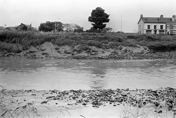
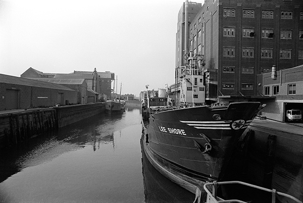
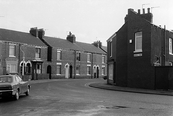
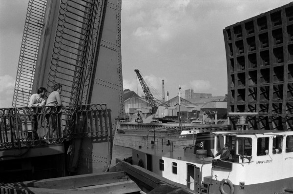
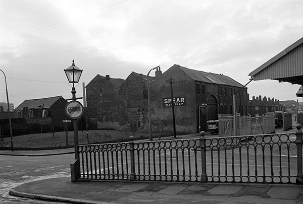
There are around 30 vessels in the Old Harbour on the River Hull, mainly in front of the wharves which are at the back of the High St. What is perhaps shocking is the complete loss of those varied frontages on the left, down as far as the large and ugly block next to Scale Lane Staith. That was one which I would have been happy to lose, but the others in their variety were an important part of the cityscape that has been lost, replaced by the dull Trinity Wharf. It isn’t bad – which might be interesting – but dull and second-rate, clearly an opportunity lost.

Further down things are a little better, though the new is perhaps not always up to the standard of the old, and then, crossing the river we now see a horrible gap, the missing tooth of Clarence Mill, which although solidly re-built after the war to something less than its previous glory was a city landmark and an iconic reminder of Hull’s past and Rank’s pioneering achievements. It could and should have been converted to new use rather than demolished, and its loss is something Hull City planners should never be forgiven for. Fortunately my view in this photograph doesn’t extend to the site of the Holiday Inn.

It is an interesting selection of vessels, including two former lightships, one the Middle Whitton and the other at left looking rather like the Upper Whitton, though it has no visible name on it. These were some of the last manned lightships to be replaced by unmanned floats with solar cells to provide power and had a two man crew who did I think two week shifts. The Whitton sands – between Brough and Whitton across the river were notorious. The Middle Whitton apparently became a houseboat named Audrey and was certainly for some years on the canal at Beverley.


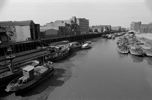
36f14: The Old Harbour, River Hull from Myton Bridge, 1983 – River Hull

15th July 2017

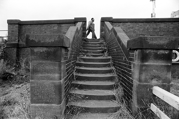
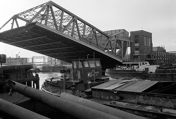
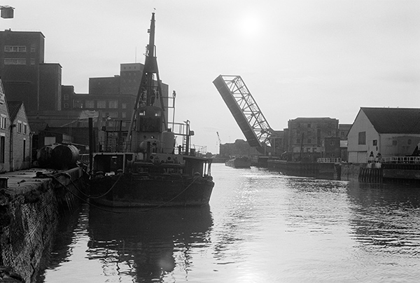
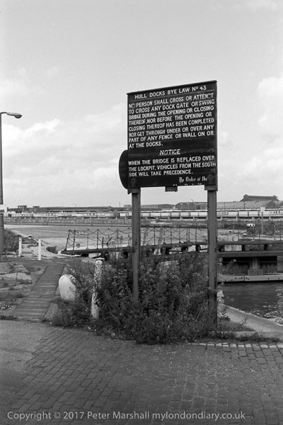
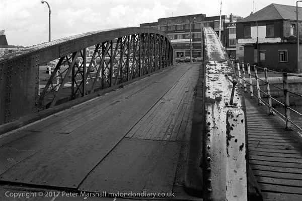
My favourite Hull footpath led across the walkway on the side of this swing bridge over the dock entrance and then between the railings and up the steps from which I took this picture to go along the roofs of the dockside warehouses.

A stern notice on the bridge warns you against entering the bridge when the guard chains are across the bridge approaches – and that you will be prosecuted if you get through under or over the guard chain.

But by this time there were no guard chains across the public footpath, and the flashing lights warning of its opening were of little use if you had already walked past them, and a couple of years before I took this picture, my wife, walking slowly pushing a buggy with my younger son in it was crossing slowly, perhaps having stopped to admire the view, when the bridge began to swing.

It wasn’t at that time a heavily used path, something of a secret known to relatively few who hadn’t worked in the docks, and probably the bridge operators had not thought to check there was nobody already on the bridge when they pressed the button for the lights and then for the bridge to swing.

I can’t recall ever meeting another person when I used the path back in the 1980s, but now it is a highlight of the Trans Pennine Trail, and when I visited it last on a fine day in February there were quite a few locals coming to stop and look at the view and to take photographs as well as several walkers setting out towards Southport, or at least on this section of the long-distance path.

I was rather sorry I wasn’t with her – perhaps it would have been a good photo opportunity – but I had walked a little further on with our elder son, and after a while was beginning to worry what had happened to her, though I think was still more interested in taking pictures.

Of course she wasn’t prosecuted – and I think got an apology for having been put in a not very dangerous situation. But Hull’s relatively new Scale Lane footbridge (built to take you to the Holiday Inn?) riding on the bridge is allowed – apparently when it was built the only such bridge in the world. The opening times – currently once every Saturday and twice on Sundays – are listed on the council web site, and it is one of Hull’s best-hidden tourist attractions. Theoretically it also opens for river traffic, though there is little of this now, and smaller craft can pass under the bridge without needing it to open. I think it has greater river clearance than either Drypool or North Bridges.


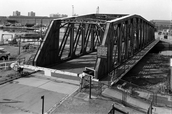
36f44: Swing Bridge, Albert Dock entrance lock, 1983 – Docks

16th July 2017

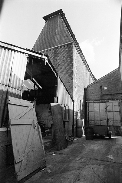
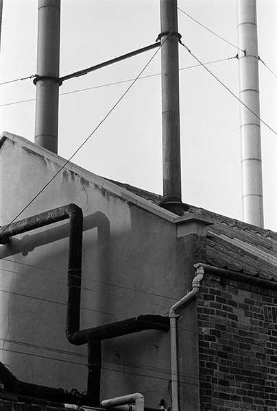
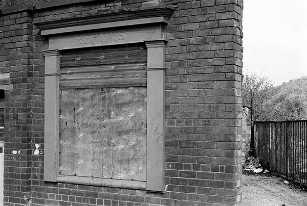
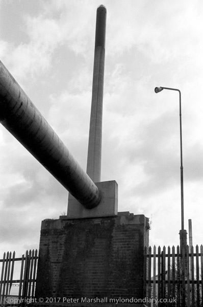
I have struggled to find where I took this picture without being able to definitely place it. The chimney in the background is that of Smith & Nephew, just a little west of Ropery St, south of Hessle Rd. There are still five existing smokehouses in the area, two in Daltry St, one in Ropery St, one in Alfred St and the last in English St, but none appear quite to fit the profile of this one, or to have a roof at the correct angle when viewing the chimney.

Nor can I find any building like the main one in the image, quite distinctive with that cut-away corner and external drainpipes. Above the lorry entrance is the name, its start and probably end missing ‘istocrat FOOD’. There was a company listed as ‘Aristocrat Foods Ltd’ but it was in Bransholme. The building at right has a sign too, though again only a part is visible, with the logo ‘nexem’ or ‘nekem’. Surprisingly there is (or was) a Nekem Ltd in Hull, but in a different area with a different logo. Neither does the incomplete name ‘J Stanley Hol’ yield me any clues – though I’m sure there will be someone from Hull able to recognise the location.

Other images taken before and after this are in the I think it likely that the smokehouse and the rest have been demolished and replaced by other buildings. The location that seems most likely is on Edgar St at the corner of Mechanics Lane.


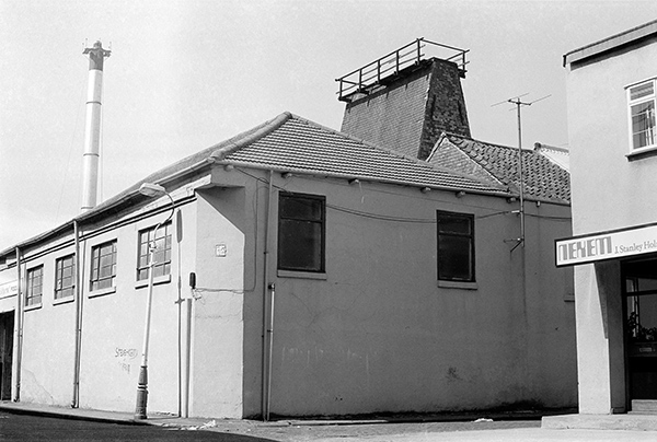
36f61: Works and Smokehouse, possibly Edgar St, 1983 – Hessle Rd

17th July 2017

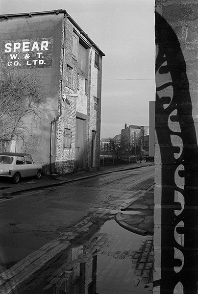
Obviously the name St Mark’s Square was a part of its attraction to me, but this was also an important site in the growth of Hull, the centre of Hull’s first out of town suburban development by Thomas English, a wealthy local shipbuilder in the first decade of the nineteenth century in an area then known as the Pottery Ground, south of the Hessle Rd. The square was then an open area surrounded by houses, but I could see no trace of that.

The cobbled area at the right and the high brick wall of an industrial building with above it the chimneys and cowls of a fish smokehouse are St Mark’s Square, and Clyens & Son Monumental Masons where two men are enjoying a break at 36 St James St. This is the best of three pictures I took with them in it.

The buildings and the cobbles are still there, though altered. The smokehouse has lost its chimneys and been capped with a roof, while the entrance in which the two men are sitting has been replaced by a wider shuttered opening. The name board has gone and a notice on the side of the building now has an arrow pointing to Wyke Electrical Controls. A faded notice for the yard behind reads J A Lorrimar & Co., Weighing Machine & Slicing Machine Specialists – Food Preparation Equipment, and the whole area was and is a maze of small industrial premises. The was still a board reading Clyens & Son Monumental Masons when Google Streetview first photographed the area in 2008, but the company is no longer at 36 St James Street, but at premises off the Hedon Rd in East Hull.


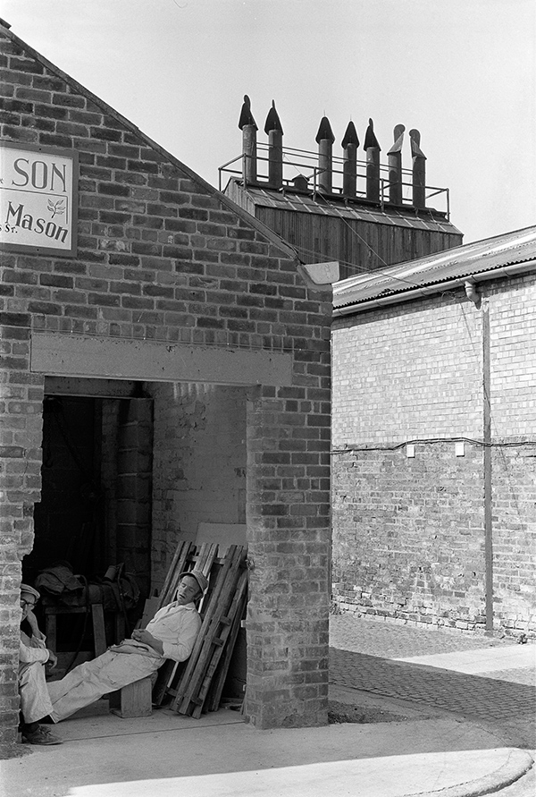
36f65: Clyens & Son Monumental Masons and St Mark’s Square, 1983 – Hessle Rd

18th July 2017

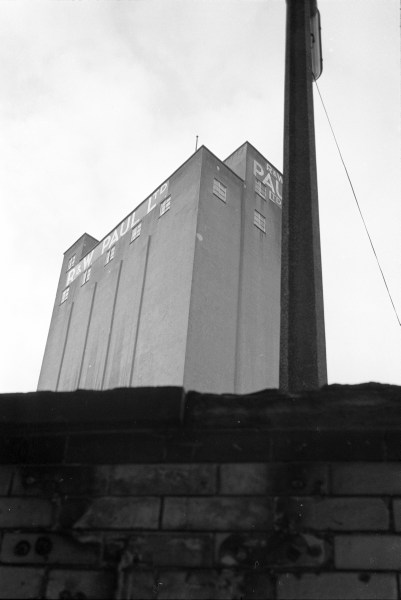
Still a familiar view, although Pauls has Changed to maizecor and that tall square brick chimney has disappeared.

I was for a while puzzled by the raised section of pavement here but much of Hull is subject to occasional flooding. The low brick wall at right of the picture is I think were the Cottingham Drain went under the road. This was culverted ten or more years before I took this picture, although at least until recently there was a little muddy area visible on that side of the road. The course of the drain through Hull can easily be seen, with a roadway, cycle path or footpath alongside most or all of its course – and the end of the footpath can be seen here running along the side of the building complex.

This area, where the Cottingham and Beverley & Barmston (‘Barmy’) drain enter the Hull is known as ‘High Flags’ and although this is often thought to refer to large paving stones on the nearby wharf where whale oil drums were handled, I wonder if it could simply have been a reference to this causeway needed along an often flooded section of road. High Flags Mill, a Grade II listed Oil Mill built around 1856 is a short distance to the north. Originally operated by Chambers and Fargus it was Hull’s last expelling mill when it closed in 1991.


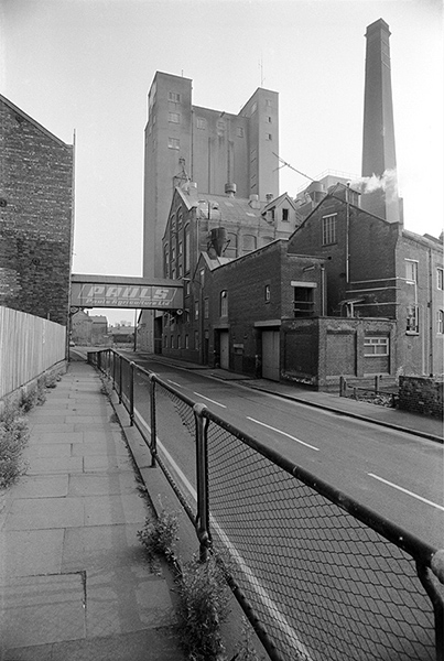
36g11: Wincolmlee, looking south towards Pauls Agriculture Ltd, 1983 – River Hull

19th July 2017

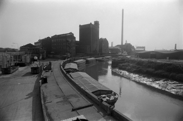
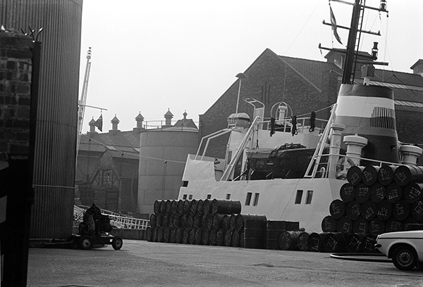
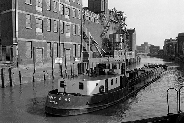
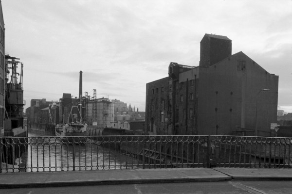
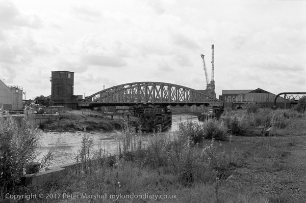
Another Chambers and Fargus mill on the east side of the Hull immediately below Scott St Bridge. This picture is taken from close to the bridge looking roughly south down-river. It still looks much the same, and is still busy, though now for Finlays, tea and coffee importers.

On the right bank, only the closest building on Wincolmlee still stands, and, in the far distance, North Bridge and the former ship’s warehouse next to it. Further down, Clarence Mill and the sites along Wincolmlee stood completely empty with just a little rubble when I walked past earlier this year.

Gino of Rochester, berthed at the mill was a general cargo coaster, originally called Ambience and built in Hull at the Drypool Engineering and Drydock Co, a ship repair company founded in 1921 by the Rix family which was liquidated in 1975, when two of its drydocks were sold to the Yorkshire Drydock Co of Hull; she became Gino in 1982. Gross weight 391 tons she was eventually sold to Qatar (along with apparently most of the UK) but unfortunately sank after breaking tow in Qatar in 1997.


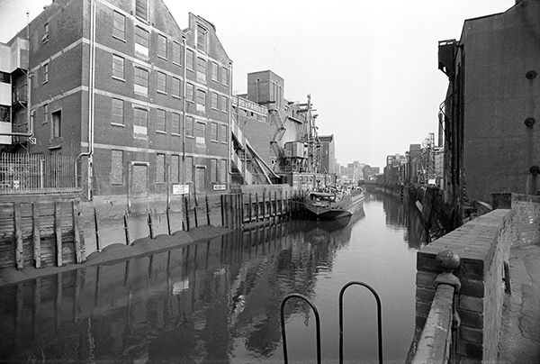
36g14: River Hull, view downstream from beside Scott St Bridge, 1983 – River Hull

20th July 2017

The Whalebone Inn has gone up in the world without losing it’s unique character since I took this picture, and is now described as Yorkshire’s hidden gem and was Hull and East Yorkshire CAMRA Pub of the Year in 2014 and 2015.

The ramshackle lean to at right disappeared years ago leaving a small open yard. The pub has its main frontage on Wincolmlee, which is around three times as wide but was also in fairly poor shape back in 1983. Then it rather seemed the sort of pub you would only enter with backup, but it is now far more welcoming.

This area, some distance north of the old city of Hull once used to be known as Wapping, probably meaning it was marshy, and streams and dykes have run through here to the River Hull since medieval times. The inn is said to date from 1791, but has had a few updates since, and the buildings look basically early nineteenth century, when it had a brewery opposite and another a few yards down Lincoln St, with three more only a little further distant and from 2003 to 2015 it had its own micro-brewery next door. The windows seem to date from a makeover in the Art Deco years of the 1920s and 30s. Paul Gibson has written a detailed account of what is know about this and other pubs in the area on his Hull and East Yorkshire History site.

A reviewer on Pubs galore describes the Whalebone Inn at length, including “The whole pub is an absolute mine of memorabilia, the highlight of which, for me, was the many wonderful black and white photos of old Hull pubs, many no doubt long since gone, most of which have a handwritten note detailing the pub’s name and location.” You could probably spend a few weeks inside looking at all of the objects and photographs while steadily working through the range of real ales.


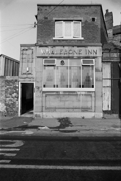
36g24: Whalebone Inn, Lincoln St entrance, 1983 – River Hull


You can see the new pictures added each day at Hull Photos, and I post them with the short comments above on Facebook.
Comments and corrections to captions are welcome here or on Facebook.
Continue reading Hull Photos: 14/7/17-20/7/17

Hull Photos: 6/7/17-13/7/17

Finally more or less up to date with the digests from my image a day Hull2017 UK City of Culture project – though you can see the new pictures every day and see them with my comments on my Facebook page – details at the end of this post.


6th July 2017

Here and for the next few pictures I have to apologise, for these are not pictures of Hull but of Goole, upstream and on the other side of the river, not on the Humber but on the Ouse, though at least in the East Riding. Goole is the UK’s most inland port, 50 miles from the sea and close to the industrial areas of Yorkshire with good canal links, as well as rail and now motorway connections.

Timber, shown in this picture still comes into Goole, largely from Russia and the Baltic States, Finland, and Sweden, and is still handled here in West Dock.

In the background at right we see Goole’s iconic (if anything at Goole can be iconic) landmarks, the listed ‘salt and pepper pots’, both water towers, and this view is from Lower Bridge St and the ship is in West Dock.


36d22: Timber wharf and ‘Salt and Pepper Pots’, Lower Bridge St, Goole, 1983 – Goole

7th July 2017

The two water towers are still a notable landmark for some miles around, and the buildings to the left of the railway line still stand, but there is now no level crossing and the buildings at the right have gone.

Both water towers are grade II listed. The more slender brick tower dates from 1885 and is approximately 43 metres high and 10 metres in diameter. It is no longer in use. It was replaced by its fatter neighbour, diameter 27.5m, height 44m, completed in 1927 with a capacity of 750,000 gallons. It was claimed to be the largest structure of its type in Europe when built for Goole Urban District Council.


36d24: ‘Salt and Pepper Pots’, Lower Bridge St, Goole, 1983 – Goole

8th July 2017

I think these steps were up to Bridge St from the dock side, and that they are now closed to the public. But Goole has changed considerably since I was there. I think the only map I will have had would have been a 1:50,000 OS map, borrowed from my local library, which at that time showed no rights of way and of course had no street names. So I simply followed what seemed an obvious route and was fortunate it took me to a footpath around the docks.

Things are rather easier now – Goole even has an online electronic interactive town guide and a conservation area guide, as well as the Yorkshire Waterways Museum and an art trail. My mother-in-law in Hull thought I was mad to visit Goole back then, but then she thought I was mad to photograph the parts of Hull I did.


36d32: Steps, Bridge St, Goole, 1983 – Goole

9th July 2017

No 1 shed was built in 1933 next to Barge Dock, Goole. Quite why someone has painted ‘Sleepy Hollow’, well before the film or TV series I don’t know, though it was probably a good description of the place.

The Legend of Sleepy Hollow was a short story by Washington Irving, first published in 1820 (though his Rip Van Winkle was more popular.) It’s a story including a headless horseman set in a Dutch settlement (perhaps there is some connection with the Dutch River just a few yards away) in New York State who is possibly one of the two male contestants for the hand of Katrina Van Tassel, riding with a pumpkin for a head on his saddle, and is popular at Halloween. There were a couple of US TV adaptions of the story in 1970 and 1980 but I doubt if they made it to Goole and the story wasn’t popular outside the USA.


36d41: No. 1. Shed, South St, Goole, 1983 – Goole

10th July 2017

There appears to be some lettering on the bow of the barge in the foreground, but I cannot make it out. Behind it are ‘Alison’ and ‘Claire’ both Goole barges.

Barge Dock was one of the original docks when the port as opened in 1826 and is now connected to the River Ouse by Ocean Lock, built 1938 and the largest in the docks.

The pub on South St, here T.C.’s Bar, is still standing and one of very few pubs on the docks still open as The Middlehouse.


36d45: No 1 Shed, Barge Dock and South St, Goole, 1983 – Goole

11th July 2017

Back in 1626 by King Charles I of England employed Sir Cornelius Vermuyden to drain one of his favourite hunting grounds, Hatfield Chase, as he was fed up with his horses getting stuck in the mud. The River Don flowed through and too often over the area, and at first this was diverted to flow into the RIver Aire rather than the Trent. But this still flooded and a new channel, the Dutch River was dug to take the river into the Ouse at Goole and was completed in 1635.

It wasn’t dug for navigation, but was used by boats despite various problems with shoals, bridges and low water at some tides. But since 1905 when the New Junction Canal from Stainforth to the Aire and Calder Navigation west of Goole was opened has almost entirely been a drainage channel.

The building of the Dutch River marked the start of Goole, but it was the arrival of the Aire and Calder Navigation in 1826 that really began the town as it is today, with its major trade being the export of coal from the West Riding to the continent. With the opening of railways – the Wakefield, Pontefract and Goole Railway in 1848 (later Lancashire and Yorkshire) connecting Goole with the West Riding and rather later in 1870 the Doncaster to Hull line of the NER – the port really took off. The port remained busy until the end of much of Yorkshire’s industry and coal mining at the end of the 1970s, and was at a fairly low ebb in the 1980s when I took these pictures.

The terrace of houses is still there on the Swinefleet Road. A few more pictures from Goole in a week or two.


36d51: The Dutch River from Vermuyden Terrace, Goole, 1983 – Goole

12th July 2017

The block of concrete is still there at the end of Ann Watson St, along with three of the wooden posts but little of the rest of the scene remains. At extreme right is the back of The Ship pub, and though the closer storage tanks have gone there are still some in the middle distance – and possibly some of the same distant riverside sheds.

This is close to where the ferry from which Stoneferry got its name used to cross the River Hull. The current pub dates from 1932, but it replaced an earlier ‘Ship Inn’ on the riverbank probably since the 17th century.

Not a lot is known about the life of Mrs Ann Watson, the widow of Reverend Abraham Watson but her will in 1720 left a legacy to provide her house in Stoneferry to provide accommodation and relief to widows or unmarried daughters of Church of England Clergymen and to to provide a school for poor girls as well as a grant of £5 towards the maintenance of any scholar of Halsham School in Holderness to go to Oxford University, all from the income from her farm lands, houses and tenements. These were obviously extensive, and included five fields to the north of Holderness Road which were sold to the Hull Urban Sanitary Authority for £16,909.7s.6d in 1884 to form part of East Park and also land sold for the track of the Hull to Hornsea Railway.

Ann Watson’s Charity continues to this day to provide accommodation and relief in need for poor women who are members of the Church of England, with preference being given to such persons who are widows or unmarried daughters of clergymen of the Church of England and to promote the education of persons under the age of 25 who are residents of or attend schools in the East Riding of Yorkshire. In 1907 Hospital Lane in Hull where Ann Watson’s alms house formerly stood was renamed Ann Watson Street.

To the north of Ann Watson St was HOMCO (the Hull Oil Manufacturing Co., Ltd.) founded in 1888 was one of the first uses of solvent extraction for oil seed processing. They were an early processor of castor oil and a soap manufacturer and were acquired by BOCM in 1922 and closed in 1953. The sign on the fence says ‘Matches & Lighters Strictly forbidden past this point, so the site here was presumably storing highly flammable materials. This site is now occupied by the Regroup (UK) Ltd oil waste disposal and re-cycling. To the north-west was a paint works, Hangers Paints, with its entrance in West Carr Lane, which I think is probably the tall building on the riverbank.

Behind me as I took the picture was the site of the General Extracting Co., opened in 1896 and bought up in 1904 by Joseph Rank. It became the Premier Oil Extracting Mills Ltd. and in 1919 was amalgamated into Premier Oil and Cake Mills Ltd and closed around 1971. There was a short branch railway line to the mill from Stoneferry Goods Station across Stoneferry Road, which was a branch from the Hull to Hornsea line. The mill is long gone and the site now occupied by B&Q.


36e35: River Hull and Ann Watson St, 1983 – River Hull

13th July 2017

South of Stoneferry Bridge is the Isis Mill, a Grade II listed building still standing (and mentioned in earlier posts.) The string of six barges gives an indication of the importance of the River Hull for transport, and beyond them a larger vessel (its name unfortunately not legible) is moored at the wharf, either at Croda’s Isis Mill or just past it at Reckitt’s ultramarine factory with its tall chimney in Morley St.

The silo and the buildings to its left are still there, but beyond it only the now unused chimney still stands. The sheds across the river with a Michelin advert on them also remain in what is now called Innovation Drive.


36e36: River Hull south of Stoneferry Bridge, 1983 – River Hull


You can see the new pictures added each day at Hull Photos, and I post them with the short comments above on Facebook.
Comments and corrections to captions are welcome here or on Facebook.
Continue reading Hull Photos: 6/7/17-13/7/17

Hull Photos: 29/6/17-5/7/17

Still catching up…


29th June 2017

This fish smokehouse is still in Subway St, though a little altered is readily recognisable. It and the premises on both sides of the entry were then the premises of G Hannath, now they have boards for Transfish Seafoods, Tudor Fisheries and J Laughton Fish Merchant.

The Hull ‘Local Listing’ notes it as “Distinctive and once commonplace Hull building type, now rare. One of only 9 surviving examples. Important reminder of Hull’s once great fishing and fish-processing industries and a significant contributor to local distinctiveness.”

Although the writer of that note obviously recognised their significance, the fact that only nine remain, and the condition of some of them are a reflection of a lack of general interest by the council over the years in Hull’s heritage. It is also interesting that the nine are only on the local list and not a single example is on the national list.


36c12: Smokehouse, Subway St, 1983 – Hessle Rd

30th June 2017

Much of the area between Hessle Rd and the docks had been flattened, leaving just a few of the older small factories, works and commercial premises but laying flat all of the working class housing. In its place came large and largely anonymous sheds such as this – which I am unable to positively identify. Almost certainly it will have altered considerably since 1983.

Clearly much of the housing was in poor condition, and some had been badly built in the first place, and the crowded area between the Hessle Rd and the docks needed dealing with, but I can’t help feeling it could have been done so much better than this wholesale mess.


36c24: Redevelopment, off Hessle Rd, 1983 – Hessle Rd

1st July 2017

Rose Downs & Thompson (now De Smet Rosedowns Limited) specialized in the manufacture of oil-milling machinery, supplying one of Hull’s major industries. Founded in 1777 it is still in Cannon St, Hull but supplies presses around the world for the oilseed and rendering industries and is a part of the Desmet Ballestra Group. Founded as ‘Old Foundry’ by John Todd, its early products included cannons (some of which were in use at Waterloo) and parts for windmills and it also became a ship chandlery. According to Grace’s Guide the company installed its first hydraulic press for linseed by 1820.

Christiana Rose, a daughter of one of the original partners Duncan Campbell, inherited the company in 1840, employing 50 men at the works in Sculcoates. In 1859 she took on James Downs as her manager and the company began to specialise in oil seed crushing machinery. Downs was made a partner and the company became Rose and Downs in 1871, the year than Christiana Rose died. Her grandson John Campbell Thompson joined the company in 1874 and it became Rose, Downs and Thompson. The company was bought by the Power-Gas Corporation in 1951 and passed through several other hands before becoming De Smet Rosedowns.

The lorry gate and wall are still there on Bridlington Ave, a little south of the junction with Cannon St, but the building behind, with its gable with ‘R D & T LTD’ on it disappeared a few years ago – and that empty noticeboard along with its small grass area and tree at the edge of the car park went some time earlier.


36c43: Rose Downs & Thompson, Bridlington Ave, 1983 – Beverley

2nd July 2017

The large building in the background on the other side of the River Hull is clearly still present on Wincolmlee, just to the north of the junction with Oxford St – and it has a similar pattern of three vertical slots – perhaps for ventilation – on the street side. A board on the wall on its left there is for Humber Fabrications (Hull) Ltd, who appear to be based in other sites on Wincolmlee and were founded some years after I took this picture.

Lime Street is quite close to the river here, and I think this picture was probably made from the road with my lens poking through the fence or through an open gate where Lime Street meets Eagle Terrace. Or I may have been able to wander a little closer. The site is now part of IBL Liquids.

The oil drums are all clearly labelled but even for those I can read offer no information of interest to me, though I can make out the word ‘OIL’ on the side of one of them. The vessel is clearly of some size, but unfortunately the name on its lifeboat is obcsured, though it appears to start ‘HAM’.

There is a large storage tank at left – still there – but that across the river has gone, along with what looks like pile of timber on a wharf opposite.


36c51: Ship and Oil Drums, Lime St, 1983 – River Hull

3rd July 2017

Google Streetview from July 2008 shows just a huge pile of bricks and rubble where the factory building on the right was when I took this picture, though the high brick wall with its peeling sign for H&L Vehicles – M.O.T Testing – Repairs – Welding – Services on the north side of Chapman St is still there, along with the metal fence and gates on New Cleveland St. The mill was demolished by a careful series of explosions in September 2007.

This was the Swan Flour Mills, Sculcoates Bridge, originally built in 1897 for Rishworth, Ingleby & Lofthouse Ltd and expanded the following year with the silo added in 1906, but almost entirely destroyed by wartime bombing in March 1941. In 1921 the company became part of Spillers. The mill was rebuilt after the war in a rather more plain style with a reinforced concrete silo beyond the brick building, which at 149 ft was one of Hull’s taller buildings. Beyond that the lower buildings are I think a part of the British Cocoa Mills (Hull) Ltd.

Lee Shore, a general cargo coaster of around 299 gross tons was built in 1954 by Büsumer Schiffswerft W. & E. Sielaff in Büsum in North Germany and went through a succession of owners and names: (1954) Labor Et Fides; (1964) Jutta Brey; (1980) Hubert; (1983) Delta Lady; before she became Lee Shore, owned by Corolan Maritme Ltd, registered in Gibraltar in 1983. A fire at Hull destroyed her wheelhouse in 1984 and in 1986 she became the NORDICA STAR and in 1990 her last name change to MILLSUPPLIER. After being abandoned when the engine room flooded in the North Sea in December 1990 she was towed to Lowestoft, and in 1994 was laid up in Rotterdam and presumably broken up.

The ship was 135 ft long and around 27 ft wide and fully loaded needed about 11 ft of water and was certainly one of the larger vessels I noted this far up the River Hull.


36c52: Lee Shore moored at Spillers mill, River Hull, 1983 – River Hull

4th July 2017

Most of this picture – the Lee Shore and the Spillers Mill at right is described in the previous post. I can see no name on the vessel at left, which appears to be a coaster of a similar size.

The low buildings are the extreme left are now the Hull Microfirms Centre on Wincolmlee, but the taller buildings where the ship is moored are at around 308 Wincolmlee have gone. I think these were a part of the Wincolmlee Oil & Cake Mill, on Wincolmlee just to the north of the Sculcoates Bridge works of John Hamilton & Co.

Hull was one of the largest centres of the oil crushing industry in the world, from around 1500 with linseed from Russia, but later with other crops including soya, cottonseed, rape, castor, palm kernels, ground nuts, sunflower seeds and more from Argentina, Egypt, India, Cyprus, the Caribbean and elsewhere, particularly across the British Empire.


36c54: River Hull upstream from Sculcoates Bridge, 1983 – River Hull


5th July 2017

This selection of pipes and chimneys was on somewhere on Lime Street, running roughly parallel to the east of the River Hull, with wharves and factories supplied by the river between. Apart from the drainpipe, the pipes are well-lagged, suggesting they carried wither steam or liquids at high temperature. I was particularly interested in the shadow of the pipe, and its shadow within another shadow, which creates a slight spatial disjunction in the lower left quarter of the image.

Most of Hull’s early industries developed around the River Hull, based on whaling and on agricultural crops brought up-river, coming both from across the Humber and from across the North Sea.

I don’t think this building or the pipes remain, though I can recall exactly where it was, probably not far from the crossroads with Jenning St.


36c66: Pipes and chimneys, Lime St, 1983 – River Hull


You can see the new pictures added each day at Hull Photos, and I post them with the short comments above on Facebook.
Comments and corrections to captions are welcome here or on Facebook.
Continue reading Hull Photos: 29/6/17-5/7/17

Hull Photos: 22/6/17-28/6/17

Another week of posts – still catching up.


22nd June 2017

Another view looking down Queen’s Terrace towards Tunis St, eight months after my previous picture, shows more properties sealed with corrugated iron awaiting demolition and a dramatic increase in the amount of graffiti on the gable end. The wicket is still there, but clearly the paint spray has arrived in Hull.

Most of the property between Sculcoates Lane and Tunis St was demolished shortly after I took this picture, though the houses across the end on Tunis St remain.


34i44: Queen’s Terrace and Tunis St, Sculcoates Lane, 1983- Beverley Rd

23rd June 2017

I’m disappointed that I missed the siege of Wyndham Street, one of the more colourful events in Hull’s recent history. As this and another picture shows, I was there just a few months before it began, photographing these US military vehicles of the Northern Allied-Axis Society in the street and Melbourne Terrace. Had I known what was about to happen I would have taken more than the three pictures I did.

Barry Nuttall was a 38 year-old who lived in Melbourne Terrace with a wife and 7 kids and his passion was military re-enactment, using old US Army vehicles and uniforms and giving displays that raised thousands for local charities. He was the self-proclaimed Major General and had an army of around a dozen officers and men (at least one of whom was a woman.)

When the council decided to carry out a comprehensive redevelopment of the whole Argyle St area in 1979 the residents set up a campaign for refurbishment rather than demolition, but unfortunately the council wasn’t ready to listen. Eventually everyone moved out except Nuttall, who decided the compensation they were offering to home owners wasn’t enough and refused to move. There were stand-offs with police and bailiffs against his army defending his property making use of their military equipment and uniforms, which drew in reporters from the nationals and made headlines.

The battle dragged on for a month, but eventually the council were able to enforce a compulsory purchase order and sent in the bulldozers, but that wasn’t the end of Nuttall’s fight. He and his supporters used the rubble they left to build a fort, which they defended for the next three years, with huge support from the community who brought in supplies.

Eventually the police responded with a siege, refusing to let in supplies or to allow anyone who left the site – where there was no gas, water or electricity – back in, but resistance and support continued and it was three years before Nuttall finally quit in 1986. During those three years he was said to have only left the site twice, once to take a petition to Parliament in London and the second to marry his second wife – when Hull singing star Joe Longthorne lent him his Cadillac for the occasion.

One of Hull’s great characters, Nuttall died in 2011


34i52: Northern Allied-Axis Society vehicles, Wyndham St, 1983 – Argyle St

24th June 2017

I have to admit that I took this one mainly for its name, Marshall St. It’s a fairly ordinary street off west from Newland Avenue next to the old primary school, now converted into flats, built in 1896 for the Hull School Board (with a larger senior school behind added in 1900) shortly after these streets just south of the railway bridge. The development was in land left after the Hull & Barnsley railway was completed in 1885.

The school creates a slightly unusual road pattern for Hull, with a road on each side of it – this and Reynoldson St – running parallel well past the end of the school site and then sweeping around to meet in the middle, with Reynoldson St then continuing straight on to make the shape of the streets like a tuning fork (a two-pronged fork). The street ended at the Cottingham drain and is still a cul-de-sac for cars, though on foot you can walk along the now-culverted drain (Jack Kaye Walk) to either Ella St or under the Hull & Barnsley line to Goddard Ave. There are no ‘terraces’ off the two ‘prongs’ of the fork, while the ‘handle’ has six to the north and four to the south.

When I last looked, this corner was still very much as it is in this picture, except there are now rather more vehicles parked most of the time.


34i56: Marshall St, 1983 – Springbank

25th June 2017

Another picture of the site where Major General Barry Nuttall made his stand against demolition of his home together with his colleagues in a few months after I took this picture, resisting demolition for a month, then building a fortress from the rubble and defending it against a police siege for three years. See my previous post for more detail.

Unfortunately I didn’t go this way again for some years, perhaps because most of the area was a giant building site. I think that the Hull Daily Mail had stopped reporting it by the time I was next in Hull.


34i66: Northern Allied-Axis Society vehicles, Wyndham St & Melbourne Grove, 1983 – Argyle St

26th June 2017

Somewhere in my wanderings between Freehold St and Cranborne St, off to the north of Springbank I came across this terrace with a rather curious entrance, what looks rather like a rustic aviary.

Much of the area was then laid out with streets with slightly larger houses than many in Hull and without terraces. More or less the only ones that remain are on Mayfield St, but none seem to look like this one – even without the structure across the front.

It seems to be a double terrace, with four houses on each side and then a wall separating it from a similar terrace from the next street. The houses look in decent condition and are all occupied. Perhaps someone who lived in the area in 1983 will recognise it.

34j25: Terrace, Springbank area, 1983 – Springbank

27th June 2017

The Kenfig, a grab hopper dredger built in 1954 by Henry Scarr Ltd of Hessle for the British Transport Docks Board at Port Talbot. It was one of the dredgers used to clear the passage into Humber Dock for the Marina, and in 1983 was bought by Jones & Bailey Contractors Ltd of Hull who renamed her Hedon Sand in 1984. Around 5 years later she was scrapped at New Holland.

Kenfig was moored just a little upstream of Drypool Bridge on the River Hull for most of the 1980s, seldom if ever moving.


35y14: Kenfig above Drypool Bridge, River Hull, 1983 – River Hull

28th June 2017

Some of my contact sheets of films taken back in the 80s present a number of mysteries, and this was one of them. There are 35 pictures from a single film in six strips of six (with one blank) on the contact sheet in the order in which they were taken, and helpfully I’ve added brief locations to some of them – normally indicating when I’ve moved to a different street or place. The first five pictures in Hull are followed by a single image of the Ropery at Barton upon Humber and the remainder of the film was taken in Hull.

The next nine pictures are of sites I photographed on other occasions and know the exact location, but then come three of a pattern of windows etc on a wall which I labelled ‘Off Hedon Rd’ but almost certainly I had confused with that other H, Holderness Rd. Where I took the next two, one of which shows a gate into a large and fairly empty industrial yard with a sign on it pointing to ‘Beach and Cliff Walk’ is anyone’s guess, though it must have been someone’s idea of a joke.

The next frame is looking upstream along the River Hull from Sculcoates Bridge and is followed by today’s picture labelled Wincolmlee and then several labelled Stepney Lane.

From this, I guessed that this picture was made on Wincolmlee somewhere between Chapman St and Fountain Rd, but when I walked along there a few months ago it was nowhere to be seen. Google Streetview on this road goes back to July 2008, and taking a virtual walk then the facade, though much altered, leapt out at me.

The blocked doorway now had a door in it, smaller and blue and wooden, and a ventilator had been added in the wall to its left, but it was clearly the same – and in 2008 had a large notice ‘Barker & Patterson Fabricators – Mild – Stainless Steel & Aluminium – Structural Steelwork & Engineering Services, along with another from Scots property company announcing the c.5,900 sq ft site was now for sale due to relocation – and a quick Google found B&P now in nearby Oxford St.

In 2017 it is now Fox Precision Engineering Ltd, and looking rather different to the old facade shown here, which has been completely cladded. Had I stepped back across the road for an image showing the building as a whole it would however have still been recognisable. The site extends to York St which Fox list as their address. This building had also been Barker & Paterson’s ‘back door’.

There remains the mystery of a name on the blocked letterbox in this picture. Looking at the full size image I can see parts of the letters ‘EDWAR’ at its start, probably ‘Edward’ or ‘Edwards’. It would be interesting to know what this building, with its rather grand doorway whose remains attracted my interest was originally built as, but I can tell you no more. It was a surface that seemed to tell a story but one I’m still unable to reveal. And perhaps it’s better that way.

Streetview, usually unreliable on such things, tells me the address is 297 Wincolmlee.


35y35: Frontage around 297 Wincolmlee, 1983 – River Hull


You can see the new pictures added each day at Hull Photos, and I post them with the short comments above on Facebook.
Comments and corrections to captions are welcome here or on Facebook.
Continue reading Hull Photos: 22/6/17-28/6/17

Hull Photos: 15/6/17-21/6/17

I’ve got rather behind on posting these digests from my image a day Hull2017 UK City of Culture project – too much happening elsewhere – though I have so far managed to post a new picture every day. Purists might object that some the more recent ones have been of Goole, but these are all of Hull. I’ll try and catch up over the next few days. As usual, comments and corrections on pictures and my text welcome.


15th June 2017

I have only the vaguest idea where this photograph was taken, but think it was somewhere on or near Charles St where considerable clearance was taking place for the building of Freetown Way which opened in 1986.

I was intrigued by the sun ray pattern of the sheets of material covering the window and the top half of the right hand door. There was what appeared to be an opening in section at the right of the window, which was now part covered by a strange structure of boards with four planks fixed on top, joined with gaps at the corners by metal straps.

It seemed too that the door had been fully covered, but the bottom section torn off, taking a little of the top too. It was all something of a puzzle, if inconsequential.

Though I also photographed this in colour where the oranges and yellows and red brick add to the impression of warmth and sun, I think I prefer the more austere pattern of this black and white image. I am currently scanning many of my colour images (there were around 40 in the 1983 Ferens show) though I haven’t yet managed to find all of those I took and will add some to the web site later.


34g62: Property awaiting demolition in the Charles St area, 1983 – City Centre

16th June 2017

This was taken close to the railway line somewhere near the end of Gladstone St, and that the yard is probably now a part of the large car park between there and Argyle St, and where I was standing is probably now on the edge of the landing ground for the Air Ambulance helicopter. The tall modern building of Hull Royal Infirmary and the older building on the left with a chimney showing behind the right-hand tower indicate the location fairly precisely.

It was perhaps fortunate that the hospital was so close, as this was obviously a dangerous place, with the welcoming notice on the gate ‘KEEP OUT – ANYONE FOUND IN HERE WILL BE SHOT’ with a double underline under that last word. Usually Hull is a very friendly place and this came as something of a shock.


34h15: ‘KEEP OUT – ANYONE FOUND IN HERE WILL BE SHOT’, Gladstone St area, 1983- Argyle

17th June 2017

Ellerman’s Wilson Line ceased trading in 1973, ten years before I took this picture on Bishop Lane Staithe, reached through an archway from High St. The site has changed rather since I took this picture – the gates and the building to their left are gone completely and that at the back of the small enclosed yard has lost those small windows, replaced rather more and larger ones, nicely in keeping with the building, though some of the brickwork doesn’t quite fit in.

The stone plaque under the window at right seems rather worn and I can’t quite make out what it is from my picture. It appears to have a shield of some sort on it and the listing text says it has the date 1655, though the warehouse, now flats was rebuilt around 1800. The building in the centre of the picture is also I think listed and dates from 1829, but only the river and High Street frontage are of any visual interest.


34h61: Ellermans Wilson Line Bishops Warehouse, 1983 – Old Town

18th June 2017

I took several pictures walking along the disused Hull Barnsley and West Riding Junction Railway and Dock Company (later it became the Hull & Barnsley) railway embankment which opened in 1885 which ran into Cannon St station, looking down onto the tightly packed terraces. Cannon St was Hull terminus of the Hull & Barnsley Railway, which was originally intended to run closer to the city centre to Charlotte St or Kingston Square, but the company ran out of money. It site on Cannon St is now occupied by the Motor Vehicle department of Hull College, and only some of its gates remain. The station closed in 1924 after the railway which had just been bought by its rival the NER ( North Eastern Railway) became part of the newly re-grouped LNER and all passenger services ran into Hull Paragon.

Although my contact sheets show the location Bridlington Avenue, a long and winding street that in part runs parallel to the former track, looking at maps from the era convinces me that these pictures were takin a little further north, looking down on the terraces off of Fleet St. This fits better with my contact sheet of the whole film which shows me before this photographing on Sculcoates Lane and afterwards going down Stepney Lane. Clinching the matter in the full size version above the rooftops at the left the dome of Beverley Rd Baths can be seen.

This was clearly a densely packed area about to be cleared, with virtually all properties empty and nothing that was there then remains. This and the few other pictures give a good impression of the dense packing of houses with the terrace system with each house having a small yard with an outside lavatory. A narrow alley in the middle of this picture led to the back gates to these yards. A second picture (click ‘Next’) shows the view from just a few feet to the right.


34i11: Fleet St and terraces from the Hull & Barnsley embankment, 1983 – Beverley Rd


34i26: Fleet St and terraces from the Hull & Barnsley embankment, 1983 – Beverley Rd

19th June 2017

Another picture from the disused Hull & Barnsley embankment, looking down along one of the terraces to Fleet St. Around half the houses in the terrace are already emptied and their ground floor bay windows covered with corrugated iron to prevent squatting.

Telephone wires run to virtually every house in the picture. Thanks to Hull Corporation running its own telephone system, almost every house had a telephone, though many of these would have been shared ‘party’ lines, where when you picked up the phone to make a call you would often hear your shared subscriber already using the line – and could either listen in or, as you were expected to do, put down the receiver and try again later. Local calls were untimed – and for 2p you could talk for hours, and people did. Some of those who grew up in Hull still do!

Along the bottom of the image is a typical railway fence with its close solid wood posts.


34i24: Fleet St and terraces from the Hull & Barnsley embankment, 1983 – Beverley Rd

20th June 2017

The off-licence is still there on the SW corner of Nicholson St and Sculcoates Lane, now calling itself Sculcoates News and no longer part of the Bass Charrington empire which no longer exists, selling off all its pubs in 1997.

That loyal flag celebrating the Queens Silver Jubilee is also long gone – and I think was already a little faded when I took the picture.

Also gone is the doorway at the left, but the rest of the surroundings remain more or less as they were in 1983, for a few hundred yards down Nicholson St, some of the streets off it and those to the north of Sculcoates Lane. Somewhere around here the Corporation bulldozers ran out of steam, though not before they had destroyed much that could have been better given new life rather than demolished.


34i32: Off Licence, Nicholson St corner of Sculcoates Lane, 1983- Beverley

21st June 2017

I think that this blocked up window was next to the site of the railway bridge which carried the old Hull & Barnsley Railway across Sculcoates Lane. I can’t remember for sure if that bridge was still there in 1983, and can find no record of when it was demolished. Although passenger traffic on this branch to Cannon St ended in 1924, the line was only closed for goods in 1968, and the bridge was still there when I first walked along this road in the early 1970s.

Certainly the embankment leading to the bridge was still there – and I think is what can be seen on the right of this frame. Later much of it was removed to make a gentle slope up from the road.

Later the embankment was removed on both sides of Sculcoates Lane, probably to make the former rail line more accessible to pedestrians and cyclists.

I’ve no real idea either what kind of ‘REPAIRS’ once went on inside these premises, which look like a later single storey addition to a larger building which can be glimpsed at top left, in what looks like older and less regular brick. Memory, so often fallible, suggests it was a cobbler.


34i35: Repairs, Sculcoates Lane area, 1983 – Beverley


You can see the new pictures added each day at Hull Photos, and I post them with the short comments above on Facebook.
Comments and corrections to captions are welcome here or on Facebook.
Continue reading Hull Photos: 15/6/17-21/6/17

Hull Photos: 8/6/17-14/6/17

8th June 2017

An oil products tanker, empty and high in the water, speeds up the River Hull as the Drypool bridge begins to lift – when fully raised it is only a little short of vertical. Drypool Bridge, built in 1961 to replace an earlier swing bridge, is a Scherzer rolling lift bridge. Patented by William Scherzer in the US in 1893, two months before his early death at only 35, US Patent 511,713 describes the principle clearly:

“A lift-bridge having a moveable span provided at one end with a curved part adapted to rest and roll upon a stationary supporting surface. Other characteristics noted in the patent include: teeth or projections on the said curved part adapted to interlock with projections on the supporting surface to hold the said curved part from moving or slipping on said surface; and means for moving the span, comprising a horizontally moving part connected with the span at or near the central point of said segmental or sector-shaped part.”

This design takes up little space and by rolling backwards away from the river it leaves this entirely clear for navigation. With the weight of the bridge being balanced by a heavy counterweight at its rear, relatively little energy is needed to raise the bridge. It was a remarkably simple and elegant invention.

As a part of the celebrations in Hull’s year as City of Culture, Drypool Bridge has recently been repainted from its rather plain blue (enlivened by a little rust) to a pattern celebrating Victorian mathematician John Venn (1834-1923), born in Drypool where his father was rector. He moved away from Hull when he was seven and attended schools in north London before going to Cambridge. So far as I’m aware he had no further connection with Hull. But the bridge does look quite pretty in the pictures I’ve seen of it.

I’ve not been able to find any information about MV Mister Humber moored in the foreground. The two barges in the distance are Poem24 and Kago.


33h13: Drypool Bridge raised for traffic on the River Hull, 1982 – River Hull

9th June 2017

The shadow on the wall at the right of this picture is of the gate into Mandela Gardens, leading now to the StreetLife Museum. The warehouses at left, 172 High St, have been converted into flats but still look rather run down. It’s a little difficult to recognise them as the bricks have been covered, but the large central blocked doorways at ground and second floor level are still there, though windows have been added on the first and second floors.

George Yard, then a pedestrian way only, marked by a post to stop vehicles has now been widened and renamed Gandhi Way, and there is a bust of him in Mandela Gardens, unveiled in 2004, donated by Hull’s Indian community, behind the wall on the right of the picture.

John Wesley preached at the new Methodist Chapel in George Yard in 1788 on one of his many visits to Hull (the first in 1752 ended in a riot) more or less opposite Wilberforce House on the other side of High St. But by that date William Wilberforce had left Hull to live in London, and it is unlikely that the young Wilberforce had been allowed to go and hear this powerful preacher against slavery on any of his earlier visits as his mother was strongly opposed to Methodism – and brought him back to Hull from London when he was 12 in 1771 fearing he might be influenced by Methodist friends of the relatives he was living with, and sent him to school in Pocklington to avoid Hull Grammar’s Methodist headmaster.


33h23: Dereliect warehouse, High St, 1982 – Old Town

10th June 2017

E E Sharp & Sons Ltd at 158/9 High St, were, according to the notice on their doorpost, ‘Dealers in Ships Bonded Stores, Ship Chandlers, Sail Makers etc’.

The business was founded here in 1868. Mr William Rayment, born in 1829 was from 1875 a member of Hull council and an Alderman for Coltman St Ward from 1886 and Mr E T Sharp died in 1921. As well as the High Street premises, they also had offices in Bond St. The High Street premises were reported as being badly damaged by a fire in 1907. In 1911 they are listed as General Agricultural Merchants and Manufacturers. In 1932 the Hull Daily Mail published a notice of the voluntary liquidation of Rayment Sharp Ltd, and its purchase from the Receiver in 1932 by EE Sharp Ltd.

The window and door and the names from the ground floor have gone, and the front of the building is now a solicitors, with a wide entry through the centre to ‘The Sailmakers Arms’ pub. I can’t vouch for it but it is supposed to serve good pies and decent beer. Rather surprisingly it was selected as one of five ‘historic’ Hull pubs by the community arts group, Cascade, who got a £40,300 grant from the Heritage Lottery Fund for an oral history project in 2011, despite only being around 20 years old.


33h32: E E Sharp & Sons Ltd, Sail Makers & Ship Chandlers, High St, 1982 – Old Town

and a second picture taken at the same time:


33h33: E E Sharp & Sons Ltd, Sail Makers & Ship Chandlers, High St, 1982 – Old Town

Four months later, in April 1983 I took a further picture of the same shop. The only apparent change was that the doors were now both closed.

11th June 2017

A pile of odds and ends from ship maintenance near the entrance to the Union Dry Dock was topped by a boat. Behind it the towers are those of Rank’s Blue Cross Animals Feed and others to the north of the main Clarence Mill buildings.


34g22: Union Dry Dock, Great Union St, 1983 – River Hull

12th June 2017

The Union Dry Dock on the east bank of the River Hull was full of water with no ship being worked on, its gates open to the River Hull and a rather solid looking bridge taking the riverside path across, though I think the path was still closed by various obstructions at this time.

On the other side of the river are buildings on Dock Office Row, as well as the large bulk of Hull College beyond. Past the chimney on the right is the crane, a Scotch Derrick, now one of Hull’s listed buildings and the shed of the Yorkshire Dry Dock Company on the west bank of the River Hull.

This dry dock is still there, though silted up, and with a rather fancier bridge across its entrance. The factory and chimney and the Yorkshire Dry Dock shed have gone, and the riverside between Drypool Bridge and Charlotte St stands empty and deserted, as if Hull has not found a way to incorporate its heritage into the city.


34g26: Union Dry Dock, Great Union St, 1983 – River Hull

13th June 2017

Chambers & Fargus, an edible oil refiner and seed crushing company, was founded in 1854 by Henry Waudby Chambers and James Fargus and was at High Flags Mill at 200 Wincolmlee few hundred yards upstream on the opposite side of the river from their factory on the left of this picture.

The High Flags area had formerly been part of Hull’s whale oil industry according to an article in the Hull Daily Mail about the possibility of their former mill there being converted in to riverside flats and High Flags Wharf got its name from large flagstones there to make it easier to handle the large barrels of whale oil landed there.

Chambers & Fargus imported linseed and rape from the Baltic to crush in hydraulic presses, producing oils for use in paint, linoleum, and other products and leaving ‘C & F Super Cake’ animal feed. Later soya became an important product for them.

In 1905 the firm was incorporated under the Companies Act 1862 as a private limited company. In 1907, two years later it purchased the former Anglo-Egyptian Oil Mills and Refinery in Lime street on the left of this picture, though most of this factory was rebuilt after a disastrous fire in 1937. The company went public in 1947 and was sold to the Swedish Karlshamns group in 1989. The factory is still there now, looking much the same as in 1983, and there were clouds of steam coming from it when I last went past.

The site is now owned by Finlays, part of an international company founded in Glasgow in 1750 trading with the British empire, particularly in cotton. It is now principally focused on tea but also coffee and other beverages, with “tea estates, extraction facilities for tea, coffee and plant extracts, packing facilities and R&D labs across four continents.”

The Humber Star was built in 1969 and was owned by John H Whittaker (Tankers) Ltd of Hull, an Oil Products Tanker of 274 tons gross, built at Harkers of Hull. In 2009 she was an effluent carrier owned by Oran Environmental Services and sank at her berth in Southampton. Later with name changed to Wade Stone she was detained elsewhere in Southampton in 2011 for multiple breaches of safety and was arrested in Malta in 2013 as Kara. This vessel appears now to have been scrapped.


34g42: Humber Star on the River Hull from Scott St, 1983 – River Hull

14th June 2017

Two men share a few words with a member of crew as the Humber Star goes through Scott St Bridge, the flag of John H Whittaker (Tankers) Ltd clear on its funnel. The two men on the bridge are I think the bridge operators, with a small panel behind them with electrical cables leading off left. The two bascules of Scott St were raised by an electrically powered hydraulic system, which when first built was presumably linked to the nearby hydraulic power station, the first such public utility in the UK. The Grade II listed bridge has been held in raised position to road traffic for years and allowed to decay by Hull Council.

The vessel was actually going backwards upstream slowly on the tide, and I took four pictures as it approached and came through the bridge (this was the last), as well as one of the bridge opening before it arrived. The river here is too narrow for a vessel of this size to turn around.

At the wharf beyond is Bonby, empty and high in the water and waiting to be loaded with sand or gravel. Bonby is a village in North Lincolnshire a few miles south of Barton upon Humber.


34g44: The Humber Star goes through Scott Street Bridge, 1983 – River Hull


You can see the new pictures added each day at Hull Photos, and I post them with the short comments above on Facebook.
Comments and corrections to captions are welcome here or on Facebook.
Continue reading Hull Photos: 8/6/17-14/6/17

Hull Photos: 1/6/17-7/6/17

1 June 2017

When I scanned this image for the Hull photos site I couldn’t remember where I had taken it, looking up somewhere from the south and east at the R&W Paul silo which still dominates the area close to Scott St Bridge, though now with the name Maizecor. Before taking it I had walked along Lime St and then turned down Jenning St to cross Scott St bridge – something which is unfortunately not now possible.

Working from the picture I’m now sure it was taken from the end of Scott St beside the river, probably from inside the urinal, now long demolished, which was tucked into the corner beside the River Hull and presumably drained into it. Much of the urinal wall in the bottom third of the picture has been knocked down, though a section remained last time I walked past and the concrete lamp post is still there. Quite a sizable tree has now grown in the corner from where I think this picture was taken.


33g25: R&W Paul silo from Scott St urinal, 1982 – River Hull

2 June 2017

The pipe bridge across Lime St is still there, between the riverside wharf on the right and the storage area at the left of the road. The lorry leaving the wharf is from Cargill, a company who, according to their web site have only been operating in Hull since 1985 and operate the ISIS mill in Morley St. Cargill is a giant US private company founded in 1865 and still owned by the Cargill family, with most of its business in food and agricultural products.

The pipe bridge now carries the name ‘IBL Bulk Liquids’ and LIme St is one of two company sites in Hull, the other being at the King George V dock. They began in Hull in 1947 with “a few small tanks on the river Hull”, presumably at this site, storing latex imported from the Far East but now offer a wide rang of bulk liquid storage in Hull. They also offer other services in Hull, including a public weighbridge, and you can see a small sign for this in front of the tanks at the lower centre of the picture.

The vertical tanks, one with a spiral stair around it are still there, just to the south of Hodgson St, but most or all of the others have now gone, although there are still storage tanks along the street. At the end of Lime St the building on the corner close to North Bridge is still there, though no longer a bank. It was at one time a bar, but was empty when I photographed it in February. Some buildings remain on Lime St, but others have been demolished.


33g35: Bulk storage, Lime St, 1983 – River Hull

3 June 2017

Another view of the Hull Ships Stores on the west bank immediately downstream from North Bridge, with at left the remains of the old North Bridge at the end of Charlotte St, and above that the rear of Hull College. Hull Ships Stores, a ship supplies warehouse built in 1870, architect RG Smith, were Grade II listed in 1994, a few years after they were converted into flats in 1989 as Northbridge House.


33g52: Hull Ships Stores, Charlotte St, 1982 – River Hull

4 June 2017

It was the name ‘Hull Truss & Surgical Co’ in a curve around the arch above the doorway which I’m sure made me photograph this shop front in Dock St on several occasions, though I never made my way inside. It obviously appealed to others too, as although the shop is long gone, the name has survived and has been repainted on the section of the front wall still standing in a similar fashion above the bricked up doorway. I deliberately framed the ornate bracket above the doorway to make its truncated form resemble a crucifix, seeing the building as a kind of temple to the mysteries within.

The arch has been plastered over and the name repainted in bolder pale blue letters with a white drop shadow effect, and the door and window filled in. It is no longer a shop but simply a brick wall in front of a parking area between ‘The Purple Door’ lap dancing club and a chunky concrete block on the corner of Dock St and Grimston St.

Then the window display was crowded with boxes and posters of body belts, elastic support stockings and tights and condoms. I never saw anyone enter or leave and it seemed tot be on its last legs, with peeling paint. The sun blind was faded, tatty and dirty, and I think no longer ever in use and there was a curious kind of stained glass panel in the top section of the window. Whatever had once been painted on two dark panels inside the archway was no longer visible. The white-painted brick made it a little tricky to photograph, and I’m not sure I ever got the exposure quite right.

Dock St is of course now nowhere near a dock, running parallel to and a short distance north of Queen’s Dock, closed in 1930 and bought by Hull Corporation who partially filled it in during the 1930s to provide a slightly sunken and rather boring public garden, though it does sometimes have some nice flower displays. A “major public realm design competition” for the gardens and neighbouring Queen Victoria Square was announced by Hull Citybuild in 2006, but though much needed appears never to have happened.


33g53: Hull Truss & Surgical Co’. Dock St, 1982 – City Centre

5th June 2017

Great Union St is a street that most living in Hull avoid, or drive down quickly on their way to Hedon Road or the A63, not a street with a great deal to offer other than traffic. It ran from close to North Bridge to the Hedon Rd, and now continues on to Garrison Rd.

The office through whose window I took this picture was not far south of North Bridge, and the building reflected in it may still be there, just beyond Hyperion St on the East side of the road. Where the office stood is now the parking area at the front of ‘The Crossings’, a hostel and centre for the homeless.

I photographed the interior of this office on several occasions, always from the outside when it was locked and empty.

The poster at right is for Ruston Marine Diesel Engines, a company which dates back to the 1840 engineering and millwright firm started by James Toyne Proctor and Theophilus Burton in Lincoln in 1840; Joseph Ruston joined them as a partner in 1857, but Burton didn’t get on with the new partner and left the following year and the firm became Ruston Proctor & Co. They had great success building traction engines and steam locomotive and had 1,600 employees when they became a limited company in 1889.

During the First World War they were Britain’s largest builder of aircraft engines, producing them for 1,600 Sopwith Camels. In 1981 they with Richard Hornsby & Sons of Grantham, becoming Ruston & Hornsby Ltd.

Rustons were unsuccessful when they tried to become car manufacturers after the First World War, building cars that were too heavy and too expensive (perhaps based on their wartime experience as builders of some of the first tanks) but soon became a major producer of small and medium size diesel engines for gas turbines, railway locomotives and marine use.

Rustons were taken over by English Electic in 1966, who moved diesel projection to their Stafford and Newton-le-Willows factory, and later became part of GEC, whose logo is at bottom left of the poster. The gas turbine division which remained in Lincoln was later merged with the French company Alsthom and was sold to Siemens in 2003.

The ship in the poster is the 1597 tonne coaster Surreybrook, built in Selby in 1971. She sailed under a whole string of names – 1982 Romana – 1990 Lito – 1991 God Spirit – 1993 Aquarius – 1994 Serenade – 1998 City Of London, although a photograph taken of the CIty of London shows her original name still faintly visible. Berthed in distress in the harbour at Marseilles in January 1999 she left only to be towed away to the breakers at Aliaga in Turkey in September 2003.

PoLadaire is a trade mark of Porter-Lancastrian Ltd of Bolton who made refrigeration equipment, vital for freezing fish at sea and conveying other perishable goods, and at the extreme left is part of another poster about diesel engines with the GEC logo.

But the main point of the picture for me when I took it was the empty plinth, protected by ropes. I saw it as signifying the state of industry, particularly the fishing industry, in Hull. Though a few months later when I walked past again I made another image in which the plinth was occupied.


33g61: Empty plinth, Great Union St, 1982 – East Hull

6th June 2017

I took what was for me at the time the remarkable number of six frames with more or less the same view (this was the first) as the boat moved slowly away under Drypool Bridge downriver, the final three in portrait mode to capture more of the reflection at left.

The buildings at the extreme left are still there, though I think re-roofed, and the tall buildings behind of what is now the Gamebore cartridges but was then part of Rank’s Clarence Mills are still there but now off-white. The main building of the Clarence Mill behind the ship is now sadly gone – a great loss to Hull – and as yet nothing has taken its place, with plans for a hideous hotel to provide beds for Hull’s year as city of culture having fallen through. Also gone now is the warehouse building just the the right of the bridge, and the sheds of the dry dock at right.

The bridges across the Hull opened fairly regularly back in 1982, causing long holdups in the traffic, but openings now are rare events, and much of the traffic goes over the Myton Bridge which has a much greater clearance above the water. Few if any vessels come up the River Hull now which would need it to swing open.


33g62: River Hull and Drypool Bridge, 1982 – River Hull

7th June 2017

Joseph Rank Ltd had mills both north and south of Clarence St immediately to the east of Drypool Bridge, and both were largely destroyed by bombing and the subsequent fires in May 1941.

The mill to the north of Clarence St was rebuilt and in part was the Blue Cross Animals Feed premises which remained in use until around the mid-1980s when the site became the Gamebore Cartridge Company. Blue Cross was Rank’s trade name for animal feeds.


33h12: Blue Cross animal feed mill, Clarence St, 1982 – River Hull


You can see the new pictures added each day at Hull Photos, and I post them with the short comments above on Facebook.
Comments and corrections to captions are welcome here or on Facebook.
Continue reading Hull Photos: 1/6/17-7/6/17

Hull Photos: 25/5/17-31/5/17

I seem to be getting a little behind with these posts. Sorry, we’ve been a little preoccupied in the UK with an election lately. But I have managed to keep posting a picture every day to Hull Photos.

25 May 2017

Weeds have sprung up around the base of the noticeboard for Hull Docks Bye Law No 43, but the sign is still in good condition, though hardly needed as the swing bridge and lock gates are no longer in operation.

There is still water in the entrance lock, and also some in the dock beyond, though much of it was badly silted after almost 7 years of closure. On the dock side opposite are rows of caravans, newly made and waiting to be sold, and behind them, on the other side of the hidden railway tracks, industrial buildings around West Dock St, some still recognisable – I think Batty Joiners and buildings at the rear of GFG Plastics.

The railway tracks were soon to be replaced by the South Docks Road, under construction in 1984 and renamed the Clive Sullivan Way after the death of the famous Welsh rugby league star from cancer aged only 42. He played for both Hull and Hull KR and became the first black captain of any British national sporting side in 1972. His 250 tries in 12 years at Hull remains a record for the club (and there were another 118 for Hull KR.)


32t42: Hull Docks Bye Law No 43, St Andrew’s Dock, 1982 – Docks

26th May 2017

This notice ‘ALL CREWS TO BE DOWN BY 11AM FOR ORDERS OR SUBSTITUTES WILL BE FOUND’ was in surprisingly good condition and suggests that this office in a building on St Andrew’s Dock may still have been in use, despite the dock having closed almost 7 years earlier.

I cannot now recall exactly where this door was at St Andrews DOck, but it must have been in a fairly dark area to have forced me to use flash to record it. Although I carried a small electronic flash unit in my camera bag, it was seldom used, not least because the results were not entirely predictable – and you only found out if they had been successful when the film was developed. Later I bought an expensive flash meter which removed most of the doubt.

British United Trawlers Ltd had led to move from St Andrews Dock, to accommodate its large freezer trawlers, but the move to William Wright Dock (the western end of Albert Dock, next to St Andrew’s Dock) took place as the Cod Wars with Iceland’s 200 mile limit and further restrictions from EU entry meant there was almost nowhere for Hull’s fleet to fish. Two Hull family firms J Marr and Boyd Line survived in the later years. Boyd was taken over by the Icelandic company Eimskip in 2002 and Marr bought by Reykjavik based UK Fisheries, part of the Samherji group in 2006.

My flash technique was rudimentary in the extreme – the flash mounted on the hot shoe of the camera. This was probably taken with an Olympus OM2 which had one of the most advanced flash systems then available, the TTL OTF Auto Flash Exposure Control system which allowed the camera to meter flash, rather than relying on a photo-cell in the flash unit or, more often, a calculation using the flash guide number and the subject distance.


32t43: Notice to fishing crews, St Andrew’s Dock, 1982 – Docks

27th May 2017

This was the western end of those two pipes which can be seen on the opposite side of the dock entrance. In my picture they appear to descent from the heavens, but in reality they came from the first floor of the building to my left, out of site as I took the picture, then identified as ‘Industrial & Maritime Riggers Limited’ but formerly the former Boston Deep Sea Fisheries Ltd office and the Sea Fish Industry Authority.

The Bullnose was named for its shape, jutting out in to the river at the mouth of the St Andrew’s Dock entrance channel, and apparently men who had not found a place on a crew would wait there in the hope of jumping down into a trawler that was leaving shorthanded if the skipper gave them a signal they were wanted.

When I took the picture the only fishermen were those with rod and line, but it is now the site of one of several memorials to the trawlermen of Hull who sailed from here never to return. Fishing was one of Britain’s most dangerous occupations, with no safety laws once on board, casually hired crews and skippers with absolute authority. Effective trade union organisation only came to Hull after the 1968 loss with all hands of the St Romanus and the Kingston Peridot – 40 men. The TGWU set up a meeting but it was the women of Hull, led by ‘Big Lil’ Bilocca, who took effective action. The men knew that if they spoke out they would be blacklisted by the trawler skippers and owners.

Women had traditionally been kept away from the fish dock, their presence thought to bring bad luck, but Big Lil led a group of women to the dock, resolved to prevent any trawler leaving without a radio operator on board to call for help if necessary. There was a huge fight as Big Lil tried to board the St Keverne when she heard there was no radio operator on board, watched and reported by the press – and though the women failed to stop the boat, the owners sent out a radio operator to the ship as it went down the Humber.

The women’s action persuaded the men they should take action too, and a crew refused to sail because of the poor condition of their life-jackets. The loss of another trawler, the Ross Cleveland, a few days later – with only one survivor from a crew of 19 – brought matters to a head, with the women going down to see the Labour government in London with the demands of a fisherman’s charter. New safety rules were introduced as a result – saving the lives of many not just in Hull but in ports around the country.


32t44: The Bullnose, St Andrew’s Dock entrance, 1982 – Docks

28th May 2017

The outer dock gate can just be seen under the pipes crossing the dock entrance, which can here be seen to go along the side of the building immediately to the west of the entrance, here named as ‘Industrial & Maritime Riggers Limited’.

The dock had at this time been out of use for almost seven years, and although there was some water beyond the lock it was severely silted up. The pipes are no longer there, but the lock is now full of mud and there is no access across the lock gates, though you can walk around where a new roadway has been laid across the dock entrance where there used to be a swing bridge.


32t53: St Andrew’s Dock entrance, the Bullnose and pipes, 1982 – Docks

29 May 2017

There is still a canopy over a loading bay here, although the factory is now Maizecor rather than R & W Paul Ltd, and there is still a concrete post with the sign for Scott St, and some way down the road the postwar council housing, and that decorative fence between Wincolmlee and the now vestigial end of Scott St is still there, but the buildings in the centre of this image have disappeared, replaced by some uninspired metal sheds and yards, doubtless much cheaper to maintain and serving a useful purpose.

The building which is on the corner of Catherine St and Scott St appears to have been built as the Vulcan Iron Works (unsurprisingly a common name for iron works) for Tindall & Co, Ironfounders. Around 1900 it was owned by Messrs Tindall, Earle and Hutchinson Ltd, Marine and General Engineers who among other things made engines for steel screw ships. In 1904 the works was divided and sold; among the occupants after this was H Smith & Co, Electrical Engineers, who may have made the lamp post on the corner in my picture.

It does seem a shame that a building which surely could have been renovated and put to new use like this has been lost – but its fate is so common in Hull. Had this and the nearby Scott Street Chapel been kept, this area with its still existing buildings on Wincolmlee, the hydraulic power station in Machell St and the listed Scott St Bridge would have been an interesting area and certainly one worthy of conservation.


33g12: Wincolmlee and Scott St from Jenning St, 1982 – River Hull

30th May 2017

An unprepossessing 20th century industrial building probably on Wincolmlee who made electrical harnesses – bundles of cables and connectors – for various makes of cars and other vehicles. Apparently Auto-Sparks Ltd Hull dates back to an electrical business founded by Mr Henry Colomb on Beverley Rd in the 1920s. Auto-Sparks Ltd was incorporated in April 1942 and a history page on the web site of its successor company, Autosparks reproduces the original company logo from 1954 when it was registered as a trade mark.

After the original owner and manager retired in the 1980s Auto-Sparks got into difficulties and collapsed in 1991. It was bought and moved to Sandiacre in Nottingham by R D Components who were specialists in classic motorbike and car harnesses and they took over the name as Autosparks, and in 2005 became Autosparks Ltd.

This picture was taken in December, and my attention was drawn to the building by the Christmas decorations drawn on its first-floor windows. And by wondering whatever an electric harness was.


33g21 Auto-Sparks Ltd, Electric Harness Manufacturers, Wincolmlee, 1982 – River Hull

31 May 2017

One of Hull’s Grade II listed buildings, Scott St Bridge, a hydraulically-powered double bascule bridge, was opened in 1901, and was ‘temporarily closed’ in November 1996. The operating machinery has since been removed – though the official listing in 1994 says it was renewed late C20 and calls the bridge ‘complete and operable’ which suggests that it has been deliberately allowed to deteriorate by the council.

An application was made for consent for partial demolition of this bridge in 2007, apparently to save the small annual maintenance cost of the bridge in its fixed upright condition. The cost of a full refurbishment to put it back into use was estimated at £3-5m, but some feel a rather cheaper solution could be engineered to allow pedestrian and cycle use. Some Hull Council members were extremely keen for it to be demolished, but plans were abandoned as it was thought unlikely that the necessary consent would be obtained from the Government Office.

There were surprisingly few objections to its demolition, with the Environment Agency, Hull Society, the Humber Archaeology Partnership and the 20th Century Society raising no objections. A ‘historical audit’ was carried out apparently concluding “the bridge should not be kept”. Fortunately English Heritage, the Victorian Society and the Ancient Monuments Society stood firm. English Heritage because a council demolishing a listed building it owned would be a bad example and the AMS realising its “intrinsic and historical value”.

As someone who has often had to detour on my walks, I find the conclusion that “there are alternative bridges crossing in the vicinity for pedestrians and cyclists as well as vehicles” unsatisfactory. It adds around 900 metres to a journey from Scott St to St Mark St via North bridge or around 1100m via Sculcoates Bridge. Obviously this was a statement made by those who only ever travel by car.

The whole story of this bridge – and of the failure to conserve other buildings in the area – is a part of the cultural snobbism that regards industry and the monuments of industry as of little or no value. Given the tremendous importance of this country in the industrial revolution and scientific and engineering advances of the nineteenth and 20th century this is ludicrous. It’s a prejudice that English Heritage at least did a little (though not enough) to combat with its listing of structures such as this in the 1990s.

At the right of the picture is Grosvenor Mill and beyond that a ship is moored at a wharf – unfortunately the image is not sharp enough to read its name because of depth of field. All of the buildings visible on the bank beyond the mill are now demolished.


33g22: River Hull, downstream from Scott St Bridge, 1982 – River Hull


You can see the new pictures added each day at Hull Photos, and I post them with the short comments above on Facebook.
Comments and corrections to captions are welcome here or on Facebook.
Continue reading Hull Photos: 25/5/17-31/5/17

Hull Photos: 18/5/17-24/5/17

18th May 2017

The front garden of a house in Beverley Rd, on the corner of Fitzroy St were the offices of the Minor Contracts division of Quibell, a well-established Hull construction firm dating back to around 1875, responsible for many Hull buildings including the Guildhall and the Hull Cenotaph, which went into receivership in 2011.

The rose bushes were growing in square holes the paved front garden, surrounded by neat miniature wooden fences on top of concrete blocks, and their stems surrounded by stout sticks and wrapped around by barbed wire. Other wires were stretched across the square and around the fences. While I was photographing them a man came out from the office to talk to me, wondering why I was taking a picture. He told me that they had to protect the roses because of vandalism in the area.


32r35: Roses with extra thorns, Beverley Rd, 1982 – Beverly Rd

19th May 2017

It should have been simple to locate where I took this picture as the sign on the wall clearly says it is Exmouth St, but finding he exact site of this shop 35 years later was still something of a problem. There are only around 10 corners where other roads meet with Exmouth St, a road parallel to and a few yards west of Newland Ave; not all have gables on them but those that do are of a similar age to this building – but none of them now look much like this.

Memory and a little logic led me to think that his was at the south end of the street and eventually this proved to be the case. The adverts for Smarties and Nescafe are on top of a ‘ghost sign’ which shows just the top of the letters, and MAR are fairly clear. Google’s StreetView is fortunately something of a time machine, and takes me back as far as 2009, when those advertisements have gone, and the crumbling letters below can just about be made out, showing the sign to read:

MARKET
ENGLISH
& FOREIGN

By 2009 the first floor window with its decorative moulding remained, but the ground floor had been remodelled and the brickwork covered with a white rendering. The small window above the shop doorway is lower, and there is a new window to the left of the door. The central window has become a second doorway and the left hand window replaced by a double window – and all three decorative mouldings about the ground floor windows and door have been lost.

Around the end of 2014 the wall changed again, losing the former shop door, the window above and the new window to the side and gaining a few inches of external insulation – which now covers the whole wall, with a cut-out still revealing the street sign, but the last decorative moulding above the top window disappears. The external insulation is a very sensible addition – we did the same with our gable end and it makes a great difference to our comfort and the heating bills, but the changes over the years have made the house rather blander.

The window display is dominated by cleaning products – Surf, Ajax and washing up liquid, while the door favours Corona soft drinks – with bottles, perhaps of them visible on a counter inside, and State Express 555. And inside the shop is a large plastic sack of what I think is coal, or rather some kind of solid smokeless fuel. It was an expensive way to buy fuel, but the only choice for those with small budgets on weekly pay and often limited storage space.


32r44: Exmouth St shop wall, Edgecumbe St corner, 1982 – Beverly Rd

20th May 2017

I can probably count the number of cat pictures I’ve taken on the fingers of one hand, or at most two, and several of these were in Hull, where our wider family for a short time included a visiting cat with a taste for fizzy wines. But I’ll spare you that.

Here we have a mysterious cat peering through the net curtains and the reflection of a house whose location is at least equally mysterious to me, somewhere in the Newland Avenue vicinity, possibly in Grafton St or Goddard Avenue.


32r45: Cat in window, Newland Avenue area, 1982 – Beverly Rd

21st May 2017

Several of the streets between Newland Avenue and Beverley Road show some interesting variations in the treatment of doors,and other brickwork, and this was one example that particularly caught my eye, with its treatment of the two adjoining doors together under the same arch, and a motif in the gap between the rounded arches above the two doors and the slight pointed arch above that could almost be a mouth. Had I been using digital I would certainly have photographed more, but then every frame counted as it cost money I hardly had.

Clearly I framed it to just include the arches above the windows in the upper floor, and chose my position carefully with the 35mm shift lens to get the reflections of the two door arches opposite. At the right I included the sunburst patten over the door to the entry. I can’t remember why I chose to include the rather plain and boring bay and upper floor window at the right, but I suspect there may have been a car parked just out of frame at the left, and I possibly intended to crop the frame to a squarer format.

In 2015, student news site The Tab reported that Grafton St was the most dangerous street in Hull, with 225 crimes reported the previous academic year – more than one tenth of the total crimes in Hull over the period. Which is a pretty amazing record for a street less than 500 yards long. And it was this street that inspired The Beautiful South’s ‘The Rising of Grafton St’ on their second album – both former Housemartins Paul Heaton and Dave Hemingway were living in this ‘street of alcoholics and militant activists’ when they formed the group at No 70 in 1988.


32r46: Houses and entry, Grafton St, 1982 – Beverly Rd

22nd May 2017

Two large pipes, on above the other formed a barrier along the edge of the dock wall east of the entrance to St Andrew’s Dock. Since they made their way across the dock entrance at the same level they were obviously only installed after the dock was closed in November 1975. I have no idea what the pipes carried, but it looked a rather temporary installation.

A couple of hundred yards east, roughly at the boundary between St Andrew’s Dock and William Wright Dock, the river wall turns to continue a few yards further north and there was a long wooden jetty. The pipes also took the turn and then disappeared from sight under the footpath.

The public footpath continues all the way to the centre of Hull, passing over the top of the new concrete buildings between the Albert Dock and Riverside Quay, built in the 1950s to replace the quay and its buildings destroyed by fire caused by bombing in May 1941. The burnt wooden jetties there were replaced by concrete, but a long area of wooden jetties remained at the west end of the docks.


32t32: Pipes and River Humber, St Andrew’s Dock, 1982 – Docks<\small>

23rd May 2017

Just left of centre is my reflection taking this picture, which also shows the two large pipes along the river edge and beyond them the Humber and the Lincolnshire bank. A second person at right, watching me is my brother-in-law who although Hull born and raised had never visited the fish docks before I took him there on this occasion.

There was little left inside the building to suggest what it had been used for.


32t34: Disused Building, St Andrew’s Dock, 1982 – Docks<\small>

24th May 2017

The view looking roughly north-east across the swing bridge over St Andrew’s Dock Entrance towards the Lord Line building, with signs on it for British United Trawlers Ltd and Marconi Marine. Adjoining it to the right the offices of J Marr & Son. Although the dock was closed to shipping and the fishing fleet moved to Albert and William Wright docks seven years earlier there were still some offices in the area in use, with cars parked around the buildings.

The dock had opened in 1883, and was intended to be used to handle coal, but for almost all of its working life was the fish dock. It was extended in 1894. The extension is now a retail park, retaining the name St Andrew’s but with little else to recall its former use. There have been several plans for the redevelopment of the dock, most recently as a ‘Heritage Dock’. The scheme would retain the 1949 building for the Lord Line trawler fleet, and the Grade II listed Hydraulic Tower but little else other than the dock itself which would be refilled with water and converted to a marina.

The scheme seems a poor reflection of the heritage, at best half-hearted, when perhaps a more ambitious heritage attraction based on the fishing industry and retaining all existing buildings on the site including the stylish 1932 Hull Steam Trawlers Mutual Insurance Protecting Company building – as well as using a part of the dock area for several museum ships and boats – including Hull’s Arctic Corsair, now occasionally open as a museum on the River Hull – representing the different eras of the industry could succeed, if on a smaller scale than Hull’s major tourist attraction, The Deep. Albert Dock has the advantage of being only a few feet from the A63 Clive Sullivan Way, with good connections to the motorway system.

Marinas are not good earners, taking up considerable space and offering relatively little in return and are playgrounds for the rich rather than offering any real value to the city. Retaining much of the character of the former dock area does not require keeping the whole of the dock, and a more sensible scheme might involve a more intensive development of the western part of the former dock area.

In 1982, the dock still had some water in it, but it was filled (or silted up) later in the decade.


32t41: Swing Bridge over St Andrew’s Dock entrance and Lord Line building, 1982 – Docks


You can see the new pictures added each day at Hull Photos, and I post them with the short comments above on Facebook.
Comments and corrections to captions are welcome here or on Facebook.
Continue reading Hull Photos: 18/5/17-24/5/17

Hull Photos: 11/5/17-17/5/17

11th May 2017

A little downstream from the Hull Exhaust Centre, visible at left was another viewpoint, I think from a derelict wharf on the River Hull. This image, looking upstream, shows barge Torch, with number 22, owned by Hull’s Gillyott and Scott, a major tug and lighter owner formed in 1964 by amalgamation of the five companies of William Gilyott, John A. Scott, T.F. Wood, Furleys and John Deheer. Gilyott and Scott (Transport) Ltd also owned lorries. The barges are said to have been sold to Dave Hornshaw of Hornshaw Water Transport in Goole.

The buildings on the East bank are some of those on the Morley Street ultramarine works, then still part of Reckitt’s – with Hull’s tallest chimney a little out of the frame to the right. Most or all have now been demolished.


32r13: River Hull from Bankside, 1982 – River Hull

12 May 2017

The street name ‘Park View’ was helpfully painted on the side of this row of small terraced houses off Sculcoates Lane, probably because the official street name had been on a house already demolished. This row of houses was built facing the Cottingham Drain – now culverted and presumably under the grassed strip to the right. The drain was built around 1770 and drains into the River Hull close to High Flags; it was culverted in the 1960s, and several sections including this one are now cycle paths.

The houses at right are the backs of buildings on terraces off Beverley Rd. The name Park View suggests that the houses in this row are older than those – as too does the fact that these are still standing. Though I was perhaps wishful thinking and I doubt that they will ever have had much of a view of Pearson Park, hidden behind the Dorchester Hotel (around that time owned by my wife’s cousin Billy) and other large buildings on the opposite side of Beverley Rd.

Wishful thinking too in the advertising hoarding, showing a very different and tropical scene to that in front of me when I made this picture, though like Bacardi Rum, Hull too has character all of its own. And XWJ633T is an excellent example of a ‘Woodie’ Morris Minor Traveller.


32r22: Park View and Cottingham Drain (culverted), 1982 – Beverley Rd

13th May 2017

Queen’s Terrace off Sculcoates Lane was about to be demolished, and one house was already empty and derelict, but the others were still mainly occupied. Like many other Hull streets, a series of short blind alleys – terraces – ran off at right angles to the street to enable the maximum utilisation of space, with houses on one or both sides.

Coming from the Beverley Rd, Sculcoates Lane turned sharp right immediately after crossing the Cottingham drain – culverted when I walked along it, but still noticeable as a wide grassed patch, then after a few yards the road turned back to the left (while a row of houses, Park View, continued facing the drain. A few yards along the road, first came Mary Ann’s Terrace, then Queen’s Terrace, followed by Walter’s Terrace. Finding terraces was often difficult, as for some reason the street plans didn’t include their names. There were also several Queen’s Terrace in different streets across Hull. This one was immediately to the east of ‘The Wood Shop’ at 24-28 Sculcoates Lane.

Some of the houses in the area were already demolished, and the rest seemed likely to go in the very near future. There was a small shop at the start of Queen’s Terrace, though I think it may have been 30 Sculcoates Lane, despite the street name on it, then a few houses. The shop, described in earlier directories as a beer shop, was an off-licence, and while licensed to sell beers, wines and spirits also sold ice cream, sweets etc, and I think I may have occasionally called in for a Mars Bar or a can of 7 Up on my walks.


32r23: Shop on corner of Queen’s Terrace, Sculcoates Lane, 1982 – Beverley Rd

14th May 2017

A woman walks down Queens’s Terrace, off Sculcoates Lane. The 1948/9 Six Inch OS map shows a gap in the houses along the street here, as well as many other properties around also missing compared to pre-war maps, suggesting considerable bomb damage in the area. Kids growing up after the war in Hull had plenty of such informal playgrounds, often like this one with a wicket painted on the wall. I didn’t ask the woman, who I think had walked out of the open door at left, if she was ‘Angie’, the name also on the wall. The run of buildings on the right had side of the street appear to have been demolished some time after the war.

Although most Hull terraces are ‘blind’, often with just a brick wall separating them from a terrace off the next street, Queens Terrace always had an alley or tenfoot through into Tunis St (and on further to Exchange St.) The two houses at the right in Tunis St are I think still there, though somewhat altered, with the small bathroom windows replaced by ventilators.


32r24: Queen’s Terrace and Tunis St, Sculcoates Lane, 1982 – Beverley Rd

15 May 2017

The River Hull is out of sight between these two large objects that it amused me to join together in the picture. Reckitts had originally relied on imported ultramarine to use in their ‘Reckitt’s Blue’ washing additive, but began to make their own when it became difficult to get supplies because of the Austro-Prussian wars in the 1860s. In 1884 they built a large factory to make it in Morley St, making use of water from the RIver Hull and discharging some fairly noxious effluent back in exchange.

But the major pollutant was sulphur dioxide which was simply dispersed into the atmosphere through a chimney, perhaps the shorter one towards the right of the picture, making rain in Hull highly acidic. In the 1970s the company had a taller chimney built, at 141m Hull’s highest building by quite a margin, so that the pollution could then be carried across the North sea to kill the forests of North Germany. At the time it was the tallest structure in the world to be built by the continuous pouring of concrete, and high winds during the construction caused a few slight kinks (some say that a short strike by workers on the project also had the same effect.)

Shamefully it was only early in this century that the owners of the plant – by then Holliday Pigments – installed flue-gas desulphurisation plant. Having done so they then closed down the plant in 2007, transferring production to their more modern plant in France. Although no longer used for whitening whites in washing machines – Reckitt’s Blue went out in the 1950s, replaced by organic optical brighteners – ultramarine is still in demand for other purposes.

There is still a pipe bridge across Bankside, just to the north of the railway bridge, but it has a smaller diameter and the pipe curves down at the end. This was also present when I took this picture a little further to the north. There is now a gantry across the street in a similar position to protect the pipe against collisions with tall vehicles, and presumably the pipe is at the same or higher level than the Hull rail bridge, which protects it from traffic from the south. It is possible that this large pipe was a similar protection rather than an actual pipeline across the road.

32r25: Pipe bridge, Bankside and Reckitt’s Chimney, Morland St, 1982 – River Hull

16 May 2017

The Hull and Barnsley Railway’s Hull Bridge was built in 1884-5 and is a steel bowstring swing bridge which was Grade II listed in 1994. The company, its full name the Hull Barnsley & West Riding Junction Railway and Dock Company (HB&WRJR&DCo) never quite managed to reach Barnsley, but in 1885 it opened a new dock, the Alexandra Dock, in East Hull. To reach there, the line had to go over the River Hull, and to preserve navigation rights it had to be a swing bridge. The square brick building at left (also listed) houses the operating cabin, though I think the bridge seldom opens and if required to do so uses an auxiliary winch on a break-down truck brought in for the occasion rather than the original machinery, which was hydraulic, but powered by steam.

The River Hull Bridge was a smaller version of one over the Ouse near Drax on the H&BR which was dismantled in 1976 but the Hull bridge remains in use.

The railway was mainly for goods, with goods station at Alexandra Docks, Burleigh St, Sculcoates, Dairycoates and Neptune St. There were passenger stations on the Beverley Rd and at Cannon St to the north of the city centre, and industrial branches to National Radiator and the British Gas Light Company at Bankside.

The railway became a part of its competitor around Hull, the North Eastern Railway in 1922, and then was merged into the London and North Eastern Railway (LNER) in 1923. The following year passenger services from Cannon St ended, with a link allowing trains to run into Paragon Station.

In 2007, work began to increase the capacity of the line over Hull Bridge to the King George Dock with some of the line which had been converted to single track going back to double and new signalling, and the line was re-opened in 2008. The section of line over the bridge is still only single track. Since then further work has been carried out, including galvanising 15 tonnes of structural steel for the bridge. There are no passenger services on the line but significant goods traffic.

32r26: Hull swing railway bridge and River Hull from Bankside, 1982 – River Hull

17 May 2017

I think these two young boys were outside their house on Goddard Avenue, which certainly has some miniscule front gardens like these, though it could have been another street in the area. The display of toys was for sale and I think I may have bought a small lorry from their stock.

Roadside sales such as these were fairly common during the school holidays in Hull.

32r23: Pavement toy sale, Goddard Avenue area, 1982 – Springbank


You can see the new pictures added each day at Hull Photos, and I post them with the short comments above on Facebook.
Comments and corrections to captions are welcome here or on Facebook.
Continue reading Hull Photos: 11/5/17-17/5/17