18th May 2017
The front garden of a house in Beverley Rd, on the corner of Fitzroy St were the offices of the Minor Contracts division of Quibell, a well-established Hull construction firm dating back to around 1875, responsible for many Hull buildings including the Guildhall and the Hull Cenotaph, which went into receivership in 2011.
The rose bushes were growing in square holes the paved front garden, surrounded by neat miniature wooden fences on top of concrete blocks, and their stems surrounded by stout sticks and wrapped around by barbed wire. Other wires were stretched across the square and around the fences. While I was photographing them a man came out from the office to talk to me, wondering why I was taking a picture. He told me that they had to protect the roses because of vandalism in the area.
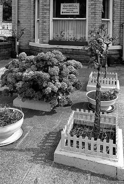
32r35: Roses with extra thorns, Beverley Rd, 1982 – Beverly Rd
19th May 2017
It should have been simple to locate where I took this picture as the sign on the wall clearly says it is Exmouth St, but finding he exact site of this shop 35 years later was still something of a problem. There are only around 10 corners where other roads meet with Exmouth St, a road parallel to and a few yards west of Newland Ave; not all have gables on them but those that do are of a similar age to this building – but none of them now look much like this.
Memory and a little logic led me to think that his was at the south end of the street and eventually this proved to be the case. The adverts for Smarties and Nescafe are on top of a ‘ghost sign’ which shows just the top of the letters, and MAR are fairly clear. Google’s StreetView is fortunately something of a time machine, and takes me back as far as 2009, when those advertisements have gone, and the crumbling letters below can just about be made out, showing the sign to read:
MARKET
ENGLISH
& FOREIGN
By 2009 the first floor window with its decorative moulding remained, but the ground floor had been remodelled and the brickwork covered with a white rendering. The small window above the shop doorway is lower, and there is a new window to the left of the door. The central window has become a second doorway and the left hand window replaced by a double window – and all three decorative mouldings about the ground floor windows and door have been lost.
Around the end of 2014 the wall changed again, losing the former shop door, the window above and the new window to the side and gaining a few inches of external insulation – which now covers the whole wall, with a cut-out still revealing the street sign, but the last decorative moulding above the top window disappears. The external insulation is a very sensible addition – we did the same with our gable end and it makes a great difference to our comfort and the heating bills, but the changes over the years have made the house rather blander.
The window display is dominated by cleaning products – Surf, Ajax and washing up liquid, while the door favours Corona soft drinks – with bottles, perhaps of them visible on a counter inside, and State Express 555. And inside the shop is a large plastic sack of what I think is coal, or rather some kind of solid smokeless fuel. It was an expensive way to buy fuel, but the only choice for those with small budgets on weekly pay and often limited storage space.
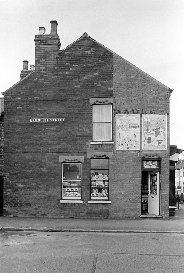
32r44: Exmouth St shop wall, Edgecumbe St corner, 1982 – Beverly Rd
20th May 2017
I can probably count the number of cat pictures I’ve taken on the fingers of one hand, or at most two, and several of these were in Hull, where our wider family for a short time included a visiting cat with a taste for fizzy wines. But I’ll spare you that.
Here we have a mysterious cat peering through the net curtains and the reflection of a house whose location is at least equally mysterious to me, somewhere in the Newland Avenue vicinity, possibly in Grafton St or Goddard Avenue.
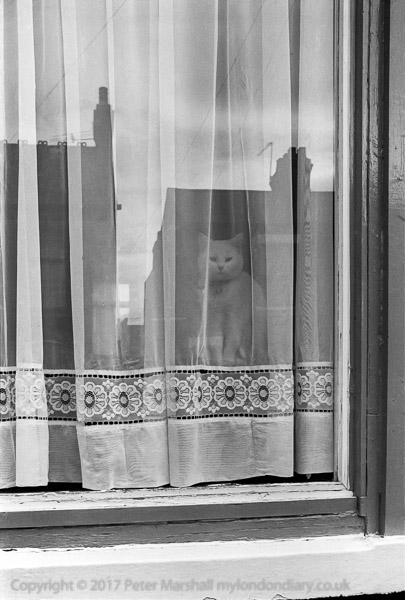
32r45: Cat in window, Newland Avenue area, 1982 – Beverly Rd
21st May 2017
Several of the streets between Newland Avenue and Beverley Road show some interesting variations in the treatment of doors,and other brickwork, and this was one example that particularly caught my eye, with its treatment of the two adjoining doors together under the same arch, and a motif in the gap between the rounded arches above the two doors and the slight pointed arch above that could almost be a mouth. Had I been using digital I would certainly have photographed more, but then every frame counted as it cost money I hardly had.
Clearly I framed it to just include the arches above the windows in the upper floor, and chose my position carefully with the 35mm shift lens to get the reflections of the two door arches opposite. At the right I included the sunburst patten over the door to the entry. I can’t remember why I chose to include the rather plain and boring bay and upper floor window at the right, but I suspect there may have been a car parked just out of frame at the left, and I possibly intended to crop the frame to a squarer format.
In 2015, student news site The Tab reported that Grafton St was the most dangerous street in Hull, with 225 crimes reported the previous academic year – more than one tenth of the total crimes in Hull over the period. Which is a pretty amazing record for a street less than 500 yards long. And it was this street that inspired The Beautiful South’s ‘The Rising of Grafton St’ on their second album – both former Housemartins Paul Heaton and Dave Hemingway were living in this ‘street of alcoholics and militant activists’ when they formed the group at No 70 in 1988.
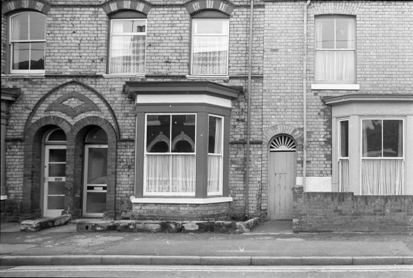
32r46: Houses and entry, Grafton St, 1982 – Beverly Rd
22nd May 2017
Two large pipes, on above the other formed a barrier along the edge of the dock wall east of the entrance to St Andrew’s Dock. Since they made their way across the dock entrance at the same level they were obviously only installed after the dock was closed in November 1975. I have no idea what the pipes carried, but it looked a rather temporary installation.
A couple of hundred yards east, roughly at the boundary between St Andrew’s Dock and William Wright Dock, the river wall turns to continue a few yards further north and there was a long wooden jetty. The pipes also took the turn and then disappeared from sight under the footpath.
The public footpath continues all the way to the centre of Hull, passing over the top of the new concrete buildings between the Albert Dock and Riverside Quay, built in the 1950s to replace the quay and its buildings destroyed by fire caused by bombing in May 1941. The burnt wooden jetties there were replaced by concrete, but a long area of wooden jetties remained at the west end of the docks.
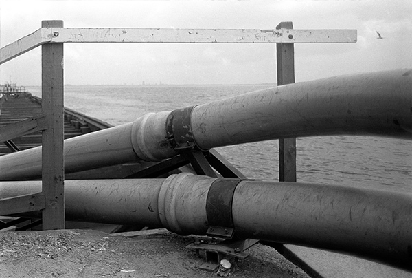
32t32: Pipes and River Humber, St Andrew’s Dock, 1982 – Docks<\small>
23rd May 2017
Just left of centre is my reflection taking this picture, which also shows the two large pipes along the river edge and beyond them the Humber and the Lincolnshire bank. A second person at right, watching me is my brother-in-law who although Hull born and raised had never visited the fish docks before I took him there on this occasion.
There was little left inside the building to suggest what it had been used for.
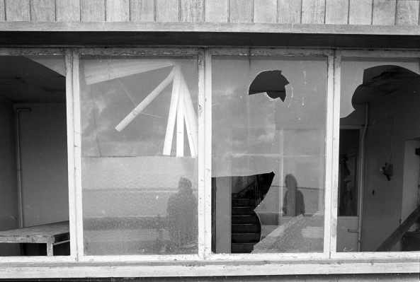
32t34: Disused Building, St Andrew’s Dock, 1982 – Docks<\small>
24th May 2017
The view looking roughly north-east across the swing bridge over St Andrew’s Dock Entrance towards the Lord Line building, with signs on it for British United Trawlers Ltd and Marconi Marine. Adjoining it to the right the offices of J Marr & Son. Although the dock was closed to shipping and the fishing fleet moved to Albert and William Wright docks seven years earlier there were still some offices in the area in use, with cars parked around the buildings.
The dock had opened in 1883, and was intended to be used to handle coal, but for almost all of its working life was the fish dock. It was extended in 1894. The extension is now a retail park, retaining the name St Andrew’s but with little else to recall its former use. There have been several plans for the redevelopment of the dock, most recently as a ‘Heritage Dock’. The scheme would retain the 1949 building for the Lord Line trawler fleet, and the Grade II listed Hydraulic Tower but little else other than the dock itself which would be refilled with water and converted to a marina.
The scheme seems a poor reflection of the heritage, at best half-hearted, when perhaps a more ambitious heritage attraction based on the fishing industry and retaining all existing buildings on the site including the stylish 1932 Hull Steam Trawlers Mutual Insurance Protecting Company building – as well as using a part of the dock area for several museum ships and boats – including Hull’s Arctic Corsair, now occasionally open as a museum on the River Hull – representing the different eras of the industry could succeed, if on a smaller scale than Hull’s major tourist attraction, The Deep. Albert Dock has the advantage of being only a few feet from the A63 Clive Sullivan Way, with good connections to the motorway system.
Marinas are not good earners, taking up considerable space and offering relatively little in return and are playgrounds for the rich rather than offering any real value to the city. Retaining much of the character of the former dock area does not require keeping the whole of the dock, and a more sensible scheme might involve a more intensive development of the western part of the former dock area.
In 1982, the dock still had some water in it, but it was filled (or silted up) later in the decade.
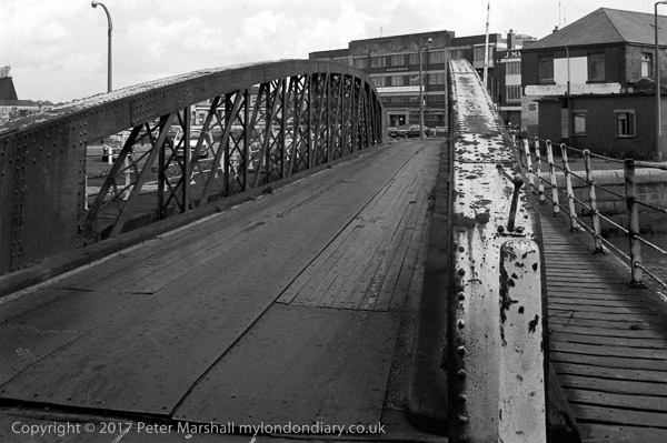
32t41: Swing Bridge over St Andrew’s Dock entrance and Lord Line building, 1982 – Docks
You can see the new pictures added each day at Hull Photos, and I post them with the short comments above on Facebook.
Comments and corrections to captions are welcome here or on Facebook.
______________________________________________________
There are no adverts on this site and it receives no sponsorship, and I like to keep it that way. But it does take a considerable amount of my time and thought, and if you enjoy reading it, a small donation – perhaps the cost of a beer – would be appreciated.
My London Diary : Buildings of London : River Lea/Lee Valley : London’s Industrial Heritage
All photographs on this and my other sites, unless otherwise stated, are taken by and copyright of Peter Marshall, and are available for reproduction or can be bought as prints.