21st July 2017
If it wasn’t for Sky Sports the Whalebone Inn would be a near-perfect pub. When I took these pictures it was a Tetley’s pub, which didn’t endear it to me, but it now has a good range of real ales. While the memorabilia make it something of a museum, so too apparently do some of the regulars. Back in 2010 writer and film-maker Dave Lee described it in his blog as “probably the city’s last remaining example of a true docker’s pub; it has traditionally been frequented by them and most of the current clientele seem to be former fishermen.”
I think the pub has gone through several phases of closure and internal reorganisation, but its exterior has seen relatively few changes. The blank wall at the left now sports a door and windows, that dreaded ‘Sky Sports’ banner was hanging there, and there are new notices including a new decorated large name board replacing the Tetley’s name sign across the frontage and the hanging pub sign with its sailing ship has gone.
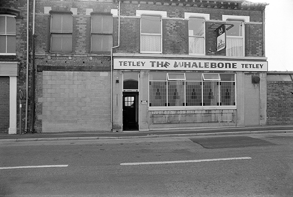
36g26: Whalebone Inn, Wincolmlee frontage, 1983 – River Hull
22nd July 2017
The first railway bridge on this site was built in 1853, to carry the Victoria or East Dock Railway over the River Hull. A single line bridge with speed and axle load restrictions it became inadequate to deal with the growing traffic to the Eastern docks as well as that going to Hornsea and Withernsea, and was replaced with a twin track bridge, with Hull Corporation paying the extra needed to provide a foot and cycle way along its north side. From 1864 it was also used by trains from Hull to Hornsea on the Hull and Hornsea Railway which diverted from the Victoria Dock Branch at Wilmington Station just to the east of the bridge.
This old footbridge and cycle path is now longer in use, instead there is a wider foot and cycle path where the trains used to run. When Dr Beeching shortsightedly axed much of our railway network, passenger trains to Hornsea and Withernsea stopped in 1964 but goods traffic on the Victoria Dock line continued until 1968. The Hornsea line was a useful route and well loved and could well have survived at least in parts as a light rail project; much is now a walking and cycling route.
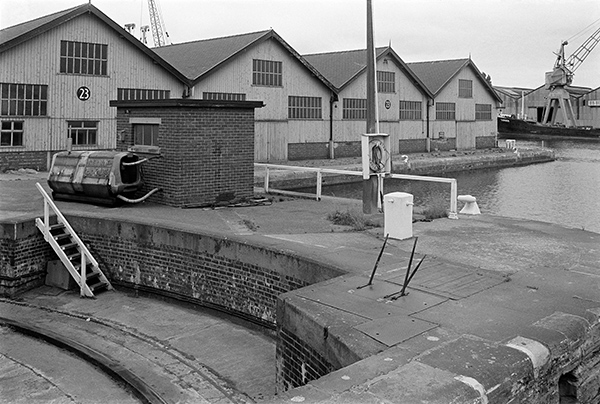
The bridge opened by rotating around a central axis under the operating cabin, powered by two powerful electric motors, with the electricity being supplied through high-level electrical cables. The bridge had a three-man crew – a mechanic and two steersmen with each motor having its own controls, and the system also required three manned signal boxes, one also serving the nearby Wilmington station. The 160 foot long bridge which weighs around 500 tons could be opened and closed in around 2 minutes. When open there was 53ft 6in of clear water to the west of the bridge and it had been designed so that a further river channel could if ever needed be dug on the east side allowing another 40ft of passage.
The Grade II listed bridge was restored in 1991 and the opening mechanism is said to be in full working order. It is one of 12 Hull bridges due to be opened (plus one long permanently open) in an event on the Autumn equinox creating “a symbolic wall denying the freedom of movement across the city” between East and West Hull as part of Hull 2017’s Freedom Season. The River Hull has always been a symbolic and physical divide between the two.
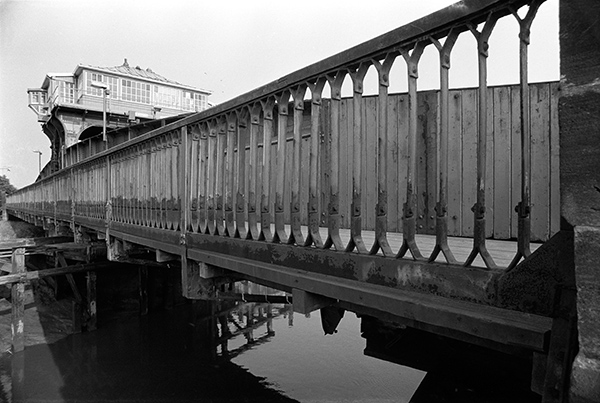
36g51: Wilmington Bridge, River Hull, 1983 – River Hull
23rd July 2017
J.A.Bell (Hull) Limited was incorporated on 10 Jan 1947 and later dissolved. A possibly related company, J A Bell II Ltd, also a general construction & civil engineering firm, was set up in Hull in 1993 and last submitted results in 2000. Without looking at records in Hull I can’t place it precisely, but I am convinced the building is no longer standing.
The picture was taken after I had photographed the Wilmington Swing Bridge and the next possibly identifiable pictures hows the premises of Enterprise Plastics Ltd – but Google tells me nothing about them. I think this was somewhere in the streets to the between Wincolmlee and the Beverley and Barmston drain. There seems to be a wild area at left of the house and some distant rooftops, but to the right is the builder’s yard. The high brick wall at its back has a ladder leaning against it from the other side and behind the parked car are some roof timbers for a building and a heap of sand.
Although the front door has been bricked up, there is a letter box in it, suggesting – as does the car – that the building was still be in use with an entrance at the side or rear.
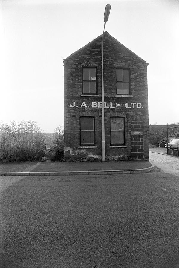
36g54: J.A.Bell (Hull) Ltd, Wincolmlee area, 1983 – River Hull
24th July 2017
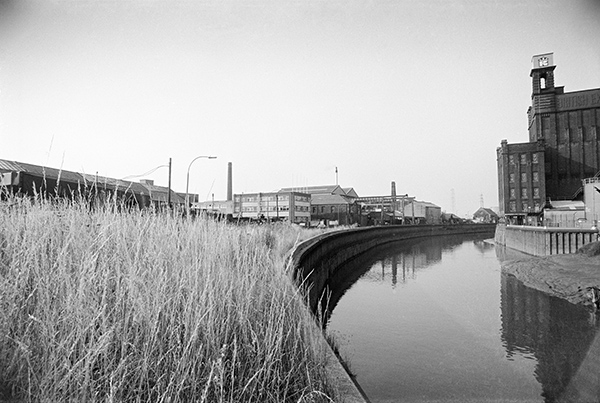
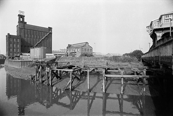
At the left of this image is the roof of the 1864 NER Sculcoates Goods Shed (Grade II listed six years after I took this picture) and in the distance the Sculcoates Tannery, established here on what was then called Church St by John Holmes who came from Doncaster around 1803. They later also had a larger works at Campbell St on Anlaby Rd, but the entire business moved to the site on Air St at the top of Wincolmlee in the 1930s. Now Holmes Halls (processors) Limited it was still tanning and dressing leather and dressing and dyeing fur on part of the site in 2016, along with the RE:GROUP recycling facility for oils etc. A few of the buildings remain, though the close more modern building, the taller factory and the brick chimneys have gone. Further along the bank, almost disappearing around the bend the small brick wharf-side building is still present on Bankside. On the right of the picture on the other bank of the river is one of Hull’s well-known mills, still standing – of which more in tomorrow’s picture.
This image was one of a series of five which together covering a 360 degree view from a position close to the end of the bridge. These were of course taken on film; in 1983 digital images hardly existed and were generally crude and pixillated – or even made up of ANSI characters, and I don’t think digital image stitching software existed as there was nothing for it to stitch. I intended not to produce a single panoramic image but a series of images that would be mounted in sequence with a small gap between them.
Making actual photographs join together before the days of digital stitching was a very tricky business, and would have needed rather move pictures, preferably taken with a longer lens, careful cutting of prints with a scalpel, shaving the edges and sticking them together with rubber cement, retouching with a brush and diluted black dyes and then rephotographing the whole. It was only really possible with very carefully taken images using standard or longer lenses.
These pictures were taken with an extreme wide angle – probably a 21mm lens – and the distortion inherent in rectilinear wide-angle images would have made accurate joining impossible.
It was easier to use a panoramic camera, but these were generally expensive – with some costing the price of a house in Hull – although cheap but limited Russian Horizon cameras became widely available in the 1990s. I bought a Japanese swing lens camera for around a month’s wages in 1990, but cameras of this type – first used with curved daguerreotype plates though mine took standard 35mm film – only cover an angle of view of a little over a third of a circle, not the full 360 degrees. Everything changes with digital, first of all with stitching software and then with cameras with panoramic modes – though I’ve never quite been able to get these to work adequately for anything except the web.
Photoshop will do a good job of joining any adjacent pair of these 5 images together but gives up on a third. But with dedicated stitching software I can join three of them. Possibly I could join all five, but since one of the missing others is almost entirely a section of stone wall and the other largely long grass I decided to stop at three. The result is an image roughly 15,000 by 4,000 pixels, a 3.75:1 aspect ratio that doesn’t display well on screen as a single image, but would print nicely at around 40 inches by 12 inches. But I will put it on-line in a smaller version later.
36g65: River Hull north of Wilmington Swing Bridge, 1983 – River Hull
25th July 2017
This was the next of the 5 images making a 360 degree panorama, and shows two of Hull’s listed buildings, the British Extracting Company Silo off Foster St at left and the Wilmington Swing Bridge at right. The silo at the oil extracting mill with the attached riverside receiving house was built in 1919, and designed with its interesting Baroque Revival detailing by architects Gelder & Kitchen of Hull, responsible for many of Hull’s finest buildings. It was listed Grade II ten years after I took this picture and is one of Hull’s most photographed buildings, both from the exterior and by urban explorers on the inside.
The company had bought the site which was a brickyard in 1915 and it had a rail link to the Hull Docks branch. The factory mainly produced margarine and cooking oils from rape, flax, linseed and other vegetable oil plants brought in by river and was a part of British Oil and Cake Mills. They also set up a soap factory adjoining this – Lever Brothers didn’t like the competition and bought up British Oil and Cake Mills in 1925, closing down the soap factory. The mill had been disused for over 10 years when I took this picture and was listed around ten years later. The company logo with a capital R and a crown was still clearly visible on the blue water tank in 1983, and the blue contrasted nicely with the long fire escape which was yellow (and I also photographed the building in colour and made a bad screen print of it.) The factory buildings to the right of the mill have all now been demolished.
36g66: River Hull, British Extracting Company and Wilmington Swing Bridge, 1983 – River Hull
26th July 2017
A few more from Goole.
Grab hopper dredger Goole Bight, built in 1958 at Yarwood & Sons in Northwich, 325 tons gross, was owned by the British Transport Docks Board which became Associated British Ports and was privatised in 1983. Sold to Humber Work Boats (Barton) Ltd in 2001 she became Abigail H. Unfortunately she sank at Heysham in 2008 and was scrapped at Ramsey Shipyard the following year.
The dredger used to work on a more or less daily basis to remove mud from inside Goole docks, which would then be dumped downstream at Goole Bight on the River Ouse, the sharp bend between Swinefleet Reach and Goole Reach around which ships have to go to reach the port. Dumping of mud is also allowed further downstream at Whitgift Bight.
There are several ships called Sabine, but this one is a Russian general cargo ship of 2,478 tons built in 1970 and still working, currently as I write in the Black Sea heading for Rostov-on-Don, rather a long way from her home port of St Petersburg.
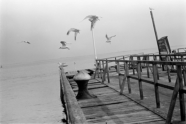
In the background you can see the two water towers, Goole’s famous ‘salt and pepper pot’. When I took the picture I had just come across a wide lock gate on a footpath and I think this must have been at Ocean Lock.
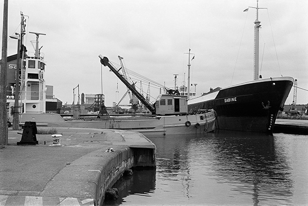
36h24: Goole Bight and Sabine in Goole Docks, 1983 – Goole
27th July 2017
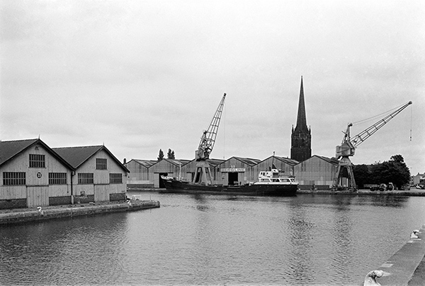
Goole’s two listed water towers, described in an earlier post, are here seen from the opposite side and a closer position. The slender brick tower from 1885 proved too small and was replaced by its fatter reinforced concrete neighbour in 1927. Both are Grade II listed.
Between the two is the spire of Goole’s Parish Church, St John the Evangelist in Church St, next to the docks and also Grade II listed. Built in 1843-48, architects William Hurst and W B Moffat it was paid for by the Aire and Calder Navigation Company.
The railway tracks are those leading to various parts of Goole Docks from the main line which was just behind me as I took this photograph, not far from a public footpath. The building at left is on the corner of Mariners St and Stanhope St and was the Lancashire and Yorkshire Railway Goods Offices.
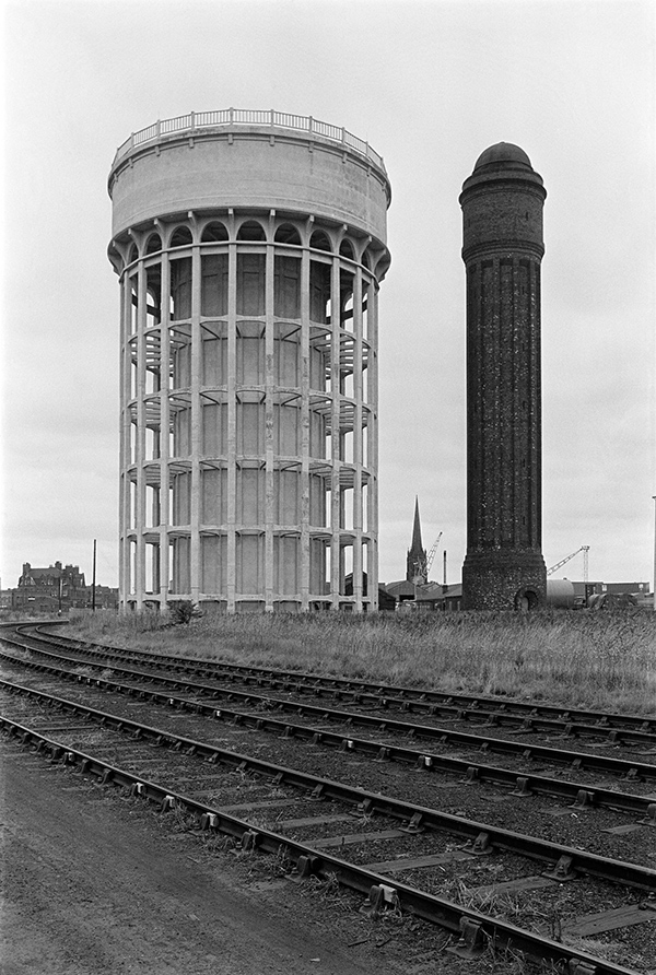
36h44: ‘Salt and Pepper Pot’ and Goole Parish Church, 1983 – Goole
You can see the new pictures added each day at Hull Photos, and I post them with the short comments above on Facebook.
Comments and corrections to captions are welcome here or on Facebook.
Continue reading Hull Photos: 21/7/17-27/7/17