12 January 2017
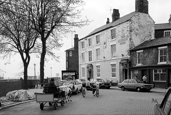
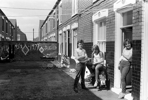
Subway St was the main route in and out of the Fish Dock for men and lorries and the subway led under the main railway line – and after this picture was taken, the A63 main route into Hull, Clive Sullivan Way. The shadows at the bottom of the image are from the chimneys of one of a number of fish smoking houses in the area, I think now all demolished.
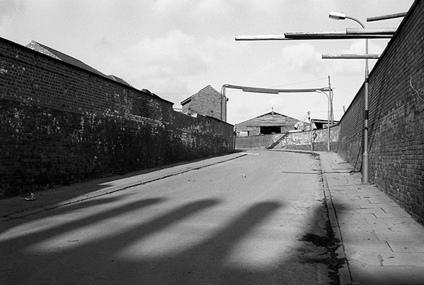
27p44: Subway St leading to St Andrew’s Dock, 1981 – Docks
13 January 2017
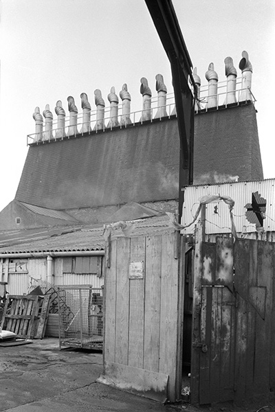
This fish smoke house was one of a number in the area close to where Subway St led into the Fish Dock – and probably this picture was taken either on West Dock Ave or Subway St close to their junction with Goulton St. Rows of chimneys like this on top of a steeply sloping roof were a familiar sight in the area between Hessle Rd and the Fish Dock.
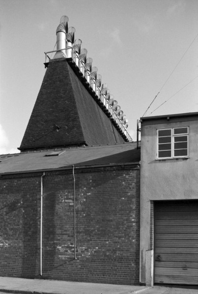
27p45: Fish Smoke House, Goulton St, 1981 – North & West Hull – Hessle Rd
14 January 2017
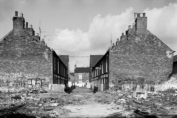
This is the image I chose for the cover of my book ‘Still Occupied’ and from my contact sheet it appears to have been taken in the Goulton St/Subway St area, although when I showed it in 1983 it was titled ‘Clearance area near Woodcock St‘, around 600m to the north-east. I’m afraid the exact location of some of my pictures is something of a mystery as I did an awful lot of wandering around while taking pictures.
Those more familiar than me with Hull may be able to identify the large curved roof in the right background, and below it, just in front of the houses a small obelisk on a plinth, though these details are probably too small to be seen clearly on the web image, and there are more monuments on a low mound in the centre of the picture, so this is definitely a burial ground. Just to the left of the post, partly obscured is a building which could be a pub.
Today, writing this, I spent a little more time researching this (thanks to Google Streetview), and the street at the left is definitely what is now called Conway Close, though when I took the picture it was Division Road. The mound and monuments are the Division Road burial ground – an overspill from Holy Trinity – and the houses at right are terraces from Tyne St. The buildings close to the post have I think all been demolished. The ‘Play Street’ I was on the edge of was I think Beecroft St or Massey St. The latter is still there with a ‘Play Street’ sign and the muddy area is now a grassed open space.
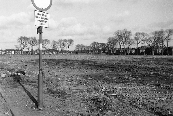
27p46: Play street and cleared site, 1981 – North & West Hull – Hessle Rd
15 January 2017
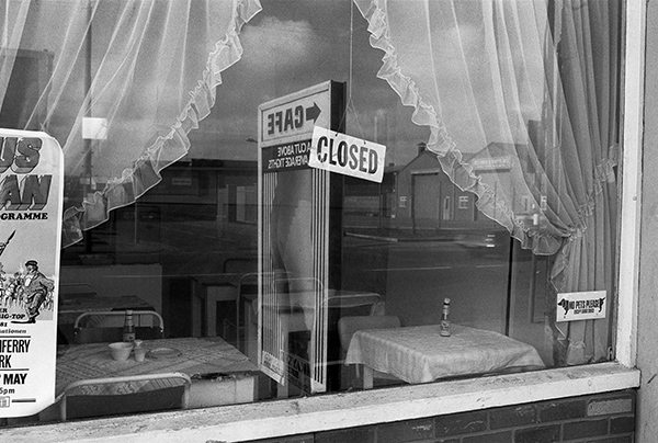
One of my favourite images from Hull, with its lively lettering and rather erratics letter heights in the sign-writing, the vase of daffs, one with a broken stem, and the patterning of the net curtain, the step and the frontage as a whole, which together I find rather satisfying. It was probably taken on a Sunday as there is a closed sign on the door.
I never went inside; like many working in Hull around noon I would rush back for dinner at ‘home’ before returning to work for the afternoon. My mother-in-law would put it on the table at 12.15 precisely. A friend who worked on Sculcoates Lane used to rush down to Paragon Station, jump on the train to Hessle for his home dinner his mother had waiting for him as he arrived, ate up and then rushed for the train back to Hull and a rather speedy return to the office.
It was about two and three-quarter miles from here to Loveridge Ave, and if I was lucky I might get the Fish Dock bus I think a 27. But otherwise I was then fairly young and fit, and at ‘scouts pace’ I might make it in 25 minutes. I daren’t be late.
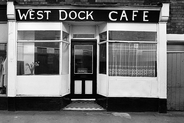
27p53: West Dock Cafe, West Dock Ave, 1981 – North & West Hull – Hessle Rd
16 January 2017
Another picture from West Dock Ave, a shop selling Norwegian jumpers for fishermen. There is a very straightforward and workmanlike look to the shop, with its boarding and simply set out display of four wooden forms showing off different jumper patterns. Presumably the others are in there bare as they only currently have four patterns.
You can still buy genuine Norwegian Merino wool jumpers, though probably not in West Dock Ave and the genuine article will cost you £150 or more. They use ‘raw’ wool which retains its natural lanolin and the fibres are spun along the fibre in a worsted weave rather than the normal wool weave across it. They are noted for warmth and breathability and have a natural water repellence due to a thick weave and the natural oil.
One of my brothers made several visits to Norway before his death when I was 20, and brought me back not a jumper, but thick woollen knitted socks. These were of oiled wool and came with the strict instruction – DO NOT WASH. But eventually they did need washing, or keeping in a different room.
Apparently you can then wash them with a little baby oil in the water to replace the natural oils. But I didn’t bother, and later relegated them to serve as bed socks, keeping my feet warm in winter and meaning I didn’t need to put on slippers when I got up in the middle of the night. I think they lasted well over 30 years.
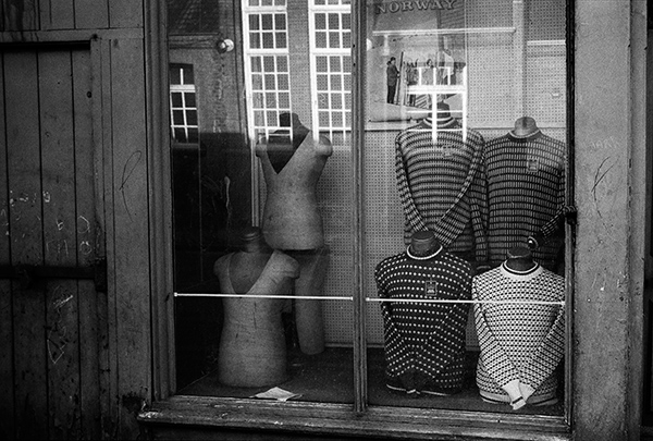
27p55: Norwegian jumpers, West Dock Ave, 1981 – North & West Hull – Hessle Rd
17 January 2017
It’s easy to place the picture of the shop window and the jumpers with some precision, as the reflection in the window shows it was taken opposite the school in West Dock Ave. This terrace is the next frame on the film, and I think was probably taken as I walked further south down West Dock Ave, and perhaps shows one of the terraces leading off east from Subway St – which would be the road behind the line of washing. But I could have wandered further, perhaps towards any of the three streets named after leading public schools, Rugby, Eton and Harrow presumably by some Victorian developer with a warped sense of humour.
Probably there are people in Hull who could remember having written their names on these walls, Tony, Kev, Mark, Dale and the others. Back in the days before spray cans graffiti was considerably more basic. And some years earlier another Tom, Sir Tom Courtenay, born in Subway St, lived at 29 Harrow St from the age of 4 in 1941 until 1959.
27p56: West Dock Avenue area, 1981 – North & West Hull – Hessle Rd
18 January 2017
Four months after taking the picture above I was back in Hull and went back to roughly the same area. St Mark’s Square is not the only thing that Hull has in common with Venice – it also has the parish and church of St Charles Borromeo, a sixteenth century Cardinal and administrator of the archdiocese of Milan which stretched from Geneva to Venice, and it used to have a great deal of water in the centre of the city, though rather less since Queens Dock was filled in as public gardens in the 1930s and a disturbing shopping centre plonked down on stilts in Princes Dock in 1990-1.
Hull’s St Mark’s Square is perhaps a little less imposing than its Venetian counterpart, but was at the centre of Hull’s first out of town suburban development by Thomas English, a wealthy local shipbuilder in the first decade of the nineteenth century known as the Pottery Ground. Edgar was one of his sons, and there is also an Alfred St, named after the other, as well or course as English St. Where St Mark came in I don’t know – there wasn’t a church there, though it did have a Wesleyan Chapel in the early years. St Mark’s Square was an open square for some years at the centre of the new development. All that remains from around 1802-3 appears to be the street pattern.
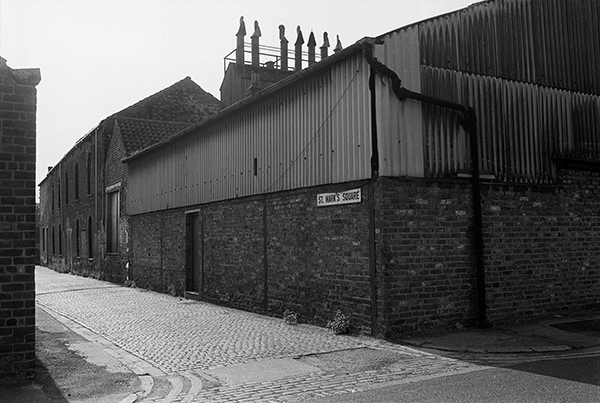
28h15: St Mark’s Square from Edgar St, 1981 – North & West Hull – Hessle Rd
And I turned my camera to portrait orientation for a second picture.
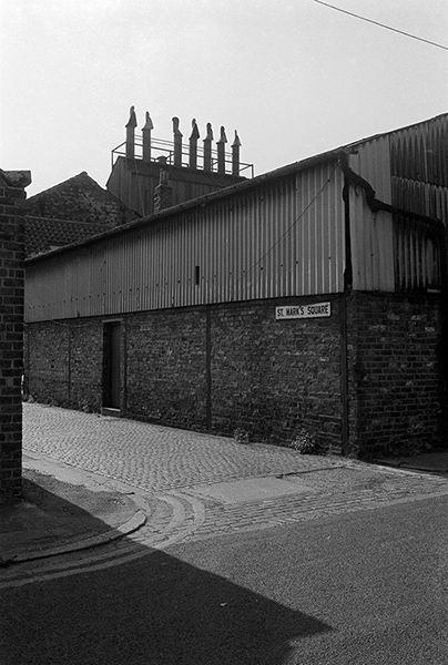
28h21: St Mark’s Square from Edgar St, 1981 – North & West Hull – Hessle Rd
You can see the new pictures added each day at Hull Photos, and I post them with the short comments above on Facebook.
Comments and corrections to captions are welcome here or on Facebook.
Continue reading Hull Photos 12/1/2017-18/1/2017