I’ve got rather behind on posting these digests from my image a day Hull2017 UK City of Culture project – too much happening elsewhere – though I have so far managed to post a new picture every day. Purists might object that some the more recent ones have been of Goole, but these are all of Hull. I’ll try and catch up over the next few days. As usual, comments and corrections on pictures and my text welcome.
15th June 2017
I have only the vaguest idea where this photograph was taken, but think it was somewhere on or near Charles St where considerable clearance was taking place for the building of Freetown Way which opened in 1986.
I was intrigued by the sun ray pattern of the sheets of material covering the window and the top half of the right hand door. There was what appeared to be an opening in section at the right of the window, which was now part covered by a strange structure of boards with four planks fixed on top, joined with gaps at the corners by metal straps.
It seemed too that the door had been fully covered, but the bottom section torn off, taking a little of the top too. It was all something of a puzzle, if inconsequential.
Though I also photographed this in colour where the oranges and yellows and red brick add to the impression of warmth and sun, I think I prefer the more austere pattern of this black and white image. I am currently scanning many of my colour images (there were around 40 in the 1983 Ferens show) though I haven’t yet managed to find all of those I took and will add some to the web site later.
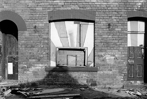
34g62: Property awaiting demolition in the Charles St area, 1983 – City Centre
16th June 2017
This was taken close to the railway line somewhere near the end of Gladstone St, and that the yard is probably now a part of the large car park between there and Argyle St, and where I was standing is probably now on the edge of the landing ground for the Air Ambulance helicopter. The tall modern building of Hull Royal Infirmary and the older building on the left with a chimney showing behind the right-hand tower indicate the location fairly precisely.
It was perhaps fortunate that the hospital was so close, as this was obviously a dangerous place, with the welcoming notice on the gate ‘KEEP OUT – ANYONE FOUND IN HERE WILL BE SHOT’ with a double underline under that last word. Usually Hull is a very friendly place and this came as something of a shock.
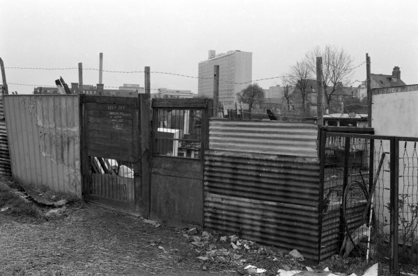
34h15: ‘KEEP OUT – ANYONE FOUND IN HERE WILL BE SHOT’, Gladstone St area, 1983- Argyle
17th June 2017
Ellerman’s Wilson Line ceased trading in 1973, ten years before I took this picture on Bishop Lane Staithe, reached through an archway from High St. The site has changed rather since I took this picture – the gates and the building to their left are gone completely and that at the back of the small enclosed yard has lost those small windows, replaced rather more and larger ones, nicely in keeping with the building, though some of the brickwork doesn’t quite fit in.
The stone plaque under the window at right seems rather worn and I can’t quite make out what it is from my picture. It appears to have a shield of some sort on it and the listing text says it has the date 1655, though the warehouse, now flats was rebuilt around 1800. The building in the centre of the picture is also I think listed and dates from 1829, but only the river and High Street frontage are of any visual interest.
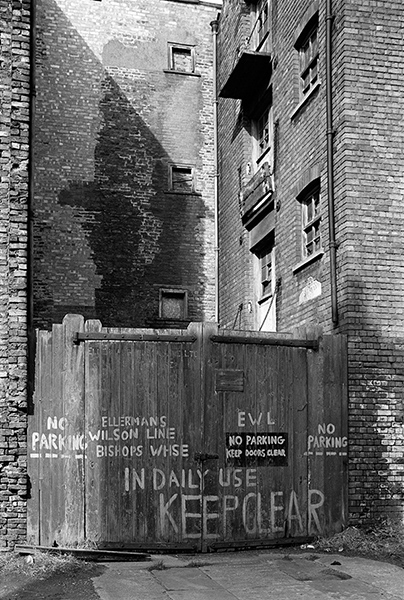
34h61: Ellermans Wilson Line Bishops Warehouse, 1983 – Old Town
18th June 2017
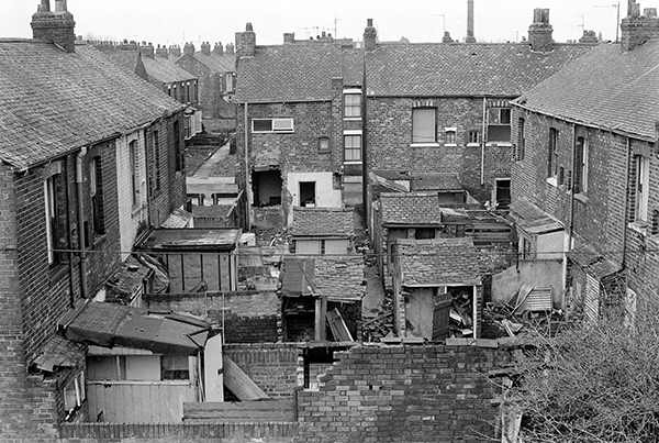
I took several pictures walking along the disused Hull Barnsley and West Riding Junction Railway and Dock Company (later it became the Hull & Barnsley) railway embankment which opened in 1885 which ran into Cannon St station, looking down onto the tightly packed terraces. Cannon St was Hull terminus of the Hull & Barnsley Railway, which was originally intended to run closer to the city centre to Charlotte St or Kingston Square, but the company ran out of money. It site on Cannon St is now occupied by the Motor Vehicle department of Hull College, and only some of its gates remain. The station closed in 1924 after the railway which had just been bought by its rival the NER ( North Eastern Railway) became part of the newly re-grouped LNER and all passenger services ran into Hull Paragon.
Although my contact sheets show the location Bridlington Avenue, a long and winding street that in part runs parallel to the former track, looking at maps from the era convinces me that these pictures were takin a little further north, looking down on the terraces off of Fleet St. This fits better with my contact sheet of the whole film which shows me before this photographing on Sculcoates Lane and afterwards going down Stepney Lane. Clinching the matter in the full size version above the rooftops at the left the dome of Beverley Rd Baths can be seen.
This was clearly a densely packed area about to be cleared, with virtually all properties empty and nothing that was there then remains. This and the few other pictures give a good impression of the dense packing of houses with the terrace system with each house having a small yard with an outside lavatory. A narrow alley in the middle of this picture led to the back gates to these yards. A second picture (click ‘Next’) shows the view from just a few feet to the right.
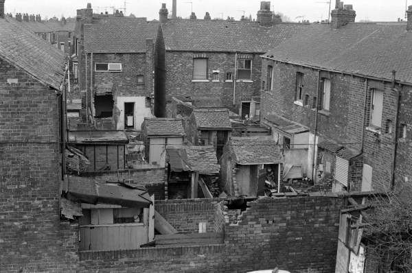
34i11: Fleet St and terraces from the Hull & Barnsley embankment, 1983 – Beverley Rd
34i26: Fleet St and terraces from the Hull & Barnsley embankment, 1983 – Beverley Rd
19th June 2017
Another picture from the disused Hull & Barnsley embankment, looking down along one of the terraces to Fleet St. Around half the houses in the terrace are already emptied and their ground floor bay windows covered with corrugated iron to prevent squatting.
Telephone wires run to virtually every house in the picture. Thanks to Hull Corporation running its own telephone system, almost every house had a telephone, though many of these would have been shared ‘party’ lines, where when you picked up the phone to make a call you would often hear your shared subscriber already using the line – and could either listen in or, as you were expected to do, put down the receiver and try again later. Local calls were untimed – and for 2p you could talk for hours, and people did. Some of those who grew up in Hull still do!
Along the bottom of the image is a typical railway fence with its close solid wood posts.
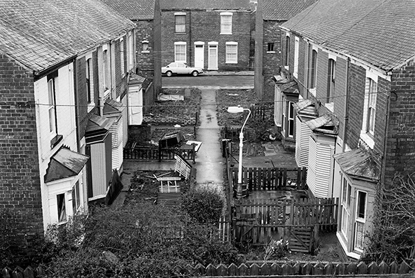
34i24: Fleet St and terraces from the Hull & Barnsley embankment, 1983 – Beverley Rd
20th June 2017
The off-licence is still there on the SW corner of Nicholson St and Sculcoates Lane, now calling itself Sculcoates News and no longer part of the Bass Charrington empire which no longer exists, selling off all its pubs in 1997.
That loyal flag celebrating the Queens Silver Jubilee is also long gone – and I think was already a little faded when I took the picture.
Also gone is the doorway at the left, but the rest of the surroundings remain more or less as they were in 1983, for a few hundred yards down Nicholson St, some of the streets off it and those to the north of Sculcoates Lane. Somewhere around here the Corporation bulldozers ran out of steam, though not before they had destroyed much that could have been better given new life rather than demolished.
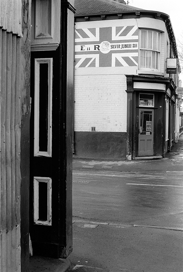
34i32: Off Licence, Nicholson St corner of Sculcoates Lane, 1983- Beverley
21st June 2017
I think that this blocked up window was next to the site of the railway bridge which carried the old Hull & Barnsley Railway across Sculcoates Lane. I can’t remember for sure if that bridge was still there in 1983, and can find no record of when it was demolished. Although passenger traffic on this branch to Cannon St ended in 1924, the line was only closed for goods in 1968, and the bridge was still there when I first walked along this road in the early 1970s.
Certainly the embankment leading to the bridge was still there – and I think is what can be seen on the right of this frame. Later much of it was removed to make a gentle slope up from the road.
Later the embankment was removed on both sides of Sculcoates Lane, probably to make the former rail line more accessible to pedestrians and cyclists.
I’ve no real idea either what kind of ‘REPAIRS’ once went on inside these premises, which look like a later single storey addition to a larger building which can be glimpsed at top left, in what looks like older and less regular brick. Memory, so often fallible, suggests it was a cobbler.
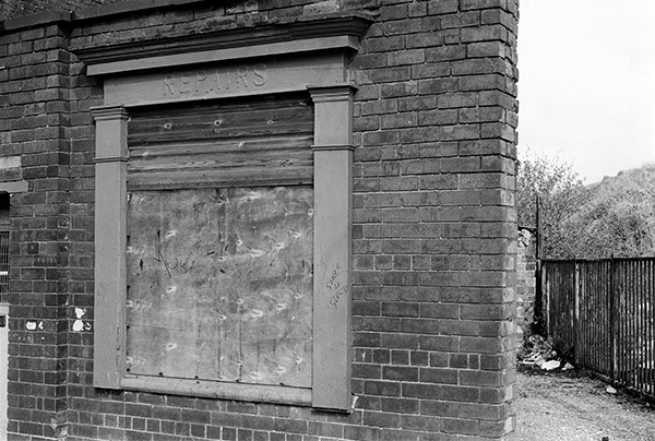
34i35: Repairs, Sculcoates Lane area, 1983 – Beverley
You can see the new pictures added each day at Hull Photos, and I post them with the short comments above on Facebook.
Comments and corrections to captions are welcome here or on Facebook.
______________________________________________________
There are no adverts on this site and it receives no sponsorship, and I like to keep it that way. But it does take a considerable amount of my time and thought, and if you enjoy reading it, a small donation – perhaps the cost of a beer – would be appreciated.
My London Diary : Buildings of London : River Lea/Lee Valley : London’s Industrial Heritage
All photographs on this and my other sites, unless otherwise stated, are taken by and copyright of Peter Marshall, and are available for reproduction or can be bought as prints.