I meant to point out last week that Carl de Keyser has been answering questions on David Alan Harvey‘s ‘Burn‘, “an evolving journal for emerging photographers.” Some of the comments make interesting reading, though of course not everyone has “Two assistants in Magnum/Paris” who ” go around the entire European coastline on Google earth and put flags in places where they think I might find an interesting situation to photograph that reflects that idea of waiting for the big one.”
I’ve written about de Keyser’s work on several occasions and as well as on Magnum you can also see more on his own web site, and on the site devoted to his latest project Moments Before the Flood, involving the whole European coastline.
He is currently working in the UK, and on the site you can see his images from a number of places I’ve also photographed, including Hornsea, Withernsea and Skipsea, and I see that on Saturday he was in Brighton, photographing its derelict West Pier. Pictures are going up more or less as soon as they are taken and comments are welcome on the site.
Although I admire his photography, and there are plenty of good pictures, I’m not sure that I think that the project is really quite coming together, though I’ve only looked through the 80 or so pictures from the UK. It’s perhaps just a little too scenic (and in one or two cases too picture postcard) although of course the editing may well sort that out.
But sometimes looking at his pictures I do get the impression of a man in a hurry driven by a huge mission to complete, and driving at great speed from ‘flag’ to ‘flag’ around our coastline.
Hornsea, Skipsea and Withernsea particularly interested me because I’ve visited them quite a few times over the years (of course I’ve also been to many of the other places around the coast) and have photographed the effects of erosion there and along the whole Holderness coast. But I think I took my best pictures when I used a bicycle to get around, there is a lot to be said for working at a slower speed.
But Google Earth and Google Streetview and other mapping and satellite image services have very much changed the way we can look for subject matter.
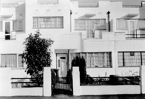
I had a query yesterday about a picture I took in 1995 in London (its on the Buildings of London site I wrote in 1996 and have hardly updated.)

(Sorry it’s not a great scan, but technology back then was relatively primitive.)
Of course I could go back to my contact sheets from 1995 and find the image, and fortunately I had put down the details and was able to confirm that the street I’d given was correct. It also had a six figure grid reference, but that only locates it to roughly a hundred metres. Rather than just check on the map, I started with finding the street on Google Earth then used ‘Street View.’ And it wasn’t there – which is why I’d had the query.
Fortunately one of the other frames I had of the building showed the right hand corner where there was a street with a name I could read with a magnifying glass from the contact sheet, so I could tell exactly where it had been. Back to street view and I could also clearly identify the very dull red brick block that had replaced a rather interesting piece of 1930’s architecture.
Of course the new block has an extra storey and almost certainly made a decent profit by fitting more units into the same space. And probably the new building will be more energy efficient and with luck the roof won’t leak, often a problem with ‘modern’ buildings that were really designed with warmer drier climates in mind.
If I was in power I would insist that any new building that replaced an old one had to be at least as architecturally distinguished. But our planning system has little control over visual aspects of building, as you can see on almost any walk through London.