Although my year of daily posts throughout Hull’s year as City of Culture has ended, I will continue to add pictures to my Hull Photos site, just not one every day. I do have quite a few black and white images still to digitise and add, as well as some in colour. Instead of daily posts I will try to make roughly weekly posts of small groups of images – and will post about them here and put a link to these posts on my Facebook page.
This is the final digest of my daily posts during Hull2017 on Facebook, about the pictures added daily on the intro page at Hull Photos, and includes nine images to go to the end of 2017. Comments and corrections to the captions and texts about the pictures are always welcome here or on Facebook.
Hull Photos
23rd December
Victoria dock was something of a wasteland in 1985, fifteen years after it closed as a dock in 1970. It was bought by Hull Council in 1987 and development began in 1988, though it was slow to be completed. The new primary school was only completed in 1999 (the first PFI school in the country) and they have never really got around to building much in the way of shops etc in what is now called Victoria Dock Village (or the South Hull Estate.)
The KC Kingston Contractors Ltd truck has the address Galatea Buildings, South East Victoria Dock, Hull, and the building at right may well be a part of those buildings, though clearly it had seen better days. In Greek mythology, Galatea was a sea nymph or Nereid who the Cyclops Polyphemus fell in love with, but she spurned him as she loved Acis. When Polyphemus saw the two of them together he crushed Acis with a boulder. The distraught Galatea then transformed Acis into a stream. Galatea’s name means ‘goddess of calm seas’ and so has often been used as a name for ships.
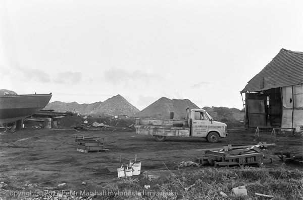
85-10m-32: Victoria Dock, 1985 – Docks
24th December
Railway lines somewhere on Victoria Dock, which once had an incredibly extensive rail system serving its timber sheds and yards, all leading out to the LNER Victoria Dock Branch.
The shed in the distance is the one in the previous picture. It was probably taken in the afternoon looking roughly south west, with the sun just out of frame but giving the ray across the image
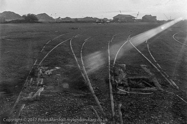
85-10m-35: Victoria Dock, 1985- Docks
25th December
This was taken just a few feet away from the the previous image (actually made after this one) but looking in the opposite direction, so the sun was now behind me.
The chimneys and house roofs are those of properties on of close to the Hedon Rd, with the block at the centre of the picture probably what is now Trinity Hotel more or less on the corner of Wyke St.
The fence with streetlights is Earle’s Road and the fence is the boundary of the Victoria Dock estate. The area with the open timber sheds and the other large buildings is now the Portside Business Park, though I think all the buildings have been replaced by more modern metal sheds. Where I was standing to take this is now roughly at the roundabout where South Bridge Road meets Corinthian Way on the Victoria Dock Estate.
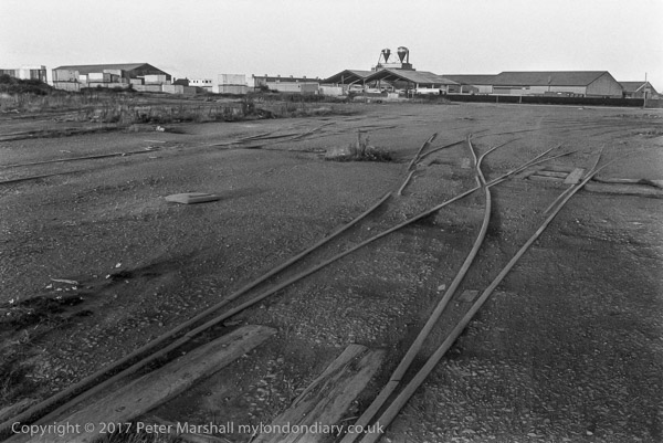
85-10m-33: Victoria Dock, 1985- Docks
26th December
A tarmac road and a wooden fence, probably on one border of the dock with a rather temporary looking building behind. The fence looks like many of those along the edge of railway properties. This was taken on my way out of Victoria Dock on Earle’s Road.
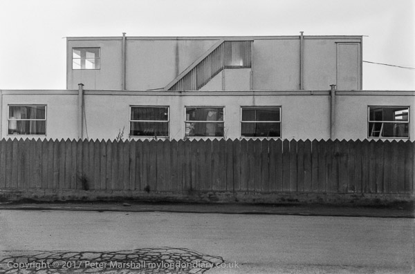
85-10m-36: Earle’s Road, Victoria Dock, 1985 – Docks
27th December
Boat and industrial buildings on Victoria Docks. The name on the roof, Telstar was probably for Telstar Caravans Ltd. The name was popular after the launch of Telstar 1 in 1962, which was the first communications satellite for TV and telephone signals, and was used as the name for a chart-topping instrumental by the English band Joe Meek for the the Tornados.
These buildings were just south of South Bridge Road to the west of the Half Tide Basin.
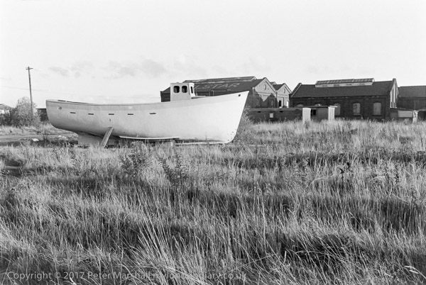
85-10m-42: Victoria Dock, 1985 – Docks
28th December
The view taken from the north side of the Half Tide Basin looking towards the two entrance locks from the River Humber. The dock has silted up and is overgrown in parts with grass and reeds.
The structure just to the left of the Wilson building had the name of the dock on the side facing the Humber. To the left of the two locks (the one on the right a smaller lock to enable barges to leave at any state of the tide without a great loss of water) is the Watch House.
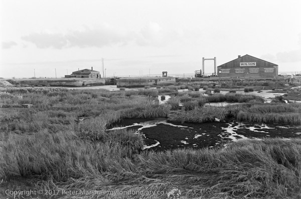
85-10m-43: Half Tide Basin, Victoria Dock, 1985 – Docks
29th December
This bridge took South Bridge Road and the railway lines across the entrance look from the Half Tide Basin to Victoria Dock.
It seems a shame that only a single building (a pumping house at the top of the patent slip a little to the west of this bridge, currently being converted into expensive flats) was retained when the docks were converted to a housing estate. Substantial building such as this brick structure would have retained some of the character of the area and its history, and could almost certainly have been converted to some new use without damaging its appearance. From the vehicles parked further along the road the building appears still to have been in use.
The swing bridge was built in 1849 for the opening of the dock by Beecroft, Butler & Co., of Kirkstall Forge, Leeds, and the Haigh Foundry Co. of Wigan and was fortunately still there to be listed in 1994, nine years after I photographed it.
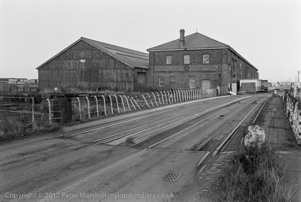
85-10m-45: Bridge across Victoria Dock Entrance from Half Tide Basin, 1985 – Docks
30th December
The view from the swing bridge looking towards the entrance locks from the Humber, showing the heavily silted Half Tide Basin. The tidal flow in and out of the Humber brings in mud, which settles in the still water.
When in use the Half Tide Basin will have required constant dredging, and after it closed it quickly silted up. When neighbouring Alexandra Dock was built this took a water supply from the Holderness Drain to reduce silting. The Half Tide Basin was dug out or dredged as a part of the development of the area, and the entrance from the Humber sealed off to prevent it filling up again. There were plans to redevelop it as a marina, but they was found to be too expensive. The basin was used for some theatrical performances during Hull’s year as UK City of Culture.
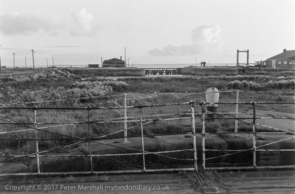
85-10m-46: Half Tide Basin, from swing bridge across Victoria Dock Entrance, 1985 – Docks
31st December
These lights, or rather their very similar modern replacement are still there on Sammy’s Point where the River Hull flows into the Humber, though the area around them has changed completely. The grass has been replace by a paved walkway with railings at a slightly higher level which now leads around the bulk of The Deep, and there are a series of boxes around the base of the light, and a lower array of cross-shaped lights. The two upper lights can show a red or green light and the lowest is either red of white.
Signs pointing both left and right now indicate rather pointlessy that you are on the Trans Pennine trail – your only other option being to jump into the river, and by the side of the rather more neat fence are floodlights for The Deep.
Sammy’s point gets its name from the shipyard set up here by Martin Samuelson in 1857 and was said to be the largest shipbuilder in the country a couple of years later, with 97 vessels, mainly steamships, being built in the yard by the time he sold the works to the Humber Ironworks and Shipbuilding Company.
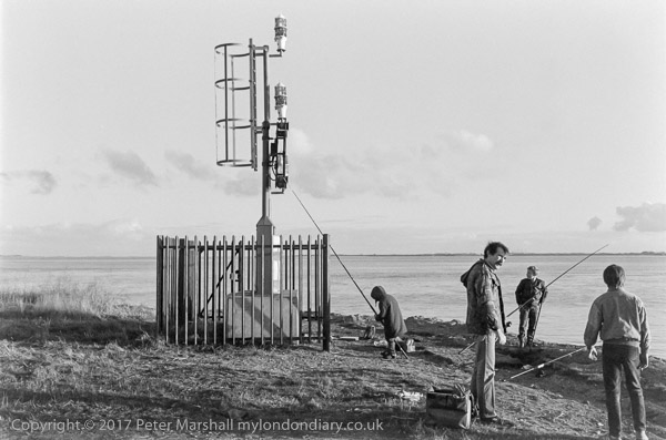
85-10m-51: Sammy’s Point light, 1985 – Humber
The above image, posted on December 31st, 2017 completes my year of daily posts for Hull2017 to Hull Photos, with my short comments on Facebook.
Comments and corrections to the captions of any images on the site are still welcome on the posts here or to me on Facebook.
Although the year-long project has ended Hull Photos will continue to grow and I will make occasional posts about the new images added here and on Facebook.
______________________________________________________
There are no adverts on this site and it receives no sponsorship, and I like to keep it that way. But it does take a considerable amount of my time and thought, and if you enjoy reading it, a small donation – perhaps the cost of a beer – would be appreciated.
My London Diary : Buildings of London : River Lea/Lee Valley : London’s Industrial Heritage
All photographs on this and my other sites, unless otherwise stated, are taken by and copyright of Peter Marshall, and are available for reproduction or can be bought as prints.