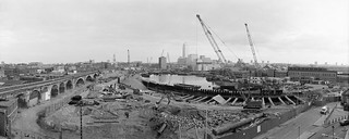
My walk down the Lea Valley from the source to the Thames took a long time on my posts here, and there are still many pictures in the Flickr album that have not featured here, including those around the other outlet from the Lea Navigation to the River Thames via the Limehouse Cut and Limehouse Basin by which barges could avoid the winding and rather treacherous Bow Creek. There are over 500 pictures in the album, including a number of colour images and they come from various visits over around ten years when I probably made several thousands of exposures. And I continued to make occasional visits there after 1992, the latest I think in 2018 or 2019. So here are just a couple of final images before I return to my wider explorations of London, back in 1987.

1987 continued

My last post about my pictures around London several months ago ended with two pictures from Pimlico taken in early October, and that’s where I will take up the story. The long streets of the area lined with Cubitt’s impressive stucco were developed from 1825, St George’s Drive, along with Belgrave Road were the two principla streets, with these opulent five storey town houses, were built (as Wikipedia quotes) for “professional men… not rich enough to luxuriate in Belgravia proper, but rich enough to live in private houses”.
By the 1980s many houses in the area were beginning to show their age; some had been converted to hotels and others offices, while others were in multiple occupation, often rather crudely converted. Developers were busy buying up properties to convert them into flats, as this picture with its estate agent’s boards and scaffolding illustrates.

The side streets were also a part of Cubitt’s development, but here the houses were less grand and typically of three storeys.
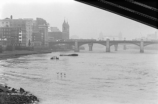
My next visit to London, later in the month took me further east, walking from Waterloo Station to the City meant I had to cross the River Thames and this picture shows a rather misty view downstream, with Southwark Bridge, Cannon St Rail Bridge, London Bridge and Tower Bridge. At the left is a tall warehouse on the upstream side of Queenhithe, London’s earliest dock. Now there would be another bridge, the Millennium footbridge, in the foreground.
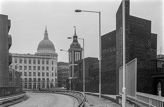
White Lion Hill leads up from the river to Queen Victoria St, where a rather dull office building, the Faraday Building, seems to have the dome of St Paul’s Cathedral on its roof. This part of the building was built in 1890 as a post office sorting office, which in 1905 became the GPO’s first London telephone exchange. A taller extension to the west (to the left of this view) was added in 1933, with the whole complex becoming known as Faraday House. This held the international telephone exchange and in its first years virtually all the world’s international telephone conversations were routed through here.
As this picture shows, Faraday House partly blocked the view of St Paul’s Cathedral from the Thames riverside and this led to the introduction of regulations restricting the height of new buildings in various locations giving a number of protected views from around London – including a well known one from Richmond Park. But the regulations only came in after Faraday House was built and were not retrospective. The photograph also shows another of Wren’s churches, St. Benet Paul’s Wharf, rebuilt after the Great Fire and reopened in 1683. Queen Victoria granted the church to Welsh Anglicans in 1879 and services are still conducted there in Welsh.

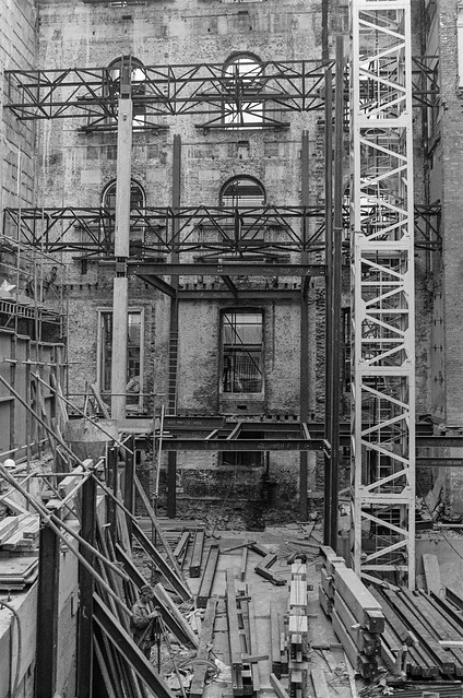
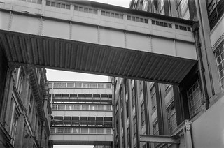
Redevelopment was in full swing in the Knightrider St area as you can see from these pictures. I think the building at right is is the back of the building on Queen Victoria St now home to the Church of Scientology, and to the left is probably Faraday House. So many of what see like older buildings in the city are now just facades to more recent developments.
The web has many references to Knightrider St, but none that give useful information about its post-war past. Most are about its name, suggesting that Stow’s suggestion it came from being a handy route for knights riding to St Paul’s and Smithfield is unlikely (though there are no positive suggestions), or list buildings along the street which were demolished in the nineteenth century or earlier, and exactly the same information is in those reference books I’ve consulted which mention the street.
Addle Hill which runs down to the western end of Knightrider St, which continues west as Wardrobe Terrace. In between taking these pictures I photographed The Bell pub, on the corner of Addle Hill and Wardrobe Terrace which closed in 1989 and was demolished in 1998, one of many pictures not on-line. Further east on Knightrider St is The Horn Tavern, which was renamed The Centre Page in 2002 and is newspaper-themed.
These pictures are from Page 7 of my album 1987 London Photos.
All photographs on this and my other sites, unless otherwise stated, are taken by and copyright of Peter Marshall, and are available for reproduction or can be bought as prints.
Tags: bridges, facade, Knightrider St, Limehouse, Limehouse Basin, London, Pimlico, redevelopment, River Thames