Another wet day, and as there wasn’t a great deal happening that I wanted to photograph and no one had offered to pay me to photograph it, I stayed in and kept my cameras dry. Which gave me a chance to catch up on something I’d started a couple of times before but never found time to finish, a significant update on my web site on the River Lea.
Back when I started photographing it around 1980, the Lea was virtually an unknown river. Quite a few Londoners would have heard of it, but I think relatively few could have told you exactly where it ran and even fewer would have actually gone to see it. Now, with the 2012 London Olympics being held on a bit of it at Stratford Marsh, it’s a tourist attraction, and if I go there I have to dodge crowds of tourists being taken along the Greenway by Blue Guides.
Of course they won’t see what I saw then:
This was a view of the Olympic site in 1990. Now it looks rather different. And the Pudding Mill River which ran alongside Pudding Mill Lane is no longer visible:

And the footbridge provided by Major Villiers for the school children of Hackney Wick to get across the Navigation to their playing fields was removed last year; the flats were dynamited years ago:

As you can see, I didn’t quite get around to trimming the scans – I did several hundred scans for the presentation I gave at the London International Documentary Festival, and not surprising was rather pressed for time. Quite a few are in need of some spotting and retouching too, time has not been kind to some of these negatives.
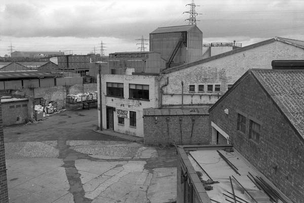
Of course the Olympic site isn’t the only part of the Lea that has changed since then:

Bow Creek is still there, but not much else. The power station and flood barrier are both long gone. But my favourite images are still of something else that is lost, the timber yards. There are three from Dorford Wharf in Edmonton that I particularly like – this is one:

When I took these pictures I wasn’t much into taking notes, and it was of course long before we had GPS. I could remember where I took every picture and what it showed without much trouble then, but 25 years later it is not so easy. Later I got into the habit of writing significant information onto the contact sheets – things like the grid reference and street name, as well as carrying a little black book where I’d record stuff.
Later I moved to making the field recordings on a miniature tape recorder and filling in the book at home, as the writing I did on the street wasn’t always too legible. This did used to make me feel rather embarrassed as I stood in the street apparently talking to myself, but now we have mobile phones most people seem to do it most of the time.
The site the work is on is of course The Lea Valley, and if you want to go directly to the page with the stuff I’ve been talking about it is Black and white images 1980-92.
If you find anything you know I’ve captioned wrongly please let me know. And I confidently expect to get get more e-mails about this picture of the source of the River Lea asking me if I’ve noticed , er, that man is, er…

And I didn’t set it up, unless just going there with a French photographer counts.