Posts Tagged ‘DLR’

West India Docks 1988 (2)

Saturday, November 13th, 2021

SS Robin, South Dock, Tower Hamlets, 1988 88-6b-44-positive_2400
SS Robin, South Dock, Tower Hamlets, 1988 88-6b-44

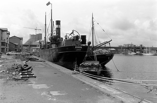
SS Robin is a 350 gross ton steam coaster built by Mackenzie, MacAlpine & Co at their Orchard House Yard in Bow Creek in 1890 and the only complete Victorian steam ship in existence. She still has the original steam engine fitted in Dundee by Gourlay Brothers & Co.

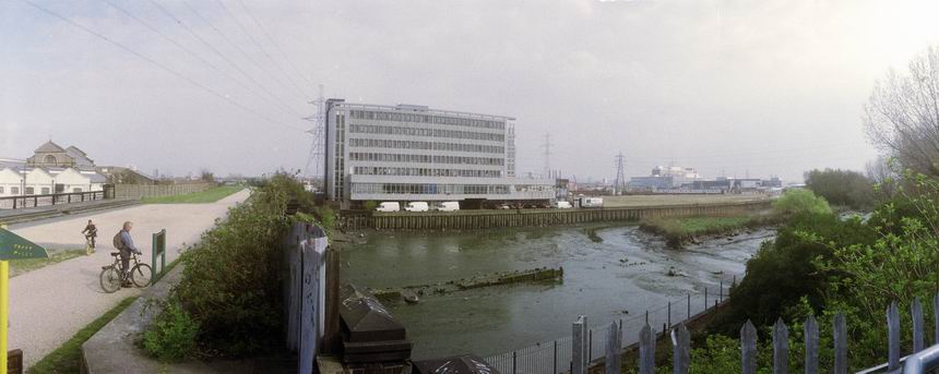
In 1900 she was renamed Maria and spent the next 74 years working around Spain for several Spanish owners, and in 1966 some extensive alterations were made. When about to be scrapped in 1974 she was bought by the Maritime Trust, her original name restored and treated to an extensive restoration in Rochester before coming to St Katharine’s Docks in London and opened to the public as a part of their Historic Ships Collection. After this closed in 1986, along with several other vessels from the collection Robin was laid up here in the West India Docks. You can see the stern of the Yarmouth Steam Drifter Lydia Eva at the right.

In 2000 Robin was sold for £1 and later the SS Robin Trust was set up to restore the vessel, an expensive and lengthy process and eventually it was decided necessary to put the vessel on a pontoon. The SS Robin museum, theatre and educational centre is now in the Royal Victoria Dock.

DLR, BT, Quay House, Admirals Way, South Quay, Tower Hamlets, 198888-6b-45-positive_2400
DLR, BT, Quay House, Admirals Way, South Quay, Tower Hamlets, 1988 88-6b-45

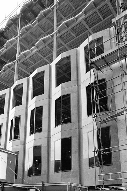
Quay House, a three storey office block built in 1986-7 was occupied by BT. Empty for some years, planning permission was obtained in 2020 for the 40-storey Quay House waterfront development including a 400-bedroom hotel and 279 serviced apartments alongside dockside leisure facilities.

South Dock, Heron Quays, Marsh Wall, Tower Hamlets, 1988  88-6b-46-positive_2400
South Dock, Heron Quays, Marsh Wall, Tower Hamlets, 1988 88-6b-46

The Survey of London describes these low rise buildings as “high-tech ‘cabins’ or ‘Swiss chalets’, with light steel structures, covered with red, purple and blue-grey vitreous enamel panels, while the monopitch roofs are clad in aluminium” and says they were part of a large scheme for the area begun in 1981 and built in 1984-9.

I think this is now the site of 1 Bank Street, a 28 floor office block completed in 2019.

BT, South Dock, Admirals Way, South Quay, Tower Hamlets, 1988  88-6b-31-positive_2400
BT, South Dock, Admirals Way, South Quay, Tower Hamlets, 1988 88-6b-31

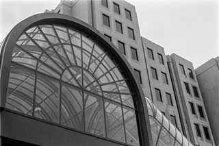
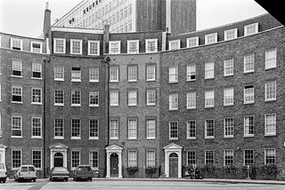
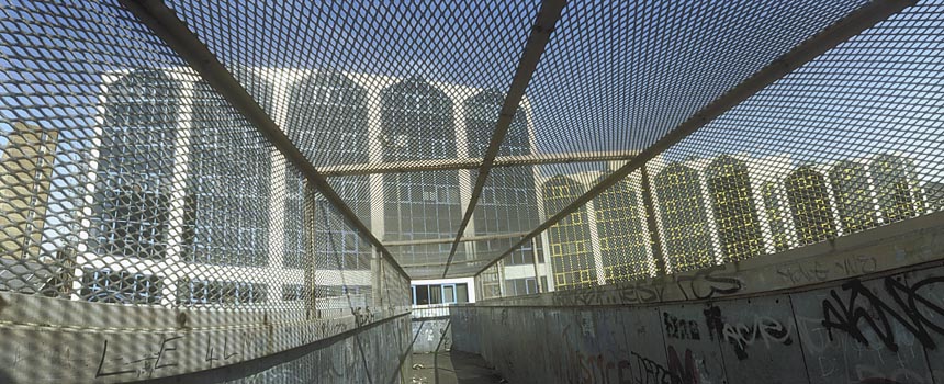
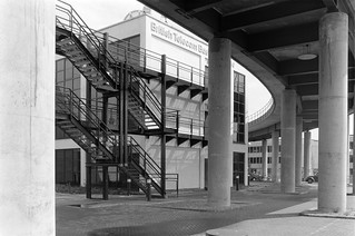
The front of the BT Business Centre on South Dock.

DLR, South Dock, Admirals Way, South Quay, Tower Hamlets, 1988  88-6b-32-positive_2400
DLR, South Dock, Admirals Way, South Quay, Tower Hamlets, 1988 88-6b-32

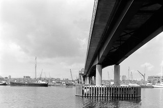
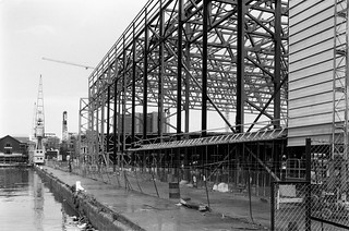
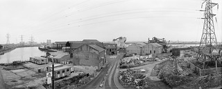
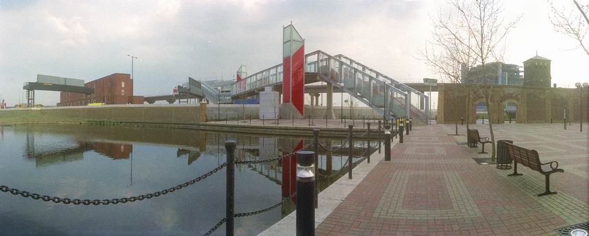
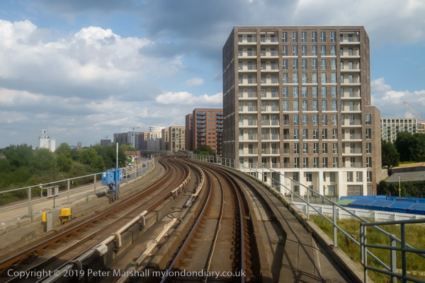
Taken from more or less the same place as the previous picture and that below, this is where the DLR crosses the South Dock of the West India Docks, looking towards Heron Quays station. It shows how little development there was here in 1988.

DLR, BT, South Dock, Admirals Way, South Quay, Tower Hamlets, 1988 88-6b-33-positive_2400
DLR, BT, South Dock, Admirals Way, South Quay, Tower Hamlets, 1988 88-6b-33

Looking back at the curve of the DLR around Quay house towards Marsh Wall.

London River Man, John W Mills, sculpture, Ensign House, Marsh Wall, Tower Hamlets, 1988 88-6b-35-positive_2400
London River Man, John W Mills, sculpture, Ensign House, Marsh Wall, Tower Hamlets, 1988 88-6b-35

London River ManJohn W Mills ARCA FRBS 1987. This sculpture salutes all London river workers – toshers – bargees – dockers – ale tasters – coalheavers – ferrymen” and is rather hidden now on Marsh Wall. It is rather less than lifesize. John Mills (b1933) is better known for his Whitehall memorial to the women of World War II.

Admirals Way,  South Dock,  South Quay, Tower Hamlets 88-6b-36-positive_2400
Admirals Way, South Dock, South Quay, Tower Hamlets 88-6b-36

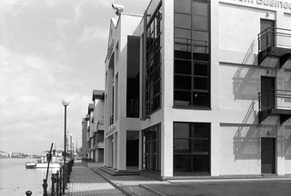
This is Waterside, where these buildings, described as small-business apartments were built in 1985-6. They are still there, looking much the same, though probably for not much longer.

BT,  Admirals Way, South Quay, Tower Hamlets, 1988  88-6b-21-positive_2400
BT, Admirals Way, South Quay, Tower Hamlets, 1988 88-6b-21

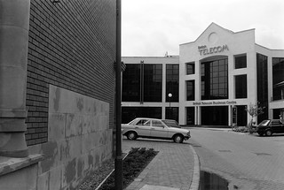
A final picture of the British Telecom Business Centre – and what was presumably its main entrance.

More from around the West India Docks in a later post. Click on any of the pictures to see larger versions of any of them in the album 1988 London Photos from where you can browse other images.


West India Docks 1988 (1)

Wednesday, November 10th, 2021

Millwall Inner Dock, Tower Hamlets, 1988 88-6b-65-positive_2400
Millwall Inner Dock, Tower Hamlets, 1988 88-6b-65

When the Docklands Light Railway opened in 1997 there were just two lines, one from the City at Tower Gateway east to Canary Wharf and then south to Island Gardens, and the second coming down south from Stratford to Canary Wharf and then using the same track south. For cost reasons it had been decided not to make a connection with the existing Underground network, except at Stratford where the DLR shared a station with both the Central Line and National Rail. The tunnel link to Bank Station was only opened four years later.

So I and my two young assistants had walked as in my earlier post from London Bridge across Tower Bridge to Tower Gateway station, and then took the DLR to Crossharbour. It was something of a fairground-like attraction, particularly around where the line turned south to go into West India station, and in the first years the line was little used and it was usually possible at the terminus to get a seat right at the front of the driverless train and imagine you were in the driving seat.

Glengall Bridge, Millwall Inner Dock, Tower Hamelts, 1988 88-6b-66-positive_2400
Glengall Bridge, Millwall Inner Dock, Tower Hamlets, 1988 88-6b-66

There was considerable building work taking place around Millwall Inner Dock, as well as cranes and the lifting bridge and it made a good day out for small boys as well as older photographers.

My assistants, Millwall Inner Dock, Tower Hamlets, 1988 88-6b-52-positive_2400
My assistants, Millwall Inner Dock, Tower Hamlets, 1988 88-6b-52

And here they are on an empty plinth surveying the scene, sandwiches and drinks in their back packs.

Millwall Inner Dock, Tower Hamlets, 1988 88-6b-55-positive_2400
Millwall Inner Dock, Tower Hamlets, 1988 88-6b-55

Millwall Dock was only opened in 1868 and was then quite separate from the West India Docks to the north. It had an entrance from the Thames on the west side of the Isle of Dogs to a large dock running halfway across the ‘island’, with another large dock, later called the Millwall Inner Dock branching off to the north. Most of the cargo was timber and grain, and McDougall’s built a large flour mill on its south bank the year after it opened. In 1928 it was connected to the West India Docks by the Millwall Passage, and became a part of the same impounding system for water levels.

Guardian building, Marsh Wall, Tower Hamlets, 1988 88-6b-41-positive_2400
Guardian building, Marsh Wall, Tower Hamlets, 1988 88-6b-41

The Guardian print works in Wimpey’s Enterprise Business Park was built in 1985-7 and apparently its silver-blue reflective panels and tinted glass were meant to make its ugly box look smaller, merging the building with the sky. It doesn’t work in black and white and it didn’t work in reality. The Guardian now has its print works in Stratford.

Millwall Inner Dock, Marsh Wall, Tower Hamlets, 1988 88-6b-42-positive_2400
Millwall Inner Dock, Marsh Wall, Tower Hamlets, 1988 88-6b-42

Looking roughly south down Millwall Inner Dock from Marsh Wall. The chimney in the distance is that of Deptford Power Station, demolished in a spectacular explosion in 1992.

Docklands Light Railway, DLR, Daily Telegraph, Marsh Wall, South Quay, Tower Hamlets, 88-6b-43-positive_2400
Docklands Light Railway, DLR, Daily Telegraph, Marsh Wall, South Quay, Tower Hamlets, 88-6b-43

The Daily Telegraph moved in to this building to the east of South Quay DLR station when it was completed in 1987, naming it Peterborough Court. In 1992 they moved to Canary Wharf tower.

Our walk around the area continues in West India Docks 1988 (2) shortly.


Bow Creek Panoramas – 1992

Thursday, February 18th, 2021

DLR Viaduct, Bow Creek, Leamouth Rd, Leamouth, Tower Hamlets, Newham, 1992 92-1j61pr_2400

At the end of 1991 I finally bought my first panoramic camera, a Japanese Widelux F8 which I couldn’t really afford. It was a camera that took around 21 pictures on a 36 exposure film, with the film curved around a part of a cylindrical path with the lens pivoting around the centre of the cylinder.

Bow Creek, Bridges, Leamouth Rd, Tower Hamlets, 1992 92-3a42a_2400

The lens is a 26mm f2.8, though it needs to be stopped down to around f8 for most pictures as the camera is fixed focus at around 6 ft and only gets sharp at infinity when stopped down. Winding on the film winds up a clockwork motor and returns the lens to its starting position. On pressing the shutter the lens swings around through about 140 degrees, exposing the film through a slit at its back which swings across close to the film. It has 3 shutter speeds, 1/15, 1/125, and 1/250th, but even at the fastest speed it still takes rather longer to actually complete the exposure.

92-3b38_2400

The design keeps lens to film distant constant – at around 26mm – right to the edge of the film across a negative 24mm x 56mm. If this was flat, the distance to the corner would be more like 40mm and so objects at the edges get stretched to around 1.5 times actual size. This camera eliminates this distortion, but at the expense of introducing its own which you can see in these pictures. This becomes particularly noticeable in the curvature of most straight non-vertical lines.

Pura Foods, Bow Creek, M & J Reuben, London Sawmills, Wharfside Rd, Newham, 1992 92-3b52_2400

In particular, horizons become curved unless the camera is kept absolutely level. The pictures of Bow Creek were made with the camera on a sturdy tripod and with the help of a spirit level. There is one on the top plate of the camera, but I found a larger separate one more useful.

Bow Creek, Orchard Place, River Thames, Lower Lea Crossing, Tower Hamlets, Newham, 1992 92-1n12_leamouth_2400

Although the angle of view is often stated as 140 degrees this is perhaps misleading and I think probably is the angle across the diagonal. Rather more useful is the horizontal angle of view, which I think is just slightly over 120 degrees. Theoretically it would be possible to create a full 360 degree view in three exposures, but practically it needed four, though I don’t think I ever succeeded on the few occasions I tried to make one.

Later I made many more panoramas here and around London, particularly with a similar Russian camera, the Horizon or Horizont which was rather more convenient to use, as well as a few with a much larger medium format version. I also used a Hassleblad X-Pan, a nice camera which was panoramic only in format, with a similar negative size, 58x24mm, but using rectilinear lenses which can’t acheive a really wide angle of view.


Around the City – 1987

Friday, October 30th, 2020
Bank of Kuwait, Bank of England, reflection, Cornhill, City, 1987 87-8k-56a-positive_2400

I can’t now remember why I went to Bank and the heart of the City of London – the world’s greatest money laundering operation. But I do remember thinking how appropriate it was to make this picture of the Bank of England reflected and framed by the Bank of Kuwait. I’ve never found the Bank of England, secretive behind its tall wall, easy to photograph.

Roman Wall, Cooper's Row, CIty, 1987 87-8l-01-positive_2400

I’ve always found this section of wall on Cooper’s Row one of the more interesting of the 21 sites on the Museum of London’s Roman Wall Walk set up in 1984. You can see one of their orientation boards in the picture, though I think ten of the others have been swallowed up in the rebuilding of parts of London or by vandalism.

87-8l-31-positive_2400

Sceptre Court on Tower Hill lies just outside the city, and was clearly under construction when I took this picture. The 90,000 sq ft building is rather less interesting now and is currently completely occupied by The London School of Business and Finance. The building was recently sold to “a Middle Eastern investor” and is among many London buildings – including many government offices – owned by overseas investors often in offshore tax havens. Sceptre Court is one of the teaching sites of Arden University, a private, for-profit teaching university with head offices in Coventry.

Aldgate Pump, Fenchurch Street, Leadenhall Street, City, 1987 87-8k-26-positive_2400

Aldgate Pump is the symbolic starting point of London’s East End. A well on this site was first recorded around 1200. The Grade II listing of this structure describes it as “Apparently C18, altered.” The spout is a wolf’s head, and legend states that the last wolf in the City was shot near here, probably in around 1500. The wolf is one of the later additions, probably from around 1900. Until 1876 the water came from a local underground stream and was then the source of a major cholera outbreak.

Although earlier the water had been praised for being “bright, sparkling, and cool, and of an agreeable taste”, people began to complain of a foul tast and several hundred died. The stream was found to be running through several underground cemeteries including some of the plague pits. The pump was then moved a short distance to its current position to allow widening and connected to a healthier water supply from the New River Company. The pump is being restored and a replica lantern being made to replace that lost around 115 years ago.

Devotees of Cockney rhyming slang allege that getting an ‘Aldgate’, short for Aldgate Pump is used to mean ‘hump’ or upset and annoyed. ‘A draft on Aldgate Pump’ has also been used a punning reference for a worthless or fraudulent financial transaction.

Tower Gateway, DLR, Minories, City, 1987 87-8l-44-positive_2400

Tower Gateway DLR station opened in 1987 as the western terminus of the Docklands Light Railway. Although derided by many as a ‘Toytown railway’ it has proved itself a useful addition to transport in east London, serving some parts which were previously very poorly provided.

Tower Gateway, DLR, Minories, City, 1987 87-8l-56-positive_2400
Crescent, City, 1987 87-8l-54-positive_2400

Crescent was a Georgian development close to the Tower of London, part of a plan by architect George Dance the Younger (1741-1825) which also included America Square to the north and a smaller ‘Circus’ of houses to the south linked by Vine St. It ran in a line parallel to Minories a short distance the west. One of the first planned residential developments in London it was completed in 1767-74. The developer was Sir George Hammet and the short street connecting Crescent to Minories is Hammet St.

The Circus was almost completely destroyed in the ‘Second Great Fire of London’ caused by German fire-bombs on 29-30th December 1940 when around 100,000 incendiary bombs caused incredible damage. Only one house was left standing of the ten built in a tight circle. In poor condition, this was evntually demolished in 1975 for a road widening scheme. The granite roadway of the circus is still present as part of a small public garden at the edge of the road.

Parts of America Square to the north were lost when the railway into Fenchurch St station was built in 1841, and the rest devastated by wartime bombing. Crescent fared just a little better, with the Metropolitan railway requiring demolition of five of the 11 houses, and bombing destroing another four, leaving only two of the originals standing. In the early 1980s a painstaking reconstruction to the original plans added four replicas to them. Only the left-most part of my picture is one of the originals, the rest are the replicas. There have been some small changes since I took my picture. You can read more about the area on the Commuter Consultant’s admirable Lost London blog from which much of the above information comes.

Photographs from my 1987 London Photos album. Clicking on any of the above pictures will take you directly to the album where a larger view is available.


All photographs on this and my other sites, unless otherwise stated, are taken by and copyright of Peter Marshall, and are available for reproduction or can be bought as prints.


Meridian 1

Tuesday, August 25th, 2020

One of the blogs about London I keep my eye on and occasionally read with interest is the rather oddly named ‘Diamond Geezer‘, who posts daily articles, usually about his walks or bus rides around some of London’s more obscure areas. As someone who spent around 20 years walking around many of these taking photographs, I often find these interesting even though I don’t share his preoccupation with some of the minutiae of Transport for London’s oddities.

The two most recent of his posts have been Prime Meridian 0° Day 1 and Day 2 and by the time you read this, there will probably be a Day 3. Since he is only walking along the line (or rather as close to it as you can) in Tower Hamlets and Newham there probably won’t need to be a Day 4.


Greenwich Observatory – Peter Marshall, 1985

I was particularly interested because I carried out a similar but rather longer project in 1994-96, completing it despite failing to get any of the Millenium funding which was on offer. I began at what seemed the obvious place, the Royal Observatory in Greenwich – as this was the Greenwich Meridian. My walk, carried out over several days, was rather longer, ending more or less at the Greater London boundary in Chingford – and later I extended it south from Greenwich to New Addington at the southern boundary.

Greenwich Riverside – Peter Marshall, 1985

It was rather harder then to actually trace the Meridian on the ground. There were rather fewer actual markers then and I think no published walks along it. Although my application failed, others were successful and obtained funding to put in new Meridian markers and publish walks at the time of the Millenium and yet more have been added since.

West India Dock – Peter Marshall, 1985

Back in 1994-6 I had to draw my own line on my maps – it was only in 1998 that the line was added to the Ordnance Survey maps – in order to allow people to celebrate the Millennium on it. Back then we had no mobile phones and no GPS – the first phone based GPS navigation system was only introduced by Benefon in 1999 and it was a few years before this became universal.

Greenway & Channelsea River, Stratford – Peter Marshall, 1995

I first published these images on the web in 1996, having then recently acquired a colour film scanner. It wasn’t a very good scanner and getting good results from colour negative film was tricky. I think I scanned most of them again later, but some could still be improved.

Stratford – Peter Marshall, 1995


To be continued…

DLR

Wednesday, January 8th, 2020

The Docklands Light Railway was one of the good things to come out of the  London Docklands Development Corporation (LDDC) which was founded by the Tory government in July 1981, though it only came about because the Tories had cancelled earlier plans backed by Labour to extend the Jubilee Line from Charing Cross all the way to Woolwich Arsenal on cost grounds.

The DLR was put forward as a cheap alternative (and many years later in 2009 it did reach Woolwich Arsenal)  and was referred to by many as a ‘Toy-Town’ railway. Certainly now it is a rather slow way to get to Woolwich, and the Jubilee Line is seriously faster to get to Canary Wharf or Stratford, but the DLR has provided a very useful local link as well as providing a direct link from the City of London to Canary Wharf.

I first photographed the DLR seriously for a project on transport in London which was exhibited at the Museum of London in 1992, making use of a newly purchased Japanese panoramic camera and working on the extension then taking place to Beckton. During that project as well as working from the ground I also photographed on my way to the area through the front and rear windows of the driverless trains, as well as out of the side windows.

During my journey to King George V station from the city, I found myself sitting next to a clean window, and took advantage of this to take a number of pictures. My return journey was less fortunate, with a train with windows that were rather dirty, and few of the pictures were successful. I think in the early days they cleaned the trains more frequently than seems to be the case now.

I’d boarded the train at Bank Station, and began taking pictures as it emerged from the tunnel, but most were taken on the section of the line from Poplar to London City Airport which opened in 2005.

Secret Rivers

Tuesday, May 28th, 2019

Just opened at the Museum of London Docklands is the exhibition Secret Rivers, which is worth going to see if you are around – and is free. Not all of the rivers featured are secret – they include the Thames and the Lea – but they are all of interest. As well as videos and maps and pictures including a few photographs there are also objects found in the rivers on display.

I’ll leave more general comments about the show to the reviews listed at the bottom of this post, but say a little more about my own minor contribution, the picture above of the DLR being built across the not very secret Bow Creek which I made in morning fog back in 1992. It was one of around a dozen images of the DLR extension shown as part of a group show on Transport at the Museum of London later that year.

I’d left home early on a Sunday morning in mid-January as a fine morning with clear sky was dawning, catching the first early morning train to Richmond then the North London Link to Canning Town. As we approached the destination I was disappointed to find everywhere was shrouded in mist; had I known I would have stayed in bed at home!

I’d recently bought what was then the most expensive camera I’d ever owned, a new Japanese Widelux 35mm model, a rotating swing lens camera, which had cost me around £2000 (equivalent to around £7000 today allowing for inflation) and had decided this was an ideal project to make use of its unique characteristics.

I was pretty fed up with the mist, as I wanted nice clear pictures, and it was also much colder than I’d anticipated in the mist, but as I’d spent a couple of hours travelling to the location I decided to take some pictures, and stuck at it for an hour or two, making around 40 exposures – roughly two films. The camera gave around 21 exposures on a normal 36x 35mm casette with negatives the same width as those made with a 6×6 camera but only 24mm tall.

It was a slow job, as the camera had to be carefully levelled on a tripod for each picture, otherwise the horizon would appear curved. The viewfinder was imprecise, and I soon learnt it was better to rely on the two arrows on the top plate which indicated the field of view to visualise the result.

The camera used no batteries, but was clockwork and entirely manual. Winding on the film also wound the shutter and rotated the lens, held in a vertical cylinder in front of the curved film behind, to its starting point. On pressing the shutter release, a slit behind the lens opened to epose the film as the lens rotated around a roughly 130 degree arc. I think the shutter speed was probably 1/125 s, based on the exposure of any point on the film, but it took perhaps 1/30th for the slit to travel across the film as the lens rotated.

I calculated the exposure using a separate hand-held meter, a Weston Master V, which could make relected light readings as in-camera meters do or, with the aid of a curiously shaped lump of translucent plastic, it could measure the light falling on your subject, almost certainly what I used for these pictures in the fog. The Weston meters used a selenium photo cell around two inches in diameter, which generated enough electricity to power the meter, and again needed no battery.

I’d walked from Canning Town down the Silvertown Way and over the Lower Lea Crossing to where the DLR crossed the creek. The mist I think was rather thicker than it looks in the picture, and I could hardly see Pura Foods. I took a few more pictures then my way back via the East India Dock Road to Canning Town cold and disappointed. It seemed to me to have been a wasted day – and I came back a week later to retake the images in clear daylight.

Once I’d developed and printed the films a couple of weeks later, I realised that although for most of what I’d taken the mist really spoiled the pictures, this image, with the viaduct disappearing into the distance was rather special. It remains one of my most widely published and exhibited works, but is the only one from that foggy day day that appears on my River Lea website.

More about the Secret Rivers show at:
Londonist
London Live (video)
The Guardian
Evening Standard
MuseumCrush

There are no adverts on this site and it receives no sponsorship, and I like to keep it that way. But it does take a considerable amount of my time and thought, and if you enjoy reading it, please share on social media.
And small donations via Paypal – perhaps the cost of a beer – would be appreciated.

All photographs on this and my other sites, unless otherwise stated, are taken by and copyright of Peter Marshall, and are available for reproduction or can be bought as prints.

To order prints or reproduce images